Interweaving Geological and Cultural Heritages ... - Acta Geoturistica
Interweaving Geological and Cultural Heritages ... - Acta Geoturistica
Interweaving Geological and Cultural Heritages ... - Acta Geoturistica

Create successful ePaper yourself
Turn your PDF publications into a flip-book with our unique Google optimized e-Paper software.
<strong>Acta</strong> <strong>Geoturistica</strong> volume 3 (2012), number 1, 16-25<br />
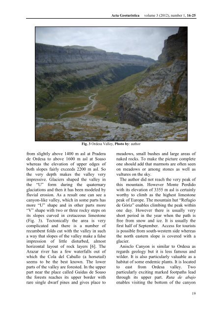
Fig. 3 Ordesa Valley, Photo by: author<br />
from slightly above 1400 m asl at Pradera<br />
de Ordesa to above 1600 m asl at Soaso<br />
whereas the elevation of upper edges of<br />
both slopes fairly exceeds 2200 m asl. So<br />
the very depth makes the valley very<br />
impressive. Glaciers shaped the valley in<br />
the “U” form during the quaternary<br />
glaciations <strong>and</strong> then it has been modeled by<br />
fluvial erosion. As a result one can see a<br />
canyon-like valley, which in some parts has<br />
more “U” shape <strong>and</strong> in other parts more<br />
“V” shape with two or three rocky steps on<br />
its slopes curved in cretaceous limestone<br />
(Fig. 3). Tectonically the area is very<br />
complicated <strong>and</strong> there is a number of<br />
recumbent folds cut with the valley in such<br />
a way that slopes of the valley make a false<br />
impression of little disturbed, almost<br />
horizontal layout of rock layers [6]. The<br />
Arazar river has a few waterfalls out of<br />
which the Cola del Caballo (a horsetail)<br />
seems to be the best known. The lower<br />
parts of the valley are forested. In the upper<br />
part near the place called Guidas de Soaso<br />
the forests reaches its upper border with<br />
rare single dwarf pines <strong>and</strong> gives place to<br />
meadows, small bushes <strong>and</strong> large areas of<br />
naked rocks. To make the picture complete<br />
one should add that marmots are often seen<br />
on meadows or among stones as well as<br />
vultures on the sky.<br />
The author did not reach the very peak of<br />
this mountain. However Monte Perdido<br />
with its elevation of 3355 m asl is certainly<br />
worthy to climb as the highest limestone<br />
peak of Europe. The mountain hut “Refugio<br />
de Gόriz” enables climbing the peak within<br />
one day. However there is usually very<br />
short period in the year when the path is<br />
free from snow <strong>and</strong> ice. It is usually the<br />
first half of September. Access for tourists<br />
is possible from south-western side whereas<br />
the north eastern slope is covered with a<br />
glacier.<br />
Anisclo Canyon is similar to Ordesa as<br />
regards geology but it is less famous <strong>and</strong><br />
wilder. It is also particularly valuable as a<br />
habitat of some endemic plants. It is located<br />
to east from Ordesa valley. Two<br />
particularly exciting marked footpaths lead<br />
through its upper part. Ruta de abajo<br />
enables visiting the bottom of the canyon<br />
19