Interweaving Geological and Cultural Heritages ... - Acta Geoturistica
Interweaving Geological and Cultural Heritages ... - Acta Geoturistica
Interweaving Geological and Cultural Heritages ... - Acta Geoturistica

Create successful ePaper yourself
Turn your PDF publications into a flip-book with our unique Google optimized e-Paper software.
<strong>Acta</strong> <strong>Geoturistica</strong> volume 3 (2012), number 1, 16-25<br />
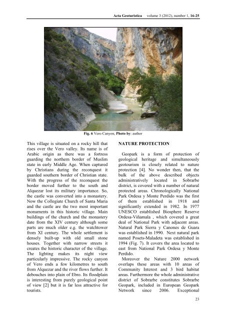
Fig. 6 Vero Canyon, Photo by: author<br />
This village is situated on a rocky hill that<br />
rises over the Vero valley. Its name is of<br />
Arabic origin as there was a fortress<br />
guarding the northern border of Muslim<br />
state in early Middle Age. When captured<br />
by Christians during the reconquest it<br />
guarded southern border of Christian state.<br />
With the progress of the reconquest the<br />
border moved further to the south <strong>and</strong><br />
Alquezar lost its military importance. So,<br />
the castle was converted into a monastery.<br />
Now the Collegiate Church of Santa Maria<br />
<strong>and</strong> the castle are the two most important<br />
monuments in this historic village. Main<br />
buildings of the church <strong>and</strong> the monastery<br />
date from the XIV century although some<br />
parts are much older e.g. the watchtower<br />
from XI century. The whole settlement is<br />
densely built-up with old small stone<br />
houses. Together with narrow streets it<br />
creates the historic character of the village.<br />
The lighting makes its night view<br />
particularly impressive. The rocky canyon<br />
of Vero ends a few kilometres to south<br />
from Alquezar <strong>and</strong> the river flows further. It<br />
debouches into plain of Ebro. Its floodplain<br />
is interesting from purely geological point<br />
of view [2] but it is far less attractive for<br />
tourists.<br />
NATURE PROTECTION<br />
Geopark is a form of protection of<br />
geological heritage <strong>and</strong> simultaneously<br />
geotourism is closely related to nature<br />
protection [4]. No wonder then, that the<br />
bulk of the above described objects<br />
administratively located in Sobrarbe<br />
district, is covered with a number of natural<br />
protected areas. Chronologically National<br />
Park Ordesa y Monte Perdido was the first<br />
of them established in 1918 <strong>and</strong><br />
significantly extended in 1982. In 1977<br />
UNESCO established Biosphere Reserve<br />
Ordesa-Viñamala , which covered a great<br />
deal of National Park with adjacent areas.<br />
Natural Park Sierra y Canones de Guara<br />
was established in 1990. Next natural park<br />
named Posets-Maladeta was established in<br />
1994 (Fig. 7). It covers the area located to<br />
east from National Park Ordesa y Monte<br />
Perdido.<br />
Moreover the Nature 2000 network<br />
overlaps these areas with 10 areas of<br />
Community Interest <strong>and</strong> 3 bird habitat<br />
areas. Furthermore the whole administrative<br />
district of Sobrarbe constitutes Sobrarbe<br />
Geopark, included in European Geopark<br />
Network since 2006. Exceptional<br />
23