Proposed Amendment of the Kiltimagh Local Area Plan 2010-2016
Proposed Amendment of the Kiltimagh Local Area Plan 2010-2016
Proposed Amendment of the Kiltimagh Local Area Plan 2010-2016

You also want an ePaper? Increase the reach of your titles
YUMPU automatically turns print PDFs into web optimized ePapers that Google loves.
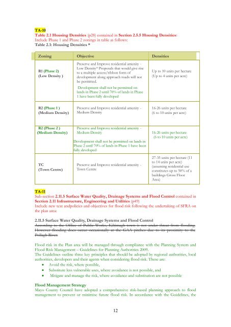
TA-10<br />
Table 2.1 Housing Densities (p28) contained in Section 2.5.5 Housing Densities:<br />
Include Phase 1 and Phase 2 zonings in table as follows:<br />
Table 2.1: Housing Densities *<br />
Zoning Objective Densities<br />
R1 (Phase 2)<br />
(Low Density )<br />
Preserve and Improve residential amenity -<br />
Low Density* Proposals that would give rise<br />
to a multiple access/ribbon form <strong>of</strong><br />
development along approach roads will not<br />
be permitted.<br />
Development shall not be permitted on<br />
lands in Phase 2 until 70% <strong>of</strong> lands in Phase<br />
1 have been fully developed<br />
Up to 10 units per hectare<br />
(Up to 4 units per acre)<br />
R2 (Phase 1 )<br />
(Medium Density)<br />
Preserve and Improve residential amenity -<br />
Medium Density<br />
16-26 units per hectare<br />
(6 to 10 units per acre)<br />
R2 (Phase 2 )<br />
(Medium Density)<br />
TC<br />
(Town Centre)<br />
Preserve and Improve residential amenity -<br />
Medium Density<br />
Development shall not be permitted on lands in<br />
Phase 2 until 70% <strong>of</strong> lands in Phase 1 have been<br />
fully developed<br />
Preserve and Improve residential amenity -<br />
Town Centre<br />
16-26 units per hectare<br />
(6 to 10 units per acre)<br />
27-35 units per hectare (11<br />
to 14 units per acre)<br />
(assuming residential use<br />
constitutes up to 50% <strong>of</strong> a<br />
buildings Gross Floor<br />
<strong>Area</strong>)<br />
TA-11<br />
Sub-section 2.11.5 Surface Water Quality, Drainage Systems and Flood Control contained in<br />
Section 2.11 Infrastructure, Engineering and Utilities (p49)<br />
Include new text andpolicies and objectives for flood risk following <strong>the</strong> undertaking <strong>of</strong> SFRA on<br />
<strong>the</strong> plan area:<br />
2.11.5 Surface Water Quality, Drainage Systems and Flood Control<br />
According to <strong>the</strong> Office <strong>of</strong> Public Works, <strong>Kiltimagh</strong> town is not under threat from flooding.<br />
However flooding does occur occasionally at <strong>the</strong> GAA pitches due to its proximity to <strong>the</strong><br />
Pollagh River.<br />
Flood risk in <strong>the</strong> <strong>Plan</strong> area will be managed through compliance with <strong>the</strong> <strong>Plan</strong>ning System and<br />
Flood Risk Management – Guidelines for <strong>Plan</strong>ning Authorities 2009.<br />
The Guidelines outline three key principles that should be adopted by regional authorities, local<br />
authorities, developers and <strong>the</strong>ir agents when considering flood risk. These are:<br />
• Avoid <strong>the</strong> risk, where possible,<br />
• Substitute less vulnerable uses, where avoidance is not possible, and<br />
• Mitigate and manage <strong>the</strong> risk, where avoidance and substitution are not possible<br />
Flood Management Strategy<br />
Mayo County Council have adopted a comprehensive risk-based planning approach to flood<br />
management to prevent or minimise future flood risk. In accordance with <strong>the</strong> Guidelines, <strong>the</strong><br />
12