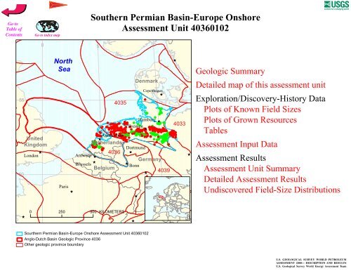
Southern Permian Basin-Europe Onshore Assessment Unit 40360102
Southern Permian Basin-Europe Onshore Assessment Unit 40360102
Southern Permian Basin-Europe Onshore Assessment Unit 40360102

You also want an ePaper? Increase the reach of your titles
YUMPU automatically turns print PDFs into web optimized ePapers that Google loves.
<strong>Southern</strong> <strong>Permian</strong> <strong>Basin</strong>-<strong>Europe</strong> <strong>Onshore</strong><br />
<strong>Assessment</strong> <strong>Unit</strong> <strong>40360102</strong><br />
0<br />
5<br />
10<br />
North<br />
Sea<br />
ÊÚ<br />
55<br />
4035<br />
Denmark<br />
Copenhagen<br />
ÊÚ<br />
#<br />
50<br />
<strong>Unit</strong>ed<br />
Kingdom<br />
ÊÚ<br />
London<br />
Antwerp<br />
Brussels<br />
## ## # # #<br />
#<br />
Hamburg<br />
# # ÊÚ<br />
## #<br />
# # ### #<br />
# #<br />
#<br />
##<br />
# ## # #<br />
##<br />
#### Bremen<br />
# # ## #<br />
## ##<br />
ÊÚ<br />
##<br />
##<br />
#<br />
## ### ##<br />
# #<br />
# ## ## #<br />
## ## # # # # # #<br />
# #<br />
##<br />
###<br />
# Amsterdam<br />
#<br />
#<br />
# ##<br />
# ## ##<br />
#<br />
#<br />
ÊÚ<br />
## #<br />
##<br />
# # # #<br />
#<br />
Netherlands<br />
## #<br />
#<br />
# # #<br />
## ###<br />
### Dortmund<br />
#<br />
4036 ÊÚ<br />
ÊÚ<br />
Germany<br />
ÊÚ<br />
ÊÚ<br />
Belgium<br />
Bonn<br />
ÊÚ<br />
4039<br />
4033<br />
ÊÚ<br />
Paris<br />
ÊÚ<br />
ÊÚ<br />
ÊÚ<br />
ÊÚ<br />
0 250 500 KILOMETERS<br />
ÊÚ<br />
ÊÚ<br />
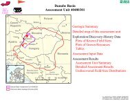
Sourthern <strong>Permian</strong> <strong>Basin</strong>-<strong>Europe</strong> <strong>Onshore</strong> <strong>Assessment</strong> <strong>Unit</strong> <strong>40360102</strong><br />
Anglo-Dutch <strong>Basin</strong> Geologic Province 4036<br />
Other geologic province boundary
USGS PROVINCE: Anglo-Dutch <strong>Basin</strong> (4036)<br />
GEOLOGIST: D.L. Gautier<br />
TOTAL PETROLEUM SYSTEM: Carboniferous-Rotliegend (403601)<br />
ASSESSMENT UNIT: <strong>Southern</strong> <strong>Permian</strong> <strong>Basin</strong>-<strong>Europe</strong> <strong>Onshore</strong> (<strong>40360102</strong>)<br />
DESCRIPTION: The total petroleum system and corresponding assessment unit coincide with the<br />
extent of thermally mature Westphalian (coal measure) source rocks and related gas and liquid<br />
accumulations in the onshore area adjacent to the southern North Sea on the <strong>Europe</strong>an continent, mainly<br />
in the Netherlands and Germany.<br />
SOURCE ROCKS: Coals and carbonaceous shales, mainly of Westphalian and Stephanian (Upper<br />
Carboniferous) age, were deposited in the foreland north of the Variscan orogenic belt. The organic<br />
matter in the coal measures consists mainly of Type III terrigenous kerogen, although Type II kerogen is<br />
also present. The coals and carbonaceous shales constitute two distinct source rock components, with<br />
the coals containing approximately 60 percent TOC and Type III kerogen, whereas the carbonaceous<br />
shale have approximately 1 percent TOC and mixed Type II and Type III kerogen.<br />
MATURATION: Source rocks became mature for oil and other liquids as early as Triassic time in<br />
some areas and for natural gas by early Jurassic time. Principal gas generation occurred in late Jurassic<br />
and Late Cretaceous time. In some areas gas generation has probably continued to the present.<br />
MIGRATION: Initial gas migration probably accompanied earliest generation, and has continued to<br />
the present. Migration pathways are mainly along porous and permeable sandstones, as well as<br />
fractures in fine-grained sedimentary rocks.<br />
RESERVOIR ROCKS: Best reservoir rocks are in the Rotliegend, particularly in eolian sandstone<br />
facies of several types. The entire Rotliegend contains reservoir intervals, but eolian dunes generally<br />
provide the highest quality reservoirs. Other Rotliegend reservoir facies include sheet flood and fluvial<br />
sandstones and relatively coarse grained fluvial channel deposits. Reservoir quality in the Rotliegend is<br />
strongly influenced by both depositional facies and by diagenetic processes, particularly precipitation of<br />
authigenic illite. In addition to the Rotliegendes, reservoir quality rocks are included in the<br />
Carboniferous fluvial channels, and in the Zechstein and Lower Cretaceous intervals.<br />
TRAPS AND SEALS: Excellent regional seals are provided by evaporite and carbonate rocks of the<br />
Zechstein. Local lithologic variations provide stratigraphically heterogeneous distributions of gas<br />
accumulations.<br />
REFERENCES:<br />
Ziegler, Karen, Turner, Peter, and Daines, Stephen R., eds., 1997, Petroleum geology of the<br />
<strong>Southern</strong> North Sea–Future Potential: London, Geological Society, Special Publication 123,<br />
209 p.<br />
Page 1
Abbotts, I.L., 1991, <strong>Unit</strong>ed Kingdom Oil and Gas Fields 25 Years Commemorative Volume:<br />
London, The Geological Society, Memoir 14, p. 385-523.<br />
Stauble, A.J. and Milius, G., 1970, Geology of Groningen Gas Field, Netherlands, in Michel T.<br />
Halbouty, ed., Geology of giant petroleum fields: Tulsa, American Association of Petroleum<br />
Geologists, p. 359-369.<br />
Glennie, K.W., and Provan, D.M.J., 1990, in J. Brooks, ed., Classic Petroleum Provinces: Geological<br />
Society of London Special Publication 50, p. 399-416.<br />
Page 2
4 6 8 10 12<br />
Denmark<br />
Odense Denmark<br />
North Sea<br />
4035<br />
Denmark<br />
54<br />
<strong>40360102</strong><br />
Bremen<br />
Hamburg<br />
4033<br />
4036<br />
Amsterdam<br />
52<br />
The Hague<br />
Rotterdam<br />
Netherlands<br />
4038<br />
Antwerpen<br />
Gent<br />
Bruxelles<br />
4037<br />
100 KILOMETERS<br />
Belgium<br />
4036<br />
Duisburg<br />
Dortmund<br />
Essen<br />
Koln<br />
Liege<br />
Bonn<br />
Germany<br />
4046<br />
4036<br />
<strong>Southern</strong> <strong>Permian</strong> <strong>Basin</strong>-<strong>Europe</strong> <strong>Onshore</strong><br />
<strong>Assessment</strong> <strong>Unit</strong> - <strong>40360102</strong><br />
EXPLANATION<br />
Hydrography<br />
Shoreline<br />
Geologic province code and boundary<br />
Country boundary<br />
Gas field centerpoint<br />
Oil field centerpoint<br />
Projection: Robinson. Central meridian: 0<br />
<strong>40360102</strong><br />
<strong>Assessment</strong> unit<br />
code and boundary
SEVENTH APPROXIMATION<br />
NEW MILLENNIUM WORLD PETROLEUM ASSESSMENT<br />
DATA FORM FOR CONVENTIONAL ASSESSMENT UNITS<br />
Date:………………………….. 6/26/98<br />
<strong>Assessment</strong> Geologist:…….. D.L. Gautier<br />
Region:……………………….. <strong>Europe</strong> Number: 4<br />
Province:……………………… Anglo-Dutch <strong>Basin</strong> Number: 4036<br />
Priority or Boutique.………… Priority<br />
Total Petroleum System:…… Carboniferous-Rotliegend Number: 403601<br />
<strong>Assessment</strong> <strong>Unit</strong>:…………… <strong>Southern</strong> <strong>Permian</strong> <strong>Basin</strong>-<strong>Europe</strong> <strong>Onshore</strong> Number: <strong>40360102</strong><br />
* Notes from Assessor<br />
CHARACTERISTICS OF ASSESSMENT UNIT<br />
Oil (20,000 cfg/bo overall):…<br />
Gas<br />
What is the minimum field size?………. 1 mmboe grown (>1mmboe)<br />
(the smallest field that has potential to be added to reserves in the next 30 years)<br />
Number of discovered fields exceeding minimum size:………… Oil: 100 Gas: 230<br />
Established (>13 fields) X Frontier (1-13 fields) Hypothetical (no fields)<br />
Median size (grown) of discovered oil fields (mmboe):<br />
1st 3rd 15.5 2nd 3rd 6.25 3rd 3rd 11<br />
Median size (grown) of discovered gas fields (bcfg):<br />
1st 3rd 130 2nd 3rd 85 3rd 3rd 55<br />
<strong>Assessment</strong>-<strong>Unit</strong> Probabilities:<br />
Attribute Probability of occurrence (0-1.0)<br />
1. CHARGE: Adequate petroleum charge for an undiscovered field > minimum size……………… 1.0<br />
2. ROCKS: Adequate reservoirs, traps, and seals for an undiscovered field > minimum size…… 1.0<br />
3. TIMING OF GEOLOGIC EVENTS: Favorable timing for an undiscovered field > minimum size 1.0<br />
<strong>Assessment</strong>-<strong>Unit</strong> GEOLOGIC Probability (Product of 1, 2, and 3):……...…….....…. 1.0<br />
4. ACCESSIBILITY: Adequate location to allow exploration for an undiscovered field<br />
> minimum size……………………………………………………..………………..……..………… 1.0<br />
UNDISCOVERED FIELDS<br />
Number of Undiscovered Fields: How many undiscovered fields exist that are > minimum size?:<br />
(uncertainty of fixed but unknown values)<br />
Oil fields:…………………………………min. no. (>0) 3 median no. 10 max no. 25<br />
Gas fields:……………………………….min. no. (>0) 30 median no. 150 max no. 300<br />
Size of Undiscovered Fields: What are the anticipated sizes (grown) of the above fields?:<br />
(variations in the sizes of undiscovered fields)<br />
Oil in oil fields (mmbo)………………..…… min. size 1 median size 5 max. size 60<br />
Gas in gas fields (bcfg):…………………... min. size 6 median size 30 max. size 3000<br />
Page 1
<strong>Assessment</strong> <strong>Unit</strong> (name, no.)<br />
<strong>Southern</strong> <strong>Permian</strong> <strong>Basin</strong>-<strong>Europe</strong> Offshore, <strong>40360102</strong><br />
AVERAGE RATIOS FOR UNDISCOVERED FIELDS, TO ASSESS COPRODUCTS<br />
(uncertainty of fixed but unknown values)<br />
Oil Fields: minimum median maximum<br />
Gas/oil ratio (cfg/bo)………………………...……… 450 900 1350<br />
NGL/gas ratio (bngl/mmcfg)…………………....…. 1 2 4<br />
Gas fields: minimum median maximum<br />
Liquids/gas ratio (bngl/mmcfg)….…………..…….. 1 2 4<br />
Oil/gas ratio (bo/mmcfg)………………………….…<br />
SELECTED ANCILLARY DATA FOR UNDISCOVERED FIELDS<br />
(variations in the properties of undiscovered fields)<br />
Oil Fields: minimum median maximum<br />
API gravity (degrees)…………………….…………. 10 35 50<br />
Sulfur content of oil (%)………………………...…..<br />
Drilling Depth (m) ……………...…………….…….. 500 1500 4000<br />
Depth (m) of water (if applicable)……………...…..<br />
Gas Fields: minimum median maximum<br />
Inert gas content (%)……………………….....…… 10 40 80<br />
CO 2 content (%)……………………………….....… 0.5 3 10<br />
Hydrogen-sulfide content (%)………………...…….<br />
Drilling Depth (m)…………………………………… 100 3500 6000<br />
Depth (m) of water (if applicable)………………….<br />
Page 2
<strong>Assessment</strong> <strong>Unit</strong> (name, no.)<br />
<strong>Southern</strong> <strong>Permian</strong> <strong>Basin</strong>-<strong>Europe</strong> Offshore, <strong>40360102</strong><br />
ALLOCATION OF UNDISCOVERED RESOURCES IN THE ASSESSMENT UNIT<br />
TO COUNTRIES OR OTHER LAND PARCELS (uncertainty of fixed but unknown values)<br />
1. Germany represents 66 areal % of the total assessment unit<br />
Oil in Oil Fields: minimum median maximum<br />
Richness factor (unitless multiplier):……….…..…<br />
Volume % in parcel (areal % x richness factor):… 75<br />
Portion of volume % that is offshore (0-100%)…… 0<br />
Gas in Gas Fields: minimum median maximum<br />
Richness factor (unitless multiplier):…………..….<br />
Volume % in parcel (areal % x richness factor):… 85<br />
Portion of volume % that is offshore (0-100%)…… 0<br />
2. Netherlands represents 34 areal % of the total assessment unit<br />
Oil in Oil Fields: minimum median maximum<br />
Richness factor (unitless multiplier):……….…..…<br />
Volume % in parcel (areal % x richness factor):… 25<br />
Portion of volume % that is offshore (0-100%)…… 0<br />
Gas in Gas Fields: minimum median maximum<br />
Richness factor (unitless multiplier):…………..….<br />
Volume % in parcel (areal % x richness factor):… 15<br />
Portion of volume % that is offshore (0-100%)…… 0<br />
3. Province 4035 represents 70 areal % of the total assessment unit<br />
Oil in Oil Fields: minimum median maximum<br />
Richness factor (unitless multiplier):……….…..…<br />
Volume % in parcel (areal % x richness factor):… 75<br />
Portion of volume % that is offshore (0-100%)…… 0<br />
Gas in Gas Fields: minimum median maximum<br />
Richness factor (unitless multiplier):…………..….<br />
Volume % in parcel (areal % x richness factor):… 85<br />
Portion of volume % that is offshore (0-100%)…… 0<br />
4. Province 4036 represents 30 areal % of the total assessment unit<br />
Oil in Oil Fields: minimum median maximum<br />
Richness factor (unitless multiplier):……….…..…<br />
Volume % in parcel (areal % x richness factor):… 25<br />
Portion of volume % that is offshore (0-100%)…… 0<br />
Gas in Gas Fields: minimum median maximum<br />
Richness factor (unitless multiplier):…………..….<br />
Volume % in parcel (areal % x richness factor):… 15<br />
Portion of volume % that is offshore (0-100%)…… 0<br />
Page 3
UNDISCOVERED OIL FIELDS (No.)<br />
4.5<br />
4<br />
3.5<br />
3<br />
2.5<br />
2<br />
1.5<br />
1<br />
0.5<br />
<strong>Southern</strong> <strong>Permian</strong> <strong>Basin</strong>-<strong>Europe</strong> <strong>Onshore</strong>, AU <strong>40360102</strong><br />
Undiscovered Field-Size Distribution<br />
Minimum field size: 1 MMBO<br />
Mean number of<br />
undiscovered fields: 10.8<br />
0<br />
1-
UNDISCOVERED GAS FIELDS (No.)<br />
40<br />
35<br />
30<br />
25<br />
20<br />
15<br />
10<br />
5<br />
<strong>Southern</strong> <strong>Permian</strong> <strong>Basin</strong>-<strong>Europe</strong> <strong>Onshore</strong>, AU <strong>40360102</strong><br />
Undiscovered Field-Size Distribution<br />
Minimum field size: 6 BCFG<br />
Mean number of<br />
undiscovered fields: 154.4<br />
0<br />
6-