Tanezzuft-Ghadames - USGS Energy Resources Program
Tanezzuft-Ghadames - USGS Energy Resources Program
Tanezzuft-Ghadames - USGS Energy Resources Program

Create successful ePaper yourself
Turn your PDF publications into a flip-book with our unique Google optimized e-Paper software.
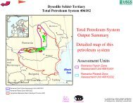
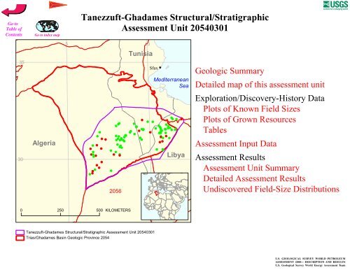
<strong>Tanezzuft</strong>-<strong>Ghadames</strong> Structural/StratigraphicAssessment Unit 20540301355 10TunisiaSfax ÊÚMediterraneanSea30Algeria# # # ## ## ## ## ## # ### # # ## # ## #### # ## ## # # ### ## # ## ### ## # # # ## # ## ### ## #### ## ## #Libya20560 250 500 KILOMETERS<strong>Tanezzuft</strong>-<strong>Ghadames</strong> Structural/Stratigraphic Assessment Unit 20540301Trias/<strong>Ghadames</strong> Basin Geologic Province 2054
<strong>USGS</strong> PROVINCE: Trias/<strong>Ghadames</strong> Basin (2054)GEOLOGIST: T.R. KlettTOTAL PETROLEUM SYSTEM: <strong>Tanezzuft</strong>-<strong>Ghadames</strong> (205403)ASSESSMENT UNIT: <strong>Tanezzuft</strong>-<strong>Ghadames</strong> Structural/Stratigraphic (20540301)DESCRIPTION: This total petroleum system and corresponding assessment unit coincide with the<strong>Ghadames</strong> (Berkine) Basin, bounded on the north by the Talemzane-Gefara Arch, on the east by theHamra Basin, on the south by the Illizi Basin, and on the west by the Amguid-Hassi Touareg structuralaxis.SOURCE ROCKS: The major source rocks are the Silurian <strong>Tanezzuft</strong> Formation and Middle toUpper Devonian mudstone. Frasnian-aged mudstone is the richest among Devonian source rocks.MATURATION: Petroleum generation from Silurian source rocks started as early as theCarboniferous, was interrupted by the Hercynian event, and then peaked from the Late Jurassic to themiddle Cretaceous. Generation from Middle to Upper Devonian source rocks started as early as theLate Triassic and peaked from the Early Cretaceous to the early Tertiary.MIGRATION: Petroleum migrated laterally into adjacent or juxtaposed reservoirs and verticallyalong faults or fractures.RESERVOIR ROCKS: Known reservoir rocks include Cambrian-Ordovician fluvial to marinesandstone, Ordovician to Silurian paralic and marine sandstone, Upper Silurian nearshore to marinesandstone, Devonian and Carboniferous deltaic to marine sandstone, and Triassic fluvial sandstone.TRAPS AND SEALS: Most of the known accumulations are within anticlines, faulted anticlines, orfault blocks. Some combination traps are present. Triassic to Jurassic evaporites, mudstone, andcarbonate rocks provide a regional top seal. Intraformational Paleozoic marine mudstone provides theprimary seal for some reservoirs.REFERENCES:Boote, D.R.D., Clark-Lowes, D.D., and Traut, M.W., 1998, Palaeozoic petroleum systems ofNorth Africa, in Macgregor, D. S., Moody, R.T.J., and Clark-Lowes, D.D., eds.,Petroleum geology of North Africa: London, Geological Society, Special Publication No. 132,p. 7-68.Boudjema, A., 1987, Evolution structurale du bassin petrolier «Triasique» du Sahara Nord Oriental(Algerie): Thèse a l'Universite de Paris-Sud, Centre d'Orsay, 290 p.Daniels, R. P., and Emme, J. J., 1995, Petroleum system model, easteren Algeria, from source rock toaccumulation: when, where, and how? Proceedings of the Seminar on Source Rocks andHydrocarbon Habitat in Tunisia: Entreprise Tunisienne d'Activites Petrolieres Memoir 9, p.101-124.
6 8 10 1232Algeria2054Tunisia30205403012047100 KILOMETERSLibya2054<strong>Tanezzuft</strong>-<strong>Ghadames</strong> Structural/StratigraphicAssessment Unit - 20540301EXPLANATIONHydrographyShorelineGeologic province code and boundaryCountry boundaryGas field centerpointOil field centerpointProjection: Robinson. Central meridian: 020540301Assessment unitcode and boundary
SEVENTH APPROXIMATIONNEW MILLENNIUM WORLD PETROLEUM ASSESSMENTDATA FORM FOR CONVENTIONAL ASSESSMENT UNITSDate:………………………….. 6/16/98Assessment Geologist:…….. T.R. KlettRegion:……………………….. Middle East and North Africa Number: 2Province:……………………… Trias/<strong>Ghadames</strong> Basin Number: 2054Priority or Boutique.………… PriorityTotal Petroleum System:…… <strong>Tanezzuft</strong>-<strong>Ghadames</strong> Number: 205403Assessment Unit:…………… <strong>Tanezzuft</strong>-<strong>Ghadames</strong> Structural/Stratigraphic Number: 20540301* Notes from AssessorCHARACTERISTICS OF ASSESSMENT UNITOil (20,000 cfg/bo overall):…OilWhat is the minimum field size?………. 1 mmboe grown (>1mmboe)(the smallest field that has potential to be added to reserves in the next 30 years)Number of discovered fields exceeding minimum size:………… Oil: 66 Gas: 21Established (>13 fields) X Frontier (1-13 fields) Hypothetical (no fields)Median size (grown) of discovered oil fields (mmboe):1st 3rd 15.7 2nd 3rd 14.4 3rd 3rd 26.9Median size (grown) of discovered gas fields (bcfg):1st 3rd 701.7 2nd 3rd 287.4 3rd 3rd 143.7Assessment-Unit Probabilities:Attribute Probability of occurrence (0-1.0)1. CHARGE: Adequate petroleum charge for an undiscovered field > minimum size……………… 1.02. ROCKS: Adequate reservoirs, traps, and seals for an undiscovered field > minimum size…… 1.03. TIMING OF GEOLOGIC EVENTS: Favorable timing for an undiscovered field > minimum size 1.0Assessment-Unit GEOLOGIC Probability (Product of 1, 2, and 3):……...…….....…. 1.04. ACCESSIBILITY: Adequate location to allow exploration for an undiscovered field> minimum size……………………………………………………..………………..……..………… 1.0UNDISCOVERED FIELDSNumber of Undiscovered Fields: How many undiscovered fields exist that are > minimum size?:(uncertainty of fixed but unknown values)Oil fields:…………………………………min. no. (>0) 14 median no. 73 max no. 202Gas fields:……………………………….min. no. (>0) 6 median no. 38 max no. 105Size of Undiscovered Fields: What are the anticipated sizes (grown) of the above fields?:(variations in the sizes of undiscovered fields)Oil in oil fields (mmbo)………………..…… min. size 1 median size 16 max. size 2488Gas in gas fields (bcfg):…………………... min. size 6 median size 70 max. size 3110Page 1
Assessment Unit (name, no.)<strong>Tanezzuft</strong>-<strong>Ghadames</strong> Structural/Stratigraphic, 20540301AVERAGE RATIOS FOR UNDISCOVERED FIELDS, TO ASSESS COPRODUCTS(uncertainty of fixed but unknown values)Oil Fields: minimum median maximumGas/oil ratio (cfg/bo)………………………...……… 686 1372 2058NGL/gas ratio (bngl/mmcfg)…………………....…. 20 40 60Gas fields: minimum median maximumLiquids/gas ratio (bngl/mmcfg)….…………..…….. 56 112 168Oil/gas ratio (bo/mmcfg)………………………….…SELECTED ANCILLARY DATA FOR UNDISCOVERED FIELDS(variations in the properties of undiscovered fields)Oil Fields: minimum median maximumAPI gravity (degrees)…………………….…………. 30 42 52Sulfur content of oil (%)………………………...…..Drilling Depth (m) ……………...…………….…….. 1200 2800 4500Depth (m) of water (if applicable)……………...…..Gas Fields: minimum median maximumInert gas content (%)……………………….....……CO 2 content (%)……………………………….....…Hydrogen-sulfide content (%)………………...…….Drilling Depth (m)…………………………………… 1000 3050 7000Depth (m) of water (if applicable)………………….Page 2
Assessment Unit (name, no.)<strong>Tanezzuft</strong>-<strong>Ghadames</strong> Structural/Stratigraphic, 20540301ALLOCATION OF UNDISCOVERED RESOURCES IN THE ASSESSMENT UNITTO COUNTRIES OR OTHER LAND PARCELS (uncertainty of fixed but unknown values)1. Algeria represents 62.5 areal % of the total assessment unitOil in Oil Fields: median maximumRichness factor (unitless multiplier):……….…..…Volume % in parcel (areal % x richness factor):… 62.5Portion of volume % that is offshore (0-100%)…… 0Gas in Gas Fields: minimum median maximumRichness factor (unitless multiplier):…………..….Volume % in parcel (areal % x richness factor):… 62.5Portion of volume % that is offshore (0-100%)…… 02. Tunisia represents 18.75 areal % of the total assessment unitOil in Oil Fields: minimum median maximumRichness factor (unitless multiplier):……….…..…Volume % in parcel (areal % x richness factor):… 18.75Portion of volume % that is offshore (0-100%)…… 0Gas in Gas Fields: minimum median maximumRichness factor (unitless multiplier):…………..….Volume % in parcel (areal % x richness factor):… 18.75Portion of volume % that is offshore (0-100%)…… 03. Libya represents 18.75 areal % of the total assessment unitOil in Oil Fields: minimum median maximumRichness factor (unitless multiplier):……….…..…Volume % in parcel (areal % x richness factor):… 18.75Portion of volume % that is offshore (0-100%)…… 0Gas in Gas Fields: minimum median maximumRichness factor (unitless multiplier):…………..….Volume % in parcel (areal % x richness factor):… 18.75Portion of volume % that is offshore (0-100%)…… 04. Province 2054 represents 91 areal % of the total assessment unitOil in Oil Fields: minimum median maximumRichness factor (unitless multiplier):……….…..…Volume % in parcel (areal % x richness factor):… 91Portion of volume % that is offshore (0-100%)…… 0Gas in Gas Fields: minimum median maximumRichness factor (unitless multiplier):…………..….Volume % in parcel (areal % x richness factor):… 91Portion of volume % that is offshore (0-100%)…… 0Page 3
UNDISCOVERED OIL FIELDS (No.)161412108642<strong>Tanezzuft</strong>-<strong>Ghadames</strong> Structural/Stratigraphic, AU 20540301Undiscovered Field-Size DistributionMinimum field size: 1 MMBOMean number ofundiscovered fields: 80.301-
UNDISCOVERED GAS FIELDS (No.)12108642<strong>Tanezzuft</strong>-<strong>Ghadames</strong> Structural/ Stratigraphic, AU 20540301Undiscovered Field-Size DistributionMinimum field size: 6 BCFGMean number ofundiscovered fields: 41.806-