Carupano Basin Gas - USGS Energy Resources Program
Carupano Basin Gas - USGS Energy Resources Program
Carupano Basin Gas - USGS Energy Resources Program

Create successful ePaper yourself
Turn your PDF publications into a flip-book with our unique Google optimized e-Paper software.
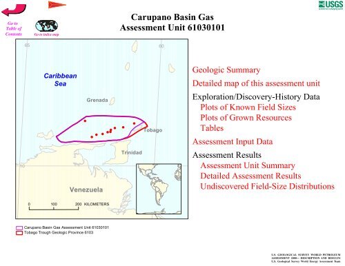
<strong>Carupano</strong> <strong>Basin</strong> <strong>Gas</strong><br />
Assessment Unit 61030101<br />
65 60<br />
Caribbean<br />
Sea<br />
Grenada<br />
#<br />
#<br />
#<br />
#<br />
#<br />
##<br />
#<br />
#<br />
#<br />
Tobago<br />
Trinidad<br />
10<br />
Venezuela<br />
0 100 200 KILOMETERS<br />
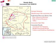
<strong>Carupano</strong> <strong>Basin</strong> <strong>Gas</strong> Assessment Unit 61030101<br />
Tobago Trough Geologic Province 6103
<strong>USGS</strong> PROVINCE: Tobago Trough (6103)<br />
GEOLOGIST: C.J. Schenk<br />
TOTAL PETROLEUM SYSTEM: Lower Cruse (610301)<br />
ASSESSMENT UNIT: <strong>Carupano</strong> <strong>Basin</strong> <strong>Gas</strong> (61030101)<br />
DESCRIPTION: The <strong>Carupano</strong> <strong>Basin</strong> is the southernmost part of the larger Tobago Trough.<br />
The assessment unit is defined by a wide zone of faulting associated with the southern wrench<br />
fault boundary of the Caribbean plate. The northern boundary of the assessment unit is the shelf<br />
slope break. Approximately 25 TCF gas has been discovered in this assessment unit, with<br />
several of the larger structures already tested. The largest field is Patao in Venezuelan waters.<br />
SOURCE ROCKS: Source rocks are postulated to be prodeltaic mudstones coeval with the<br />
Miocene Lower Cruse Formation, similar to the Columbus <strong>Basin</strong> of Trinidad immediately south<br />
of this basin.<br />
MATURATION: Mudstones of the lower Cruse Formation are postulated to have reached<br />
maturity in the Pliocene following deposition of several kilometers of sediment in the Miocene<br />
and lower Pliocene.<br />
MIGRATION: Migration of hydrocarbons from the lower Cruse mudstones was mainly<br />
vertical along faults associated with the wrench fault zone. The timing of faulting was late<br />
Pliocene and Pleistocene.<br />
RESERVOIR ROCKS: Reservoirs are mainly deltaic sandstones of the lower Pliocene, but<br />
deeper turbiditic sandstones sourced by the ancestral Orinoco River may also be present. The<br />
reservoir at Patao is reputed to be in turbidite sandstones.<br />
TRAPS AND SEALS: Trap are mainly structural, with normal fault traps formed by<br />
transtension associated with wrench faulting along the 150 km wide fault zone of the southern<br />
margin of the Caribbean plate. Traps formed in transpressional segments of the fault zone are<br />
also present. Seals are mainly intraformational mudstones of the Pliocene deltaic section.<br />
REFERENCES:<br />
Leonard, R., 1983, Geology and hydrocarbon accumulations, Columbus <strong>Basin</strong>, offshore<br />
Trinidad: American Association of Petroleum Geologists Bulletin, v. 67, p. 1081-1093.<br />
Robertson, P., and Burke, K., 1989, Evolution of southern Caribbean plate boundary, vicinity of<br />
Trinidad and Tobago: American Association of Petroleum Geologists Bulletin, v. 73,<br />
p. 490-509.<br />
Speed, R., Torrini, R., and Smith, P.L., 1989, Tectonic origin of the Tobago Trough forearc<br />
basin: Journal of Geophysical Research, v. 94, no. B3, p. 2913-2936.
62<br />
6107<br />
Atlantic Ocean<br />
11<br />
6108<br />
50 KILOMETERS<br />
61030101<br />
6103<br />
Trinidad<br />
and Tobago<br />
6103<br />
<strong>Carupano</strong> <strong>Basin</strong> <strong>Gas</strong><br />
Assessment Unit - 61030101<br />
EXPLANATION<br />
Hydrography<br />
Shoreline<br />
Geologic province code and boundary<br />
Country boundary<br />
<strong>Gas</strong> field centerpoint<br />
Oil field centerpoint<br />
Projection: Robinson. Central meridian: 0<br />
61030101<br />
Assessment unit<br />
code and boundary
SEVENTH APPROXIMATION<br />
NEW MILLENNIUM WORLD PETROLEUM ASSESSMENT<br />
DATA FORM FOR CONVENTIONAL ASSESSMENT UNITS<br />
Date:………………………….. 5/18/99<br />
Assessment Geologist:…….. C. J. Schenk<br />
Region:……………………….. Central and South America Number: 6<br />
Province:……………………… Tobago Trough Number: 6103<br />
Priority or Boutique.………… Priority<br />
Total Petroleum System:…… Lower Cruse Number: 610301<br />
Assessment Unit:…………… <strong>Carupano</strong> <strong>Basin</strong> <strong>Gas</strong> Number: 61030101<br />
* Notes from Assessor Lower 48 growth factor.<br />
CHARACTERISTICS OF ASSESSMENT UNIT<br />
Oil (20,000 cfg/bo overall):…<br />
<strong>Gas</strong><br />
What is the minimum field size?………. 5 mmboe grown (>1mmboe)<br />
(the smallest field that has potential to be added to reserves in the next 30 years)<br />
Number of discovered fields exceeding minimum size:………… Oil: 0 <strong>Gas</strong>: 10<br />
Established (>13 fields) Frontier (1-13 fields) X Hypothetical (no fields)<br />
Median size (grown) of discovered oil fields (mmboe):<br />
1st 3rd 2nd 3rd 3rd 3rd<br />
Median size (grown) of discovered gas fields (bcfg):<br />
1st 3rd 2764 2nd 3rd 2135 3rd 3rd<br />
Assessment-Unit Probabilities:<br />
Attribute Probability of occurrence (0-1.0)<br />
1. CHARGE: Adequate petroleum charge for an undiscovered field > minimum size……………… 1.0<br />
2. ROCKS: Adequate reservoirs, traps, and seals for an undiscovered field > minimum size…… 1.0<br />
3. TIMING OF GEOLOGIC EVENTS: Favorable timing for an undiscovered field > minimum size 1.0<br />
Assessment-Unit GEOLOGIC Probability (Product of 1, 2, and 3):……...…….....…. 1.0<br />
4. ACCESSIBILITY: Adequate location to allow exploration for an undiscovered field<br />
> minimum size……………………………………………………..………………..……..………… 1.0<br />
UNDISCOVERED FIELDS<br />
Number of Undiscovered Fields: How many undiscovered fields exist that are > minimum size?:<br />
(uncertainty of fixed but unknown values)<br />
Oil fields:…………………………………min. no. (>0) median no. max no.<br />
<strong>Gas</strong> fields:……………………………….min. no. (>0) 10 median no. 70 max no. 200<br />
Size of Undiscovered Fields: What are the anticipated sizes (grown) of the above fields?:<br />
(variations in the sizes of undiscovered fields)<br />
Oil in oil fields (mmbo)………………..……min. size median size max. size<br />
<strong>Gas</strong> in gas fields (bcfg):……………………min. size 30 median size 96 max. size 10000<br />
Page 1
Assessment Unit (name, no.)<br />
<strong>Carupano</strong> <strong>Basin</strong> <strong>Gas</strong>, 61030101<br />
AVERAGE RATIOS FOR UNDISCOVERED FIELDS, TO ASSESS COPRODUCTS<br />
(uncertainty of fixed but unknown values)<br />
Oil Fields: minimum median maximum<br />
<strong>Gas</strong>/oil ratio (cfg/bo)………………………...………<br />
NGL/gas ratio (bngl/mmcfg)…………………....….<br />
<strong>Gas</strong> fields: minimum median maximum<br />
Liquids/gas ratio (bngl/mmcfg)….…………..…….. 5 10 15<br />
Oil/gas ratio (bo/mmcfg)………………………….…<br />
SELECTED ANCILLARY DATA FOR UNDISCOVERED FIELDS<br />
(variations in the properties of undiscovered fields)<br />
Oil Fields: minimum median maximum<br />
API gravity (degrees)…………………….………….<br />
Sulfur content of oil (%)………………………...…..<br />
Drilling Depth (m) ……………...…………….……..<br />
Depth (m) of water (if applicable)……………...…..<br />
<strong>Gas</strong> Fields: minimum median maximum<br />
Inert gas content (%)……………………….....……<br />
CO 2 content (%)……………………………….....…<br />
Hydrogen-sulfide content(%)………………...…….<br />
Drilling Depth (m)…………………………………… 1000 2500 5000<br />
Depth (m) of water (if applicable)…………………. 10 100 200<br />
Page 2
Assessment Unit (name, no.)<br />
<strong>Carupano</strong> <strong>Basin</strong> <strong>Gas</strong>, 61030101<br />
ALLOCATION OF UNDISCOVERED RESOURCES IN THE ASSESSMENT UNIT<br />
TO COUNTRIES OR OTHER LAND PARCELS (uncertainty of fixed but unknown values)<br />
1. Trinidad and Tobago represents 40 areal % of the total assessment unit<br />
Oil in Oil Fields: minimum median maximum<br />
Richness factor (unitless multiplier):……….…..…<br />
Volume % in parcel (areal % x richness factor):…<br />
Portion of volume % that is offshore (0-100%)……<br />
<strong>Gas</strong> in <strong>Gas</strong> Fields: minimum median maximum<br />
Richness factor (unitless multiplier):…………..….<br />
Volume % in parcel (areal % x richness factor):… 36<br />
Portion of volume % that is offshore (0-100%)…… 100<br />
2. Venezuela represents 56 areal % of the total assessment unit<br />
Oil in Oil Fields: minimum median maximum<br />
Richness factor (unitless multiplier):……….…..…<br />
Volume % in parcel (areal % x richness factor):…<br />
Portion of volume % that is offshore (0-100%)……<br />
<strong>Gas</strong> in <strong>Gas</strong> Fields: minimum median maximum<br />
Richness factor (unitless multiplier):…………..….<br />
Volume % in parcel (areal % x richness factor):… 60<br />
Portion of volume % that is offshore (0-100%)…… 100<br />
3. Grenada represents 4 areal % of the total assessment unit<br />
Oil in Oil Fields: minimum median maximum<br />
Richness factor (unitless multiplier):……….…..…<br />
Volume % in parcel (areal % x richness factor):…<br />
Portion of volume % that is offshore (0-100%)……<br />
<strong>Gas</strong> in <strong>Gas</strong> Fields: minimum median maximum<br />
Richness factor (unitless multiplier):…………..….<br />
Volume % in parcel (areal % x richness factor):… 4<br />
Portion of volume % that is offshore (0-100%)…… 100<br />
Page 3
25<br />
<strong>Carupano</strong> <strong>Basin</strong> <strong>Gas</strong>, AU 61030101<br />
Undiscovered Field-Size Distribution<br />
UNDISCOVERED GAS FIELDS (No.)<br />
20<br />
15<br />
10<br />
5<br />
Minimum field size: 30 BCFG<br />
Mean number of<br />
undiscovered fields: 77.4<br />
0<br />
24-