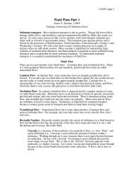
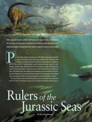
Fence diagrams, page 1 Geology 109L Fence ... - MyGeologyPage
Fence diagrams, page 1 Geology 109L Fence ... - MyGeologyPage
Fence diagrams, page 1 Geology 109L Fence ... - MyGeologyPage

Create successful ePaper yourself
Turn your PDF publications into a flip-book with our unique Google optimized e-Paper software.
Isopach Maps:<br />
A second good visualization tool for three dimensional stratigraphic reconstructions is a<br />
map of the thickness of a unit of interest, i.e. an isopach (same thickness) map. These maps consist<br />
of contours like a topographic map, but they represent the thickness of a unit rather than the<br />
elevation of the surface. Various other maps can be constructed. For example, the depth to a<br />
certain unit can be very useful. Sometimes % clay in a sandstone is useful, etc. They are all<br />
constructed by plotting the desired data on a base map and contouring it to identify systematic<br />
variations. This type of work is extremely common in both hydrology and resource exploration<br />
(gas, oil, metals, etc.), and you will hopefully see why as you work through this lab.<br />
The basic principles of contouring are simple. A contour is a line of constant value. The<br />
spacing of contours on a map reflects the steepness of a gradient or slope. The path of a contour is<br />
the expression of the variations on the surface that the contours represent. A group of equally<br />
spaced contour lines would represent an inclined plane, whereas concentric rings would denote a<br />
domal or basinal feature. There are, as with most techniques, a few rules to remember.<br />
1. A contour never crosses over itself or another contour because a single point can not have two<br />
values.<br />
2. Contours must not touch each other except where the gradient is VERY steep relative to your<br />
contour interval. For example, if you have two data points very close to each other with<br />
radically different values, the lines may touch. On a topographic map, points at the top and<br />
bottom of a cliff can have a very different elevation, but be at essentially the same place on<br />
the map. There are no points like this in this lab. Therefore, your contour lines must not<br />
touch each other.<br />
3. Where a slope or gradient reverses direction, as on a ridge or in a valley, the highest or lowest<br />
contour, respectively, must be repeated in map view; i.e., it forms a u-shape or a loop.<br />
4. Closed contours around small areas represent isolated values which are anomalous to the local<br />
slope or gradient. If the anomaly is lower than the normal gradient, the contour is<br />
characterized by short hachured lines pointing inward.<br />
Your Job:<br />
You have been hired to help a small city evaluate locations to place another water supply<br />
well. The city is built on a sequence of lacustrine and fluvial rocks in an area that was tectonically<br />
active. Due to previous tectonic activity, specifically regional tilting and folding, several<br />
unconformities are locally developed that truncate the potential aquifer. The city has hired you to<br />
map out target areas and depths for drilling. To site a good well, you will need a three dimensional<br />
picture of the subsurface distribution of the aquifer, creatively called Unit 6, as well as a map of its<br />
thickness to estimate potential water volume. In this case, thicker is better. Your job is to construct<br />
a fence diagram showing the distribution of all of the geological units, construct maps showing the<br />
depth to the top of Unit 6 and the thickness of Unit 6, and write a short report recommending<br />
potential drill sites.<br />
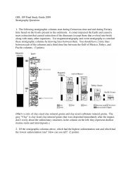
The following table shows 18 well sections, which are your sources of data. The wells that<br />
intersect Unit 6 at depths shallower than 1500 feet are already being used for water sources. You<br />
will need to recommend new locations where less data are available. Each well penetrates several or<br />
all ten units in the sequence of rocks. Luckily, the previous geologist accurately identified all of the<br />
units before being offered a much higher paying job elsewhere because of the skills she learned<br />
citing water wells when she was in your job. Unit 1 is the youngest and Unit 10 is the oldest. Unit<br />
10 consists of metamorphic rather than sedimentary rocks. An "X" in the table represents the<br />
formation in which the well started. Numbers in the columns represent the depths at which the top<br />
of each unit was encountered in feet (most wells in the US are still reported in feet!). Certain units<br />
are absent in some wells. There is no actual faulting in the region so all of the missing units are<br />
truncated against unconformities. Also, the previous geologist demonstrated that all of the units<br />
were initially deposited over the entire area.<br />
<strong>Fence</strong> <strong>diagrams</strong>, <strong>page</strong> 2