Facies Analysis and Correlations - MyGeologyPage
Facies Analysis and Correlations - MyGeologyPage
Facies Analysis and Correlations - MyGeologyPage

You also want an ePaper? Increase the reach of your titles
YUMPU automatically turns print PDFs into web optimized ePapers that Google loves.
Geology 109L<br />
Lab 8: <strong>Facies</strong> <strong>Analysis</strong> <strong>and</strong> <strong>Correlations</strong>:<br />
Sequence Stratigraphy in the Book Cliffs, Utah<br />
Goal: In this lab, you will put together your knowledge of near-shore facies <strong>and</strong> sequence<br />
stratigraphy to correlate sections <strong>and</strong> interpret facies changes in the Cretaceous stratigraphy of the<br />
Book Cliffs.<br />
Introduction<br />
<strong>Facies</strong> analysis is an important part of any stratigraphic study. The basic idea is to<br />
recognize how different depositional environments are expressed by the development of<br />
characteristic structures, lithologies <strong>and</strong> organic components in sedimentary rocks. The usual way<br />
to reconstruct the depositional history of an area is to group strata into facies assemblages; that is,<br />
measuring numerous stratigraphic sections, examining the rocks, <strong>and</strong> assigning those rocks a<br />
depositional environment based on sedimentary structures, paleontological evidence <strong>and</strong> lithology.<br />
When this has been accomplished, the measured sections are correlated using the facies<br />
assemblages <strong>and</strong> sequence stratigraphic concepts, <strong>and</strong> three dimensional models of deposition are<br />
constructed. When doing this, the stratigrapher must not only be familiar with sedimentary rocks<br />
<strong>and</strong> structures, but also bear in mind the regional history of the area.<br />
It is important to consider facies changes when correlating measured sections. A facies<br />
change is the natural gradation from one environment to another. For example, at a certain point of<br />
sea level, the coastal plain of Hot-As-Heck, Texas grades into a tidal flat, which grades along the<br />
shoreline into a beach, both of which grade out to the deeper waters of the Gulf of Mexico. The<br />
sediments in these environments differ, but there are no clean breaks dividing the environments; the<br />
sediments change continuously. Add to this a stream that flows out to the Gulf, <strong>and</strong> you add more<br />
environments. When sea level rises or falls, those environments migrate, producing a vertical<br />
stacking of the sediments deposited in these laterally contiguous environments.<br />
Stratigraphy in the Book Cliffs<br />
During Late Cretaceous time, a time of world-wide high sea level, the stable cratonic area of<br />
North America was inundated by marine waters. The invasive body of water is called the Western<br />
Interior Seaway, or the Great Cretaceous Seaway. It was approximately 4800 km long <strong>and</strong> up to<br />
1600 km wide. At this time, the western side of the seaway was bordered by a forel<strong>and</strong> basin<br />
formed by thrusting of the Columbian-Sevier orogeny (which runs through present day Nevada),<br />
<strong>and</strong> on the east by a stable exposed platform. Several basins formed due to the weight of the thrust<br />
sheets loading the crust <strong>and</strong> causing subsidence. The stratigraphy <strong>and</strong> lithofacies differ in the<br />
different basins, but in all, coal <strong>and</strong> natural gas deposits are an important economic consideration.<br />
(Did you know that the Denver area has abundant petroleum resources? They are from organics<br />
deposited in this environment during Cretaceous time.) Underst<strong>and</strong>ing the depositional<br />
environments <strong>and</strong> stratigraphy in these basins is very important for exploration for these resources.<br />
They also provide information on the timing <strong>and</strong> influences of thrust sheet movement; by dating<br />
sediments in these basins, the timing <strong>and</strong> location of tectonic activity along the western paleomargin<br />
of North America can be accurately constrained.<br />
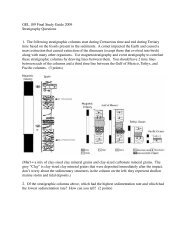
ASSIGNMENT<br />
1) Identify the facies assemblages on the measured sections that will be provided in lab <strong>and</strong> color<br />
the units different colors. Remember to consider Walther’s Law: Neighboring environments<br />
should appear next to each other vertically unless an unconformity is present.<br />
2) Identify <strong>and</strong> correlate the unconformities between sections. Some do not appear in all sections.<br />
Think about why <strong>and</strong> how to deal with the correlations.<br />
Book Cliffs, Page 1
3) Correlate the facies <strong>and</strong> facies changes between sections considering the temporal significance<br />
of the unconformities. Color the areas between sections with the facies you predict.<br />
4) On the far right of the stratigraphic columns, construct an approximate sea level curve for the<br />
area based on the location of unconformities <strong>and</strong> shifts in facies distributions.<br />
5) Answer the questions at the bottom of the stratigraphic columns.<br />
6) Turn in your correlations.<br />
Important Note: The stratigraphic columns are taken from Yoshida (2000), who provided a<br />
correlation similar to the one I am asking you to do. However, Yoshida (2000) also mapped facies<br />
changes <strong>and</strong> unconformities along cliffs between sections. Thus, Yoshida (2000) had much more<br />
information than you do, <strong>and</strong> the correlations in the paper show much more detail. Also, I slightly<br />
changed the facies I am asking you to map out, because it was unclear to me how Yoshida (2000)<br />
identified some of the facies. Why this matters to you: You are welcome to look up Yoshida’s<br />
paper <strong>and</strong> look at the published correlations, but this is neither required nor particularly encouraged<br />
(or discouraged). The paper may or may not help. It contains complex terminology, making it<br />
difficult to read, <strong>and</strong> you should be able to do this lab without that additional information. If you do<br />
choose to look up the paper, you still need to work through your own correlations based on the<br />
information provided in the lab; they should not be the same as the published ones. I did not get the<br />
published correlation when I tried the correlations myself. Please reference it by answering the<br />
questions on the bottom of the strat section page. Please note that if you use the paper <strong>and</strong> do not<br />
reference it, you will be guilty of plagerism, which broadly consists of using other people’s work<br />
without acknowledging them. Your answers to the questions will NOT affect your grade, unless<br />
you use the paper <strong>and</strong> do not say that you did.<br />
<strong>Facies</strong> Assemblages for the Upper Blackhawk Formation <strong>and</strong> Lower Castlegate S<strong>and</strong>stone<br />
The following descriptions of facies are taken from Yoshida (2000). Use these descriptions <strong>and</strong> the<br />
facies tables that follow them to interpret the depositional environments represented in the<br />
stratigraphic columns that you will correlate for this lab.<br />
Yoshida, S. 2000. Sequence <strong>and</strong> facies architecture of the upper Blackhawk Formation <strong>and</strong> the<br />
Lower Castlegate S<strong>and</strong>stone (Upper Cretaceous), Book Cliffs, Utah, USA. Sedimentary Geology,<br />
v. 136, p. 249-276.<br />
4. Lithofacies assemblages<br />
This study divides the strata of the uppermost Blackhawk Formation <strong>and</strong> the Lower Castlegate<br />
S<strong>and</strong>stone between Horse Canyon <strong>and</strong> Coal Canyon into nine lithofacies assemblages (Table 1).<br />
4.1. Assemblage A: braided-fluvial facies<br />
Assemblage A dominates the lower part of the Lower Castlegate S<strong>and</strong>stone, <strong>and</strong> comprises<br />
superimposed s<strong>and</strong>stone sheets bounded by laterally extensive erosional surfaces (Figs. 3 <strong>and</strong> 4A).<br />
On a single outcrop (e.g. hundreds of metres wide), thick s<strong>and</strong>stone sheets (e.g. 10–20 m)<br />
commonly comprise a few, laterally extensive s<strong>and</strong> bodies. Paleocurrents measured from trough<br />
cross-bedding within each sheet s<strong>and</strong>stone are unimodal, oriented to the south-east <strong>and</strong> east. Many<br />
s<strong>and</strong> bodies within each sheet s<strong>and</strong>stone contain large-scale cross-bedding (2– 13 m high), dipping<br />
in a direction parallel, oblique or normal to local flow. Log impressions, wood/ plant fragments, <strong>and</strong><br />
rare dinosaur/reptile bones occur at the base of s<strong>and</strong>stone sheets. S<strong>and</strong>stone beds within the s<strong>and</strong><br />
bodies are thin (,20 cm) to thick (3–4 m), are mostly fine- to medium-grained, <strong>and</strong> typically have a<br />
pale orange to brown colour. Abundant trough cross-stratification <strong>and</strong> convolute bedding with<br />
minor current ripples occur within beds. Minor associated lithofacies include light-grey shale <strong>and</strong><br />
Book Cliffs, Page 2
siltstone beds. Each s<strong>and</strong>stone sheet shows an incomplete fining-upward profile. Assemblage A is<br />
interpreted to be of braided fluvial origin.<br />
4.2. Assemblage B: tidally influenced s<strong>and</strong>y fluvial facies<br />
Assemblage B is characterized by lenticular to tabular s<strong>and</strong> bodies 2–11 m thick, which<br />
commonly contain large-scale cross-bedding (1.5–11 m high) <strong>and</strong> mud drapes. Some of these can<br />
be classified as inclined heterolithic strata (hereafter called IHS; Thomas et al., 1987) (Figs. 3, 5 <strong>and</strong><br />
6), but some lack the diagnostic mud/s<strong>and</strong> couplets. S<strong>and</strong>stones exhibit a white to very light<br />
grey/brown colour. They are mostly very fine- to fine-grained, but medium-grained s<strong>and</strong>stone with<br />
abundant lag deposits (e.g. wood fragments <strong>and</strong> reptile bones) occurs near the erosional base of<br />
some s<strong>and</strong> bodies (Fig. 4B). In many localities these s<strong>and</strong> bodies laterally coalesce to form a sheet<br />
geometry in the lower part of the assemblage (Fig. 4A). Each sheet s<strong>and</strong>stone has an upward-fining<br />
profile (Figs. 3 <strong>and</strong> 5). Trough cross-bedding <strong>and</strong> convolute bedding are the most common<br />
sedimentary structures in this assemblage. Log impressions are common at the base of sheet<br />
s<strong>and</strong>stones. Siltstones typically have a light grey to greenish grey colour. Shales are dark grey <strong>and</strong><br />
carbonaceous, <strong>and</strong> contain abundant vascular plant fragments. In addition to IHS, this assemblage<br />
contains many sedimentary structures indicative of tidal influence (e.g. Shanley et al., 1992), such<br />
as sigmoidal bedding (Fig. 7A), fine organic detritus along the cross-stratification (Fig. 7B),<br />
oscillation/bidirectional ripples (Fig. 7C), flaser/wavy/lenticular bedding <strong>and</strong> multiple reactivation<br />
surfaces. Trace fossils including Teredolites <strong>and</strong> various crawling/resting traces occur in the<br />
s<strong>and</strong>stones, which also contain rare dinosaur footprints (Fig. 5). Paleocurrents measured from the<br />
trough cross-bedding are commonly unimodal, oriented to the east <strong>and</strong> southeast. Dispersion of the<br />
paleocurrent readings in this assemblage is, however, higher than those in Assemblage A, <strong>and</strong><br />
subordinate northwestward flow is indicated in cross-bedding in some localities. This assemblage<br />
changes facies updip to braided-fluvial deposits of Assemblage A <strong>and</strong> downdip to muddy estuarine<br />
deposits of Assemblage D (Fig. 3). Assemblage B is interpreted as tidally-influenced fluvial to<br />
upper estuarine deposits.<br />
4.3. Assemblage C: alluvial plain facies<br />
Assemblage C, together with Assemblage D, comprises the Upper Mudstone Member of the<br />
Blackhawk Formation (Figs. 3 <strong>and</strong> 8). This assemblage consists of isolated channel s<strong>and</strong> bodies<br />
encased in mudstones <strong>and</strong> siltstones. The s<strong>and</strong>stone fill of the channels is mostly fine-grained,<br />
commonly has red ferric silica cement, <strong>and</strong> displays the geometry of lateral accretion. S<strong>and</strong>stone<br />
beds in the channels are characterized by trough cross-bedding <strong>and</strong> convolute bedding with minor<br />
current ripples, <strong>and</strong> are typically interbedded with thin mudstones or siltstones. Inter-channel<br />
deposits comprise dominantly siltstones <strong>and</strong> shales. Siltstones are light grey to grey, massive to<br />
thick-bedded, <strong>and</strong> often have parallel laminations <strong>and</strong> minor current ripples. Shales are light to dark<br />
grey, <strong>and</strong> carbonaceous, with abundant vascular plant fragments. Rootlets, thin coals <strong>and</strong> minor<br />
sideritic nodules occur within the shales <strong>and</strong> siltstones. Assemblage C is interpreted as fresh-water<br />
alluvial plain deposits with me<strong>and</strong>ering river systems.<br />
4.4. Assemblage D: muddy marginal-marine facies<br />
Assemblage D consists of interbedded siltstones <strong>and</strong> mudstones with subordinate s<strong>and</strong>stones<br />
<strong>and</strong> thin coals (Figs. 3, 5, 6, <strong>and</strong> 9). S<strong>and</strong>stones are very fine- to fine-grained, thin (,50 cm) to thickbedded<br />
(1–2 m). Thick s<strong>and</strong>stones occur with thin mud drapes either as channel-fill deposits (Figs.<br />
5 <strong>and</strong> 10A), or within upward-coarsening <strong>and</strong> upward-thickening clinoform units (Fig. 11) or as<br />
lenticular s<strong>and</strong> bars with mud drapes (Fig. 12). Channel fills are commonly made of distinct,<br />
concave-up IHS (Fig. 10A). Thin s<strong>and</strong>stone beds have horizontal to wavy parallel lamination <strong>and</strong><br />
contain abundant oscillation <strong>and</strong> current ripples <strong>and</strong> minor trough cross-stratification. Tidal<br />
indicators such as wavy/flaser/lenticular bedding, sigmoidal bedding <strong>and</strong> bidirectional ripples are<br />
common. Trace fossils Ophiomorpha, Thalassinoides, Teredolites, Skolithos, Chondrites, <strong>and</strong><br />
various crawling traces <strong>and</strong> log impressions are present in the s<strong>and</strong>stones <strong>and</strong> siltstones.<br />
Book Cliffs, Page 3
Siltstones have a distinct greenish to light grey colour, or dark grey where carbonaceous, <strong>and</strong><br />
are commonly bioturbated to varying degrees. They are massive to laminated, contain abundant<br />
vascular plant fragments <strong>and</strong> organic material. Shales are dark- to brownish-grey <strong>and</strong> carbonaceous,<br />
have horizontal to wavy lamination with abundant vascular plant fragments, minor sideritic nodules<br />
<strong>and</strong> large (,15 cm long) intraformational clasts. Body fossils of marine <strong>and</strong> brackish water fauna<br />
(e.g. gastropods, pelecypods) are rare <strong>and</strong> only locally preserved in the muddy part of the thicker<br />
intervals of this assemblage (e.g. Fisher et al., 1960; Maberry, 1971) (Figs. 3 <strong>and</strong> 9). Assemblage<br />
D is interpreted to have been deposited in a wide range of low-energy, marginal marine<br />
environments. Interpretation of depositional environments of Assemblage D (e.g. lagoon vs.<br />
estuary) requires a regional context, including spatial relationships with other facies assemblages,<br />
<strong>and</strong> a sequence stratigraphic framework (Fig. 3).<br />
4.5. Assemblage E: upper-estuarine clinoform <strong>and</strong> channel facies<br />
Assemblage E infills deep <strong>and</strong> narrow incised valleys (up to 18 m deep) associated with the<br />
Desert sequence boundary (Fig. 3). This assemblage is characterized by stacked scoop-shaped<br />
channels <strong>and</strong>/or s<strong>and</strong> bars (Miall, 1993) (Fig. 13A), <strong>and</strong> large-scale (,18 mthick), down-streamdipping<br />
clinoforms (Fig. 13B). Assemblage E grades upward to muddy deposits of Assemblage D<br />
interpreted to be of lagoonal origin (Fig. 3). Some clinoforms are traceable for several hundred<br />
meters or more. In paleo-slope section of the incised valleys, this facies becomes thinner toward the<br />
head of the incised valley system, <strong>and</strong> grades updip into alluvial plain deposits (Assemblage C)<br />
(Fig. 3).<br />
Assemblage E is dominated by inclined, medium- to fine-grained s<strong>and</strong>stones with thin (typically<br />
,20 cm thick) carbonaceous mud drapes. These s<strong>and</strong>stone/ mudstone beds form s<strong>and</strong>y IHS at some<br />
localities. Upward-fining trends occur to varying degrees, both as individual s<strong>and</strong>stone–mudstone<br />
couplets of IHS <strong>and</strong> in overall successions of this assemblage. S<strong>and</strong>stone units have abundant<br />
trough cross-bedding, current/ bidirectional ripples, convolute bedding, low-angle/ flat parallel<br />
laminations <strong>and</strong> rare sigmoidal bedding. Fine organic detritus is commonly present along the crossstrata<br />
of s<strong>and</strong>stone beds. The occurrence of mud drapes, bidirectional ripples <strong>and</strong> rare Teredolites<br />
<strong>and</strong> Skolithos trace fossils may indicate tidal influence (Shanley et al., 1992). However,<br />
paleocurrents measured from cross-bedding indicate dominantly unimodal flow in the SE direction,<br />
<strong>and</strong> brackish-water/marine fossils have not been found by this study fromthis assemblage west of<br />
Tusher Canyon. Assemblage E is interpreted as channel deposits of a large, s<strong>and</strong>y bayhead delta in<br />
the upper estuary.<br />
4.6. Assemblage F: backshore/back barrier s<strong>and</strong>stone facies<br />
Assemblage F commonly has a white flaggy with subtle to moderate upward-coarsening<br />
profiles (Fig. 14A), or thin to thick (1–5 m) tabular <strong>and</strong> massive s<strong>and</strong>stone (Fig. 14B). This<br />
assemblage pinches out updip into lagoonal deposits of Assemblage D, <strong>and</strong> grades downdip into<br />
shallow open marine s<strong>and</strong>stones of Assemblage H. S<strong>and</strong>stones are very fine- to fine-grained <strong>and</strong><br />
well to moderately sorted, <strong>and</strong> contain horizontal to low-angle parallel lamination with subordinate<br />
trough cross-stratification <strong>and</strong> current ripples. Organic detritus <strong>and</strong> plant fragments are common.<br />
Rootlets may be present, typically near the top of the facies. Paleocurrent data measured from cross<br />
bedding <strong>and</strong> current ripples indicate a dominant updip (westerly) flow direction. Assemblage F is<br />
interpreted as a complex of back barrier environments composed of backshore, wash-over fan <strong>and</strong><br />
flood tidal delta.<br />
4.7. Assemblage G: tidal inlet channel facies<br />
Assemblage G occurs as isolated channels in the uppermost part of the Lower Castlegate<br />
S<strong>and</strong>stone in some localities east of the Little Park Wash South section (Figs. 3, 9 <strong>and</strong> 10B). These<br />
channels are filled with medium-fine grained s<strong>and</strong>stone, ripped-up siltstone flakes, <strong>and</strong> local<br />
bioclasts including coquina. Paleocurrents measured from the axis of trough cross-bedding show a<br />
dominant basinward (south-easterly) flow direction. Assemblage G is interpreted as having been<br />
Book Cliffs, Page 4
formed in tidal inlets (ebb channels) in the lower estuary, <strong>and</strong> subsequently eroded at its upper part<br />
by a marine ravinement surface associated with the transgressing Buck Tongue shoreface.<br />
4.8. Assemblage H: shoreface to foreshore facies<br />
Assemblage H is dominated by s<strong>and</strong>stone, which coarsens upward from very fine to fine grain<br />
size (Figs. 3 <strong>and</strong> 13). The lower part of the succession comprises interbedded thin s<strong>and</strong>stone,<br />
siltstone <strong>and</strong> ripples, <strong>and</strong> hummocky cross-stratification. This interval changes upward to thickbedded<br />
s<strong>and</strong>stone with hummocky cross-stratification, which is then overlain by thick amalgamated<br />
s<strong>and</strong>stone with swaley cross-stratification near the base, trough cross-bedding <strong>and</strong> inclined parallel<br />
lamination in the middle, <strong>and</strong> flat to low-angle parallel lamination near the top. Various marine trace<br />
fossils including Thalassinoides, Ophiomorpha <strong>and</strong> Skolithos occur, comprising the Skolithos <strong>and</strong><br />
proximal Cruziana ichnofacies (e.g. Pemberton <strong>and</strong> MacEachern, 1995). Assemblage H is<br />
interpreted as a shoreface–foreshore deposit.<br />
4.9. Assemblage I: muddy open marine facies<br />
Assemblage I comprises most of the Buck Tongue (Fig. 3), <strong>and</strong> is made up of thick mudstones<br />
<strong>and</strong> thin s<strong>and</strong>stones <strong>and</strong> siltstones. The mudstones are typically dark grey, carbonaceous, <strong>and</strong> often<br />
laminated <strong>and</strong> silty. The s<strong>and</strong>stones <strong>and</strong> siltstones are light to moderate grey, <strong>and</strong> horizontal to wavy<br />
laminated with rare oscillation ripples, but some are structureless due to intense bioturbation. The<br />
upper part of the Buck Tongue contains thin (,50 cm) s<strong>and</strong>stones with hummocky crossstratification<br />
(Fig. 3). Trace fossils including Ophiomorpha, Diplocraterion, Terebellina,<br />
Teichichnus, <strong>and</strong> various crawling traces occur. Assemblage I represents deposition on the open<br />
marine shelf <strong>and</strong> in the transition zone between the lower shoreface <strong>and</strong> the shelf.<br />
Book Cliffs, Page 5