Coral Bleaching Response Plan - Great Barrier Reef Marine Park ...
Coral Bleaching Response Plan - Great Barrier Reef Marine Park ...
Coral Bleaching Response Plan - Great Barrier Reef Marine Park ...

You also want an ePaper? Increase the reach of your titles
YUMPU automatically turns print PDFs into web optimized ePapers that Google loves.
<strong>Great</strong> <strong>Barrier</strong> <strong>Reef</strong> <strong>Coral</strong> <strong>Bleaching</strong> <strong>Response</strong> <strong>Plan</strong> 2005/2006<br />
Survey Design and Methods<br />
3.2.1 Spatial and Temporal Scale<br />
The <strong>Coral</strong> <strong>Bleaching</strong> <strong>Response</strong> <strong>Plan</strong> will build on<br />
existing programmes, in particular the AIMS Long<br />
Term Monitoring Programme (LTMP), which has a<br />
suite of core sites that are surveyed annually for benthic<br />
cover and diversity, fish diversity and abundance and<br />
other stressors (e.g. COTS). By surveying AIMS LTMP<br />
sites during a bleaching event, important baseline and<br />
recovery data can be incorporated in any assessments.<br />
Additionally, AIMS targeted bleaching surveys will<br />
complement the GBRMPA surveys.<br />
The dynamic nature of coral bleaching requires multiple<br />
temporal and spatial surveys in order to characterise the<br />
extent and severity of bleaching that occurs, and the<br />
ecological implications (i.e. the amount of mortality that<br />
occurs). This ideally requires three temporal surveys:<br />
Baseline - the first survey is used to document reef<br />
status (coral cover and composition) prior to any<br />
changes caused by bleaching. This is best conducted<br />
before the onset of bleaching. The <strong>Response</strong> <strong>Plan</strong> will<br />
utilise AIMS LTMP data from the previous survey<br />
period.<br />
Event Monitoring - the second survey will be timed to<br />
coincide with the peak of the bleaching event, and is<br />
used to document the spatial and taxonomic patterns of<br />
bleaching. This information is necessary to report on the<br />
extent and severity of bleaching, and to interpret the<br />
causes and significance of changes in reef condition.<br />
Recovery - the third survey should be done shortly after<br />
the bleaching event, but not until all corals have either<br />
recovered or died. This survey determines the<br />
ecological impacts of the bleaching by assessing<br />
changes in coral cover or composition attributable to the<br />
bleaching event. The AIMS LTMP data set from the<br />
next survey period will be used to determine reef status<br />
after the bleaching event.<br />
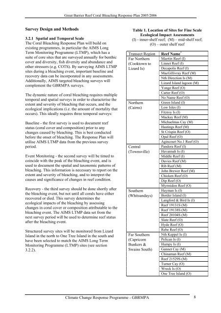
Structured survey sites will be monitored from Lizard<br />
Island in the north to One Tree Island in the south and<br />
have been selected to match the AIMS Long Term<br />
Monitoring Programme (LTMP) sites (see section<br />
3.2.2).<br />
Table 1. Location of Sites for Fine Scale<br />
Ecological Impact Assessments<br />
(I) - inner-shelf reef; (M) – mid-shelf reef;<br />
(O) – outer shelf reef<br />
Transect Region <strong>Reef</strong> Name *<br />
Far Northern Martin <strong>Reef</strong> (I)<br />
(Cooktown to Linnet <strong>Reef</strong> (I)<br />
Lizard Is) Decapolis <strong>Reef</strong> (I)<br />
MacGillivray <strong>Reef</strong> (M)<br />
Nth Direction Is (M)<br />
Lizard Island lagoon (M)<br />
Yonge <strong>Reef</strong> (O)<br />
Carter <strong>Reef</strong> (O)<br />
No Name <strong>Reef</strong> (O)<br />
Northern Green Island (I)<br />
(Cairns)<br />
Low Isles (I)<br />
Fitzroy Is (I)<br />
Mackay <strong>Reef</strong> (M)<br />
Michaelmas Cay (M)<br />
Hastings <strong>Reef</strong> (M)<br />
St Crispin <strong>Reef</strong> (O)<br />
Opal <strong>Reef</strong> (O)<br />
Agincourt No.1 <strong>Reef</strong> (O)<br />
Central<br />
Pandora <strong>Reef</strong> (I)<br />
(Townsville) Havannah Is (I)<br />
Middle <strong>Reef</strong> (I)<br />
Davies <strong>Reef</strong> (M)<br />
Rib <strong>Reef</strong> (M)<br />
John Brewer <strong>Reef</strong> (M)<br />
Chicken <strong>Reef</strong> (O)<br />
Dip <strong>Reef</strong> (O)<br />
Myrmidon <strong>Reef</strong> (O)<br />
Southern Hayman Is (I)<br />
(Whitsundays) Border Island (I)<br />
Langford & Bird Is (I)<br />
<strong>Reef</strong> 19131S (M)<br />
<strong>Reef</strong> 19138S (M)<br />
<strong>Reef</strong> 20104S (M)<br />
Slate <strong>Reef</strong> (O)<br />
Hyde <strong>Reef</strong> (O)<br />
Rebe <strong>Reef</strong> (O)<br />
Far Southern Nth Keppel Is (I)<br />
(Capricorn Pelican Is (I)<br />
Bunkers & Humpy Is (I)<br />
Swains South) Gannet Cay (M)<br />
Chinaman <strong>Reef</strong> (M)<br />
<strong>Reef</strong> 21529S (M)<br />
Turner Cay (O)<br />
Wreck Is (O)<br />
One Tree Island (O)<br />
Climate Change <strong>Response</strong> Programme - GBRMPA 8