

Municipality Climate Adaptation Case Study Report
Municipality Climate Adaptation Case Study Report
Municipality Climate Adaptation Case Study Report

Create successful ePaper yourself
Turn your PDF publications into a flip-book with our unique Google optimized e-Paper software.
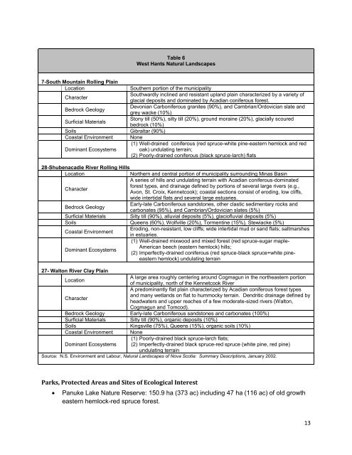
Table 6<br />
West Hants Natural Landscapes<br />
7-South Mountain Rolling Plain<br />
Location<br />
Southern portion of the municipality<br />
Character<br />
Southwardly inclined and resistant upland plain characterized by a variety of<br />
glacial deposits and dominated by Acadian coniferous forest.<br />
Bedrock Geology<br />
Devonian Carboniferous granites (90%), and Cambrian/Ordovician slate and<br />
grey wacke (10%)<br />
Surficial Materials<br />
Stony till (50%), silty till (20%), ground moraine (20%), glacially scoured<br />
bedrock (10%)<br />
Soils Gibraltar (90%)<br />
Coastal Environment None<br />
(1) Well-drained coniferous (red spruce-white pine-eastern hemlock and red<br />
Dominant Ecosystems oak) undulating terrain;<br />
(2) Poorly-drained coniferous (black spruce-larch) flats<br />
28-Shubenacadie River Rolling Hills<br />
Location<br />
Northern and central portion of municipality surrounding Minas Basin<br />
A series of hills and undulating terrain with Acadian coniferous-dominated<br />
forest types, and drainage defined by portions of several large rivers (e.g.,<br />
Character<br />
Avon, St. Croix, Kennetcook); coastal sections consist of eroding, low cliffs,<br />
wide intertidal flats and several large estuaries.<br />
Early-late Carboniferous sandstones, other clastic sedimentary rocks and<br />
Bedrock Geology<br />
carbonates (95%), and Cambrian/Ordovician slates (5%)<br />
Surficial Materials Silty till (90%), alluvial deposits (5%), glaciofluvial deposits (5%)<br />
Soils Queens (60%), Wolfville (20%), Tormentine (15%), Stewiacke (5%)<br />
Eroding, non-resistant, low cliffs; wide intertidal mud or sand flats; saltmarshes<br />
Coastal Environment<br />
in estuaries.<br />
(1) Well-drained mixwood and mixed forest (red spruce-sugar maple-<br />
American beech (eastern hemlock) hills;<br />
Dominant Ecosystems<br />
(2) Imperfectly-drained coniferous (red spruce-black spruce+white pineeastern<br />
hemlock) undulating terrain<br />
27- Walton River Clay Plain<br />
A large area roughly centering around Cogmagun in the northeastern portion<br />
Location<br />
of municipality, north of the Kennetcook River<br />
A predominantly flat plain characterized by Acadian coniferous forest types<br />
and many wetlands on flat to hummocky terrain. Dendritic drainage defined by<br />
Character<br />
headwaters and upper reaches of a few moderate-sized rivers (Walton,<br />
Cogmagun and Tomcod).<br />
Bedrock Geology Early-late Carboniferous sandstones and carbonates (100%)<br />
Surficial Materials Silty till (90%), organic deposits (10%)<br />
Soils Kingsville (75%), Queens (15%), organic soils (10%)<br />
Coastal Environment None<br />
(1) Poorly-drained black spruce-larch flats;<br />
Dominant Ecosystems (2) Imperfectly-drained black spruce-red spruce (white pine, red pine)<br />
undulating terrain<br />
Source: N.S. Environment and Labour, Natural Landscapes of Nova Scotia: Summary Descriptions, January 2002.<br />
Parks, Protected Areas and Sites of Ecological Interest<br />
<br />
Panuke Lake Nature Reserve: 150.9 ha (373 ac) including 47 ha (116 ac) of old growth<br />
eastern hemlock-red spruce forest.<br />
13


