

Municipality Climate Adaptation Case Study Report
Municipality Climate Adaptation Case Study Report
Municipality Climate Adaptation Case Study Report

You also want an ePaper? Increase the reach of your titles
YUMPU automatically turns print PDFs into web optimized ePapers that Google loves.
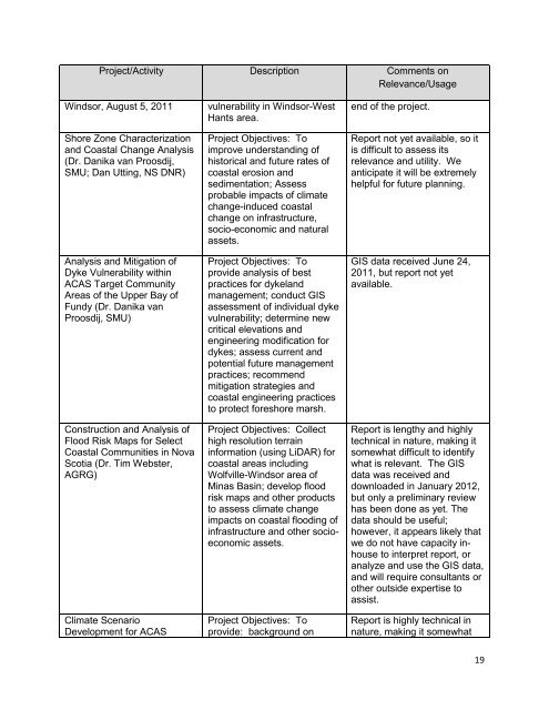
Project/Activity Description Comments on<br />
Relevance/Usage<br />
Windsor, August 5, 2011<br />
Shore Zone Characterization<br />
and Coastal Change Analysis<br />
(Dr. Danika van Proosdij,<br />
SMU; Dan Utting, NS DNR)<br />
Analysis and Mitigation of<br />
Dyke Vulnerability within<br />
ACAS Target Community<br />
Areas of the Upper Bay of<br />
Fundy (Dr. Danika van<br />
Proosdij, SMU)<br />
Construction and Analysis of<br />
Flood Risk Maps for Select<br />
Coastal Communities in Nova<br />
Scotia (Dr. Tim Webster,<br />
AGRG)<br />
<strong>Climate</strong> Scenario<br />
Development for ACAS<br />
vulnerability in Windsor-West<br />
Hants area.<br />
Project Objectives: To<br />
improve understanding of<br />
historical and future rates of<br />
coastal erosion and<br />
sedimentation; Assess<br />
probable impacts of climate<br />
change-induced coastal<br />
change on infrastructure,<br />
socio-economic and natural<br />
assets.<br />
Project Objectives: To<br />
provide analysis of best<br />
practices for dykeland<br />
management; conduct GIS<br />
assessment of individual dyke<br />
vulnerability; determine new<br />
critical elevations and<br />
engineering modification for<br />
dykes; assess current and<br />
potential future management<br />
practices; recommend<br />
mitigation strategies and<br />
coastal engineering practices<br />
to protect foreshore marsh.<br />
Project Objectives: Collect<br />
high resolution terrain<br />
information (using LiDAR) for<br />
coastal areas including<br />
Wolfville-Windsor area of<br />
Minas Basin; develop flood<br />
risk maps and other products<br />
to assess climate change<br />
impacts on coastal flooding of<br />
infrastructure and other socioeconomic<br />
assets.<br />
Project Objectives: To<br />
provide: background on<br />
end of the project.<br />
<strong>Report</strong> not yet available, so it<br />
is difficult to assess its<br />
relevance and utility. We<br />
anticipate it will be extremely<br />
helpful for future planning.<br />
GIS data received June 24,<br />
2011, but report not yet<br />
available.<br />
<strong>Report</strong> is lengthy and highly<br />
technical in nature, making it<br />
somewhat difficult to identify<br />
what is relevant. The GIS<br />
data was received and<br />
downloaded in January 2012,<br />
but only a preliminary review<br />
has been done as yet. The<br />
data should be useful;<br />
however, it appears likely that<br />
we do not have capacity inhouse<br />
to interpret report, or<br />
analyze and use the GIS data,<br />
and will require consultants or<br />
other outside expertise to<br />
assist.<br />
<strong>Report</strong> is highly technical in<br />
nature, making it somewhat<br />
19


