

Municipality Climate Adaptation Case Study Report
Municipality Climate Adaptation Case Study Report
Municipality Climate Adaptation Case Study Report

Create successful ePaper yourself
Turn your PDF publications into a flip-book with our unique Google optimized e-Paper software.
NOVA SCOTIA ATLANTIC CLIMATE ADAPTATIONS<br />
SOLUTIONS PROJECT<br />
MUNICIPALITY OF THE DISTRICT OF WEST HANTS<br />
<strong>Municipality</strong> <strong>Climate</strong> <strong>Adaptation</strong> <strong>Case</strong> <strong>Study</strong> <strong>Report</strong><br />
Prepared by<br />
Lynn Davis, MCIP, LPP<br />
Director of Planning<br />
30 March 2012
Disclaimer<br />
This publication is not to be used without permission, and any unauthorized use is strictly<br />
prohibited. ACASA, the authors, the provinces of Nova Scotia, New Brunswick, Prince Edward<br />
Island, Newfoundland and Labrador, and the Regional <strong>Adaptation</strong> Collaborative are not<br />
responsible for any unauthorized use that may be made of the information contained therein.<br />
The opinions expressed in this publication do not necessarily reflect those of ACASA, its<br />
associated provinces, or other partners of the Regional <strong>Adaptation</strong> Collaborative.<br />
Acknowledgements<br />
Thanks are extended to Tracy Robinson, Planning Technician, who was responsible for<br />
preparing the maps contained in this report, and to Rosalyn Graham, GIS Technician, who<br />
conducted a preliminary review of GIS data received from the researchers. Thanks also to the<br />
other members of the senior management team of the <strong>Municipality</strong> of the District of West<br />
Hants—Chief Administrative Officer Cheryl Chislett, Director of Finance Jerry Wood, Director of<br />
Public Works Rick Sherrard and Director of Recreation Kathy Kehoe—for providing information<br />
and comments on this report from their departmental perspectives.<br />
The <strong>Municipality</strong> of the District of West Hants is pleased to have had the opportunity to be<br />
involved as a municipal partner in the ACAS program and would like to thank all of the<br />
researchers involved in the Minas Basin project. The <strong>Municipality</strong> is also grateful to Will Green<br />
and Dan Walmsley of the <strong>Climate</strong> Change Directorate of Nova Scotia Environment for their<br />
efforts throughout the project.<br />
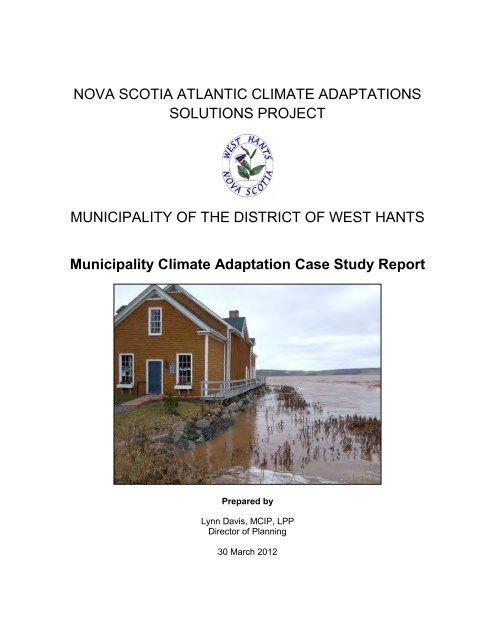
Cover Photo<br />
High Tide at Avon River Heritage Museum, Avondale<br />
Courtesy of Don Aldous
Executive Summary<br />
The <strong>Municipality</strong> of the District of West Hants is a municipal partner in the Atlantic <strong>Climate</strong><br />
<strong>Adaptation</strong>s Solutions (ACAS) program, one of the main aims of which is to stimulate climate<br />
change adaptation planning and decision-making. This case study report has been prepared as<br />
part of West Hants’ contribution to the ACAS program.<br />
West Hants is a primarily rural municipality covering 1,238 km 2 in the central part of mainland<br />
Nova Scotia. With a population of about 14,000, much of the development is concentrated near<br />
the Minas Basin coastline and the Avon River estuary. The municipality’s geography and<br />
historical settlement pattern contribute to its vulnerability to the impacts of climate change. In all,<br />
West Hants has more than 160 km of coastline, over 2,400 ha of dykeland and 30.5 km of<br />
running dyke at risk from sea level rise or storm surge. The potential for more frequent and<br />
severe freshwater flooding during high precipitation events is intensified by the operations of the<br />
tide gates at the Avon River Causeway and the upstream hydroelectric dams.<br />
Several climate change issues have been identified that are of concern to West Hants. Coastal<br />
erosion as a result of storm surges is an issue along the entire Minas Basin coastline where<br />
some areas already have lost substantial foreshore. Although flooding of dykelands along the<br />
tidal rivers occurs periodically, overtopping or breaching of dykes is far less common. Sea level<br />
rise and more frequent or severe storm surges will increase the risk and extent of flooding.<br />
Dyke structures and the Avon River Causeway’s tide gates are under provincial jurisdiction, but<br />
the municipality wishes to be certain that design, construction and maintenance of these<br />
structures takes into account climate change impacts. West Hants residents could also be<br />
affected by dykeland flooding outside the municipal boundaries. Of particular concern is the<br />
potential for road access to the hospital and high school in the neighbouring Town of Windsor to<br />
be cut off in the event of severe flooding.<br />
Existing problems with inland flooding in developed and developing areas will increase as<br />
extreme storms and precipitation events become more frequent. There is also a risk of serious<br />
flooding of homes and infrastructure if the dams which are part of the Avon and St. Croix River<br />
hydroelectric systems become compromised.<br />
Predicted drier summers could affect municipal treated water and individual well water supplies<br />
and increase forest fire risk. Many residents who rely on individual wells already experience<br />
water shortages. Ensuring the safety and sustainability of the three municipal drinking water<br />
supply watersheds in West Hants and protecting potential sources of drinking water is critical.<br />
West Hants has identified a number of possible climate adaptation projects and activities.<br />
These range from coastal and freshwater planning studies to infrastructure risk assessments,<br />
storm water management and water conservation programs. The research reports and GIS<br />
data resulting from the ACAS program will be a useful resource for many of these projects. The<br />
challenge for the municipality will be in interpreting and analyzing the technical and scientific<br />
research. With limited in-house resources and capacity, it will be difficult to move on to the next<br />
step of implementing policy and regulatory changes.<br />
ii
Contents<br />
Executive Summary ................................................................................................................................... ii<br />
1. Introduction .......................................................................................................................................... 1<br />
2. Description and Background ................................................................................................................. 1<br />
2.1 Geography ..................................................................................................................................... 1<br />
Avon River Causeway .................................................................................................................... 3<br />
Hydroelectric Development .......................................................................................................... 5<br />
2.2 Development and History ............................................................................................................. 5<br />
History ........................................................................................................................................... 5<br />
Development Today ...................................................................................................................... 6<br />
2.3 Economic ....................................................................................................................................... 8<br />
2.4 Social ........................................................................................................................................... 10<br />
Population ................................................................................................................................... 10<br />
Age ............................................................................................................................................... 11<br />
Dwellings and Households ........................................................................................................... 11<br />
Income ......................................................................................................................................... 11<br />
Place of Work .............................................................................................................................. 12<br />
2.5 Environment................................................................................................................................ 12<br />
Natural Landscapes ..................................................................................................................... 12<br />
Parks, Protected Areas and Sites of Ecological Interest .............................................................. 13<br />
<strong>Climate</strong> ......................................................................................................................................... 14<br />
2.6 <strong>Municipality</strong> ................................................................................................................................ 15<br />
Council ......................................................................................................................................... 15<br />
Employees ................................................................................................................................... 15<br />
Financial ....................................................................................................................................... 15<br />
3. <strong>Climate</strong> Change and <strong>Adaptation</strong> Issues .............................................................................................. 16<br />
iii
4. ACAS- Related Inputs and Activities .................................................................................................... 18<br />
5. Proposed <strong>Climate</strong> <strong>Adaptation</strong> Activities ............................................................................................. 21<br />
6. Conclusions and Lessons Learned ....................................................................................................... 23<br />
7. Bibliography ........................................................................................................................................ 25<br />
iv
1. Introduction<br />
The <strong>Municipality</strong> of the District of West Hants is a primarily rural municipality located about<br />
halfway between Halifax and Kentville. Development is concentrated around the Town of<br />
Windsor in Three Mile Plains and Falmouth, and in communities near Highway 101. The<br />
proximity to Halifax and the relatively lower cost of housing have contributed to the<br />
attractiveness of the area as a bedroom community for commuters who work in the Halifax<br />
Metro area. This has meant that West Hants has continued to see new residential development<br />
and modest growth in population, unlike many other areas of Nova Scotia that have<br />
experienced population decline over the past 15 to 20 years.<br />
The municipality’s geography and historical settlement pattern contribute to its vulnerability to<br />
the impacts of climate change. With more than 160 km of shoreline, over 2,400 ha of dykeland,<br />
and development concentrated near the Minas Basin coastline and tidal rivers, the risk of<br />
increased flooding and erosion as a result of sea level rise or storm surge is a real concern.<br />
The potential for more frequent and severe freshwater flooding during high precipitation events<br />
is a threat that is intensified by the operations of the Avon River Causeway tide gates and the<br />
upstream hydroelectric system dams.<br />
Finding ways to adapt to or mitigate climate change impacts will be an ongoing challenge for the<br />
municipality in the future. As a start to that process, West Hants has participated as a municipal<br />
partner in the Atlantic <strong>Climate</strong> <strong>Adaptation</strong>s Solutions (ACAS) program, one of the main aims of<br />
which is to stimulate climate change adaptation planning and decision-making. This case study<br />
report has been prepared as part of West Hants’ contribution to the ACAS program. The report<br />
provides an overview of the municipality in terms of its physical, ecological, social, economic<br />
and management makeup; climate change issues of importance; an evaluation of ACAS<br />
research projects and activities; identification of existing and proposed climate adaptation<br />
projects and activities that may be considered by the West Hants; identification of limits or<br />
restrictions to implementing those projects; and overall conclusions and lessons learned from<br />
the ACAS program.<br />
2. Description and Background<br />
2.1 Geography<br />
The <strong>Municipality</strong> of the District of West Hants covers 1,238 km 2 (305,945 ac) in the central part<br />
of mainland Nova Scotia. The shores of the Minas Basin form the northern boundary. To the<br />
east, West Hants is bordered by the <strong>Municipality</strong> of the District of East Hants. Halifax Regional<br />
<strong>Municipality</strong> and District of Chester lie to the south, with the County of Kings and the Town of<br />
Hantsport to the west. The Town of Windsor, located at the confluence of the Avon and St.<br />
Croix rivers, is bordered by West Hants on three sides (see Map 1 - Location and Relief).<br />
1
Map 1<br />
Location and Relief<br />
Prepared by:<br />
West Hants<br />
Planning Department<br />
February 2012<br />
Minas<br />
Basin<br />
District of East<br />
Hants<br />
Highway 215<br />
Cogmagun River<br />
Town of<br />
Hantsport<br />
Kennetcook River<br />
County of<br />
Kings<br />
Avon<br />
River<br />
Highway 101<br />
Town of<br />
Windsor<br />
St. Croix River<br />
Highway 14<br />
Highway 1<br />
Highway 14<br />
District of West<br />
Hants<br />
Highway 101<br />
District of<br />
Chester<br />
Halifax Regional<br />
<strong>Municipality</strong><br />
±<br />
Base data derived from the<br />
Nova Scotia Property Records<br />
Database (NSPRD), Copyright<br />
Her Majesty The Queen in Right<br />
of the Province of Nova Scotia.<br />
Km<br />
0 1 2 4 6 8 10<br />
1:250,000
Although primarily rural, West Hants has two urbanized areas—Three Mile Plains and<br />
Falmouth—located near the boundaries of the Town of Windsor. Both have been recognized as<br />
Growth Centres in the West Hants Municipal Planning Strategy. Other settlement consists of<br />
village and hamlet communities, cottage development primarily around lakes in the southern<br />
part of the municipality, and farms and other more scattered rural development in resource<br />
areas. The Town of Windsor represents the main service centre for residents of West Hants,<br />
offering grocery stores and other retail, government offices, a regional high school, and medical<br />
facilities including a hospital, doctors’ offices, pharmacies and ambulance service.<br />
The municipality is divided into two main physiographic regions. A lowland plain extends from<br />
the north in a wide arc around the Minas Basin and the Avon River, ending south of Windsor<br />
where it meets the upland plain near Martock. 1 Much of the lowland plain has an elevation of<br />
around 100 to 250 feet above sea level. 2 The upland plain covers the entire southern part of the<br />
municipality and has an elevation of about 400 to 500 feet above sea level. 3<br />
The central part of the municipality is bisected by the Avon River which has its headwaters in<br />
the upland plain and discharges into the Minas Basin. The Avon’s principal tributaries are the St.<br />
Croix, Kennetcook and Cogmagun rivers. The lower part of the Avon River valley is submerged<br />
and forms a wide tidal estuary extending into the tributaries. The estuaries are bordered by<br />
marshland, some of which is dyked. These dyked marshlands, which are below sea level, make<br />
up approximately 2,436 ha (6,019 ac), or about two percent of the total land area of West Hants.<br />
Dykelands are found along the flood plains of the Avon, St. Croix, Kennetcook, Herbert and<br />
Meander Rivers (see Map 2 - Dykeland). The Nova Scotia Department of Agriculture maintains<br />
30.5 km of running dyke in West Hants. 4 In all, West Hants has approximately 164 km of<br />
shoreline with potential for exposure to sea level rise.<br />
Several other features are important to the geography of West Hants and an understanding of<br />
potential flood risk. These include the Avon River Causeway on Highway 101 at Falmouth and<br />
the hydroelectric developments on the Avon and St. Croix River systems.<br />
Avon River Causeway<br />
Dykelands in West Hants fall into two categories—those protected from tidal flooding in the<br />
traditional fashion by dykes, and those upriver of the Avon River Causeway (approximately<br />
1,214 ha or 3,000 ac) which are protected by the causeway itself, rather than by dykes.<br />
Because of the security offered by the causeway since its construction in 1971, many of the<br />
dykes on marshlands south of the causeway on the Avon and West Branch Avon River were<br />
leveled, allowing farmers to use all of the land up to the river banks. The causeway acts as a<br />
significant constraint in the release of flood water from the Avon River system into the Minas<br />
1 D.B. Cann, Soil Survey of Hants County, p. 8.<br />
2 Cann, p. 11.<br />
3 Cann, p. 12.<br />
4 K. Carroll, Aboiteau Superintendent, NS Agriculture, pers. comm., 2011.<br />
3
Map 2<br />
Dykeland<br />
Prepared by:<br />
West Hants<br />
Planning Department<br />
February 2012<br />
Dykeland<br />
Cogmagun River<br />
Kennetcook River<br />
Avon<br />
River<br />
St. Croix River<br />
Windsor<br />
±<br />
Base data derived from the<br />
Nova Scotia Property Records<br />
Database (NSPRD), Copyright<br />
Her Majesty The Queen in Right<br />
of the Province of Nova Scotia.<br />
This map is a graphical representation of<br />
property boundaries which approximate the<br />
size, configuration, and location of parcels.<br />
This map is not a land survey and is not<br />
intended to be used for legal descriptions<br />
or to calculate exact dimensions or area.<br />
Km<br />
0 0.5 1 2 3 4 5<br />
1:90,000
Basin, with the only outlet for this water being through two gates which are opened at 12-hour<br />
intervals, coinciding with each tide cycle. The combination of several events, such as a major<br />
water runoff event upstream coupled with a mechanical or power failure making it impossible to<br />
open the gates, could trigger serious flooding. 5<br />
Hydroelectric Development<br />
Nova Scotia Power operates the Avon Hydro System which includes two hydroelectric stations<br />
on the Avon River with a series of upstream dams and reservoirs in the lake system in the<br />
southwestern part of the municipality. The Emergency Preparedness Plan (EPP) for Avon<br />
Hydro System describes potential flooding as a result of dam breaches or structural failures, as<br />
well as severe storms. The operation of this system further intensifies the flood risk potential for<br />
the dykelands above the causeway, as well as other low-lying areas in the floodplain.<br />
Minas Basin Pulp and Power Company Ltd. is responsible for the St. Croix River System which<br />
includes two generating plants with dams on the St. Croix River and Big St. Margaret’s Bay<br />
Lake. The main storage is behind Upper St. Croix Dam which impounds water in Panuke Lake,<br />
a 30- kilometer-long lake extending from the community of St. Croix south to the Halifax<br />
Regional <strong>Municipality</strong> boundary. The EPP for the St. Croix River System explains the flood risk<br />
potential for dykelands on the St. Croix River, as well as other low-lying areas in the<br />
communities of St. Croix, Newport Station, Ellershouse and Three Mile Plains, as a result of<br />
dam breaches or severe storms.<br />
2.2 Development and History<br />
History<br />
The <strong>Municipality</strong> of the District of West Hants was incorporated in 1879; however, settlement of<br />
the area began long before that. The early inhabitants were the Mi’kmaq. The French Acadians<br />
began to settle in the Avon Valley around 1685, coming from Les Mines in what is now Kings<br />
County. The Acadians were farmers and first built the dykes and aboiteaux that allowed the<br />
marshlands along the Avon, St. Croix and Kennetcook rivers to be farmed. By 1714, 53 families<br />
with 337 members were living in the area. By 1731, the number had increased to 150 families,<br />
and by 1748, as many as 2,700 Acadians had settled in the Avon Valley “from the ‘forks’ of the<br />
Avon River to Mount Denson, on the banks of the Minas Channel”. 6<br />
With the construction of Fort Edward at Pisiquid (Windsor) in 1750, the British presence began<br />
to be felt more strongly in the area. The original Mi’kmaq and Acadian trail from Windsor to<br />
Halifax was upgraded and used as a military road connecting Fort Edward and Fort Sackville, at<br />
the head of the Bedford Basin. 7 Following the deportation of the Acadians in 1755, the area<br />
was resettled, mainly by English settlers. The New England Planters arrived in Windsor in<br />
5 West Hants Planning Department, Non-farm Development on Dykelands, pp. 1-3.<br />
6 G. Shand, Historic Hants County, p. 7.<br />
7 J. Dawson, Nova Scotia’s Lost Highways, p.3.<br />
5
1760, settling in Falmouth, Newport Landing, Windsor Forks and Brooklyn. According to Joan<br />
Dawson in Nova Scotia’s Lost Highways, the Planters “quickly developed the area, forming<br />
towns and villages and building churches, roads and schools.” 8 The Planters were followed in<br />
1783 by the United Empire Loyalists.<br />
By the early 1800s, Windsor had become “an important destination for travelers from Halifax.” 9<br />
The most direct route was the original military road. The first stagecoach route in Nova Scotia<br />
was established on this road in 1816, and by then:<br />
…settlers’ homes were scattered all along the road… In some areas along the Windsor<br />
Road, communities were beginning to take shape. Individuals applied for and received<br />
land grants, which they hoped would provide for their needs. They built houses and<br />
cleared their land for what, at first was largely subsistence farming. With subsidies from<br />
the legislature, inns were established at intervals to serve passing travellers. 10<br />
Development Today<br />
The development pattern in West Hants today reflects to a large degree the early settlement of<br />
the area, with much of the development occurring near the Minas Basin and Avon River,<br />
especially in communities close to Windsor such as Falmouth and Three Mile Plains (see Map 3<br />
– Settlement Pattern). The communities that began with the early settlers’ land holdings on the<br />
old military road between Windsor and Halifax have continued to grow and spread out in a linear<br />
fashion following what is now Highway 1.<br />
With the construction of the controlled access Highway 101 in the early 1970s, the region<br />
became even more accessible to Halifax and residential development increased near the<br />
highway interchanges and along the Highway 101 corridor. The community of Falmouth, on the<br />
west side of the Avon River, grew dramatically, and as a result, in 1976, was the first area of<br />
West Hants to have land use planning and zoning. Planning for the Highway 101 corridor area<br />
from the East Hants boundary to Windsor soon followed in 1982. By 1989, planning documents<br />
had been approved for the primarily agricultural area of Upper Falmouth. Planning reached the<br />
more rural remainder of West Hants in 1994 when the first Municipal Planning Strategy and<br />
Land Use By-law were adopted for the area north of the Kennetcook River and the<br />
southwestern part of the municipality.<br />
Ongoing highway upgrades, resulting in a fully twinned Highway 101 between Halifax Region<br />
and Garlands Crossing by 2010, have continued to improve access to West Hants and increase<br />
the attractiveness of the area for residential development. The current planning documents,<br />
8 West Hants Historical Society website www.westhantshistorical society.ca, History of Hants County.<br />
9 Dawson, p. 6.<br />
10 Dawson, p. 6.<br />
6
Map 3<br />
Settlement Pattern Map<br />
Prepared by:<br />
West Hants<br />
Planning Department<br />
February 2012<br />
Minas<br />
Basin<br />
District of East<br />
Hants<br />
Highway 215<br />
Town of<br />
Hantsport<br />
Cogmagun River<br />
Kennetcook River<br />
County of<br />
Kings<br />
Avon<br />
River<br />
Highway 101<br />
Falmouth<br />
Town of<br />
Windsor<br />
St. Croix River<br />
Highway 14<br />
Three Mile<br />
Plains<br />
Highway 1<br />
Highway 101<br />
Highway 14<br />
District of<br />
Chester<br />
Halifax Regional<br />
<strong>Municipality</strong><br />
±<br />
Base data derived from the<br />
Nova Scotia Property Records<br />
Database (NSPRD), Copyright<br />
Her Majesty The Queen in Right<br />
of the Province of Nova Scotia.<br />
Km<br />
0 1 2 4 6 8 10<br />
1:250,000
adopted in 2008, apply to the entire municipality and encourage the majority of growth to occur<br />
in two Growth Centres (Falmouth and Three Mile Plains) which are serviced with municipal<br />
water and sewer. Rural development is to be focused in village and hamlet designations, while<br />
resource land, particularly agricultural land, is protected.<br />
The continuation of the historical development pattern—with roads and buildings following the<br />
Minas Basin coastline and the tidal rivers—means that a considerable amount of infrastructure<br />
is exposed to potential flooding as a result of sea level rise. To some extent, though, West<br />
Hants has been able to avoid the sort of large-scale residential and commercial development on<br />
dykeland that has taken place in other parts of Nova Scotia. This is in part related to the<br />
historical value of this land for agriculture and its ongoing use for crop production. In the late<br />
1990s, however, with development pressure growing, some dykeland began to be converted to<br />
residential use. To counteract this trend, in March 2001, Municipal Council approved changes to<br />
the planning documents that prohibited the construction of new main buildings on this land. As<br />
a result, no development has occurred on dykeland since that time. Of the 2,436 ha (6,000 ac)<br />
of dykeland in West Hants, only about 64 ha (159 ac) 11 has been used for non-farm<br />
development. Development has taken place, however, close to the identified boundaries of the<br />
dykelands, making that development also vulnerable to flooding as a result of sea level rise or<br />
storm surge. In addition, dykeland flooding outside the municipal boundaries has the potential<br />
to affect West Hants residents, many of whom rely on facilities and services in the neighbouring<br />
town of Windsor. Of particular concern is the potential for road access to the hospital and high<br />
school to be cut off in the event of severe flooding.<br />
2.3 Economic<br />
Historically, farming, lumbering, gypsum quarrying and shipbuilding represented the main<br />
occupations for residents of West Hants. 12 Between 1840 and 1890, shipbuilding was a key<br />
contributor to the economy. Small communities such as Newport Landing and Kempt Shore,<br />
along with the larger towns of Windsor and Hantsport, were shipbuilding centres. 13 Gypsum<br />
quarrying was a major industry in West Hants from the late 1700s until 2011 when the last<br />
quarry, owned by Fundy Gypsum Company, closed down as a result of reduced demand for<br />
wall board in the United States housing market. The company had operated mines at Miller<br />
Creek and Wentworth Creek since 1924.<br />
Although still important to the West Hants economy, the resource sector had declined<br />
considerably by the 21st century, largely replaced by the service sector. As of the 2006<br />
Census, 14 business and other services employed 33 percent of the labour force (see Figure 1).<br />
11 Based on GIS calculation of the area that has received a variance or been exempted from the development<br />
provisions of the Agricultural Marshland Conservation Act.<br />
12 Shand, p. 3.<br />
13 Shand, p. 41.<br />
14 Except where otherwise indicated, all demographic and labour force statistics in this report are from Statistics<br />
Canada, 2006 Census of Canada.<br />
8
Figure 1 – Labour Force by Industry, 2006<br />
The construction sector<br />
accounted for almost 13 percent<br />
of the jobs in West Hants,<br />
followed by retail trade (11<br />
percent) and manufacturing (11<br />
percent), and health care and<br />
social services (10.2 percent).<br />
Agriculture and other resourcebased<br />
industries employed 7.4<br />
percent of the labour force.<br />
Educational services (6.2<br />
percent), wholesale trade (4.3<br />
percent) and finance and real<br />
estate (3.5 percent) also<br />
contributed to employment in the<br />
municipality.<br />
A Location Quotient calculation<br />
(see Table 1) indicates that<br />
West Hants has a higher<br />
proportion of its labour force in<br />
construction, agriculture and other resource industries, and transportation and warehousing<br />
industries than Canada as a whole, and is considered specialized in those sectors.<br />
Table 1<br />
Location Quotients > 1.0<br />
West Hants Industry Sectors Compared with Canada, 2006 Census<br />
Experienced Labour Force 15 years and<br />
over by Industry<br />
West Hants Canada Location<br />
Quotient<br />
Total 6,935 16,861,185<br />
Agriculture, forestry, fishing & hunting 335 523,650 1.6<br />
Mining and oil and gas extraction 145 238,815 1.5<br />
Construction 880 1,069,100 2.0<br />
Transportation & warehousing 395 820,195 1.2<br />
Note: Location Quotients were calculated by dividing the proportion of West Hants’ labour force in a particular industry by the<br />
proportion in the same industry nation-wide. A location quotient greater than 1.0 indicates a higher concentration of employment in<br />
that industry than the national average.<br />
Source: Data from Nova Scotia Community Counts web page, Statistics Canada, Census of Population, 2006.<br />
As of the 2006 Agricultural Census, there were 164 farms in West Hants, with a total of 225<br />
operators. These farms occupied 13,856 ha (34,238 acres), or about 11 percent of the total<br />
land area of the municipality. Gross farm receipts amounted to $17.5 million annually and total<br />
farm capital had a market value of $82.2 million.<br />
9
According to Human Resources and Skills Development Canada (HRSDC), major employers 15<br />
(with employment levels of 100 plus) in West Hants include: Ski Martock, Avon Valley Floral<br />
and Greenhouses and Cobham Tracking & Locating. HRSDC also lists as major employers<br />
covering the area, although not located within the municipal unit: Annapolis Valley District<br />
Health Authority, Annapolis Valley Regional School<br />
Board, CKF Inc., Minas Basin Pulp and Power,<br />
Dykeland Lodge, Hants Community Hospital and<br />
Sobeys Stores Ltd.<br />
Labour force indicators are set out in Table 2. The<br />
participation rate for West Hants in 2006 was 61.1<br />
percent, marginally lower than the provincial rate of<br />
62.9 percent. The unemployment rate was also<br />
lower than the provincial rate, 8.7 percent<br />
compared with 9.1 percent for Nova Scotia.<br />
2.4 Social<br />
Population<br />
Table 2<br />
Labour Force Indicators, 2006<br />
(% of total population 15 years and over)<br />
West Hants<br />
Nova Scotia<br />
Participation Rate 61.1 62.9<br />
Employment Rate 55.8 57.2<br />
Unemployment Rate 8.7 9.1<br />
Source: Statistics Canada, Census of Canada, 2006.<br />
In 2006, the population of West Hants was 13,881. The municipality’s rural nature is reflected in<br />
its population density, 11.2 persons per square kilometer, compared with 17.3 for the province.<br />
Unlike other areas of Nova Scotia with declining population, the municipality is part of the four<br />
central counties (Hants, Kings, Halifax, Colchester) that experienced population growth from<br />
1991 to 2006. 16 Between 1986 and 2006, the population of West Hants rose by four percent,<br />
similar to the rate experienced by the province of Nova Scotia as a whole (see Table 3). Figure<br />
2 illustrates the municipality’s population change during this period.<br />
Table 3<br />
Population of West Hants and Province of Nova Scotia<br />
1986-2006<br />
Figure 2 – Population Change, 1986-2006<br />
West Hants<br />
%<br />
%<br />
Nova Scotia<br />
Change<br />
Change<br />
1986 13,345 873,199<br />
1991 13,610 2.0 899,942 3.1<br />
1996 13,792 1.3 909,282 1.0<br />
2001 13,780 -0.1 908,007 -0.1<br />
2006 13,881 0.7 913,462 0.6<br />
Source: Statistics Canada, Census of Canada<br />
15 Email from TFW-LMI Enquiry Response Team, HRSDC, January 26, 2012.<br />
16 Service Nova Scotia & Municipal Relations, Patterns of Demographic Change, 2001-06, Presentation to NSPDA<br />
Conference, May 16, 2008.<br />
10
Age<br />
Like the rest of Nova Scotia and the country, West Hants’ population is getting older (see<br />
Figures 3 and 4). The median age in 2006 was 42.3 years, slightly higher than the provincial<br />
median age of 41.8. Almost 45 percent of West Hants residents were over the age of 44, with<br />
slightly more women than men. Seniors, age 65 or older, made up 14 percent of the population.<br />
In comparison, 15 percent of Nova Scotia’s population was 65 or older in 2006.<br />
Figure 3 – West Hants Age Distribution by Sex, 2006<br />
Figure 4 - West Hants Population by Age, 2006<br />
Dwellings and Households<br />
The majority (90 percent) of dwellings are owned rather than rented, and in 2006, 90.8 percent<br />
of the occupied private dwellings in the municipality were single detached houses. The average<br />
value of an owned dwelling in West Hants in 2006 was $134,281 while the provincial average<br />
value was $158,000.<br />
The average household size was 2.5 persons compared with 2.4 persons per household for<br />
Nova Scotia. Fewer people in West Hants live alone than in the province as a whole, although<br />
the number of one-person households is increasing. In 1996, 15.6 percent of West Hants<br />
households were occupied by only one person, but by 2006, that percentage had risen to 19<br />
percent, representing 1,035 households. In Nova Scotia, 27 percent of households had only a<br />
single occupant in 2006.<br />
Income<br />
Table 4 provides details of the level of<br />
after-tax income of West Hants residents<br />
in 2005 compared with the province as a<br />
whole. Median household income in<br />
West Hants ($40,818) was higher than<br />
the provincial median, while individual<br />
Table 4<br />
Median After Tax Income in 2005<br />
West Hants Nova Scotia<br />
Individual (persons 15 and over) $20,167 $20,778<br />
Household $40,818 $40,591<br />
Source: Statistics Canada, Census of Canada, 2006.<br />
11
income ($20,167) was slightly lower. Fewer West Hants families (7.6 percent) had low income<br />
status in 2006 than did families in the province as a whole (10.3 percent). 17<br />
Place of Work<br />
According to the 2006 Census, approximately 12 percent (745 people) of the West Hants<br />
employed labour force worked within the municipality itself (see Table 5). Another 420 people<br />
(7 percent) said they worked at home. About 36 percent (2,285) worked elsewhere in Hants<br />
County, and 31 percent (1,990) commuted to a different county for work, probably the<br />
neighbouring Halifax or Kings Counties.<br />
Table 5<br />
Place of Work Status, 2006<br />
(West Hants Employed Labour Force 15 years and over)<br />
Total %<br />
Worked at home 420 7<br />
Worked outside Canada 10 0<br />
No fixed workplace address 935 15<br />
Worked in census subdivision (municipality) of residence 745 12<br />
Worked in a different census subdivision (municipality) 2,285 36<br />
within the census division (county) of residence<br />
Worked in a different census division (county) 1,990 31<br />
Worked in a different province 35 1<br />
Total 6,415 100<br />
Source: Statistics Canada, Census of Canada, 2006.<br />
Most rely on a vehicle to get to<br />
work. In 2006, 96 percent used a<br />
car, truck or van, three percent<br />
walked and less than one percent<br />
said they used public transit. No<br />
formal public transit existed in<br />
West Hants prior to the fall of<br />
2007, when Kings Transit began<br />
operating a bus service in the<br />
municipality. Currently, the<br />
service runs every two hours from<br />
Monday to Saturday, and covers a<br />
route extending from Brooklyn to<br />
Wolfville.<br />
2.5 Environment<br />
Natural Landscapes<br />
The Protected Areas Branch of Nova Scotia Department of Environment and Labour lists 80<br />
distinct landscape types in Nova Scotia in Natural Landscapes of Nova Scotia. Landscapes<br />
are described as being “a mosaic of different but interacting ecosystems that are repeated in a<br />
similar pattern to form a distinct and definable land unit or area”. 18 The main natural landscapes<br />
found in West Hants are the South Mountain Rolling Plain, Shubenacadie River Rolling Hills and<br />
Walton River Clay Plain (see Table 6).<br />
17 Nova Scotia Department of Finance, Community Counts Web page.<br />
18 NS Dept. of Environment and Labour, Natural Landscapes of Nova Scotia: Summary Descriptions, p. 2.<br />
12
Table 6<br />
West Hants Natural Landscapes<br />
7-South Mountain Rolling Plain<br />
Location<br />
Southern portion of the municipality<br />
Character<br />
Southwardly inclined and resistant upland plain characterized by a variety of<br />
glacial deposits and dominated by Acadian coniferous forest.<br />
Bedrock Geology<br />
Devonian Carboniferous granites (90%), and Cambrian/Ordovician slate and<br />
grey wacke (10%)<br />
Surficial Materials<br />
Stony till (50%), silty till (20%), ground moraine (20%), glacially scoured<br />
bedrock (10%)<br />
Soils Gibraltar (90%)<br />
Coastal Environment None<br />
(1) Well-drained coniferous (red spruce-white pine-eastern hemlock and red<br />
Dominant Ecosystems oak) undulating terrain;<br />
(2) Poorly-drained coniferous (black spruce-larch) flats<br />
28-Shubenacadie River Rolling Hills<br />
Location<br />
Northern and central portion of municipality surrounding Minas Basin<br />
A series of hills and undulating terrain with Acadian coniferous-dominated<br />
forest types, and drainage defined by portions of several large rivers (e.g.,<br />
Character<br />
Avon, St. Croix, Kennetcook); coastal sections consist of eroding, low cliffs,<br />
wide intertidal flats and several large estuaries.<br />
Early-late Carboniferous sandstones, other clastic sedimentary rocks and<br />
Bedrock Geology<br />
carbonates (95%), and Cambrian/Ordovician slates (5%)<br />
Surficial Materials Silty till (90%), alluvial deposits (5%), glaciofluvial deposits (5%)<br />
Soils Queens (60%), Wolfville (20%), Tormentine (15%), Stewiacke (5%)<br />
Eroding, non-resistant, low cliffs; wide intertidal mud or sand flats; saltmarshes<br />
Coastal Environment<br />
in estuaries.<br />
(1) Well-drained mixwood and mixed forest (red spruce-sugar maple-<br />
American beech (eastern hemlock) hills;<br />
Dominant Ecosystems<br />
(2) Imperfectly-drained coniferous (red spruce-black spruce+white pineeastern<br />
hemlock) undulating terrain<br />
27- Walton River Clay Plain<br />
A large area roughly centering around Cogmagun in the northeastern portion<br />
Location<br />
of municipality, north of the Kennetcook River<br />
A predominantly flat plain characterized by Acadian coniferous forest types<br />
and many wetlands on flat to hummocky terrain. Dendritic drainage defined by<br />
Character<br />
headwaters and upper reaches of a few moderate-sized rivers (Walton,<br />
Cogmagun and Tomcod).<br />
Bedrock Geology Early-late Carboniferous sandstones and carbonates (100%)<br />
Surficial Materials Silty till (90%), organic deposits (10%)<br />
Soils Kingsville (75%), Queens (15%), organic soils (10%)<br />
Coastal Environment None<br />
(1) Poorly-drained black spruce-larch flats;<br />
Dominant Ecosystems (2) Imperfectly-drained black spruce-red spruce (white pine, red pine)<br />
undulating terrain<br />
Source: N.S. Environment and Labour, Natural Landscapes of Nova Scotia: Summary Descriptions, January 2002.<br />
Parks, Protected Areas and Sites of Ecological Interest<br />
<br />
Panuke Lake Nature Reserve: 150.9 ha (373 ac) including 47 ha (116 ac) of old growth<br />
eastern hemlock-red spruce forest.<br />
13
St. Croix River International Biological Program (IBP) Site: mixed forest on Karst<br />
topography; rare flora including Ram’s-head Lady Slipper (species listed as Endangered<br />
in the Nova Scotia Species at Risk Act).<br />
Akin Marsh: Eastern Habitat Joint Venture Site, Mount Denson.<br />
Falls Lake Provincial Park: 4.86 ha (12 ac) on Falls Lake, Vaughan.<br />
Smiley’s Provincial Park: 40.47 ha (100 ac) on Meander River, McKay Section.<br />
Cheverie Creek Salt Marsh Restoration Project: Highway 215, Cheverie.<br />
West Hants also includes three municipal drinking water supply watersheds within its<br />
boundaries, all of which rely on surface water. French Mill Brook, located west of Falmouth,<br />
consists of 1,139 ha (2,814 ac) designated as a Protected Water Area (PWA) under the Nova<br />
Scotia Environment Act. It provides treated water to the Falmouth Growth Centre. Mill Lakes,<br />
covering 1,778 ha (4,393 ac) south of Martock, also a designated PWA, supplies water to the<br />
Town of Windsor and the Three Mile Plains Growth Centre. The Town of Hantsport’s water<br />
supply is Davidson Lake, just west of French Mill Brook. Although not currently protected under<br />
the Environment Act, Hantsport is in the process of seeking the designation.<br />
<strong>Climate</strong><br />
Environment Canada compiles climate normals or averages from climate stations across<br />
Canada which can be used to describe the average climatic conditions of a particular location.<br />
Table 7 shows temperature and precipitation data for two stations in West Hants (Windsor-<br />
Martock and Summerville), along with the Mount Uniacke station just east of the municipal<br />
boundary.<br />
Table 7<br />
<strong>Climate</strong> Normals, 1971-2000<br />
Windsor-Martock, Summerville and Mount Uniacke <strong>Climate</strong> Stations<br />
Windsor-<br />
Martock<br />
Summerville*<br />
Mount<br />
Uniacke*<br />
Temperature – Annual<br />
Daily Average ( o C) 7.4 6.8 5.8<br />
Daily Maximum ( o C) 12.3 11.4 10.9<br />
Daily Minimum ( o C) 2.4 2.1 0.6<br />
Hot Days (max. temperature >30 o ) 5.1 0.76 1.8<br />
Days with min. temperature >0 o 215 210.4 190.3<br />
Growing Degree Days >5 o 1990.9 1808.2 1651.4<br />
Growing Degree Days >10 o 1061 913.3 814.2<br />
Precipitation – Annual<br />
Rainfall (mm) 1073.6 857.5 1282.7<br />
Snowfall (mm) 234.6 196.4 270.1<br />
Total Precipitation (mm) 1308.2 1054 1552.6<br />
Days with Rainfall (>=0.2 mm) 122.3 94.5 129.3<br />
Days with Snowfall (>=0.2 mm) 37.9 31 43.6<br />
Note: * Station meets World Meteorological Organization standards for temperature and precipitation.<br />
Source: Environment Canada: www.climate.weatheroffice.gc.ca/climate_normals/results_e.html?stnID=65...<br />
14
2.6 <strong>Municipality</strong><br />
Council<br />
West Hants Municipal Council consists of nine councillors, including a Warden and Deputy<br />
Warden chosen by councillors following each general election. Councillors are elected to<br />
represent the following polling districts:<br />
<br />
<br />
<br />
<br />
<br />
<br />
<br />
<br />
<br />
District 1: Summerville-Kempt<br />
District 2: Avondale-Burlingtons<br />
District 3: Brooklyn-Scotch Village<br />
District 4: Ste. Croix-Ellershouse<br />
District 5: Wentworth-Newport Corner-Newport Station<br />
District 6: Three Mile Plains<br />
District 7: Three Mile Plains-Martock<br />
District 8: Falmouth-Mount Denson<br />
District 9: Falmouth<br />
The municipality operates under a Council-Chief Administrative Officer system. Municipal<br />
Council and Committee of the Whole meet on a monthly basis. Planning Advisory Committee,<br />
which includes two citizen appointees as well as all nine councillors, meets as needed, usually<br />
six to eight times a year, to deal with land use planning and development matters.<br />
Employees<br />
West Hants has 25 employees based at three main work sites: Municipal Complex at 76<br />
Morison Drive, Windsor-West Hants Industrial Park; Falmouth Water Treatment Plant on<br />
Eldridge Road, Upper Falmouth; and Falmouth Wastewater Treatment Plant, located near Exit 8<br />
on Highway 101, Falmouth. There are no employees in climate and adaptation-related<br />
positions.<br />
Financial<br />
For the 2011-2012 fiscal year, the municipality’s<br />
general operating budget totalled $10 million.<br />
Protective services such as fire, police, law<br />
enforcement and building inspection accounted for<br />
the greatest proportion of expenditures (35<br />
percent), budgeted at $3.5 million) (see Figure 5).<br />
Approximately $2.4 million, or 24 percent of the<br />
budget, was allocated to education. General<br />
government services of $1.7 million represented 17<br />
percent, while environmental health services<br />
(sewage collection, refuse, recycling) of $1 million<br />
made up 11 percent of the operating budget.<br />
Environmental development services, recreation<br />
Figure 5 – Breakdown of General Operating Budget<br />
15
and transportation expenditures totaled $1.4 million, making up the remaining 14 percent of the<br />
total budget. Other municipal budget and financial information is set out in Table 8.<br />
Table 8<br />
Budget and Financial Information<br />
2011-2012<br />
General Operating Expenditures Budget<br />
$10,035,452<br />
Capital Five-year Plan $3,985,522<br />
Budget for Weather-related Repairs/Maintenance $41,000<br />
General Operating Income $9,819,963<br />
Infrastructure Value (as of March 31, 2011) $13,687,000<br />
Amount Invested in Infrastructure Renewal $3,600,000<br />
Debt (long-term) $3,600,000<br />
Residential Tax Rate (per $100 assessment) $0.91<br />
Commercial Tax Rate (per $100 assessment) $1.60<br />
Source: West Hants Finance Department, January 9, 2012.<br />
3. <strong>Climate</strong> Change and <strong>Adaptation</strong> Issues<br />
The following is an overview of the climate change issues that are considered to be important to<br />
the municipality.<br />
<strong>Climate</strong> Change and <strong>Adaptation</strong> Issues Important to West Hants<br />
Issue<br />
Coastal flooding<br />
Inland flooding<br />
Details<br />
Flooding of the dykelands along the tidal rivers in the<br />
municipality occurs periodically, most frequently during<br />
fall and winter when drainage ditches or aboiteaux<br />
become blocked with ice. Overtopping or breaching of<br />
dykes is less common, but sea level rise and storm<br />
surges increase the risk and potential extent of<br />
flooding. The risk to existing built-up areas (e.g.,<br />
Highway 1, Falmouth) is of most concern.<br />
Flooding at Avon River Heritage Museum, Avondale<br />
Flooding occurs periodically in low lying areas along<br />
West Branch Avon River from Wile Settlement to Mill<br />
Section (area affected by Nova Scotia Power’s Avon<br />
Hydro System) during high precipitation events (e.g.,<br />
April 2009)<br />
Lebreau Creek Brook frequently overtops its banks in<br />
heavy rains and runoff events (e.g., April 2009;<br />
November 2010), resulting in flooding of homes<br />
adjacent to the brook along Highway 1, near Panuke<br />
16
<strong>Climate</strong> Change and <strong>Adaptation</strong> Issues Important to West Hants<br />
Issue<br />
Details<br />
Road, Three Mile Plains.<br />
Erosion<br />
Saltwater intrusion<br />
Infrastructure<br />
Coastal erosion as a result of storm surges is a<br />
concern along the entire extent of Minas Basin<br />
coastline, from Avondale to Walton on the eastern side<br />
and from Mount Denson to Hantsport on the western<br />
side. Some areas, such as Hobart’s Beach in<br />
Summerville, are believed to have lost as much as 100<br />
feet of foreshore.<br />
Salt water encountered in drilled wells at two<br />
properties in Mantua<br />
Road wash outs as a result of severe storms; e.g.,<br />
Ashland Road, April 2009<br />
Periodic dykeland flooding that limits road access;<br />
e.g., Rocks Road, St. Croix; Falmouth Dyke Road,<br />
Upper Falmouth<br />
Critical infrastructure (Windsor) – potential for access<br />
to Hants Community Hospital and Avon View High<br />
School to be cut off as a result of flooding of Tregothic<br />
Marsh across Payzant Drive and Wentworth Road<br />
Dykes, aboiteaux and Avon River Causeway –<br />
concern over height of dykes and adequacy of<br />
maintenance in light of potential sea level rise,<br />
increased storm surge and extreme run-off events<br />
upstream<br />
Avon Hydro System and St. Croix River Hydroelectric<br />
System – potential for dam breaches and downstream<br />
flooding in severe storms; concern relates to adequacy<br />
of dam construction and emergency preparedness<br />
Falmouth Sewage Treatment Plant – potentially at risk<br />
from coastal flooding<br />
Existing provincial and municipal storm water<br />
infrastructure (ditches, culverts) – not designed to<br />
handle current storm water flows in extreme events;<br />
e.g., Falmouth Dyke Road flooding<br />
Municipal Water Treatment - In municipal water supply<br />
areas, drier summers could result in reduced water<br />
recharge and increased forest fire risk in the<br />
watersheds. The opposite is also a concern where<br />
extreme rain events could result in flash flooding. In<br />
both cases, there is potential for contamination of<br />
source water, making it more difficult, slower and more<br />
energy intensive to treat it to a potable standard.<br />
17
<strong>Climate</strong> Change and <strong>Adaptation</strong> Issues Important to West Hants<br />
Issue<br />
Drier Summers<br />
High Winds<br />
Capacity<br />
Details<br />
Reduced water supply – the majority of residents of<br />
West Hants, with the exception of those living in the<br />
two Growth Centres, depend on individual wells for<br />
their water supply; many already experience<br />
shortages, particularly in summer, and rely on water<br />
haulers to supplement their supply<br />
Increased forest fire risk is a concern, particularly in<br />
areas of increasing residential development in the<br />
southwestern part of the municipality.<br />
Extended power outages and damage to buildings and<br />
property as a result of hurricanes or high winds.<br />
Limited municipal staff, and few with expertise in<br />
climate change impacts and associated risk<br />
assessment, or technical skills in mapping and GIS<br />
applications needed to support such assessment.<br />
Limited municipal financial resources.<br />
4. ACAS- Related Inputs and Activities<br />
The following is a list of the ACAS activities and projects that have taken place during the period<br />
of the program that may have some relevance to the Minas Basin project area.<br />
Project/Activity Description Comments on<br />
Relevance/Usage<br />
Interactive Workshop for<br />
Minas Basin Area, held in<br />
Wolfville, June 21, 2011<br />
Presentation by Dr. Danika<br />
van Proosdij and St. Mary’s<br />
University students to staff of<br />
West Hants and Town of<br />
Briefing on ACAS program,<br />
deliverables and timelines and<br />
presentations by researchers<br />
giving an overview of projects<br />
currently underway in Minas<br />
Basin area.<br />
Briefing on research work to<br />
date related to shore zone<br />
characterization, flood<br />
inundation and dyke<br />
Since the program began in<br />
fall of 2009, this was the first<br />
briefing on the work the<br />
researchers had been doing<br />
and what products would be<br />
available at the end of the<br />
program. It was also useful to<br />
find out the requirements for<br />
the municipal reports which<br />
were due in nine months.<br />
Provided a good indication of<br />
the type of information that<br />
would be forthcoming at the<br />
18
Project/Activity Description Comments on<br />
Relevance/Usage<br />
Windsor, August 5, 2011<br />
Shore Zone Characterization<br />
and Coastal Change Analysis<br />
(Dr. Danika van Proosdij,<br />
SMU; Dan Utting, NS DNR)<br />
Analysis and Mitigation of<br />
Dyke Vulnerability within<br />
ACAS Target Community<br />
Areas of the Upper Bay of<br />
Fundy (Dr. Danika van<br />
Proosdij, SMU)<br />
Construction and Analysis of<br />
Flood Risk Maps for Select<br />
Coastal Communities in Nova<br />
Scotia (Dr. Tim Webster,<br />
AGRG)<br />
<strong>Climate</strong> Scenario<br />
Development for ACAS<br />
vulnerability in Windsor-West<br />
Hants area.<br />
Project Objectives: To<br />
improve understanding of<br />
historical and future rates of<br />
coastal erosion and<br />
sedimentation; Assess<br />
probable impacts of climate<br />
change-induced coastal<br />
change on infrastructure,<br />
socio-economic and natural<br />
assets.<br />
Project Objectives: To<br />
provide analysis of best<br />
practices for dykeland<br />
management; conduct GIS<br />
assessment of individual dyke<br />
vulnerability; determine new<br />
critical elevations and<br />
engineering modification for<br />
dykes; assess current and<br />
potential future management<br />
practices; recommend<br />
mitigation strategies and<br />
coastal engineering practices<br />
to protect foreshore marsh.<br />
Project Objectives: Collect<br />
high resolution terrain<br />
information (using LiDAR) for<br />
coastal areas including<br />
Wolfville-Windsor area of<br />
Minas Basin; develop flood<br />
risk maps and other products<br />
to assess climate change<br />
impacts on coastal flooding of<br />
infrastructure and other socioeconomic<br />
assets.<br />
Project Objectives: To<br />
provide: background on<br />
end of the project.<br />
<strong>Report</strong> not yet available, so it<br />
is difficult to assess its<br />
relevance and utility. We<br />
anticipate it will be extremely<br />
helpful for future planning.<br />
GIS data received June 24,<br />
2011, but report not yet<br />
available.<br />
<strong>Report</strong> is lengthy and highly<br />
technical in nature, making it<br />
somewhat difficult to identify<br />
what is relevant. The GIS<br />
data was received and<br />
downloaded in January 2012,<br />
but only a preliminary review<br />
has been done as yet. The<br />
data should be useful;<br />
however, it appears likely that<br />
we do not have capacity inhouse<br />
to interpret report, or<br />
analyze and use the GIS data,<br />
and will require consultants or<br />
other outside expertise to<br />
assist.<br />
<strong>Report</strong> is highly technical in<br />
nature, making it somewhat<br />
19
Project/Activity Description Comments on<br />
Relevance/Usage<br />
Communities in Nova Scotia<br />
(William Richards and Réal<br />
Daigle)<br />
An Assessment of Coastal<br />
Infrastructure Relevant to the<br />
Fishing and Aquaculture<br />
Industries in ACAS <strong>Study</strong><br />
Areas<br />
Economic and Demographic<br />
Scenarios for Nova Scotia and<br />
Some ACAS Community Pilot<br />
Areas<br />
Improving the Effectiveness of<br />
<strong>Climate</strong> Change and<br />
<strong>Adaptation</strong> Visualization<br />
Techniques Targeted<br />
Towards Decision-makers and<br />
Citizens (Dalhousie University<br />
School of Planning)<br />
Vulnerability of Coastal<br />
Aquifers to Seawater Intrusion<br />
in Nova Scotia (Grant<br />
Ferguson, St. FX University)<br />
technical issues involved in<br />
developing local climate<br />
scenarios; an approach for<br />
climate scenario development<br />
appropriate to NS and PEI; a<br />
suite of climate scenarios; a<br />
guide for developing climate<br />
scenarios to support provincial<br />
and local adaptation planning<br />
and decision making.<br />
Project Objectives: To<br />
provide economic and<br />
demographic background data<br />
and projections on range of<br />
potential outcomes from 2021<br />
to 2051 for NS ACAS pilot<br />
communities.<br />
Project Objectives: To<br />
investigate how different<br />
visualization methods affect<br />
understanding of sea level<br />
rise related to climate change<br />
and compare effectiveness of<br />
conventional map and air<br />
photos, 3D static terrain<br />
model, and digital 3D static<br />
model.<br />
Project Objectives: To assess<br />
vulnerability of coastal<br />
aquifers to seawater intrusion<br />
caused by climate change;<br />
characterize vulnerability at<br />
three case study locations;<br />
develop map indicating<br />
relative vulnerability of<br />
seawater intrusion throughout<br />
difficult to identify what is<br />
relevant or how to use the<br />
information. We will likely<br />
require outside expertise to<br />
assist in interpretation.<br />
<strong>Report</strong> not yet available, so<br />
difficult to assess whether the<br />
project will be useful or<br />
relevant.<br />
Fishing industry plays a very<br />
small role in economy of West<br />
Hants.<br />
<strong>Report</strong> not yet available, so<br />
difficult to assess whether the<br />
project will be useful or<br />
relevant.<br />
<strong>Report</strong> not yet available.<br />
<strong>Report</strong> not yet available.<br />
20
Project/Activity Description Comments on<br />
Relevance/Usage<br />
NS.<br />
Incorporating <strong>Climate</strong> change<br />
<strong>Adaptation</strong> into Emergency<br />
Planning at the Local Level in<br />
Nova Scotia<br />
Conference – <strong>Climate</strong><br />
Change: Getting Ready,<br />
March 5-6, 2012, Halifax<br />
Project Objectives: To work<br />
with ACAS partners to reassess<br />
emergency response<br />
plans based on new flood,<br />
erosion and sedimentation<br />
maps; review emergency<br />
legislation and regulations to<br />
make recommendations on<br />
changes to better manage<br />
impacts of climate change.<br />
A conference bringing<br />
together municipal ACAS<br />
partners, researchers and<br />
provincial and federal<br />
government officials to<br />
present and discuss the<br />
results of the ACAS Program<br />
in Nova Scotia.<br />
<strong>Report</strong> not yet available.<br />
The conference provided an<br />
opportunity to hear more<br />
detail on the various research<br />
projects. We were also able<br />
to connect with some of the<br />
researchers to begin<br />
coordinating a follow-up<br />
presentation for municipal<br />
council and knowledge<br />
transfer for municipal staff at a<br />
future date.<br />
5. Proposed <strong>Climate</strong> <strong>Adaptation</strong> Activities<br />
The following section lists possible climate adaptation projects and activities the <strong>Municipality</strong> of<br />
West Hants wishes to consider.<br />
Proposed Activity<br />
Coastal Zone Planning <strong>Study</strong><br />
Review MPS/LUB provisions<br />
related to dykeland<br />
Rationale, Objective and<br />
Description<br />
Identify non-dykeland areas at<br />
risk from coastal flooding or<br />
erosion, and land use<br />
planning methods (e.g.,<br />
setbacks, elevations, site<br />
design, environmental studies,<br />
etc.) to address development<br />
in these areas.<br />
Identify areas where extent of<br />
potential flooding has<br />
Comments on possible<br />
implementation and resources<br />
Required<br />
Requires scientific and<br />
technical (GIS, mapping)<br />
expertise<br />
Limited in-house resources<br />
D. van Proosdij’s and T.<br />
Webster’s work will help<br />
21
development<br />
Proposed Activity<br />
Freshwater and Riparian Zone<br />
Planning <strong>Study</strong><br />
Risk Assessment for Critical<br />
Infrastructure<br />
Review Emergency<br />
Preparedness Plans for<br />
Hydroelectric Systems (Avon<br />
and St. Croix River Systems)<br />
Storm Water Management<br />
Rationale, Objective and<br />
Description<br />
changed/increased from<br />
original marsh boundaries and<br />
amend MPS/LUB to reflect<br />
changes.<br />
Identify areas currently<br />
subject to flooding or at<br />
increased risk as a result<br />
of climate change, and<br />
land use planning<br />
methods to address<br />
development in these<br />
areas.<br />
Identify ways of better<br />
protecting important<br />
freshwater resources<br />
(including wetlands).<br />
Identify (or confirm) flood<br />
risk to roads that provide<br />
access to existing<br />
important facilities such as<br />
hospital and schools;<br />
Review and revise, if<br />
necessary, emergency<br />
response plans<br />
Appears to be strong risk<br />
of serious flooding of<br />
homes and infrastructure if<br />
dam system is<br />
compromised. Need to<br />
determine extent of risk<br />
and measures that can be<br />
taken to address it.<br />
Existing problems with<br />
Inland flooding in<br />
developed and developing<br />
areas will increase as<br />
extreme storms and<br />
precipitation events<br />
become more frequent.<br />
Investigate alternative<br />
ways of reducing postdevelopment<br />
storm runoff<br />
and increasing water<br />
Comments on possible<br />
implementation and resources<br />
Required<br />
with this, but we will require<br />
further scientific and<br />
technical (GIS, mapping)<br />
expertise<br />
Limited in-house resources<br />
Requires scientific and<br />
technical (GIS, mapping)<br />
expertise<br />
Limited in-house resources<br />
Should be able to<br />
accomplish this in-house<br />
Partner with Nova Scotia<br />
Power, Minas Basin Pulp &<br />
Power, Regional<br />
Emergency Management<br />
Office.<br />
Outside technical expertise<br />
may be required to assess<br />
risk.<br />
Limited in-house resources<br />
22
Proposed Activity<br />
Water Conservation Program<br />
Rationale, Objective and<br />
Description<br />
infiltration, and consider<br />
implementing new<br />
standards in municipal<br />
specifications.<br />
Consider undertaking a<br />
Storm Water Management<br />
<strong>Study</strong> for the Growth<br />
Centres.<br />
Program intent is to<br />
ensure that municipal<br />
water supply is<br />
sustainable during periods<br />
of low rainfall (drought)<br />
and ensure habitat<br />
conservation of the source<br />
water supply is<br />
maintained. Plan could<br />
include requirement for<br />
Water Conservation Bylaw<br />
that allows for a<br />
conservation order<br />
restricting water use<br />
depending on withdrawal<br />
amounts and recharge<br />
rates.<br />
Implementing<br />
conservation practices inhouse;<br />
e.g., scheduling<br />
activities such as water<br />
main flushing for times<br />
outside of predicted low<br />
rainfall periods.<br />
Comments on possible<br />
implementation and resources<br />
Required<br />
Program can probably be<br />
developed in-house; Public<br />
Works Department is currently<br />
reviewing draft Water<br />
Conservation Program. Staff<br />
is already implementing<br />
certain conservation practices<br />
in scheduling work activities.<br />
6. Conclusions and Lessons Learned<br />
For West Hants, participating in the ACAS program has forced Council and staff to move away<br />
from vague ideas and preconceptions about “global warming” toward a focus on the climate<br />
change issues that directly affect our area. This focus will give us an important head-start on<br />
the work needed to complete our Municipal <strong>Climate</strong> Change Action Plan (MCCAP) required in<br />
2013 under the 2010-2014 Federal Gas Tax Municipal Funding Agreement.<br />
23
In addition, the products—research reports and GIS data—resulting from the ACAS program will<br />
be a useful resource for years to come. The high resolution LiDAR data for the coastal areas<br />
provides much more accurate elevation information than was previously available. This has<br />
utility, not only for flood risk assessment, but also for other land use planning analyses.<br />
The challenge for the <strong>Municipality</strong> of West Hants will be in interpreting and analyzing the<br />
technical and scientific research we have received and identifying the most effective ways to<br />
use it. While the project has provided some very valuable science, the municipality will be hard<br />
pressed to move on to the next step, given its very limited in-house resources. At the beginning<br />
of the program, municipal planners from the target communities emphasized the need for the<br />
scientific data to be presented in a format that is understandable and usable for those outside<br />
the scientific community. Although not all of the reports were available as of the date of writing<br />
this report, it was apparent from those that had been received, as well as the presentations<br />
made at the March 5-6 conference, that there is still a large gap between the scientific and<br />
technical information and the analysis that will be needed prior to implementing changes in<br />
policies and regulations.<br />
24
7. Bibliography<br />
Cann, D.B., Hilchey, J.D., and G.R. Smith. Soil Survey of Hants County, Nova Scotia. <strong>Report</strong><br />
No. 5, Nova Scotia Soil Survey. Truro, NS: Canada Department of Agriculture and Nova<br />
Scotia Department of Agriculture, 1954. 66 pp.<br />
Dawson, Joan. Nova Scotia’s Lost Highways: The Early Roads That Shaped the Province.<br />
Halifax, NS: Nimbus Publishing Limited, 2009.<br />
Environment Canada. Canadian <strong>Climate</strong> Normals 1971-2000. Retrieved from<br />
www.climate.weatheroffice.gc.ca/climate_normals/results_e.html?stnID=65...<br />
Minas Basin Pulp and Power Company Ltd. St. Croix River System Emergency Preparedness<br />
Plan. November 2011.<br />
Nova Scotia Department of Environment and Labour. Protected Areas Branch. Natural<br />
Landscapes of Nova Scotia: Summary Descriptions. January 2002. 85 pp. Retrieved from<br />
http://www.gov.ns.ca/nse/protectedareas/docs/landscapes_report.pdf.<br />
Nova Scotia Department of Finance. Community Counts web page, data modeled from<br />
Statistics Canada, Census of Population, 2006.<br />
Nova Scotia Power Inc. Emergency Preparedness Plan-Avon Hydro System, Issue Date:<br />
November 2010.<br />
Service Nova Scotia and Municipal Relations. Patterns of Demographic Change, 2001-06.<br />
Presentation to Nova Scotia Planning Directors Conference, May 16, 2008. Retrieved<br />
from http://www.gov.ns.ca/snsmr/muns/plan/.<br />
Shand, Gwendolyn Vaughan. Historic Hants County. Halifax, NS: Petheric Press Ltd., 1979.<br />
Statistics Canada. 2006 Census of Agriculture: Agriculture Community Profiles, West Hants<br />
(CCS 120208001). Retrieved from www.statcan.gc.ca.<br />
Statistics Canada. 2007. West Hants, Nova Scotia (Code1208001) (table).2006 Community<br />
Profiles. 2006 Census. Statistics Canada Catalogue no. 92-591-XWE. Ottawa.<br />
Released March 13, 2007.<br />
http://www12.statcan.ca/census-recensement/2006/dp-pd/prof/92-591/index.cfm?Lang=E<br />
(accessed January 11, 2012).<br />
West Hants Historical Society. History of Hants County. Retrieved from<br />
http://www.westhantshistoricalsociety.ca/hants_history.html.<br />
West Hants Planning Department. Non-Farm Development on Dykelands. Staff <strong>Report</strong> to Planning<br />
Advisory Committee, August 17, 2000.<br />
25


