

Sentinel 2A Launch
Sentinel 2A Launch
Sentinel 2A Launch

You also want an ePaper? Increase the reach of your titles
YUMPU automatically turns print PDFs into web optimized ePapers that Google loves.
<strong>Sentinel</strong>-<strong>2A</strong><br />
<strong>Launch</strong><br />
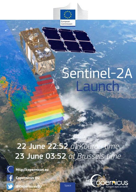
22 June 22:52 at Kourou time<br />
23 June 03:52 at Brussels time<br />
http://copernicus.eu<br />
Copernicus EU<br />
@CopernicusEU<br />
Space
© ESA-ATG medialab<br />
<strong>Sentinel</strong>-2<br />
What is <strong>Sentinel</strong>-<strong>2A</strong>?<br />
<strong>Sentinel</strong>-<strong>2A</strong> was launched from Europe’s Spaceport in With a 290 km-wide field of view, <strong>Sentinel</strong> <strong>2A</strong> will deliver<br />
Kourou (French Guiana) on 22 June (local time) on top images of Earth’s changing land with an unprecedented<br />
of a Vega launcher, making it the second satellite in frequency and level of detail and accuracy. <strong>Sentinel</strong> 2B<br />
orbit for Europe’s Copernicus programme. <strong>Sentinel</strong>-<strong>2A</strong> which will complete the constellation is expected for<br />
is a polar-orbiting, multispectral high-resolution launch mid-2016.<br />
imaging mission for land monitoring to provide, for<br />
example, imagery of vegetation, soil and water cover,<br />
<strong>Sentinel</strong>-2 mission<br />
inland waterways and coastal areas.<br />
With its systematic and frequent coverage, <strong>Sentinel</strong> 2<br />
will make a significant contribution to Land Monitoring<br />
<strong>Sentinel</strong> <strong>2A</strong> is a key element of the Copernicus Services by providing input data for land cover change<br />
programme of the European Union and features a mapping, as well as supporting the assessment of biogeophysical<br />
parameters of vegetation like Leaf Area<br />
two-satellite land monitoring constellation designed<br />
by the European Space Agency (ESA) and built by Index (LAI), Leaf Chlorophyll Content (LCC) and Leaf<br />
Airbus Defence and Space. The satellites’ development Cover (LC).<br />
capitalises on the know-how and advanced space <strong>Sentinel</strong> 2’s instruments comprise 13 spectral channels<br />
technologies from sixty European industrial partners. with a 290 km swath and spatial resolutions of 10 m<br />
Cooperation agreements between ESA and national (4 visible and near infrared bands), 20 m (6 red-edge/<br />
space agencies have been established in the area of shortwave infrared bands) and 60 m (3 atmospheric<br />
image quality (with the French CNES), inter-orbit optical correction bands). It is able to support a wide range of<br />
communications (with the German DLR), and for crosscalibrations<br />
(with NASA in the<br />
land studies and geophysical applications, reducing the<br />
U.S.).<br />
Space<br />
time required to build a rich and worldwide cloud-free<br />
imaging archive. The spectral bands of <strong>Sentinel</strong> 2 will<br />
Forest monitoring: contribution to the conservation of<br />
biodiversity in forests, soil conservation;<br />
provide data for land cover and change classification,<br />
atmospheric correction and separation between cloud and<br />
snow.<br />
Urban planning: supporting<br />
urban planning in order to<br />
ensure sustainable and balanced<br />
Operational information from this latest Copernicus development, providing the<br />
mission will help improve agricultural practices, monitor<br />
desertification and the state of the world’s forests, detect<br />
pollution in lakes and coastal waters, contribute to disaster<br />
mapping and much more.<br />
These high-level objectives specified in 2007, after intense<br />
consultation with user communities, will make <strong>Sentinel</strong> 2<br />
means for a consistent basis<br />
of comparison across Europe,<br />
allowing the tracking of urban<br />
developments to understand how<br />
policies trigger or suppress urban<br />
expansion;<br />
a significant asset for Copernicus Services such as Land<br />
Monitoring, Emergency Management, Security and Climate<br />
Change.<br />
Water monitoring: water stress assessment and water<br />
scarcity forecasting, as information on the extent and<br />
impact of water scarcity and drought is indispensable for<br />
The <strong>Sentinel</strong> 2 mission will support broader policy decision-making at national and continental scale;<br />
objectives of the European Union, particularly in the areas<br />
of climate and environment.<br />
Cryosphere: assisting in improving the understanding of<br />
the water cycle and climate, supporting decision-making at<br />
the public and private levels, supporting flood forecasting<br />
and early warning systems;<br />
© ESA-ATG medialab<br />
Concrete applications<br />
Agricultural monitoring: food security monitoring,<br />
agricultural production estimation, crop area monitoring<br />
for agricultural statistics;<br />
Disaster monitoring: responses to major disasters in<br />
the shortest possible time, assisting in the identification<br />
of priority areas for humanitarian and financial aid,<br />
providing essential geographical information for remote<br />
areas where the information is absent or inaccurate (e.g.<br />
following flooding or earthquakes);<br />
Soil conservation: supporting European decision-making<br />
and spatial planning authorities with consistent and<br />
comparable EU-wide information products to analyse<br />
current and potential future trends and impacts of land<br />
use changes for urban developments and infrastructure<br />
investment, the prevention of land degradation;<br />
Biodiversity monitoring: supporting European, national<br />
and local authorities in monitoring the state of European<br />
habitats, supporting research monitoring and the<br />
assessment of biodiversity.<br />
For more information, visit http://www.copernicus.eu/main/last-steps-road-launch
Copernicus is the EU Earth Observation and Monitoring Programme<br />
What is Copernicus?<br />
be served by a set of dedicated satellites (the <strong>Sentinel</strong>s)<br />
Copernicus is a European Union Programme aimed at and contributing missions (existing commercial and<br />
developing European information services based on public satellites). The <strong>Sentinel</strong>s are specifically designed<br />
satellite Earth Observation and in-situ (non-space) data to meet the needs of the Copernicus services and their<br />
analyses. The Programme is coordinated and managed users. Since the launch of <strong>Sentinel</strong>-1A in 2014, the<br />
by the European Commission. It is implemented in Union set in motion a process to place a constellation<br />
partnership with the Member States, the European of more than a dozen satellites in orbit over the course<br />
Space Agency (ESA), the European Organisation for the of the next ten years. <strong>Sentinel</strong>-1A provides a unique<br />
Exploitation of Meteorological Satellites (EUMETSAT), set of observations, starting with high-resolution, allweather,<br />
day and night radar images to be used for<br />
the European Centre for medium-range Weather<br />
Forecasts (ECMWF), EU Agencies and Mercator Océan. land and ocean services.<br />
Vast amounts of global data from satellites and from Copernicus collects information from In-situ systems<br />
ground-based, airborne and seaborne measurement such as ground stations, which deliver data acquired by<br />
systems are being used to provide information to a multitude of sensors on the ground, at sea or in the<br />
help service providers, public authorities and other air. These data come from European and non-European<br />
international organisations improve the quality of life organisations and from Member States as well.<br />
for the citizens of Europe. The information services Copernicus monitors: It stores the information and<br />
provided will be freely and openly accessible to its keeps track of changes or recurring phenomena: this<br />
users.<br />
constitutes a large amount of reliable and up-to-date<br />
How does Copernicus collect data? information on the status of our planet.<br />
The Copernicus Space and Service Components have Copernicus analyses: The data is analysed in a way<br />
been specifically designed to meet user requirements. that generates indicators useful for researchers and<br />
Through satellite and in-situ observations, the end users, providing information on past, present and<br />
services deliver near-real-time data on a global future trends. They can analyse, for example, the air<br />
level which can also be used for local and regional quality in our cities and detect visible and noticeable<br />
needs, to help us better understand our planet and<br />
sustainably manage the environment we live in.<br />
Copernicus observes from Satellites: Copernicus will<br />
Space<br />
increases in air pollution (smoke, dust, smog) • High resolution images, and lower<br />
or analyse the rise in global sea levels. resolution overviews;<br />
• Regular and systematic review of data;<br />
What are the services? • Reduced reaction time to enable better<br />
The services address six thematic areas: response to man-made or natural disasters;<br />
An Atmosphere Monitoring Service • Global/Pan European Approach to Earth<br />
⇢ fully operational from July 2015; monitoring.<br />
A Marine Environment Monitoring Service The Copernicus data policy promotes the<br />
⇢ fully operational since May 2015; access, use and sharing of Copernicus<br />
A Land Monitoring Service<br />
information and data on a full, free and<br />
⇢ fully operational since January 2013; open basis.<br />
A Climate Change Service<br />
How does Copernicus help<br />
⇢ in ramp-up phase;<br />
the citizens of Europe?<br />
An Emergency Management Service Copernicus is the concrete realisation of<br />
⇢ fully operational since April 2012; the European idea of providing our citizens<br />
A Security Service<br />
with new public services on both a European<br />
⇢ in ramp-up phase.<br />
and global scale. By investing in Earth<br />
monitoring and observation systems and<br />
What happens to the data? networks, which monitor and forecast the<br />
The Copernicus system delivers data and state of the environment on land, sea and<br />
information to Copernicus users, supplied in the atmosphere, we are now better able<br />
on a long term and sustainable basis understand our planet, protect and sustain<br />
through a set of services. The EC funds our environment and feel more safe and<br />
companies and public entities which provide secure.<br />
these services. The information can be used Copernicus in Action (examples)<br />
by end users for a wide range of applications • The Marine Environment Monitoring Service<br />
in a variety of areas. These include urban provided data to the Italian authorities<br />
area management, sustainable development supporting oil spill scenario calculations<br />
and nature protection, regional and local during the parbuckling of Costa Concordia;<br />
planning, agriculture, forestry and fisheries, • During the terrible floods that hit central<br />
health, civil protection, infrastructure, Europe in 2013 the Emergency Management<br />
transport and mobility, as well as tourism. Service provided reference maps and flood<br />
delineation to the affected areas;<br />
What is the added-value • Copernicus also plays an important role<br />
of the Copernicus System? in creating business opportunities for small<br />
• Guarantee of service, providing global and medium-sized enterprises, which create<br />
spatial coverage;<br />
jobs and growth. It is estimated that the<br />
• Near-real time data provided to end users; programme could result in some 48,000<br />
• Enable integration of the data (space and direct and indirect jobs being created over<br />
in-situ) and analyses;<br />
the period 2015-2030.<br />
Web: http://copernicus.eu | Facebook: Copernicus EU | Twitter: @CopernicusEU<br />
Photo credits: <strong>Sentinel</strong> ©ESA/DLR; Land Istock ©Dariusz Paciorek; Marine ©IStockphoto.com/Mercator-Ocean; Atmosphere ©FDC; Emergency: Fire Istock ©negaprion; Eartquake Fotolia ©puckillustrations; Flood ©On-Air; Security ©French Navy; Climate change Fotolia ©z576; In-situ component ©IRD, 2011.
0 5 10 20 Km<br />
Continuous Urban fabric (S.L. > 80%)<br />
Discontinuous Dense Urban Fabric (S.L.: 50% - 80%)<br />
Discontinuous Medium Density Urban Fabric (S.L.: 30% - 50%)<br />
Discontinuous Low Density Urban Fabric (S.L.: 10% - 30%)<br />
Discontinuous Very Low Density Urban Fabric (S.L. < 10%)<br />
Isolated Structures<br />
Industrial, commercial, public, military and private units<br />
Fast transit roads and associated land<br />
Other roads and associated land<br />
Railways and associated land<br />
Port areas<br />
Airports<br />
Mineral extraction and dump sites<br />
Construction sites<br />
Land without current use<br />
Green urban areas<br />
Sports and leisure facilities<br />
Agricultural Areas, semi-natural areas and wetlands<br />
Forests<br />
Water<br />
No data<br />
0 0.75 1.5 Km<br />
Observing our planet for a safer world<br />
The Local component of the Copernicus<br />
a comparison can be made between the<br />
Land Monitoring Service<br />
Land Monitoring Service is also managed by<br />
the EEA. It aims to provide specific and more<br />
situation before and after the crisis to<br />
understand if and how this can be prevented<br />
The Copernicus Land Monitoring Service is part of the Copernicus Programme, which is an EU<br />
Programme managed by the European Commission (EC) and implemented in partnership with the<br />
Member States, the European Space Agency (ESA), the European Organisation for the Exploitation<br />
of Meteorological Satellites (EUMETSAT), the European Centre for medium-range Weather Forecasts<br />
(ECMWF), EU Agencies and Mercator Océan. The Programme is aimed at developing a set of European<br />
detailed information complementing the<br />
information produced by the Pan-European<br />
component. It focuses on “hotspots”<br />
which are prone to specific environmental<br />
challenges in Europe.<br />
by smart urban planning.<br />
Bruxelles / Brussel<br />
High Resolution Layer<br />
Forest Tree cover density<br />
(Brno, CZ)<br />
information services based on satellite Earth Observation and in-situ (non-space) data analyses.<br />
What is the Copernicus<br />
Land Monitoring Service?<br />
The Copernicus Land Monitoring Service provides<br />
the energy budget (e.g. land surface temperature) and<br />
the water cycle (e.g. soil water index, water bodies)<br />
every ten days and on a worldwide scale.<br />
geographical information on land cover, land use, The biophysical parameters production is<br />
land cover-use changes over the years, vegetation<br />
state or water cycle. Applications that are built upon<br />
and integrate the information supplied by the service<br />
can provide support in areas such as spatial planning,<br />
complemented with an activity providing detailed<br />
and high resolution land cover - land use information<br />
on specific hot spot areas around the world, mainly<br />
targeted to support biodiversity preservation.<br />
forest management, water management, agriculture<br />
and food security and emergency management,<br />
amongst others.<br />
Service priorities and their relevance to users are<br />
defined and validated by the EC and the Member<br />
States.<br />
The service became operational in 2012.<br />
The Pan-European component is managed by the<br />
What does the Land Monitoring Service do?<br />
The three main components of the Copernicus Land<br />
Monitoring Service are currently:<br />
A Global component;<br />
A Pan-European component;<br />
EEA and is producing high resolution information<br />
sets describing the main land cover types: artificial<br />
surfaces (e.g. roads and paved areas), forest areas,<br />
agricultural areas (grasslands), wetlands and small<br />
water bodies.<br />
A Local component.<br />
The Global component of the Copernicus Land<br />
Monitoring Service is managed by the European<br />
Commission’s Directorate Joint Research Centre. It<br />
produces biophysical parameters that give a picture<br />
of the state of vegetation (e.g. leaf area index, fraction<br />
of green vegetation cover, vegetation condition index),<br />
Space<br />
The Urban Atlas, one of the local components,<br />
focuses on the mapping and change analysis<br />
of urban areas. It provides reliable, intercountry<br />
comparable, high resolution land<br />
use maps for 695 European cities and their<br />
surroundings for the reference years 2006<br />
and 2012 which allow land use comparisons<br />
across cities and over time.<br />
The Urban Atlas is used to detect building<br />
footprints, land use changes, urban sprawl<br />
and urban green area decline and high urban<br />
densities. The information is used to prioritise<br />
public transport, support emergency planning<br />
or promote sustainable urban development<br />
in general in a pan-European comparable<br />
mode.<br />
For example, in the case of mapping<br />
areas affected by emergency situations,<br />
Larger Urban Zone: Bruxelles / Brussel<br />
REGIOgis<br />
Urban Atlas map: Brussels<br />
Who can use it and is it for free?<br />
The Copernicus data policy promotes the<br />
access, use and sharing of Copernicus<br />
information and data on a full, free and<br />
open basis. There is no restriction on use<br />
or reproduction and redistribution, with or<br />
without adaptation, for commercial or noncommercial<br />
purposes.<br />
This data policy applies to the data and<br />
information generated within the Copernicus<br />
programme, i.e., <strong>Sentinel</strong> mission data and<br />
Copernicus service information.<br />
Users can find out more about the Copernicus Land Monitoring Service at: http://land.copernicus.eu/<br />
Corine Land cover<br />
(minimum mapping unit 25 ha)<br />
Corine Land Cover: the distribution<br />
of aggregated land cover classes<br />
Global Land biophysical<br />
parameters: Albedo<br />
Photo credits: Land iStock©Dariusz Paciorek; Deforestation Fotalia ©guentermanaus; Demographic expansion iStock ©Ammit; All the maps are provided by ©EC.
Marine environment issues<br />
What is the added value of the<br />
Marine Environment Monitoring Service<br />
The Copernicus Marine Environment<br />
Monitoring Service assimilates marine data<br />
into 3D models and then reanalyses these<br />
Copernicus Marine Environment<br />
Monitoring Service?<br />
• The Service provides a single point of<br />
The Copernicus Marine Environment Monitoring Service is part of the Copernicus Programme, which<br />
is an EU Programme managed by the European Commission (EC) and implemented in partnership with<br />
the Member States, the European Space Agency (ESA), the European Organisation for the Exploitation<br />
of Meteorological Satellites (EUMETSAT), the European Centre for medium-range Weather Forecasts<br />
(ECMWF), EU Agencies and Mercator Océan. The Programme is aimed at developing a set of European<br />
information services based on satellite Earth Observation and in-situ (non-space) data analyses.<br />
What is the Copernicus<br />
What does the Copernicus<br />
Marine Environment Monitoring Service? Marine Environment Monitoring Service do?<br />
The Copernicus Marine Environment Monitoring The service provides information on the ocean for the<br />
Service provides regular and systematic information large scale (worldwide coverage) and regional scales<br />
about the physical state and dynamics of the ocean (main European basins and seas).<br />
and marine ecosystems for the global ocean and the Typical products provided by the service are:<br />
European regional seas. This data covers analysis of • Maps and data for oceanographic forecasts;<br />
the current situation, forecasts of the situation a few • Retrospective assessments of the sea state;<br />
days in advance and the provision of retrospective • Simulations of pollution transport;<br />
data records (re-analysis).<br />
• Inputs to fine scale analysis in coastal areas.<br />
The Copernicus Marine Environment Monitoring Service<br />
calculates and provides products describing currents,<br />
temperature, wind, salinity, sea level, sea ice and<br />
biogeochemistry. These factors support marine and<br />
maritime applications and related EU policies, e.g. in<br />
the fields of:<br />
Marine safety;<br />
Some examples:<br />
Marine and coastal environment;<br />
Shipping and sea rescue services<br />
Marine resources;<br />
The Copernicus Marine Environment Monitoring Service<br />
Weather, seasonal forecasting and climate.<br />
collects observational data about the sea level, sea<br />
surface temperature, sea ice and sea surface wind<br />
In November 2014, the European Commission signed<br />
using in-situ sensors and earth observation satellites<br />
a Delegation Agreement with Mercator Océan for the<br />
which can provide useful information for ship routing<br />
implementation of the service. The service became<br />
services or search and rescue operations.<br />
fully operational in April 2015.<br />
over long term periods in the past. This<br />
work helps address marine and coastal<br />
environment issues.<br />
Products delivered by the Copernicus Marine<br />
Environment Monitoring Service contribute to<br />
the protection and sustainable management<br />
of living marine resources, including fish<br />
stock management.<br />
Understanding weather<br />
and climate change<br />
Many of the data delivered by the service<br />
(e.g. temperature, currents) play a crucial<br />
role in the domain of weather, climate<br />
and seasonal forecasting. The Service also<br />
records the status of polar icecaps, which<br />
helps us to understand the impact of climate<br />
change.<br />
access to a large variety of marine data and<br />
information;<br />
• The critical data produced by the Copernicus<br />
Marine Environment Monitoring Service helps<br />
scientists better understand the ocean and<br />
EU regional seas;<br />
• Monitoring of sea ice together with its<br />
forecast can provide useful information to<br />
marine transport in ice infested waters;<br />
• The service provides useful information for<br />
various activities in the context of fisheries<br />
and mariculture, tourism, or the overall<br />
management of coastal zones;<br />
• Freely available high quality data opens<br />
new possibilities in monitoring our marine<br />
environment and enables new business<br />
ideas in a wide area of marine activities.<br />
The Copernicus data policy promotes the<br />
access, use and sharing of Copernicus<br />
information and data on a full, free and<br />
open basis.<br />
The Costa Concordia: Fuel leak simulation illustrated by<br />
surface oil concentration (tonne/km²)<br />
on March 31st 2011.<br />
A Japanese use case<br />
(Fukushima):<br />
Search and Rescue Scenario<br />
Salinity:<br />
Information relevant<br />
for water quality monitoring<br />
and pollution control<br />
Search and rescue scenario<br />
Sea Surface Temperature<br />
on a global scale<br />
Photo credits: Ocean ©IStockphoto.com/Mercator-Ocean; Boat Istock ©vice_and_virtue; Fishes ©iStockphoto.com-MyOcean; Costa Concordia by courtesy of INGV ©; A japanese use case (Fukushima) ©MyOcean-Mercator Ocean; Salinity ©MyOcean-Mercator Ocean; Search and Rescue Scenario Screenshot by courtesy of Salvamento Marítimo ©; Sea Surface temperature ©MyOcean-Mercator Ocean.<br />
Space<br />
Users can find out more about the products delivered by the Copernicus Marine Environment Monitoring Service at: http://marine.copernicus.eu<br />
The products delivered by the Copernicus Marine Environment Monitoring Service are provided free of charge to registered users through a Catalogue available at: http://operation.myocean.eu/web/24-catalogue.php
Atmosphere Monitoring Service<br />
The Copernicus Atmosphere Monitoring Service is part of the Copernicus Programme, which is an<br />
EU Programme managed by the European Commission (EC) and implemented in partnership with the<br />
Member States, the European Space Agency (ESA), the European Organisation for the Exploitation<br />
of Meteorological Satellites (EUMETSAT), the European Centre for medium-range Weather Forecasts<br />
(ECMWF), EU Agencies and Mercator Océan. The Programme is aimed at developing a set of European<br />
information services based on satellite Earth Observation and in-situ (non-space) data analyses.<br />
What is the Copernicus<br />
Atmosphere Monitoring Service?<br />
The Copernicus Atmosphere Monitoring Service<br />
provides the capacity to continuously monitor the<br />
composition of the Earth’s atmosphere at global and<br />
regional scales. This service capacity encompasses<br />
the description of the current situation (analysis), the<br />
prediction of the situation a few days ahead (forecast),<br />
and the provision of consistent retrospective data<br />
records for recent years (re-analysis). The service<br />
generates geophysical products which require further<br />
technical processing and various forms of high level<br />
information to support decision makers.<br />
The main areas that the Copernicus Atmosphere<br />
Monitoring Service focuses on are:<br />
Air quality and atmospheric composition;<br />
Ozone layer and ultra-violet radiation;<br />
Emissions and surface fluxes;<br />
Solar radiation;<br />
Climate forcing.<br />
Space<br />
In November 2014, the European Commission<br />
signed a Delegation Agreement with ECMWF for the<br />
implementation of the service. The service will be fully<br />
operational from July 2015.<br />
Pollution forecast for Brussels<br />
What does<br />
the Atmosphere Monitoring Service do?<br />
Typical products provided by the service are:<br />
• Maps and data for regional air quality forecasts;<br />
• Retrospective assessments of air quality;<br />
• Identification of pollutants and their source;<br />
• Pollen concentration levels in the atmosphere;<br />
• Resources for evaluating possible emission control<br />
measures;<br />
• Inputs to local air quality forecasts, health information<br />
and warnings.<br />
Some examples:<br />
Air Quality<br />
The Copernicus Atmosphere Monitoring<br />
Service provides continuous observation of<br />
the composition of the Earth’s atmosphere<br />
and helps predict air quality. Atmospheric<br />
composition helps to understand phenomena<br />
such as desert dust plumes, long-range<br />
transport of atmospheric pollutants including<br />
pollen as well as ash plumes from volcanic<br />
eruptions. This information can be relevant<br />
for different domains such as public health<br />
or even safety of air traffic.<br />
Each day, the Copernicus Atmosphere<br />
Monitoring Service provides analyses and<br />
forecasts detailing constituents in the Earth’s<br />
atmosphere at various heights above sea<br />
level for the next 96 hours.<br />
Solar Radiation<br />
The Service also monitors levels of UV<br />
radiation and provides 4-day forecasts<br />
on a European and global scale, which<br />
helps optimise the use of solar energy and<br />
supports the prevention of skin cancer.<br />
What is the added value of<br />
the Copernicus<br />
Atmosphere Monitoring Service?<br />
• The service delivers information on the air<br />
we breathe;<br />
• The recording and analysis of solar<br />
radiation provides information to public and<br />
private organisations in fields such as health,<br />
agriculture and solar energy;<br />
• The service compiles emission data and<br />
also estimates net fluxes of CO 2<br />
and CH 4<br />
at the Earth’s surface. This helps improve<br />
understanding of key climate forcings;<br />
• Freely available high quality data opens new<br />
possibilities in monitoring the composition<br />
of the atmosphere and enables the creation<br />
of new business ideas supporting public<br />
and private stakeholders in a wide area of<br />
applications linked to atmospheric science.<br />
The Copernicus data policy promotes the<br />
access, use and sharing of Copernicus<br />
information and data on a full, free and<br />
open basis.<br />
Surface Carbon Monoxide<br />
Total Aerosol Optical Depth<br />
Surface parameter:<br />
Nitrogen dioxide<br />
Average of Observed<br />
Fire Radiative<br />
Power Areal Density<br />
Co 2 concentration over Africa<br />
Global nitrogen oxides<br />
Users can find out more about the products delivered by the Copernicus Atmosphere Monitoring Service at: http://atmosphere.copernicus.eu<br />
Photo credits: Atmosphere ©FDC; Smokestacks Istock ©Mykhailo Shcherbyna; All the maps are provided by the maps are provided by ©the EU-funded FP7 project MACC-II.
Terkelsbol<br />
4977000<br />
44°55'0"N<br />
4974000<br />
44°54'0"N<br />
4971000<br />
44°53'0"N<br />
44°52'0"N<br />
4968000<br />
44°51'0"N<br />
4965000<br />
4962000<br />
5717000<br />
5716000<br />
44°50'0"N<br />
44°49'0"N<br />
44°48'0"N<br />
44°47'0"N<br />
51°35'0"N<br />
5715000<br />
51°34'0"N<br />
5714000<br />
5713000<br />
51°33'0"N<br />
5712000<br />
5711000<br />
51°32'0"N<br />
54°57'0"N<br />
54°56'0"N<br />
54°55'0"N<br />
3578000<br />
11°0'0"E<br />
12°57'0"E<br />
358000<br />
3577500<br />
32°18'20"N<br />
3577000<br />
3576500<br />
3576000<br />
3575500<br />
32°18'0"N<br />
32°17'40"N<br />
32°17'20"N<br />
3575000<br />
32°17'0"N<br />
6090000<br />
6089000<br />
6088000<br />
6087000<br />
6086000<br />
6085000<br />
11°0'0"E<br />
11°1'0"E<br />
Kirche<br />
Zinna<br />
^<br />
V<br />
4<br />
" 4<br />
;Ø<br />
""<br />
" "<br />
"<br />
"<br />
"<br />
"<br />
"<br />
"<br />
"<br />
"<br />
"<br />
"<br />
""<br />
"<br />
" " "<br />
"<br />
" " "<br />
"<br />
"<br />
"<br />
"<br />
"<br />
"<br />
" "<br />
"<br />
"<br />
"<br />
"<br />
"<br />
"<br />
"<br />
"<br />
"<br />
F<br />
"<br />
"<br />
"<br />
"<br />
"<br />
"<br />
"<br />
" "<br />
"<br />
"<br />
" " "<br />
9 Carabinieri "<br />
"<br />
"<br />
"<br />
;Ø<br />
"<br />
""<br />
" "<br />
"<br />
"<br />
4<br />
;Ø<br />
"<br />
""<br />
"<br />
"<br />
Ospedale Santa<br />
"<br />
4<br />
"<br />
"<br />
Maria Bianca<br />
4 " "<br />
"<br />
"<br />
"<br />
"<br />
Mirandola<br />
"<br />
4 4<br />
"<br />
" " "<br />
" "<br />
"" "<br />
" "<br />
"<br />
4<br />
"<br />
"<br />
" "<br />
"<br />
Detailed Area<br />
"<br />
" ""<br />
"<br />
" of Interest 1<br />
" "<br />
"<br />
"<br />
"<br />
"<br />
"<br />
"<br />
"<br />
"<br />
" " "<br />
"<br />
" "<br />
" "<br />
"<br />
" "<br />
"<br />
"<br />
"<br />
"<br />
"<br />
" " "<br />
" " ""<br />
"<br />
"<br />
"<br />
"<br />
" ;Ø<br />
" "<br />
" "<br />
" " " "<br />
"<br />
"<br />
;Ø<br />
""<br />
"<br />
"<br />
"<br />
;Ø<br />
" " "<br />
"<br />
""<br />
"<br />
"<br />
"<br />
" "<br />
" "<br />
"<br />
"<br />
"<br />
"<br />
"<br />
"<br />
"<br />
"<br />
"<br />
Medolla<br />
""<br />
"<br />
"<br />
"<br />
"<br />
" ""<br />
"<br />
" "<br />
"<br />
"<br />
"<br />
"<br />
" "<br />
"<br />
"<br />
"<br />
"<br />
Comune di<br />
"<br />
"<br />
""<br />
"<br />
"<br />
modolla<br />
" ;Ø<br />
"<br />
"<br />
"<br />
" 9<br />
"<br />
"<br />
"<br />
"<br />
"<br />
Polizia<br />
"<br />
""<br />
Municipale<br />
" " "<br />
" " San Felice<br />
" " " "<br />
F<br />
"<br />
Municipio<br />
"<br />
"<br />
" "<br />
" "<br />
"<br />
9<br />
"<br />
"<br />
""<br />
"<br />
"<br />
"<br />
"<br />
"<br />
" "<br />
""<br />
" "<br />
"<br />
9<br />
""<br />
4<br />
" "<br />
" "<br />
"<br />
"<br />
"<br />
"<br />
"<br />
""<br />
"<br />
"""<br />
" "" "<br />
"<br />
"<br />
""<br />
"<br />
"<br />
"<br />
"" "<br />
"<br />
"<br />
"<br />
""<br />
" "<br />
"<br />
"<br />
""<br />
"<br />
"<br />
Cavezzo "<br />
"<br />
Detailed Area<br />
""<br />
of Interest 2<br />
"<br />
"""<br />
"<br />
"<br />
" "<br />
"<br />
"<br />
"<br />
"<br />
"<br />
"<br />
"<br />
"<br />
"<br />
"<br />
""<br />
"<br />
"<br />
"<br />
"<br />
" "<br />
"<br />
"<br />
"<br />
;Ø<br />
ia Sa bioni<br />
"<br />
""<br />
11°1'0"E<br />
660000<br />
660000<br />
11°2'0"E<br />
11°2'0"E<br />
Via Statale<br />
358000<br />
359000<br />
12°57'0"E<br />
12°58'0"E<br />
Area of Interest - Detail<br />
246000<br />
246000<br />
9°12'0"E<br />
513000<br />
Kravlund<br />
513000<br />
9°12'0"E<br />
36°18'20"E<br />
36°18'20"E<br />
12°58'0"E<br />
359000<br />
Welsau<br />
!<br />
Zi naer Straße<br />
246500<br />
Area of Interest<br />
Detail - Za'atri<br />
246500<br />
36°18'40"E<br />
9°13'0"E<br />
514000<br />
514000<br />
9°13'0"E<br />
11°3'0"E<br />
Kirche zu<br />
Welsau<br />
^<br />
Via Bosco<br />
663000<br />
11°4'0"E<br />
S12<br />
Via Gregorio<br />
Agnini<br />
Via Sa<br />
Via de l'Industria<br />
bioni<br />
11°3'0"E<br />
11°4'0"E<br />
663000<br />
Via de le<br />
te<br />
11°5'0"E<br />
Viale Antonio Gramsci<br />
11°5'0"E<br />
666000<br />
11°6'0"E<br />
11°6'0"E<br />
666000<br />
Via Ma zone<br />
Via Casarino<br />
11°7'0"E<br />
ViaProvinciale<br />
Torgau<br />
X<br />
Tagesklinik Torgau<br />
Kreis-Krankenhaus<br />
K<br />
K Torgau<br />
Kreisvolkshochschule<br />
^ Neuapostolische Torgau Berufsschule<br />
!<br />
Kirche<br />
^<br />
Katholische<br />
Stadtkirche<br />
Kirche Torgau<br />
St. Marien<br />
^<br />
Großer<br />
Teich<br />
360000<br />
12°59'0"E<br />
12°59'0"E<br />
360000<br />
247000<br />
36°18'40"E<br />
247000<br />
36°19'0"E<br />
361000<br />
13°0'0"E<br />
Alte<br />
Elbe<br />
Kuhteich<br />
Gehegeteich<br />
13°0'0"E<br />
361000<br />
4<br />
247500<br />
36°19'0"E<br />
9°14'0"E<br />
515000<br />
><br />
515000<br />
9°14'0"E<br />
247500<br />
Hafen<br />
Torgau<br />
36°19'20"E<br />
Tinglev<br />
Via Galea za<br />
11°7'0"E<br />
362000<br />
362000<br />
248000<br />
36°19'20"E<br />
via Pero sara<br />
Repitz !<br />
248000<br />
9°15'0"E<br />
516000<br />
516000<br />
9°15'0"E<br />
669000<br />
11°8'0"E<br />
11°9'0"E<br />
Via Va li<br />
13°1'0"E<br />
11°8'0"E<br />
669000<br />
13°1'0"E<br />
Alte<br />
Elbe<br />
Losswig<br />
!<br />
Via de la<br />
Repu blica<br />
363000<br />
11°9'0"E<br />
Bruckenkopf<br />
!<br />
Elbe<br />
363000<br />
248500<br />
36°19'40"E<br />
36°19'40"E<br />
248500<br />
"<br />
"<br />
"<br />
"<br />
"<br />
"<br />
"<br />
"<br />
"<br />
"<br />
"<br />
"<br />
"<br />
"<br />
"<br />
"<br />
"<br />
"<br />
"<br />
"<br />
"<br />
"<br />
"<br />
"<br />
"<br />
"<br />
"<br />
"<br />
"<br />
"<br />
"<br />
"<br />
"<br />
"<br />
"<br />
"<br />
"<br />
"<br />
"<br />
"<br />
"<br />
"<br />
"<br />
"<br />
"<br />
"<br />
"<br />
"<br />
"<br />
"<br />
"<br />
"<br />
"<br />
"<br />
"<br />
"<br />
"<br />
"<br />
"<br />
"<br />
"<br />
"<br />
"<br />
"<br />
"<br />
"<br />
"<br />
"<br />
"<br />
11°10'0"E<br />
" " "<br />
"<br />
"<br />
"<br />
"<br />
"<br />
"<br />
"<br />
F<br />
Kirche<br />
Kreichau<br />
^!<br />
Kreischau<br />
"<br />
"<br />
"<br />
"<br />
"<br />
"<br />
"<br />
"<br />
"<br />
"<br />
"<br />
"<br />
"<br />
"<br />
"<br />
"<br />
"<br />
"<br />
"<br />
"<br />
"<br />
"<br />
"<br />
"<br />
"<br />
"<br />
"<br />
"<br />
"<br />
"<br />
"<br />
"<br />
"<br />
"<br />
"<br />
"<br />
"<br />
"<br />
! Werdau<br />
alte<br />
Elbe<br />
"<br />
"<br />
"<br />
"<br />
"<br />
"<br />
"<br />
"<br />
"<br />
"<br />
"<br />
"<br />
"<br />
"<br />
"<br />
""<br />
"<br />
"<br />
"<br />
"<br />
"<br />
"<br />
"<br />
"<br />
"<br />
"<br />
"<br />
"<br />
"<br />
"<br />
"<br />
"<br />
"<br />
"<br />
"<br />
"<br />
"<br />
"<br />
"<br />
"<br />
"<br />
"<br />
"<br />
"<br />
"<br />
"<br />
"<br />
"<br />
"<br />
"<br />
"<br />
"<br />
"<br />
"<br />
"<br />
"<br />
"<br />
"<br />
"<br />
"<br />
"<br />
"<br />
"<br />
"<br />
"<br />
"<br />
"<br />
"<br />
"<br />
"<br />
"<br />
"<br />
"<br />
"<br />
"<br />
"<br />
"<br />
"<br />
""<br />
"<br />
"<br />
"<br />
"<br />
"<br />
"<br />
"<br />
"<br />
"<br />
"<br />
"<br />
"<br />
"<br />
"<br />
"<br />
"<br />
""<br />
"<br />
"<br />
"<br />
"<br />
"<br />
"<br />
"<br />
"<br />
"<br />
"<br />
"<br />
"<br />
"<br />
"<br />
"<br />
"<br />
"<br />
9°16'0"E<br />
517000<br />
"<br />
"<br />
"<br />
"<br />
"<br />
"<br />
"<br />
"<br />
"<br />
"<br />
"<br />
"<br />
"<br />
"<br />
"<br />
"<br />
"<br />
"<br />
"<br />
"<br />
"<br />
"<br />
"<br />
"<br />
"<br />
"<br />
"<br />
"<br />
"<br />
"<br />
"<br />
"<br />
"<br />
"<br />
"<br />
"<br />
"<br />
"<br />
"<br />
"<br />
"<br />
"<br />
"<br />
"<br />
"<br />
"<br />
"<br />
"<br />
"<br />
"<br />
"<br />
"<br />
"<br />
"<br />
"<br />
"<br />
"<br />
"<br />
"<br />
"<br />
"<br />
"<br />
"<br />
"<br />
"<br />
"<br />
"<br />
"<br />
"<br />
"<br />
"<br />
"<br />
"<br />
"<br />
"<br />
"<br />
"<br />
517000<br />
9°16'0"E<br />
"<br />
"<br />
"<br />
"<br />
672000<br />
11°11'0"E<br />
"<br />
" " " "<br />
"<br />
"<br />
"<br />
"<br />
" "<br />
11°10'0"E<br />
11°11'0"E<br />
672000<br />
13°2'0"E<br />
"<br />
"<br />
364000<br />
13°2'0"E<br />
"<br />
11°12'0"E<br />
11°12'0"E<br />
! Zwethau<br />
^<br />
Kirche Zwethau<br />
364000<br />
Herzberger Straße<br />
Eulenau<br />
!<br />
249000<br />
36°20'0"E<br />
36°20'0"E<br />
249000<br />
9°17'0"E<br />
518000<br />
518000<br />
9°17'0"E<br />
365000<br />
13°3'0"E<br />
13°3'0"E<br />
365000<br />
675000<br />
11°13'0"E<br />
11°13'0"E<br />
675000<br />
11°14'0"E<br />
11°14'0"E<br />
Torgau-Beilrode<br />
Airfield<br />
X Beilrode X<br />
249500<br />
36°20'20"E<br />
36°20'20"E<br />
249500<br />
Graditz<br />
!<br />
Dorfstraße<br />
366000<br />
13°4'0"E<br />
r aße<br />
13°4'0"E<br />
366000<br />
9°18'0"E<br />
519000<br />
11°15'0"E<br />
GLIDE number: EQ-2012-000090-ITA<br />
Activation ID: EMSR004<br />
Product N.:05SanFelice, v2<br />
San Felice, Emilia Romagna, ITALY<br />
Earthquake - 29/05/2012<br />
Delineation Map - Overview<br />
Production date: 21/06/2012<br />
44°55'0"N<br />
44°54'0"N<br />
4974000<br />
44°53'0"N<br />
44°52'0"N<br />
4971000<br />
44°51'0"N<br />
44°50'0"N<br />
44°49'0"N<br />
4965000<br />
44°48'0"N<br />
44°47'0"N<br />
36°20'40"E<br />
250000<br />
519000<br />
9°18'0"E<br />
4977000<br />
4968000<br />
4962000<br />
51°35'0"N<br />
51°34'0"N<br />
51°33'0"N<br />
5717000<br />
5716000<br />
5715000<br />
5714000<br />
5713000<br />
5712000<br />
51°32'0"N<br />
5711000<br />
Cartographic Information<br />
1:30 000<br />
Full color ISO A1, high resolution (300 dpi)<br />
0 0,5 1 2<br />
km<br />
Map Coordinate System: WGS 1984 UTM Zone 32N<br />
Graticule: WGS 84 geographical coordinates<br />
Legend<br />
Areas of interest Transportation<br />
Crisis Information<br />
Primary Road<br />
;Ø Gathering of People<br />
Secondary Road<br />
" Affected Building<br />
Local Road<br />
Building Blocks<br />
Other<br />
Affected<br />
Railway<br />
Not Affected Points of Interest<br />
X Transportation K Medical<br />
9 Institutional F Cemetery<br />
4 Educational<br />
Map Information<br />
Data Sources<br />
Background imagery: WorldView-02 © Digitalglobe (0% cloudy, 0.5 m resolution, acquired on<br />
30/05/2012)<br />
LandScan ©UT BATTELLE, LLC. 2010 (approx. 1km resolution).<br />
Base vector layers based on Openstreetmap and Wikimapia refined by SIRS (nominal scale<br />
1:5000).<br />
All Data sources are complete and with no gaps.<br />
Dissemination/Publication<br />
No restrictions on the publication of the mapping apply.<br />
Delivery formats are GeoTIFF, GeoPDF, GeoJPEG and vectors (shapefile and KML formats).<br />
Framework<br />
The products elaborated for this rapid mapping has been realized to the best of our ability,<br />
within a very short time frame during a crisis, optimising the available data and information.<br />
All geographic information has limitations due to scale, resolution, date and interpretation of<br />
the original data sources. The products are compliant with GIO-EMS RUSH Product Portfolio<br />
specifications.<br />
Map production<br />
Civil Protection<br />
Response<br />
Delineation Map - Overview<br />
Planning<br />
WorldView-02 satellite imagery<br />
Earthquake<br />
29-05-2012<br />
GLIDE number: N/A<br />
Activation ID: EMSR-044<br />
Product N.: 04Torgau, v1<br />
Torgau - GERMANY<br />
Flood - 03/06/2013<br />
Delineation Map - Detail<br />
!.<br />
Production date: 05/06/2013<br />
Denmark<br />
BalticOder<br />
North<br />
Sea<br />
Sea<br />
Netherlands<br />
Berlin<br />
Brandenburg<br />
^ Poland<br />
Belgium Germany<br />
^<br />
Czech<br />
Republic<br />
France<br />
Sachsen-Anhalt<br />
Austria<br />
Switzerland<br />
!.<br />
Germany<br />
Torgau<br />
Sachsen<br />
!.<br />
Cartographic Information<br />
1:12500<br />
Full color ISO A1, high resolution (300 dpi)<br />
0 0,25 0,5 1<br />
km<br />
Map Coordinate System: WGS 1984 UTM Zone 33N<br />
Graticule: WGS 84 geographical coordinates<br />
Legend<br />
Crisis Information Hydrology Point of Interest<br />
Flood (04/06/2013) Canal 4 Educational<br />
General Information Stream K Medical<br />
Area of Interest<br />
Lake ^ Religious<br />
Settlements<br />
Reservoir X Transportation<br />
! Populated Place<br />
River Transportation<br />
Industrial<br />
!(u Helipad<br />
Multi-functional<br />
Railway<br />
Industry / Utilities<br />
Primary Road<br />
Power Substation<br />
Secondary Road<br />
Local Road<br />
Consequences within the Detail AOI on 04/06/2013<br />
Estimated Population<br />
0 inhabitants<br />
Transportation<br />
1.16 km<br />
Land use Forest 3.5 ha Grassland 2.30 ha<br />
Agricolture 246.82 ha Scrub 0 ha<br />
Map Information<br />
Data Sources<br />
Elbe<br />
Dissemination/Publication<br />
No restrictions on the publication of the mapping apply.<br />
Delivery formats are GeoTIFF, GeoPDF, GeoJPEG and vectors (shapefile and KML formats).<br />
Framework<br />
The products elaborated in the framework of current mapping in rush mode activation are realized<br />
to the best of our ability, within a very short time frame during a crisis, optimising the available data<br />
and information. All geographic information has limitations due to scale, resolution, date and<br />
interpretation of the original data sources. The products are compliant with GIO-EMS RUSH<br />
Product Portfolio specifications.<br />
Map Production<br />
Civil Protection<br />
Response<br />
Delineation Map - Detail<br />
Planning<br />
COSMO-SkyMed<br />
Flood<br />
03-06-2013<br />
250000<br />
36°20'40"E<br />
GLIDE number: OT-2012-000135-JOR<br />
Activation ID: EMSR-014<br />
Product N.: 00AlMafraq, v1<br />
Al Mafraq - JORDAN<br />
Refugee camp authorized area<br />
Reference Map - Detail Monit 08<br />
Production date: 28/11/2012<br />
32°18'40"N<br />
3578000<br />
32°18'20"N<br />
32°18'0"N<br />
32°17'40"N<br />
3577500<br />
3577000<br />
3576500<br />
3576000<br />
32°17'20"N<br />
3575500<br />
32°17'0"N<br />
3575000<br />
6090000<br />
6089000<br />
6088000<br />
6087000<br />
6086000<br />
6085000<br />
54°57'0"N<br />
54°56'0"N<br />
54°55'0"N<br />
Cartographic Information<br />
1:6,000<br />
Full color ISO A1, high resolution (300 dpi)<br />
0 125 250 500<br />
m<br />
Map Coordinate System: WGS 1984 UTM Zone 37N<br />
Graticule: WGS 84 geographical coordinates<br />
Legend<br />
General Information Building<br />
Area of Interest<br />
Other or Unknown<br />
Transportation<br />
Residential<br />
Primary Road Built-Up Area<br />
Local Road<br />
Refugee camp<br />
Other<br />
Residential<br />
Aerodrome<br />
Runway<br />
Number of shelters/tents: 7,708 units<br />
Number of people hosted in the refugee camp: more than 40,941 inhabitants<br />
(Source: UNHCR Syrian Regional Refugee Response weekly update, 28th November 2012,<br />
http://data.unhcr.org/syrianrefugees/country.php?id=107)<br />
Map Information<br />
Data Sources<br />
Dissemination/Publication<br />
Delivery formats are GeoTIFF, GeoPDF, GeoJPEG and vectors (shapefile and KML formats).<br />
Framework<br />
The products elaborated in the framework of current mapping in rush mode activation are<br />
realized to the best of our ability, within a very short time frame during a crisis, optimising the<br />
available data and information. All geographic information has limitations due to scale,<br />
resolution, date and interpretation of the original data sources. The products are compliant<br />
with GIO-EMS RUSH Product Portfolio specifications.<br />
Map production<br />
Humanitarian Aid<br />
Response<br />
Reference Map - Detail<br />
Planning<br />
WorldView-02 (c) DigitalGlobe<br />
Other<br />
27-07-2012<br />
GLIDE number: N/A<br />
Activation ID: EMSN-004<br />
Product N.: 02TRIPLEX, v01<br />
NORDLAND and SYDLAND<br />
Post Disaster Situation Map<br />
Detail<br />
Prodution Date: 03/09/2013<br />
France<br />
Spain<br />
Portugal<br />
NORDLAND<br />
ODENSE<br />
Morocco<br />
^<br />
NEKSDOHR<br />
ABENRA<br />
^<br />
^<br />
FLENSBURG<br />
SYDLAND<br />
0 50 100 150 200<br />
km<br />
Cartographic Information<br />
1:10,000<br />
Full color A1, low resolution (300dpi)<br />
Meters<br />
0 100 200 300 400 500<br />
Map Coordinate System: WGS 1984 UTM Zone 32N<br />
Graticule: WGS 84 Geographical Coordinates<br />
Legend<br />
Administrative<br />
Hydrology<br />
Water Course<br />
Country Border<br />
Simulated Inundation Extent<br />
Critical Crisis Infrastructure<br />
" IDP Tent<br />
IDP Camp > Evacuation Point<br />
Transportation<br />
Motorway<br />
Motorway, Flooded<br />
Primary Route<br />
Primary Route, Flooded<br />
Secondary & Local Route<br />
Secondary & Local Route, Flooded<br />
Railway<br />
Railway, Flooded<br />
Harbor<br />
Harbor, Affected<br />
o Airport<br />
o Airport, Flooded<br />
Population<br />
Building<br />
Building, Flooded<br />
®v Hospital<br />
®v Hospital, Flooded<br />
Consequences within the mapsheet Functional Flooded/Affected<br />
Number of harbors<br />
0<br />
0<br />
Number of airports<br />
0<br />
0<br />
Number of hospitals<br />
0<br />
0<br />
Length of roads (km)<br />
76.9<br />
45.3<br />
Length of railways (km)<br />
13.0<br />
9.4<br />
Number of buildings<br />
1320<br />
242<br />
Map Information<br />
Data Sources sources<br />
Dissemination/Publication<br />
No restrictions on the publication of the mapping apply<br />
Delivery formats are GeoTIFF, GeoPDF, GeoJPG JRC PLEASE SPECIFY IF VECTORS.<br />
Framework<br />
The products elaborated in the framework of current mapping in non-rush mode activation<br />
are realized to the best of our ability, within a very short time frame during a crisis, optimising<br />
the available data and information. All geographic information has limitations due to scale,<br />
resolution, date and interpretation of the original data sources. The products are compliant<br />
with GIO-EMS non-rush Product Portfolio specifications.<br />
Map Production<br />
The present map shows basic topographic features such as Transport Network, Hydrology,<br />
Emergency Management Service<br />
The Copernicus Emergency Management Service is part of the Copernicus Programme, which is an<br />
EU Programme managed by the European Commission (EC) and implemented in partnership with the<br />
Member States, the European Space Agency (ESA), the European Organisation for the Exploitation<br />
of Meteorological Satellites (EUMETSAT), the European Centre for medium-range Weather Forecasts<br />
(ECMWF), EU Agencies and Mercator Océan. The Programme is aimed at developing a set of European<br />
information services based on satellite Earth Observation and in-situ (non-space) data analyses.<br />
What is the Emergency Management Service?<br />
EMS Mapping Service<br />
The Copernicus Emergency Management Service (EMS), The EMS Mapping Service provides<br />
managed directly by the European Commission via reliable maps derived from satellite<br />
the Joint Research Centre, has two main components, images to assess the impact and<br />
Early Warning and Mapping. EMS provides reliable respond to natural and man-made<br />
maps derived from satellite images to assess the disasters. The mapping service<br />
impact of natural and man-made disasters all over the operates in two modes – rapid<br />
world. The Service also supports crisis managers, civil mode for emergencies that require<br />
protection authorities and humanitarian aid actors, as an immediate response, and risk<br />
well as those involved in preparedness and recovery & recovery mode for emergency services that do<br />
activities. As an EU service, the EMS’s first priority is not require immediate action such as prevention and<br />
responding to EU needs and interests, whether within disaster risk analysis and recovery activities.<br />
the EU or abroad. The Emergency Management Service The service can be activated for natural or man-made<br />
is provided free of charge to authorised users. disasters including earthquakes, storms, humanitarian<br />
Early Warning Service<br />
crises (refugee camps), floods, forest fires, industrial<br />
The Early Warning component of the EMS currently accidents and windstorms. In rapid mapping mode,<br />
provides alerts related to flood and forest fire risks. The maps are delivered as fast as possible, typically within<br />
European Flood Awareness System (EFAS) provides a few hours or days, after the reception of satellite<br />
flood probability forecasts for all European rivers. data.<br />
The European Forest Fire Information System (EFFIS) In Rapid Mapping Mode, the main products of the<br />
provides fire danger forecasts up to 10 days in advance EMS Mapping Service are:<br />
and near real-time and historical information on forest Reference maps, which provide an overview of the<br />
fires and their ecological impacts in the European, geographic area prior to the disaster;<br />
Middle East and North Africa region are provided by the Delineation maps, which provide an assessment of<br />
European Forest Fire Information System (EFFIS). the event’s extent, such as burnt area after a forest<br />
fire or flooded area;<br />
Grading maps, which provide an assessment<br />
of the impact, e.g. showing the number<br />
of totally destroyed, severely or slightly<br />
damaged buildings.<br />
Who can use the EMS Mapping Service?<br />
There are three levels of users:<br />
• Authorised Users – may activate the service<br />
directly. Authorised Users are the designated<br />
National Focal Points (NFPs), one in each EU<br />
Member State, as well as EC services and<br />
the European External Action Service;<br />
• Associated Users – these users may<br />
trigger the service through Authorised<br />
Users. They include local, regional and other<br />
public entities, international governmental<br />
organisations (e.g. UN agencies, the World<br />
Bank) and national and international nongovernmental<br />
organisations;<br />
• General Public Users – these users may not<br />
trigger the service, but can access the service<br />
products though the Copernicus Emergency<br />
website.<br />
The Copernicus data policy promotes the<br />
access, use and sharing of Copernicus<br />
information and data on a full, free and<br />
open basis.<br />
How can the EMS Mapping Service<br />
be accessed?<br />
Copernicus EMS Mapping Authorised Users<br />
may activate the service by completing<br />
the relevant Service Request Form (SRF).<br />
Associated Users have to contact their<br />
respective Focal Points who are authorised<br />
to trigger the service. There are two types<br />
of Service Request Forms: (I.) for Rapid<br />
Mapping; (II.) for Risk & Recovery Mapping.<br />
The completed form must be sent by<br />
e-mail to DG ECHO’s Emergency Response<br />
Coordination Centre (ERCC) and followed up<br />
by a phone call. Once the service request is<br />
properly submitted, it undergoes a review<br />
by the ERCC against predefined eligibility<br />
criteria (technical feasibility, sensitivity,<br />
mapping capacity, event’s magnitude). From<br />
April 2012 to April 2015, there have been a<br />
total of 123 activations of the Copernicus<br />
EMS, producing circa 1350 maps for disaster<br />
events all over the world. These have been<br />
triggered in response to flood emergencies<br />
in Europe (Germany, Spain and the UK)<br />
and Africa (Mozambique) as well as fires,<br />
earthquakes (Nepal), tsunamis and also<br />
as a result of humanitarian crises in the<br />
Central African Republic, Syria/Jordan and<br />
Bangladesh.<br />
What is the Added Value of the EMS?<br />
• Operational service 24/7 all year round;<br />
• The only existing emergency response<br />
service, which supplies standard information<br />
products derived from satellite data in<br />
rapid mode to first disaster responders and<br />
humanitarian actors worldwide;<br />
• The Risk & Recovery Mapping module<br />
delivers information and analysis in support<br />
of activities for disaster risk reduction,<br />
prevention, preparedness, recovery, and<br />
reconstruction.<br />
Forest Fire, La Gomera in Spain<br />
Schwarzer Grab en<br />
Via Mazza<br />
Strada Nazionale Del Canale to Nord<br />
Via per Concordia<br />
"" "<br />
"<br />
"<br />
" "" "<br />
" " "<br />
"<br />
Via Statale<br />
X X 9<br />
K ;Ø ;Ø<br />
" "" "<br />
9<br />
"<br />
" "<br />
" " " ""<br />
"<br />
Via Bruino<br />
Nazioni Uni<br />
Via 2Giugno<br />
Via Europa<br />
Bologna-Verona<br />
" "<br />
Via Casarino<br />
" " " "<br />
"<br />
Earthquake in San Felice,<br />
Emilia Romagna, Italy<br />
Außenring<br />
Röhrgraben<br />
La gegraben<br />
Saulachgrab en<br />
Warschauer Straße<br />
E ler Graben<br />
Eilenburger Straße<br />
Nordumfluter<br />
SchwarzerGraben<br />
Dahlener<br />
Südring<br />
Straße<br />
" "<br />
"<br />
4 4<br />
4<br />
El brücke<br />
Flood in Torgau, Germany<br />
Werdau<br />
Bahnhofst<br />
Ernst-Thä<br />
lma n-Straße<br />
±<br />
An earthquake with a magnitude 5.8 killed at least 16 people in northern Italy on 29/05/2012,<br />
damaging buildings and leaving 14,000 people homeless in the Emilia Romagna region north<br />
of Bologna, one of Italy most agriculturally and industrially productive areas. The epicentre of<br />
the earthquake, which struck at depth of 9.6 km (6 miles), was less than 30 km (19 miles)<br />
from Modena, not far from where the magnitude 6 earthquake struck on 20th May (Source:<br />
Glide Number).<br />
The core users of the map are Civil Protection authorities involved in operations in the field.<br />
The aim of the map production is to support the emergency response activities.<br />
The present map shows a delineation of the affected buildings in the area of San Felice sul<br />
Panaro, ITALY, based on visual interpretation of post-event satellite imagery acquired on<br />
30/05/2012 (WorldView-02, spatial resolution 0.5 m).<br />
Post-event satellite images have been orthorectified using RPC model and SRTM elevation<br />
data.<br />
The estimated geometric accuracy of this product is 5 m CE90 or better, from native<br />
positional accuracy of the background orthoimage.<br />
The estimated thematic accuracy of this product is 60% or better, as it is based on visual<br />
interpretation of recognizable items on very high resolution satellite imagery. Please note that<br />
due to the high off nadir angle, presence of haze and 0.5m resolution only damages to large<br />
structures could be detected.<br />
Map produced on 21/06/2012 by SIRS under contract 257219 with the European<br />
Commission. All products are © of the European Commission.<br />
Name of the release inspector (quality control): GAF AG (ODO).<br />
E-mail: rush@ems-gmes.eu<br />
±<br />
Starting from beginning of June, heavy rainfalls have caused flooding along rivers and lakes in<br />
Germany, Austria, Switzerland and the Czech Republic, forcing authorities to issue disaster<br />
warnings and reinforce defenses. Several people have already been killed, with water levels<br />
expected to continue rising.<br />
In Germany floods have been affecting several towns and villages in both Southern Bavaria and<br />
Saxony.<br />
This is a delineation map for the region of Torgau (Saxony) showing the situation as of 04/06/2013.<br />
The core users of the map are Civil Protection authorities involved in in-field operations.<br />
The potential additional users of the map are other Civil Protection authorities involved in<br />
operations.<br />
The scope of the map production is planning and support to logistics.<br />
Inset maps based on: Administrative boundaries (JRC 2013, GISCO 2010, © EuroGeographics),<br />
Hydrology, Transportation (Natural Earth, 2012, CCM River DB © EU-JRC 2007), Settlements<br />
(Geonames, 2013).<br />
COSMO-SkyMed © ASI (2013) (acquired on 04/06/2013, GSD 5 m) provided under ESA GSC-DA<br />
DWH License.<br />
Aerial orthoimages © Federal Agency for Cartography and Geodesy (BKG) (GSD 0.40 m, 0% cloud<br />
coverage)<br />
Base vector layers based on Openstreetmap, Geonames, Corine Land Cover, Urban Atlas (approx.<br />
1:25:000, extracted on 03/06/2013), refined by e-GEOS.<br />
All Data sources are complete and with no gaps.<br />
The present map shows basic topographic features such as transportation, hydrology and<br />
settlements in the area of Torgau (Saxony Region, GERMANY). These basic topographic features<br />
are derived from public datasets, refined by means of visual interpretation of the national official<br />
aerial orthoimages © Federal Agency for Cartography and Geodesy (BKG) (GSD 0.40 m, 0% cloud<br />
coverage).<br />
Thematic layer assessing the delineation of the flood event as been derived from COSMO-SkyMed<br />
post-event imagery (5 m resolution, acquired on 04/06/2013).<br />
The estimated geometric accuracy of this product is 3m CE90 or better, from native positional<br />
accuracy of the background aerial image.<br />
The estimated thematic accuracy of this product is 85% or better, based on previous experience in<br />
using high-resolution SAR for flood extent delineation. Please be aware that the thematic accuracy<br />
might be lower in urban and forested areas due to known limitations of the analysis technique.<br />
Land cover data are delivered as vector files and they are not displayed in the map.<br />
Map produced on 04/06/2013 by e-GEOS under contract 257219 with the European Commission.<br />
All products are © of the European Commission.<br />
Name of the release inspector (quality control): e-GEOS (ODO).<br />
±<br />
The Syrian refugee population in Jordan seems to have increased compared to the end of<br />
October: UNHCR adjusted the number of refugees to some 136,785 that have already been<br />
assisted by humanitarian organizations.<br />
(Source: UNHCR Syrian Regional Refugee Response weekly update, 28th November 2012,<br />
http://data.unhcr.org/syrianrefugees/country.php?id=107).<br />
The German Federal Relief Agency (THW) supports efforts in setting up a refugee camp at<br />
Za'atri (Jordan) near the Syrian border.<br />
This reference map is foreseen to provide the THW team with adequate knowledge of the<br />
territory, in order to plan the camp in cooperation with Jordan authorities.<br />
The core users of the map are Humanitarian Aid Operators. The scope of the map<br />
production is planning and support to logistics.<br />
WorldView-02 © DigitalGlobe (2012) (acquired on 28/11/2012, GSD 0.5 m, 0% cloud<br />
coverage,42.2° off-nadir angle) provided under ESA GSC-DA DWH License.<br />
Base vector layers based on Openstreetmap (approx. 1:5,000, extracted on 27/07/2012),<br />
Wikimapia (approx. 1:5,000, extracted on 28/07/2012), Geonames (approx. 1:5,000,<br />
extracted on 27/07/2012), refined by GAF<br />
Elevation data: SRTM v4 (90m posting).<br />
All Data sources are complete and with no gaps.<br />
Present map shows the current situation at the area of Za'atri (Jordan). These basic<br />
topographic features derive from public open source and institutional datasets, refined by<br />
means of visual interpretation of post-event WorldView-2 satellite imagery (28/11/2012, GSD<br />
0.5 m, 0% cloud coverage).<br />
The satellite imagery has been radiometrically enhanced and geometrically corrected using<br />
the MONIT07 satellite imagery and vector data as reference.<br />
The estimated geometric accuracy of this product is 12 m CE90 or better, from native<br />
positional accuracy of the reference satellite image.<br />
The estimated thematic accuracy of this product is 90% or better, as it is based on visual<br />
interpretation of recognizable items on very high resolution optical imagery.<br />
Map produced by GAF under contract 257219 with the European Commission. All products<br />
are © of the European Commission.<br />
Name of the release inspector (quality control): e-GEOS (ODO).<br />
E-mail: rush@ems-gmes.eu<br />
Refugee Camp in Al Mafraq:<br />
7 708 tents<br />
Post disaster Situation Map<br />
±<br />
The core user of the map is the German Federal Agency for Technical Relief (THW)<br />
International Division.<br />
The purpose of the requested mapping is to provide flood inundation and impact analysis<br />
supporting the TRIPLEX exercise. The exercise is based on fictive scenario reflecting the<br />
situation after a hurricane (cat. 3), when sea raises and flesh floods from heavy rainfalls hit<br />
the border region Nordland (part of Denmark) and Sydland (Schlewig-Holstein, Germany).<br />
The maps will be used by European Civil Protection team and United Nation Disaster<br />
Assessment Coordination team. The teams will use the maps in the On Site Operations and<br />
Coordination Center (OSOCC).<br />
Inset maps based on: Administrative boundaries (GADM database of Global Adm. Areas).<br />
Main map background: DOP40_DE orthophoto © BKG (acquired - various dates, GSD 0.4<br />
m, 0% cloud coverage), FOT orthophoto © Miljoministeriet (acquired - various dates, GSD<br />
0.1 m, 0% cloud JRC PLEASE SPECIFY LICENCE<br />
Vector layers are based on: 1) Integration of source data - Danish topographic vector<br />
dataset (KORT10), German Base Digital Landscape Model (BDLM), Open Street Maps,<br />
Google Earth (approx. equivalent scale 1:10:000, obtained on 09/08/2013), 2) Refinement<br />
using national aerial orthophotoimagery - specified in the main map background<br />
Analysis layers based on:<br />
DTM10 © Miljoministeriet (2013, GSD 10 m), DTM - Altimeter © BKG (2013, GSD 10 m),<br />
EUDEM © EUDEM (2009, GSD 30 m)<br />
All Data sources are complete and with no gaps.<br />
Population, Toponyms and Critical Crisis Infrastructure in the fictive area of Nordland and<br />
Sydland. These basic topographic features are derived from publicly available datasets,<br />
Danish and German national topgraphic vector datasets, refined by means of visual<br />
interpretation of Danish and German national aerial orthophoto imagery.<br />
Flood inundation extent was modeled using combination of Danish and German national 10<br />
m Digital Elevation Model and European 30m EUDEM. The extent of inundation yields<br />
numerous flooded areas and infrastructure depicted in the map. It is result of simplified<br />
hydrologic model and as such it exceeds the natural conditions.<br />
Integrated vector and mapping products inherit high geometric accuracy of input vector<br />
datesets and of aerial orthophotoimagery, which complies with JRC requirements for<br />
1:10.000 cartography.<br />
Only the area enclosed by the Area of Interest has been analyzed.<br />
Map produced on 03/09/2013 by GISAT s.r.o. and Indra Sistemas S.A. under contract<br />
257228 with the European Commission. All products are © of the European Commission.<br />
Name of the release inspector (Quality Control): JRC<br />
E-mail: gio-ems-nonrush@jrc.ec.europa.eu<br />
Photo credits: Earthquake Fotolia ©puckillustrations; Fire Istock ©negaprion; Flood Istock ©On-Air; All the maps are provided by ©EC.<br />
Space<br />
Users can download maps and see the latest activations on the Emergency Management Service website: http://emergency.copernicus.eu/<br />
Details of flood forecasts can be found on the EFAS European Commission’s Flood Portal: http://efas.eu
Security Service<br />
The Copernicus Security Service is part of the Copernicus Programme, which is an EU Programme<br />
managed by the European Commission (EC) and implemented in partnership with the Member States,<br />
the European Space Agency (ESA), the European Organisation for the Exploitation of Meteorological<br />
Satellites (EUMETSAT), the European Centre for medium-range Weather Forecasts (ECMWF), EU<br />
Agencies and Mercator Océan. The Programme is aimed at developing a set of European information<br />
services based on satellite Earth Observation and in-situ (non-space) data analyses.<br />
What is the Copernicus<br />
Services were tested and validated until early 2015<br />
Security Service?<br />
through two projects financed by the FP7 Research<br />
The Copernicus Security Service aims to support related Framework Programme: G-NEXT, providing preoperational<br />
European Union policies, by providing information in<br />
services and G-SEXTANT, aimed at<br />
response to the security challenges Europe is facing, bringing technology to a<br />
namely improving crisis prevention, preparedness and level of maturity allowing<br />
response capacities in the following key areas: operational deployment.<br />
Support to EU External Actions;<br />
Operationalisation of<br />
Maritime surveillance;<br />
services will be done<br />
Border surveillance.<br />
throughout 2015, in close<br />
coordination with the<br />
Support to EU External Actions European Union Satellite<br />
Europe has a responsibility to promote stable Centre and the Emergency<br />
conditions for human and economic development, Management Service,<br />
human rights, democracy and fundamental freedoms. leading to a fully operational service by early 2016.<br />
In this context, it assists non-EU countries in situations<br />
of crisis or emerging crisis, for instance by undertaking<br />
Maritime Surveillance<br />
peacekeeping operations or assessing risks for global The extension of the EU maritime domain and the<br />
and trans-regional threats leading to destabilisation. number of Member States with coastal or maritime<br />
jurisdiction (23 out of 28) present a challenge to<br />
The Copernicus Security Service can provide rapid, ondemand<br />
surveillance operations. The challenge is significantly<br />
geospatial information for the detection and increased when considering also EU economic activities<br />
monitoring of events or activities outside Europe that across global oceans, such as transport and fisheries.<br />
may have implications in European and global security. Maritime surveillance services are designed to support<br />
The information provided by the Service, which is efforts to tackle piracy, drug trafficking, illegal fishing<br />
also based on space-derived data, will contribute to activities or dumping of toxic waste, and to contribute<br />
improve situational awareness and, consequently,<br />
European capacities in crisis prevention, preparedness<br />
and response.<br />
Space<br />
to safer maritime transport in remote areas.<br />
Improved maritime surveillance through<br />
complementary observations from space can<br />
act as a deterrent to illegal actions and can<br />
contribute to reducing the economic toll of<br />
illegal activities and related accidents at sea,<br />
while improving the planning of conventional<br />
patrolling operations.<br />
Several R&D and demonstration projects<br />
paved the way for the definition of<br />
Copernicus services in Maritime surveillance.<br />
These include FP7 funded activities such<br />
as the DOLPHIN, NEREIDS and SIMTISYS<br />
projects, or the MARISS project funded by<br />
ESA, which have contributed to engage the<br />
maritime community in the usage of spacederived<br />
data and related services.<br />
The European Maritime Safety Agency<br />
(EMSA) currently provides operational<br />
maritime safety services and Copernicus<br />
related services will have been operated by<br />
the Agency fom as a natural extension of<br />
their current capacities.<br />
Border Surveillance<br />
The objective of this Service is to support<br />
the European Union’s external border<br />
surveillance system (EUROSUR), an initiative<br />
based on an EU-level approach to reinforcing<br />
Member States’ control across the Schengen<br />
border. The objective is to help reduce<br />
the number of incidents related to illegal<br />
immigration (e.g. death at sea) by improving<br />
the intelligence available to coast and border<br />
guards as well as port authorities and law<br />
enforcement agencies, also with the use of<br />
satellite imagery.<br />
Copernicus is working with FRONTEX to<br />
reinforce its intelligence capacities based<br />
also on spaceborne observations.<br />
Border Surveillance services entered a preoperational<br />
phase in 2013 with the launch<br />
of two FP7 projects: SAGRES, which focused<br />
on the validation of the highly time-critical<br />
EUROSUR components (vessel detection),<br />
and LOBOS, which addressed the validation<br />
of less time-critical components (monitoring<br />
of ports, coasts and pre-frontier land areas).<br />
Lessons learned from these projects drove<br />
the definition of the operational services<br />
through a Joint Operations concept, which<br />
will involve close cooperation with Member<br />
States’ National Coordination Centres but<br />
also with EMSA (maritime surveillance) and<br />
EUSC (land borders monitoring).<br />
The system will be operated under the<br />
aegis of Frontex as from mid-2015 and will<br />
allow the seamless integration of satellite<br />
observations into operational systems<br />
run by FRONTEX and available to national<br />
authorities through the EUROSUR network.<br />
Geographic reference map<br />
Situation awareness<br />
Assessment map<br />
Geographic reference map<br />
Geographic reference map<br />
Users can find out more about the support provided to EU External Actions, Maritime Surveillance, Border Surveillance on the Copernicus websites:<br />
http://externalaction.security-copernicus.eu/ - http://maritimesurveillance.security-copernicus.eu/ - http://www.copernicus-sagres.eu/ - http://www.copernicus-lobos.eu/<br />
Photo credits: Support to EU external action G-Next ©Cruz Roja Espanola; Maritime surveillance Fotolia ©scazza; Border surveillance ©N/A; Geographic reference maps and Assessment map are provided by G-NEXT project ©JR, INDRA, Planetek Hellas, SatCen, Telespazio Iberica, e-GEOS; Situation awareness map ©G-MOSAIC FP7 project; 5th Geographic reference map ©EC.
Climate Change Service<br />
The Copernicus Climate Change Service is part of the Copernicus Programme, which is an EU<br />
Programme managed by the European Commission (EC) and implemented in partnership with the<br />
Member States, the European Space Agency (ESA), the European Organisation for the Exploitation<br />
of Meteorological Satellites (EUMETSAT), the European Centre for medium-range Weather Forecasts<br />
(ECMWF), EU Agencies and Mercator Océan. The Programme is aimed at developing a set of European<br />
information services based on satellite Earth Observation and in-situ (non-space) data analyses.<br />
a series of projects funded by the EU research<br />
framework programme related to climate modelling<br />
and observation analyses.<br />
The Copernicus Climate Change Service<br />
will also provide relevant information to EU<br />
sectors including agriculture, forestry, health,<br />
energy, water management and tourism.<br />
What is the added value<br />
of the Copernicus<br />
Climate Change Service?<br />
The Copernicus Climate Change service will<br />
provide the EU and its member states with<br />
access to high quality information in order<br />
to support the legislation in response to<br />
adaptation and mitigation measures.<br />
For the first time, Europe is setting up a<br />
unique system to address climate change<br />
issues and ensure the provision of relevant<br />
information to EU citizens.<br />
Visit the climate change project page of the Copernicus<br />
website for more information about this initiative:<br />
http://www.copernicus.eu/main/climate-change<br />
and http://www.ecmwf.int/en/about/what-we-do/<br />
copernicus/copernicus-climate-change-service.<br />
How will the<br />
Copernicus Climate Change Service<br />
be organised?<br />
The service is based on four pillars:<br />
What is the Copernicus<br />
Climate Change Service?<br />
The Copernicus Climate Change Service is designed to<br />
respond to changes in the environment and society<br />
associated with climate change.<br />
The service will provide information for monitoring<br />
and predicting climate change and help to support<br />
adaptation and mitigation strategies. It will provide<br />
access to several climate indicators (e.g. temperature<br />
increase, sea level rise, ice sheet melting, ocean<br />
warming) and climate indices (e.g. based on records<br />
of temperature, precipitation, drought events) for both<br />
the identified climate drivers and the expected climate<br />
impacts.<br />
The Copernicus Climate Change Service will enter<br />
a pre-operational stage by the end of 2017. The<br />
operational phase will start before the end of 2018.<br />
This pre-operational phase is also supported by<br />
What does the Climate Change Service do?<br />
The Copernicus Climate Change Service will contribute<br />
to the provision of Essential Climate Variables,<br />
climate re-analyses, multi-model seasonal forecasts<br />
and climate projections at temporal and spatial<br />
scales relevant to<br />
European Union sectoral<br />
policies. It will deliver<br />
climate data records to<br />
monitor major climate<br />
drivers (e.g. greenhouse<br />
gases) and to document<br />
climate fingerprints (e.g.<br />
surface temperature and<br />
precipitation).<br />
• A climate data store that contains the<br />
geophysical information needed for<br />
analysing the climate change indicators in a<br />
consistent and harmonized manner;<br />
• A sectoral information system providing<br />
information tailored to the needs of the end<br />
users and in particular those linked with<br />
existing EU legislation;<br />
• An evaluation and quality control of the<br />
information set up in order to guarantee the<br />
reliability of the service and the quality of<br />
the delivered information;<br />
• Outreach and dissemination activities<br />
to deliver the information to the general<br />
public and public authorities and fulfil an<br />
educational task.<br />
The Copernicus data policy promotes the<br />
access, use and sharing of Copernicus<br />
information and data on a full, free and<br />
open basis.<br />
Photo credits: Ice Fotalia ©Anders Peter Amsnæs; Cyclone Hemera ©Mikhail Matsonashvili; Dry land Fotalia ©ollirg; Climate change landscape ©FDC.<br />
Space<br />
Users can find out more about the Copernicus Climate Change Service on the Copernicus website: http://www.copernicus.eu/pages-principales/services/climate-change/