San Benito County Water District San Benito County Water District
San Benito County Water District San Benito County Water District
San Benito County Water District San Benito County Water District

Create successful ePaper yourself
Turn your PDF publications into a flip-book with our unique Google optimized e-Paper software.
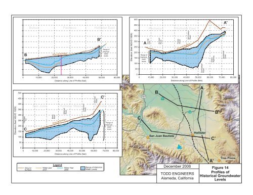
Elevation (feet NGVD 1929)<br />
500<br />
450<br />
400<br />
350<br />
300<br />
250<br />
200<br />
150<br />
100<br />
50<br />
B<br />
Bolsa Pacheco Hollister East<br />
Shore<br />
Road<br />
S<br />
R<br />
Calaveras<br />
Fault<br />
Ground Surface<br />
0<br />
0 10,000 20,000 30,000 40,000 50,000<br />
Distance along Line of Profile (feet)<br />
<strong>San</strong> Felipe<br />
Road<br />
Fairview<br />
Road<br />
B'<br />
Fallon<br />
Road<br />
Range of<br />
historical<br />
water<br />
levels<br />
60,000<br />
Elevation (feet NGVD 1929)<br />
500<br />
450<br />
400<br />
350<br />
300<br />
250<br />
200<br />
150<br />
100<br />
50<br />
A<br />
Range of<br />
historical<br />
water<br />
levels<br />
<strong>County</strong><br />
Line<br />
Pacheco Hollister East Tres Pinos<br />
Orchard<br />
Road<br />
Fallon<br />
Road<br />
0<br />
0 10,000 20,000 30,000 40,000 50,000 60,000 70,000<br />
McCloskey<br />
Road<br />
Ground Surface<br />
Sunnyslope<br />
Road<br />
Distance along Line of Profile (feet)<br />
Airline<br />
Highway<br />
A'<br />
Southside<br />
Road<br />
80,000<br />
Elevation (feet NGVD 1929)<br />
500<br />
450<br />
400<br />
350<br />
300<br />
250<br />
200<br />
150<br />
100<br />
50<br />
Highway<br />
101<br />
C<br />
<strong>San</strong> Juan Hollister West Hollister East<br />
Bixby<br />
Road<br />
Mitchell<br />
Road<br />
Ground Surface<br />
Calaveras<br />
Fault<br />
Fairview<br />
Road<br />
C'<br />
Range of<br />
historical<br />
water<br />
levels<br />
C<br />
B<br />
<strong>San</strong> Juan Bautista<br />
A<br />
Hollister<br />
C’<br />
B’<br />
0<br />
0 10,000 20,000 30,000 40,000 50,000 60,000 70,000<br />
Ground<br />
Surface<br />
<strong>Water</strong> year<br />
2007<br />
Distance along Line of Profile (feet)<br />
Legend<br />
<strong>Water</strong> Year<br />
2008<br />
Range of Historical<br />
<strong>Water</strong> Levels<br />
80,000<br />
December 2008<br />
TODD ENGINEERS<br />
Alameda, California<br />
A’<br />
Tres Pinos<br />
Figure 14<br />
Profiles of<br />
Historical Groundwater<br />
Levels