Soils, Natural Vegetation, and Wildlife - Department of Geography ...
Soils, Natural Vegetation, and Wildlife - Department of Geography ...
Soils, Natural Vegetation, and Wildlife - Department of Geography ...

Create successful ePaper yourself
Turn your PDF publications into a flip-book with our unique Google optimized e-Paper software.
3<br />
<strong>Soils</strong>, <strong>Natural</strong> <strong>Vegetation</strong>, <strong>and</strong> <strong>Wildlife</strong><br />
INTRODUCTION<br />
Combinations <strong>of</strong> physical processes, which are <strong>of</strong>ten modified<br />
through culture, create our ‘natural’ environment. Our environment<br />
consists <strong>of</strong> differing characteristics from the Tidewater<br />
to the Mountain Region. Daily, as well as seasonal, variations in<br />
weather help create an interesting, diverse, <strong>and</strong> ever changing<br />
l<strong>and</strong>scape. This chapter presents the soil, natural habitat <strong>and</strong><br />
vegetation, <strong>and</strong> wildlife distributions occurring throughout the<br />
state. These component parts <strong>of</strong> the physical environment play<br />
an important role in underst<strong>and</strong>ing a geographic perspective <strong>of</strong><br />
our state.<br />
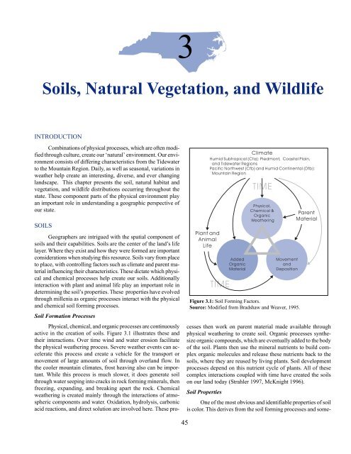
SOILS<br />
Figure 3.1: Soil Forming Factors.<br />
Source: Modified from Bradshaw <strong>and</strong> Weaver, 1995.<br />
Geographers are intrigued with the spatial component <strong>of</strong><br />
soils <strong>and</strong> their capabilities. <strong>Soils</strong> are the center <strong>of</strong> the l<strong>and</strong>’s life<br />
layer. Where they exist <strong>and</strong> how they were formed are important<br />
considerations when studying this resource. <strong>Soils</strong> vary from place<br />
to place, with controlling factors such as climate <strong>and</strong> parent material<br />
influencing their characteristics. These dictate which physical<br />
<strong>and</strong> chemical processes help create our soils. Additionally<br />
interaction with plant <strong>and</strong> animal life play an important role in<br />
determining the soil’s properties. These properties have evolved<br />
through millenia as organic processes interact with the physical<br />
<strong>and</strong> chemical soil forming processes.<br />
Soil Formation Processes<br />
Physical, chemical, <strong>and</strong> organic processes are continuously<br />
active in the creation <strong>of</strong> soils. Figure 3.1 illustrates these <strong>and</strong><br />
their interactions. Over time wind <strong>and</strong> water erosion facilitate<br />
the physical weathering process. Severe weather events can accelerate<br />
this process <strong>and</strong> create a vehicle for the transport or<br />
movement <strong>of</strong> large amounts <strong>of</strong> soil through overl<strong>and</strong> flow. In<br />
the cooler mountain climates, frost heaving also can be important.<br />
While this process is much slower, it does generate soil<br />
through water seeping into cracks in rock forming minerals, then<br />
freezing, exp<strong>and</strong>ing, <strong>and</strong> breaking apart the rock. Chemical<br />
weathering is created mainly through the interactions <strong>of</strong> atmospheric<br />
components <strong>and</strong> water. Oxidation, hydrolysis, carbonic<br />
acid reactions, <strong>and</strong> direct solution are involved here. These processes<br />
then work on parent material made available through<br />
physical weathering to create soil. Organic processes synthesize<br />
organic compounds, which are eventually added to the body<br />
<strong>of</strong> the soil. Plants then use the mineral nutrients to build complex<br />
organic molecules <strong>and</strong> release these nutrients back to the<br />
soils, where they are reused by living plants. Soil development<br />
processes depend on this nutrient cycle <strong>of</strong> plants. All <strong>of</strong> these<br />
complex interactions coupled with time have created the soils<br />
on our l<strong>and</strong> today (Strahler 1997, McKnight 1996).<br />
Soil Properties<br />
One <strong>of</strong> the most obvious <strong>and</strong> identifiable properties <strong>of</strong> soil<br />
is color. This derives from the soil forming processes <strong>and</strong> some-<br />
45
times is inherited from the parent material. <strong>Soils</strong> <strong>of</strong> the Tidewater<br />
<strong>and</strong> Coastal Plain are a mix <strong>of</strong> color, from the tans <strong>of</strong> s<strong>and</strong>s to<br />
a rich, dark color provided by high organic content, or humus,<br />
in some cases containing a black layer <strong>of</strong> peat (Photo 3.1). Piedmont<br />
soil colors vary, but one is dominant: red clay (CP 3.1). A<br />
form <strong>of</strong> iron, hematite, provides the red hue that has stained<br />
many children’s clothes through the years. The oxidation process<br />
<strong>of</strong> iron or aluminum in parent rock material generates this<br />
color. The Mountains provide a wide mixture <strong>of</strong> colors as physical<br />
weathering processes are vigorously at work. Valley floors<br />
contain the deepest soils <strong>and</strong> most have a dark brown color. The<br />
shallower soils that occupy the slopes <strong>and</strong> the ridges are similar<br />
in color, but without the same pr<strong>of</strong>ile.<br />
<strong>Soils</strong> also are classified or described by their particle size<br />
or texture. Texture classes are based on the proportions <strong>of</strong> s<strong>and</strong>,<br />
silt, <strong>and</strong> clay (expressed as percentages). Figure 3.2 is a Ternary<br />
diagram representation <strong>of</strong> the three components <strong>of</strong> soil used by<br />
the U.S. <strong>Department</strong> <strong>of</strong> Agriculture, allowing all soil to be classified.<br />
Texture is an important soil property as it determines water<br />
retention <strong>and</strong> transmission rates. For instance, s<strong>and</strong>y soils allow<br />
water to pass through rapidly, while clay soils have very small<br />
particles that do not allow water to pass through easily. Texture,<br />
as well as the organic content <strong>of</strong> the soil, can then be said to<br />
control soil moisture storage capacity, which is its ability to hold<br />
water against the pull <strong>of</strong> gravity. This in turn determines what<br />
plant life a soil might sustain or what might be an appropriate<br />
use <strong>of</strong> the l<strong>and</strong>.<br />
Mineral properties also are important characteristics <strong>of</strong> the<br />
soil’s personality. <strong>Soils</strong> in the state tend to be acidic due to the<br />
prevalence <strong>of</strong> granitic or gneissic parent material, the warm moist<br />
climate <strong>of</strong> the region, <strong>and</strong> the predominance <strong>of</strong> needle leaf forest<br />
vegetation. Most soils need heavy liming for agricultural productivity<br />
or for having a lush green lawn. In addition, soils may<br />
Figure 3.2: Soil Texture Classes.<br />
suffer from leaching <strong>of</strong> mineral nutrients, particularly nitrogen,<br />
phosphorus, potassium, calcium <strong>and</strong> magnesium, as a result <strong>of</strong><br />
excessive rainfall <strong>and</strong> warm temperatures. Preparation for agriculture<br />
through the application <strong>of</strong> fertilizers is necessary throughout<br />
the state.<br />
While most <strong>of</strong> us normally see only its top layer, a soil<br />
pr<strong>of</strong>ile is a valuable tool in underst<strong>and</strong>ing the total soil structure,<br />
including its depth. A pr<strong>of</strong>ile, that allows for the inspection<br />
<strong>of</strong> what lies beneath the surface, can be viewed readily by visit-<br />
Photo 3.1: An area <strong>of</strong> the Pamlico Peninsula<br />
in Tyrrell County has been<br />
cleared <strong>and</strong> drainage ditches excavated.<br />
<strong>Soils</strong> are dark <strong>and</strong> rich in humus<br />
<strong>and</strong> sometimes contain a layer<br />
<strong>of</strong> peat, which can also be used as a<br />
fuel source.<br />
46
ing new road cuts or construction sites. Each layer is a soil horizon,<br />
which is a distinctive layer <strong>of</strong> soil set apart from other layers<br />
by differences in physical or chemical composition, organic<br />
content, structure, or a combination <strong>of</strong> those properties. We see<br />
the color transitions from one horizon to the next. Figure 3.3<br />
illustrates a generalized soil pr<strong>of</strong>ile. Figure 3.4 describes a soil<br />
pr<strong>of</strong>ile from the Mountain region. Often these soils <strong>of</strong> complex<br />
terrain have thin horizons (5 cm/2 in) <strong>and</strong> overall soil depth is<br />
minimal. Topography <strong>and</strong> local relief additionally impact the<br />
soil development process, as shown in Figure 3.5.<br />
Spatial Extent <strong>and</strong> Distribution <strong>of</strong> <strong>Soils</strong><br />
CP 3.2 shows the spatial extent <strong>and</strong> distribution <strong>of</strong> the<br />
state’s soils. As with other physical features <strong>of</strong> the state, the east<br />
to west variation from the Tidewater to the Mountain regions<br />
continues.<br />
The Tidewater coastline consists <strong>of</strong> wide cusps or arcs in<br />
the southern half <strong>and</strong> a series <strong>of</strong> barrier isl<strong>and</strong>s in the northern<br />
half. L<strong>and</strong>scape features like these are a result <strong>of</strong> sediments being<br />
moved by <strong>of</strong>fshore currents as the coast slowly emerges (Box<br />
1B). Poorly drained areas, s<strong>and</strong> flats, bays, <strong>and</strong> sounds dominate<br />
the surface l<strong>and</strong> features. <strong>Soils</strong> <strong>of</strong> this region are relatively<br />
young, generally deep, over 91 cm (36 in), <strong>and</strong> <strong>of</strong> medium to<br />
fine texture. Differences in age <strong>and</strong> thickness are a result <strong>of</strong> various<br />
periods <strong>of</strong> erosion <strong>and</strong> deposition. Wet lowl<strong>and</strong>s or upl<strong>and</strong><br />
bogs (pocosins) are poorly drained with dark colored soils from<br />
decomposed vegetation. These soils belong to the soil order<br />
Histosol meaning “tissue soil”, from decayed plant remains.<br />
Figure 3.3: Soil Pr<strong>of</strong>ile <strong>and</strong> Horizons.<br />
Source: Modified from Bradshaw <strong>and</strong> Weaver, 1995.<br />
Figure 3.4: Designations <strong>of</strong> Horizons.<br />
Source: Modified from Bradshaw <strong>and</strong> Weaver, 1995.<br />
In the Coastal Plain Region, elevation gradually increases<br />
inl<strong>and</strong> to 91 meters (300 ft) above sea level. Here l<strong>and</strong> surface is<br />
characterized as gently rolling with prominent s<strong>and</strong> hills on the<br />
southwest margin. Most soils <strong>of</strong> the Coastal Plain are deep <strong>and</strong><br />
coarse or s<strong>and</strong>y in texture with heavier s<strong>and</strong>y clay subsoil, hence<br />
the “S<strong>and</strong>hills.” These <strong>and</strong> most <strong>of</strong> the Piedmont soils belong to<br />
the order Ultisols, which are very acidic, highly leached, <strong>and</strong><br />
weathered.<br />
Westward, the Piedmont consists <strong>of</strong> irregular rolling plains<br />
with local relief <strong>of</strong> 30 to 91 meters (100 to 300 ft). Elevations<br />
reach to 457 meters (1,500 ft) east <strong>of</strong> the Brevard Fault. As discussed<br />
earlier, the region is interrupted by erosional remnants<br />
<strong>and</strong> includes the Uwharrie, Sauratown, Kings, Brushy, <strong>and</strong> South<br />
mountains. Piedmont soils are generally over 91 cm (36 in) deep<br />
<strong>and</strong> have heavy, red or yellow clay sub-soils. They are relatively<br />
young due to recent erosion. Differences <strong>of</strong> soil depend mainly<br />
on the type <strong>of</strong> parent material. The Central Piedmont has considerable<br />
alfisol areas, a slightly acid soil derived from more<br />
basic rock.<br />
Topographic complexity <strong>of</strong> the Mountain Region creates<br />
many ‘micro’ environments in which plant <strong>and</strong> animal species<br />
can thrive. This region rises abruptly from the Piedmont along<br />
the Brevard Fault escarpment. The Blue Ridge Mountains comprise<br />
the eastern part <strong>of</strong> this region. Mountain soils tend to be<br />
young due to recent erosion <strong>and</strong> mass wasting on steep slopes<br />
caused by precipitation events. They tend to be shallower here<br />
than in the Piedmont as a result <strong>of</strong> cooler temperatures that re-<br />
47
duce the rate <strong>of</strong> parent material weathering. Sub-soils tend to<br />
have less heavy clay than the Piedmont soils. In broad valleys<br />
<strong>and</strong> basins, soils are more fertile <strong>and</strong> less leached; where a broadleaf<br />
forest dominates, humus is less acidic than in needle leaf<br />
forest. Steep ridges <strong>and</strong> higher mountain areas, especially on<br />
south facing slopes, have thin, acidic soils <strong>of</strong> the Inceptisol order.<br />
Figure 3.5 illustrates typical mountain soil characteristics<br />
<strong>and</strong> l<strong>and</strong>form types.<br />
Agricultural <strong>Soils</strong><br />
While the state’s future may lie in high tech industries, its<br />
tradition is agriculture. The majority <strong>of</strong> agricultural l<strong>and</strong>s are<br />
located within the Coastal Plain (CP 1.14). What makes the<br />
Coastal Plain well suited for agriculture? Certainly there is a<br />
complex interaction <strong>of</strong> many factors. The gentle slopes <strong>and</strong> the<br />
soil <strong>and</strong> its capacity to support plant life are dominant factors. A<br />
mixture <strong>of</strong> the right proportions <strong>of</strong> s<strong>and</strong>, silt, <strong>and</strong> clay coupled<br />
with the organic content <strong>of</strong> the soil, provides the foundation for<br />
prime agricultural l<strong>and</strong>s. This type <strong>of</strong> agricultural soil is generally<br />
referred to as loam (Figure 3.2), whose distribution dictate<br />
the most suitable agricultural areas <strong>of</strong> the state (CP 3.2); refer to<br />
CP 1.14 <strong>and</strong> note the coincidence <strong>of</strong> loamy soils to the areas<br />
currently in agricultural use. Additionally, climate (Figure 2.14),<br />
growing season (Figure 2.20), <strong>and</strong> availability <strong>of</strong> ground water<br />
(Figure 1.15) add to the formula <strong>of</strong> agricultural success. Photos<br />
3.2, 3.3, 3.4, <strong>and</strong> 3.5 give testament to the wide variety <strong>of</strong> agricultural<br />
activity in North Carolina, much <strong>of</strong> which is due to soil<br />
resources.<br />
As mentioned earlier, the use <strong>of</strong> soil for agriculture <strong>of</strong>ten<br />
requires input <strong>of</strong> fertilizer, particularly phosphorus <strong>and</strong> potassium.<br />
Application practices vary throughout the state <strong>and</strong> care<br />
should be taken to protect the surface <strong>and</strong> ground water supplies<br />
from the overuse <strong>of</strong> fertilizers; pollution readily occurs through<br />
run<strong>of</strong>f <strong>and</strong> infiltration processes.<br />
Figure 3.5: Mountain <strong>Soils</strong> <strong>and</strong> Topographic Influences.<br />
Source: Modified from Bradshaw <strong>and</strong> Weaver, 1995.<br />
Photo 3.2: Farml<strong>and</strong> <strong>of</strong> the Triassic<br />
Basin, a transitional<br />
zone between the Coastal<br />
Plain <strong>and</strong> Piedmont regions,<br />
in Harnett County. The l<strong>and</strong>scape<br />
takes on a patch like<br />
or quilted character, as fields<br />
<strong>of</strong> different crop types are intermixed<br />
with forested areas.<br />
Sedimentary rock providing<br />
the base for the soils <strong>of</strong> the<br />
region, <strong>and</strong> a long growing<br />
season, have given the area<br />
a longst<strong>and</strong>ing tradition <strong>of</strong><br />
agriculture. (photo by Robert<br />
E. Reiman)<br />
48
Photo 3.3: Strawberry fields are found nestled in<br />
the broad valleys <strong>of</strong> the Inner Piedmont Geologic<br />
Belt where soils are generally deeper <strong>and</strong><br />
<strong>of</strong>ten more fertile. This field is located in the<br />
South Mountains (Clevel<strong>and</strong> County) <strong>of</strong> the<br />
western Piedmont Region. Note the peach orchard<br />
on the back edge <strong>of</strong> the field.<br />
Photo 3.4: Apple orchards are common place in<br />
the Brushy Mountains <strong>of</strong> Wilkes <strong>and</strong> Alex<strong>and</strong>er<br />
Counties. Mountain soils <strong>and</strong> climate factors<br />
make the region a productive area for apple<br />
growth. This area recognizes the importance <strong>of</strong><br />
the crop by hosting the Apple Festival each fall.<br />
Photo 3.5: <strong>Soils</strong> <strong>of</strong> the Mountain Region vary<br />
within the complex terrain. Here an area near<br />
the Old Buffalo Trail (Watauga County) is<br />
being prepared for planting. Note the predominance<br />
<strong>of</strong> forest cover still surrounding<br />
this farm <strong>and</strong> the small size <strong>of</strong> the fields<br />
when compared to those <strong>of</strong> the Coastal Plain<br />
<strong>and</strong> Piedmont regions.<br />
49
NATURAL HABITATS AND VEGETATION<br />
As seen in Chapter One, forests provide the most widespread<br />
environmental feature <strong>of</strong> the state. However, North Carolina<br />
supports a great diversity <strong>of</strong> natural vegetation. This is due<br />
in part to the variety <strong>of</strong> climatic <strong>and</strong> topographic conditions or<br />
“habitats”, ranging from the moist, shaded coves <strong>of</strong> the Smokies<br />
to the exposed s<strong>and</strong> dunes <strong>of</strong> the barrier isl<strong>and</strong>s. Figure 3.6 displays<br />
the major vegetation types that are possible in the absence<br />
<strong>of</strong> human impact. Inevitably, people have played an important<br />
role in modifying or introducing vegetation (Box 3A), most noticeably<br />
in managing the pine forests <strong>of</strong> the Piedmont, Coastal<br />
Plain, <strong>and</strong> some <strong>of</strong> the Tidewater region. Pines are generally<br />
intolerant <strong>of</strong> shade <strong>and</strong> would be replaced by broadleaf trees as<br />
the climax vegetation in a natural succession. However, foresters<br />
have maintained pine for its commercial value by controlling<br />
broadleaf species <strong>and</strong> by planting or encouraging natural<br />
seeding <strong>of</strong> desired pine species. In the following discussion <strong>of</strong><br />
vegetation by regions, only the common plant names are used<br />
<strong>and</strong> readers who are interested should refer to Appendix B for<br />
their scientific name equivalents.<br />
Tidewater Habitats<br />
Along the easternmost edge <strong>of</strong> North Carolina are the barrier<br />
isl<strong>and</strong>s <strong>and</strong> outer banks, a thin chain <strong>of</strong> s<strong>and</strong>y beaches <strong>and</strong><br />
marshes. The barrier isl<strong>and</strong>s are situated between the pounding<br />
<strong>of</strong> the Atlantic Ocean to the east <strong>and</strong> the sounds <strong>of</strong> Currituck,<br />
Albemarle, Pamlico, Core, <strong>and</strong> Bogue (Photo 3.6) to the west.<br />
These are popular vacation destinations for millions <strong>of</strong> people<br />
who enjoy the sea air, gentle waves, <strong>and</strong> warm weather. Colder<br />
ocean currents from the north meet the warmer southern currents<br />
at Cape Hatteras <strong>and</strong> have made ocean travel treacherous<br />
in this area for centuries (Early 1993).<br />
Forming a series <strong>of</strong> graceful arcs, these barrier isl<strong>and</strong>s protect<br />
the mainl<strong>and</strong> from the destructive effects <strong>of</strong> powerful storms<br />
<strong>and</strong> their resulting waves (CP 3.3). Several theories regarding<br />
the formation <strong>of</strong> these isl<strong>and</strong>s are presented in Box 1B.<br />
Important wildlife habitats are found on the barrier isl<strong>and</strong>s<br />
<strong>and</strong> in nearby waters. Behind the dunes lie the maritime forests<br />
while on the western sides <strong>of</strong> the isl<strong>and</strong>s, fringing the sounds,<br />
salt marshes nurture countless numbers <strong>of</strong> fish, shellfish <strong>and</strong><br />
wildlife. Out on the shallow continental shelf not far from the<br />
isl<strong>and</strong>s, are underwater habitats known as “hardbottoms”, diverse<br />
communities <strong>of</strong> plants <strong>and</strong> animals. Rocky ledges provide<br />
shelter for fish <strong>and</strong> invertebrates whose only other homes are in<br />
the tropical coral reefs or on ship wrecks (Early 1993).<br />
Tidewater <strong>Vegetation</strong><br />
Strong winds, salt spray, shifting s<strong>and</strong>s, extreme heat, desiccation,<br />
<strong>and</strong> flooding create an inhospitable environment for<br />
vegetation adjacent to the coast (Photo 3.7). Only the hardiest<br />
plants can survive. Sea oats <strong>and</strong> American beach grass have been<br />
used extensively in an attempt to stabilize s<strong>and</strong> dunes. Increasing<br />
pressures from development have further complicated this<br />
environmentally sensitive area, <strong>and</strong> attempts to protect ocean<br />
front property have become a priority (Chapter 10). Other plants<br />
found on dunes include croton <strong>and</strong> dune elder. Broomsedge,<br />
spurge, <strong>and</strong> primrose are found in protected areas behind dunes;<br />
Figure 3.6: <strong>Natural</strong> <strong>Vegetation</strong>.<br />
50
all are plants less tolerant <strong>of</strong> salt spray. A maritime thicket <strong>of</strong><br />
yaupon, red cedar <strong>and</strong> wax myrtle <strong>of</strong>ten develops as an asymmetric<br />
mass to the lee <strong>of</strong> ocean winds along the inner dunes.<br />
Behind this thicket is a maritime forest dominated by live oak<br />
<strong>and</strong>, in the northern part, by beech <strong>and</strong> other broadleaf trees,<br />
holdovers from earlier periods when sea level was lower (CP<br />
3.4). Development has caused the loss <strong>of</strong> the majority <strong>of</strong> North<br />
Carolina’s maritime forests. Occasionally, an active dune will<br />
migrate <strong>and</strong> completely cover part <strong>of</strong> this forest. Where the dune<br />
moves on it leaves a stark reminder <strong>of</strong> previous life. Gnarled<br />
<strong>and</strong> wind swept branches are reminiscent <strong>of</strong> high mountain or<br />
arctic growth conditions (Photo 10.1).<br />
Along the sounds (protected by barrier isl<strong>and</strong>s) <strong>and</strong> in<br />
coastal bays are found vast areas <strong>of</strong> salt marsh characterized by<br />
cordgrass <strong>and</strong> needlerush. Freshwater marshes that are flushed<br />
by large coastal rivers, such as the Cape Fear, support bulrush,<br />
cattail, <strong>and</strong> sawgrass.<br />
Coastal Plain Habitat<br />
This low, flat region extends from the fall line toward the<br />
Atlantic Ocean; near the fall line elevations reach 152 meters<br />
(500 feet) above sea level. With so little slope <strong>and</strong> with little<br />
hard rock to flow through, the rivers entering the Coastal Plain<br />
form the rocky Piedmont me<strong>and</strong>er in broad, graceful loops<br />
through the s<strong>of</strong>t layers <strong>of</strong> s<strong>and</strong> (Early 1993).<br />
The s<strong>and</strong>y soils make it clear that the Coastal Plain was<br />
once wholly under water. Over the last two million years, the<br />
sea has inundated it many times, leaving a series <strong>of</strong> terraces across<br />
Photo 3.6: Bogue Sound in Carteret County,<br />
one <strong>of</strong> the smaller sounds, is protected<br />
by the barrier isl<strong>and</strong>s. Saltwater marshes<br />
thrive in the center <strong>of</strong> the narrow sound.<br />
Photo 3.7: As sediments reach the sounds they<br />
no longer can be carried by the rivers that<br />
brought them there <strong>and</strong> are deposited at the<br />
mouths <strong>of</strong> these rivers. Deposition creates<br />
a braided net <strong>of</strong> shallow waters <strong>and</strong> marsh<br />
vegetation. Here the Shalotte Inlet, in<br />
Brunswick County between Ocean Isle <strong>and</strong><br />
Holden Beaches, drains into Long Bay.<br />
Note the development on the bottom right<br />
<strong>of</strong> the photo. (Photo by Robert E. Reiman)<br />
51
Box 3A: Creeping, Climbing<br />
Kudzu.<br />
You are warned not to nap beside a southern roadside<br />
in summertime, or you might be covered in kudzu when you<br />
awake. There is a house in Chatam County obscured by the<br />
leafy vine, as well as a gas station in Dunn (Raleigh News<br />
<strong>and</strong> Observer 1997). Farm machinery <strong>and</strong> earth moving equipment<br />
are quickly covered by kudzu if left unattended.<br />
The U.S. Congress’ Office <strong>of</strong> Technology Assistance<br />
recently published a 390-page report on 4,500 species <strong>of</strong> exotic<br />
plants <strong>and</strong> animals that have been introduced into this<br />
country. The Associated Press quoted the project director as<br />
saying, “The economic <strong>and</strong> environmental impacts (<strong>of</strong> these<br />
exotic species) are snowballing...” Exotic species are those<br />
which have been relocated to a new environment. Many are<br />
transported accidentally, such as the tiger mosquito, which<br />
carries a virulent form <strong>of</strong> malaria. Others are brought purposefully<br />
for research, but are released accidentally, such as<br />
the African bee (killer bee). Often these exotic species are<br />
useful, but many become nuisances.<br />
One such plant species, kudzu, has been spreading<br />
across the southeastern U.S. for nearly 100 years, creating<br />
problems for farmers, foresters, telephone <strong>and</strong> power companies,<br />
<strong>and</strong> highway maintenance crews. It now covers more<br />
than two million acres <strong>and</strong> extends as far north as Illinois,<br />
Indiana, Ohio, Pennsylvania <strong>and</strong> New Jersey, <strong>and</strong> is still going.<br />
Its potential geographic range is as far north as Michigan,<br />
Wisconsin <strong>and</strong> the states <strong>of</strong> New Engl<strong>and</strong>.<br />
Several kudzu vines typically sprout from a single<br />
deep-rooted stem, which may reach two to four meters (six<br />
to twelve feet) underground. The vines have wide,<br />
three-pronged leaves <strong>and</strong> short-lived purple flowers during<br />
the summer. As the vines creep across the l<strong>and</strong>scape, roots<br />
may enter the soil anywhere the stem touches the ground.<br />
Additionally, wherever the vines contact trees, they will attach<br />
with root-like appendages <strong>and</strong> begin to climb. Because<br />
<strong>of</strong> the stem’s ability to “take root,” highway-mowing operations<br />
<strong>of</strong>ten help spread this plant to new sites by dragging<br />
pieces <strong>of</strong> vines into new areas.<br />
52
The plant evolved in the Orient, probably in China.<br />
Kudzu has been cultivated in China, Korea <strong>and</strong> Japan for<br />
1,000 or more years because <strong>of</strong> its hardiness <strong>and</strong> its usefulness<br />
as food, fibers <strong>and</strong> medicines. It was initially brought to<br />
the U.S. in the late 1800s as a decorative ornamental for<br />
porches <strong>and</strong> walls. Advertised as livestock feed well into the<br />
1930s <strong>and</strong> ’40s, kudzu was <strong>of</strong>ten promoted by the leading<br />
l<strong>and</strong> grant universities <strong>and</strong> agriculture schools in the Southeast.<br />
During the Depression, highway departments across the<br />
Southeast used kudzu to control erosion along road cuts or<br />
where roads were cut into hillsides. Today, across the Southeast,<br />
the largest <strong>and</strong> oldest expanses <strong>of</strong> kudzu follow the roads<br />
that were built during this period.<br />
Kudzu does have some positive qualities, though they<br />
are limited. As a l<strong>and</strong> cover, particularly where soil is poor<br />
<strong>and</strong> erosion prone, kudzu quickly covers the raw earth. Furthermore,<br />
the roots <strong>of</strong> kudzu nurture nitrogen-fixing bacteria<br />
that remove nitrogen from the air <strong>and</strong> place it in the soil.<br />
Although livestock will graze on the young leaves <strong>of</strong> kudzu<br />
in the spring, most will eat almost any other plant in preference.<br />
Only goats <strong>and</strong> hogs seem to truly thrive on kudzu foliage.<br />
The negative qualities <strong>of</strong> kudzu greatly overshadow the<br />
positive ones. Perhaps the most troublesome trait is the speed<br />
<strong>of</strong> the plant’s growth. Growth rates <strong>of</strong> six to twelve<br />
inches per 24-hour period are common. The plant’s rapid<br />
growth <strong>and</strong> canopy <strong>of</strong> foliage make it extremely competitive<br />
with virtually all other natural plant species; it even climbs,<br />
<strong>and</strong> kills, fully grown trees, particularly pines.<br />
Strong herbicides are not very effective in killing a mature<br />
kudzu plant. Since many roots enter the ground from<br />
various points along the stem, spraying <strong>of</strong> herbicides is seldom<br />
totally effective. Researchers at North Carolina State<br />
University are working to engineer some type <strong>of</strong> kudzu-eating<br />
bugs that they can safely introduce into the environment.<br />
It might be a bio-engineered soybean looper, a small hairless<br />
caterpillar, with an appetite enhanced for devouring kudzu<br />
(Raleigh News <strong>and</strong> Observer, 1997).<br />
Although kudzu is used to produce fibers, medicines,<br />
<strong>and</strong> foods in the Orient, few such aspects <strong>of</strong> the plant are<br />
utilized in the U.S. Most North Carolinians consider it a weed<br />
<strong>of</strong> the most terrible variety <strong>and</strong> treat it accordingly. Perhaps<br />
the best one can say about kudzu is that it has been the subject<br />
<strong>of</strong> numerous good jokes. One disenchanted former promoter<br />
<strong>of</strong> kudzu, in comparing the vine to his favorite dog,<br />
wrote, “It was like discovering Ole Blue was a chicken killer.”<br />
Modified from <strong>Geography</strong> in the News #261, Neal G. Lineback,<br />
Appalachian State University, October 22, 1993. Photos by Ole<br />
Gade.<br />
53
the l<strong>and</strong>scape to mark its advances. As recently as 18,000 years<br />
ago, the shoreline would have been many kilometers east <strong>of</strong><br />
where it is today (Figure 1.8).<br />
Great natural diversity exists within the Coastal Plain. Most<br />
<strong>of</strong> the states wetl<strong>and</strong>s - bald cypress swamps, deep peat bogs,<br />
freshwater marshes <strong>and</strong> the mysterious Carolina bays - occur in<br />
the Coastal Plain <strong>and</strong> Tidewater regions. Historically, the upl<strong>and</strong>s<br />
<strong>of</strong> the Coastal Plain were covered in longleaf pines <strong>and</strong><br />
scrubby oaks (Photo 3.8). Altered by natural <strong>and</strong> frequent fires<br />
through the centuries, Coastal Plain habitats have a rich diversity<br />
<strong>of</strong> plant <strong>and</strong> animal communities adapted to fire. S<strong>and</strong>hills<br />
longleaf pine forest is most notable in this respect. So common<br />
was fire that plants <strong>and</strong> animals developed many adaptations to<br />
resist, avoid, or even take advantage <strong>of</strong> it. Bottoml<strong>and</strong> hardwood<br />
forests, longleaf pine savanna, pocosin, <strong>and</strong> the unique Carolina<br />
Bays (Box 1D <strong>and</strong> Figure 11.6) cover other parts <strong>of</strong> the Coastal<br />
Plain (Early 1993).<br />
Coastal Plain <strong>Vegetation</strong><br />
The vegetation <strong>of</strong> this region also shows the impact <strong>of</strong><br />
human activity. Early settlement resulted in wide spread clearing<br />
for agriculture that produced a fine mosaic <strong>of</strong> l<strong>and</strong> cover. In<br />
recent decades many holdings have been consolidated, with additional<br />
l<strong>and</strong> being cleared <strong>and</strong> drained for large scale farming<br />
operations, while other areas show extensive reforestation <strong>of</strong><br />
pine for pulp <strong>and</strong> paper production. Of particular interest are the<br />
vast deposits <strong>of</strong> peat which underlie the Pamlico Peninsula, “fossil”<br />
swamp vegetation from eight to nine thous<strong>and</strong> years ago<br />
that may have great promise as an alternative source <strong>of</strong> energy.<br />
Its use, however, would have great environmental consequences.<br />
The physical setting <strong>of</strong> the Coastal Plains is generally favorable<br />
for vegetative growth, as a long frost-free season, ample<br />
moisture, good soils, <strong>and</strong> flat terrain characterize the region. Plant<br />
diversity is encouraged by differences in drainage conditions,<br />
depth to water table, soil types, <strong>and</strong> frequency <strong>of</strong> fire. Welldrained<br />
but moist sites <strong>of</strong> the Inner Coastal Plain have finely<br />
textured soils <strong>and</strong> are generally covered with an oak-hickory<br />
<strong>and</strong> loblolly pine forest similar to that in the adjacent Piedmont.<br />
However, coarsely textured soils <strong>of</strong> the S<strong>and</strong>hills area as well as<br />
the extreme southeast coast have open st<strong>and</strong>s <strong>of</strong> longleaf pine,<br />
an understory <strong>of</strong> scrub oaks, <strong>and</strong> a ground cover <strong>of</strong> wire grass.<br />
Longleaf pines develop deep taproots during the first three years<br />
<strong>of</strong> growth, while a grass-like cluster <strong>of</strong> needles at ground level<br />
withst<strong>and</strong>s the frequent fires. Then a rapid growth <strong>of</strong> its stem<br />
places needles <strong>and</strong> branches high enough to avoid fire damage.<br />
If fire were controlled, an oak hickory forest would soon replace<br />
the pines. Although fire destroys valuable timber, particularly<br />
in the southern Coastal plain, it can also be an important<br />
tool in managing the forest.<br />
Floodplains along the river courses support two types <strong>of</strong><br />
swamp forest. First, is a gum-cypress forest with high organic<br />
peaty soil that is almost continually under water. The second<br />
forest type is a broadleaf mixture <strong>of</strong> water oak, willow oak, sweet<br />
gum, ash, elm, sycamore, <strong>and</strong> river birch where soils usually<br />
dry out in summer months. An unusual wetl<strong>and</strong> vegetation, restricted<br />
to the North Carolina lower Coastal Plain, is known as<br />
“pocosin” from the Indian description “swamp on a hill” (Figure<br />
10.6). The pocosin evolved from the tidal sound environment<br />
as the coast was rising or as the sea receded. First, a swamp<br />
forest <strong>of</strong> cypress <strong>and</strong> gum developed; later, as thick deposits <strong>of</strong><br />
organic matter accumulated, soils became highly acid <strong>and</strong> deficient<br />
in nutrients. Fires occurred frequently until only a sparse<br />
growth <strong>of</strong> pond pine <strong>and</strong> dense shrubs was left. Similar vegetation<br />
dominates the Carolina Bays, elliptical depressions <strong>of</strong> the<br />
southern Coastal Plain (Box 1D).<br />
Occupying the flat areas between river courses in the southern<br />
Coastal Plain is savanna vegetation <strong>of</strong> pine flat woods.<br />
Coarser soils nurture a scattering <strong>of</strong> longleaf pine, a continuous<br />
ground cover <strong>of</strong> grasses, <strong>and</strong> a wide variety <strong>of</strong> wild flowers.<br />
Finer soils that are poorly drained support st<strong>and</strong>s <strong>of</strong> pond pine<br />
as well as the endemic Venus flytrap, found only in southeastern<br />
North Carolina! Again we find that frequent fires perpetuate this<br />
savanna area; otherwise shrubs <strong>and</strong> trees would naturally succeed.<br />
Photo 3.8: The Cape Fear River, as it flows through<br />
Harnett County in the Coastal Plain Region’s far<br />
western edge, has a mix <strong>of</strong> l<strong>and</strong> uses. The river<br />
bank is still forested, but encroachment <strong>of</strong> homes<br />
near a golf course communtiy is beginning.Note<br />
the gentle rapids on the southern section <strong>of</strong> the river.<br />
(photo by Robert E. Reiman)<br />
54
Piedmont Habitat<br />
Early settlers used the term “Piedmont”, meaning “foot<br />
<strong>of</strong> the mountain”, to refer to this region west <strong>of</strong> the fall line <strong>and</strong><br />
east <strong>of</strong> the Blue Ridge Mountains, because its s<strong>of</strong>tly rolling hills<br />
reminded them <strong>of</strong> their foothills homes in Europe. As rivers <strong>and</strong><br />
streams flow across the fall line, it is the resistant crystalline<br />
rocks that form the rapids <strong>and</strong> small waterfalls (as the river erode<br />
the less resistant sedimentary materials below) (Early 1993).<br />
Of all the regions in the state, the Piedmont has been most<br />
densely settled. Although the clay soils disappointed early settlers,<br />
the fast flowing rivers provided power for grist <strong>and</strong> textile<br />
mills <strong>and</strong> industry grew rapidly. Most <strong>of</strong> the state’s urban centers<br />
<strong>and</strong> population are located in the Piedmont, <strong>and</strong> it is the<br />
most important economic region <strong>of</strong> the state (Early 1993).<br />
Much less is left <strong>of</strong> the Piedmont’s natural communities<br />
than those <strong>of</strong> any other region in the state because the original<br />
mixed pine <strong>and</strong> hardwood forests were cut <strong>and</strong> the l<strong>and</strong> was<br />
farmed by the Europeans <strong>and</strong> by the native Americans before<br />
them. Topsoil has been denuded by decades <strong>of</strong> poor farming<br />
practices. As the farms became less productive, they <strong>of</strong>ten were<br />
ab<strong>and</strong>oned <strong>and</strong> succeeded by forests (CP 3.5, 3.6, 3.7) (Early<br />
1993).<br />
Piedmont <strong>Vegetation</strong><br />
A fine mosaic <strong>of</strong> forest <strong>and</strong> cultivated l<strong>and</strong> indicates the<br />
impact that people have had on vegetation in the Piedmont. Early<br />
settlers found a continuous oak-hickory forest on well-drained<br />
upl<strong>and</strong>s <strong>and</strong> a mixture <strong>of</strong> broadleaf species on the floodplains.<br />
As l<strong>and</strong> was cleared for agriculture <strong>and</strong> subsequently ab<strong>and</strong>oned,<br />
the growth <strong>of</strong> pines was favored. Pines dominate early stages <strong>of</strong><br />
natural succession, requiring much light <strong>and</strong> developing as an<br />
even-aged st<strong>and</strong>. However, they will eventually be replaced by<br />
broadleaf species if left unmanaged. The need for lumber <strong>and</strong><br />
pulpwood has enabled pines to dominate much <strong>of</strong> the Piedmont<br />
through forestry practices.<br />
Virginia pine occupies the western <strong>and</strong> northern sections<br />
<strong>of</strong> the Piedmont, short leaf pines the central section, <strong>and</strong> loblolly<br />
pine the eastern section <strong>of</strong> the Piedmont (CP 3.8). Soil <strong>and</strong> topographic<br />
differences account for the variety <strong>of</strong> hardwood species.<br />
Fertile, upl<strong>and</strong> sites favor southern red oak, white oak, <strong>and</strong><br />
mockernut hickory. A colorful under-story <strong>of</strong> dogwood <strong>and</strong> sourwood<br />
is common. Dry sites with thin soils support post oak,<br />
scarlet oak, <strong>and</strong> shagbark hickory. Sycamore, sweet gum, tulip<br />
poplar, willow oak, river birch, elm, <strong>and</strong> ash are common to<br />
floodplain areas. Some remnants <strong>of</strong> the mountain flora such as<br />
hemlock, white pine, <strong>and</strong> rhododendron occur in cool or elevated<br />
parts <strong>of</strong> the Piedmont, as is the case with Hanging Rock in Stokes<br />
County.<br />
Mountain Habitat<br />
The region <strong>of</strong> l<strong>of</strong>ty mountains from the Blue Ridge to the<br />
Tennessee border has the highest peaks <strong>and</strong> the greatest concentration<br />
<strong>of</strong> high elevations in the Southern Appalachians. National<br />
Forests cover vast expanses <strong>of</strong> the region <strong>and</strong> include the Pisgah<br />
<strong>and</strong> Nantahala. Great Smoky National Park also adds to these<br />
forest reserves. It is a region <strong>of</strong> spectacular waterfalls <strong>and</strong> gorges,<br />
with varying amounts <strong>of</strong> precipitation in the form <strong>of</strong> rain, mist,<br />
<strong>and</strong> snow (see Chapter 2). Trickling down from higher elevations<br />
are innumerable cold-water streams sheltering trout <strong>and</strong><br />
other aquatic life (Early 1993).<br />
The Mountain Region has a rich diversity <strong>of</strong> habitats, from<br />
rare bogs, to cove forests, to spruce-fir forests on the higher<br />
mountaintops. There are nearly 1,400 species <strong>of</strong> flowering plants<br />
in the region, including 85 native tree species (Early 1993).<br />
Mountain <strong>Vegetation</strong><br />
The Mountain Region displays two major types <strong>of</strong> vegetation,<br />
a broadleaf deciduous forest (CP 3.9, 3.10), at elevations<br />
up to 1,524 meters (5,000 feet), <strong>and</strong> a needle leaf evergreen<br />
forest or spruce-fir forest above that elevation (CP 3.11,<br />
3.12, 3.13). Also referred to as a boreal (northern) coniferous<br />
(cone-bearing) forest, this latter type resembles the vegetation<br />
<strong>of</strong> central Canada or the spruce-fir forests <strong>of</strong> New Engl<strong>and</strong> with<br />
red spruce <strong>and</strong> Fraser fir as dominant species. Fir is found on<br />
the highest exposed ridges <strong>and</strong> <strong>of</strong>ten develops a banner or<br />
“krumholz” (twisted tree) form caused by the exposure to the<br />
prevailing winds <strong>and</strong> to ice breakage. Extensive logging, fires<br />
<strong>and</strong> wind-throw have allowed growth <strong>of</strong> mountain ash, fire cherry<br />
<strong>and</strong> yellow birch. While the spruce-fir forest has declined dramatically<br />
in recent decades due to environmental changes that<br />
are poorly understood.<br />
On steep, south-facing gaps, a deciduous forest <strong>of</strong> beech,<br />
yellow birch, <strong>and</strong> sugar maple known as “northern hardwoods”<br />
<strong>of</strong>ten replaces the spruce-fir forest that is more sensitive to windthrow.<br />
However, the deciduous forest is best developed at lower<br />
elevations where conditions are ideal for large <strong>and</strong> dense growth.<br />
Cove forests contain a great variety <strong>of</strong> species including tulip<br />
poplar, yellow buckeye, cucumber tree, hemlock, white pine,<br />
beech, birch <strong>and</strong> maple. Rosebay rhododendron reaches tree size<br />
in some areas. On drier, exposed south-facing slopes, oaks dominate<br />
the forest, replacing the original American chestnut which<br />
covered up to eighty percent <strong>of</strong> the area before a blight was<br />
introduced in the mid-1920s. Various species <strong>of</strong> oak have different<br />
environmental needs <strong>and</strong> migrate towards elevation zones.<br />
Northern red oak dominates from 1,524 to 1,220 meters (5,000<br />
to 4,000 ft), chestnut oak from 1,220 to 915 meters (4,000 to<br />
3,000 ft), <strong>and</strong> white oak below 915 meters (3,000 ft). On most<br />
steep south or southwest-facing slopes <strong>and</strong> on dry open ridges<br />
pines <strong>and</strong> black locust are dominant, with mountain laurel <strong>and</strong><br />
blueberry providing a dense scrub layer. Fires <strong>and</strong> thin soils encourage<br />
this community to develop.<br />
The entire Mountain Region is not characterized by forest<br />
cover; in some places treeless “balds” have developed. A thick<br />
growth <strong>of</strong> mountain laurel <strong>and</strong> rhododendron or a cover <strong>of</strong> mountain<br />
oat grass dominate balds. How the balds are caused is not<br />
completely understood. Most likely they are due to a combina-<br />
55
tion <strong>of</strong> fire, windfall, <strong>and</strong> l<strong>and</strong>slides, along with human activities<br />
such as hunting <strong>and</strong> grazing <strong>of</strong> cattle. For many years in the<br />
early part <strong>of</strong> this century, it was a common practice to bring in<br />
cattle from the Tennessee valley to the west, fatten them on high<br />
mountain pastures during the summer, <strong>and</strong> then send them to<br />
the Piedmont for slaughter in the fall. It is said that the community<br />
<strong>and</strong> township <strong>of</strong> Meat Camp in Watauga County derived its<br />
name from that practice.<br />
WILDLIFE<br />
A variety <strong>of</strong> mammals, birds, <strong>and</strong> fish live within our l<strong>and</strong>scape.<br />
Given the state’s varying habitats, one finds an abundance<br />
<strong>of</strong> wildlife present throughout the state. As our l<strong>and</strong>scape is<br />
modified by spreading urbanization, reservoir construction <strong>and</strong><br />
other environment altering activities, our wildlife must adapt to<br />
survive or migrate to more appropriate habitats. However, not<br />
all wildlife adapts easily so while one species may flourish, others<br />
may suffer. Outdoor recreational pursuits include hunting,<br />
fishing, <strong>and</strong> boating. Protection <strong>of</strong> wildlife habitat from the<br />
marshes <strong>of</strong> the Tidewater to the forests <strong>of</strong> the Mountain Region<br />
is critical.<br />
Mammals<br />
Our state mammal is the gray squirrel. Squirrels seem abundant,<br />
as they appear plentiful in any city park on a spring day.<br />
However, the population <strong>of</strong> gray squirrel has been dwindling as<br />
hardwood forests, the best squirrel habitat, has been slowly converted<br />
through the years into pine forests. Squirrels adapt to many<br />
habitats, but do not always thrive in them. Adaptation is crucial.<br />
Rabbit numbers are also down as farmers eliminate brush piles<br />
<strong>and</strong> wooded lots for crops. Pesticide <strong>and</strong> herbicide uses that cause<br />
pollution are another factor effecting squirrel <strong>and</strong> rabbit populations.<br />
In 1910 deer populations numbered 10,000, in 1970 they<br />
numbered 300,000 <strong>and</strong> it has since more than tripled to 900,000<br />
in 1997 (Charlotte Observer 1999). What is the cause <strong>of</strong> the<br />
increase? Figure 3.7 illustrates the deer population <strong>and</strong> distribution.<br />
Simply stated, deer are very adaptable creatures. North<br />
Carolina’s checkerboard l<strong>and</strong>scape <strong>of</strong> forests, pastures, farms,<br />
developments, marshes, <strong>and</strong> water create a habitat in which deer<br />
can survive <strong>and</strong> thrive. Edge environments are critical to deer<br />
habitat. Great diversity <strong>of</strong> l<strong>and</strong> cover provides this edge environment<br />
<strong>and</strong> is better for deer. Yet, it is clear from 3.7 that deer<br />
habitats gradually improve from west to east.<br />
Black bear, on the other h<strong>and</strong>, require large expanses <strong>of</strong><br />
swamp or forests to survive (Figure 3.8). Compare the distribution<br />
<strong>of</strong> the bear populations with the pattern <strong>of</strong> l<strong>and</strong> cover (CP<br />
1.14). Note that the largest concentrations <strong>of</strong> black bear are found<br />
in the Coastal Plain <strong>and</strong> Mountain regions. Development, such<br />
as vacation homes, golf courses, <strong>and</strong> roads are diminishing the<br />
56<br />
Figure 3.7: White-Tailed Deer Harvest, 1998-99.<br />
Source: North Carolina <strong>Wildlife</strong> Resources Commission, 1999.
Figure 3.8: Black Bear Kill, 1998-99.<br />
Source: North Carolina <strong>Wildlife</strong> Resources Commission, 1999.<br />
Figure 3.9: Coyote Diffussion, 1988-1997.<br />
Source: Modified from the Charlotte Observer, 1999.<br />
bear’s habitat. While changing l<strong>and</strong>scape may provide useful<br />
habitat to one mammal, others may suffer or approach extinction.<br />
Coyotes have been sighted in our state, from the Tidewater<br />
to the Mountain regions. Figure 3.9 illustrates the spread or<br />
diffusion <strong>of</strong> coyotes throughout North Carolina. If this trend<br />
continues, coyotes will soon be present in every county.<br />
Beaver were abundant in the earlier years <strong>of</strong> settlement,<br />
were eradicated, were reintroduced in the 1940s, <strong>and</strong> today beaver<br />
are common in much <strong>of</strong> the state (Figure 3.10). It is not<br />
uncommon to see a beaver dam in the small northwestern mountain<br />
community <strong>of</strong> Beaverdam in Watauga County.<br />
Other recent reintroduction programs for mammals have<br />
been accomplished. These efforts have included the red wolf,<br />
which has been successfully reintroduced in the Tidewater region<br />
(Figure 3.11), while attempts to stabilize a population in<br />
the Smoky Mountains have failed. Road densities <strong>and</strong> road pattern<br />
seem to have a direct impact on the success <strong>of</strong> this reintroduction<br />
program. Roads create edge habitats that are a crucial<br />
source <strong>of</strong> food for the red wolf. The otter has been reintroduced<br />
to the western part <strong>of</strong> the state after they were forced to the eastern<br />
Piedmont <strong>and</strong> Coastal Plain regions, because <strong>of</strong> diminishing<br />
expanses <strong>of</strong> quality habitat.<br />
Wild boar were introduced to North Carolina in 1912, as<br />
14 European wild boars were released in a game preserve on<br />
Hooper’s bald in Graham County. After escaping from the preserve<br />
the wild boar established occupied ranges in some mountain<br />
counties (Figure 3.12). The first open hunting season was<br />
in 1936, <strong>and</strong> in 1979 the North Carolina Legislature designated<br />
the status <strong>of</strong> game animal to the wild boar. Figure 3.13 reflects<br />
the number <strong>and</strong> location <strong>of</strong> wild boar harvested during the 1998-<br />
99 hunting season (North Carolina <strong>Wildlife</strong> Resources Commission<br />
1999).<br />
Wild horses <strong>of</strong> the Outer Banks have been allowed to roam<br />
the range <strong>of</strong> a remote Carteret County isl<strong>and</strong> for decades <strong>and</strong><br />
they have thrived there. In 1995, an estimated 225 horses grazed<br />
the eight-mile long Shackleford Banks (part <strong>of</strong> the Cape Lookout<br />
National Seashore). Their populations have increased since<br />
sheep, goats, <strong>and</strong> cattle were removed in the mid-1980s, when<br />
the Park Service took over the l<strong>and</strong> for the national seashore.<br />
Concern for the horses has heightened as their increasing population<br />
has placed great stress on the habitat. Grasses that once<br />
grew to knee height are now eaten close to the ground level.<br />
Officials fear that food supplies will continue to dwindle <strong>and</strong><br />
horses may starve <strong>and</strong> die <strong>of</strong>f as they have on Carrot Isl<strong>and</strong> near<br />
Beaufort.<br />
Figure 3.10: Beaver Distribution, 1999.<br />
Source: North Carolina <strong>Wildlife</strong> Resources Commission, 1999.<br />
Figure 3.11: Red Wolf Distribution.<br />
Source: United States Fish <strong>and</strong> <strong>Wildlife</strong> Service, 1999.<br />
57
Figure 3.12: Wild Boar Distribution, 1999.<br />
Source: North Carolina <strong>Wildlife</strong> Resources Commission, 1999.<br />
Wild turkeys, with populations dwindling, were reintroduced<br />
through an active (3,565 birds since 1970) <strong>and</strong> somewhat<br />
costly restocking program (about $500 per restoration bird). Now<br />
the turkeys are flourishing. Populations have experienced dramatic<br />
increases since this program began. Only 2,500 birds existed<br />
in North Carolina in the early 1960s. Numbers increased<br />
to 7,500 in 1980, then to 28,000 in 1990, <strong>and</strong> in 1996 turkeys<br />
numbered more than 86,000 (Charlotte Observer 1996). Herds<br />
<strong>of</strong> over 100 birds have been seen in Watauga <strong>and</strong> Ashe Counties<br />
(CP 5.19). In North Carolina 95 <strong>of</strong> the 100 counties have wild<br />
turkey populations (Figure 3.14). Wild turkeys provide a popular<br />
game bird during the fall season, as hunters work their distinctive<br />
calls <strong>of</strong> gobbling in hopes <strong>of</strong> attracting a bird. As will be<br />
seen in Chapter 5, the domesticated cousin <strong>of</strong> this bird has also<br />
contributed to the state economy. North Carolina is the number<br />
one turkey producer in the nation. Hunters also find the morning<br />
dove a popular game bird, though this bird along with grouse<br />
<strong>and</strong> quail have experienced declines.<br />
Bald eagles have made a comeback since the banning <strong>of</strong><br />
DDT. Only one nesting site was known in the state in 1972; in<br />
1995, there were 12 known sites <strong>and</strong> in early 1999 there are<br />
over 20 sites. Seven breeding pairs were in the northeastern part<br />
<strong>of</strong> the state, nesting in Pasquotank, Chowan, Washington, Hyde,<br />
Beaufort, Tyrrell, <strong>and</strong> Dare counties (Raleigh News & Observer<br />
1995). North Carolina, South Carolina, <strong>and</strong> Virginia have made<br />
intensive efforts to increase the population <strong>of</strong> our nation’s sym-<br />
Figure 3.13: Wild Boar Harvest, 1998-99.<br />
Source: North Carolina <strong>Wildlife</strong> Resources Commission, 1999.<br />
Birds<br />
A multitude <strong>of</strong> song birds find habitat in our state, <strong>and</strong> the<br />
cardinal is designated as our state bird. However, as the large<br />
forested areas dwindle, so do the populations <strong>of</strong> the birds that<br />
need this habitat to thrive. Over the past 25 years, nearly 20<br />
species <strong>of</strong> bird populations have declined. The loggerhead shrike,<br />
a forest dwelling bird, is down 95 percent, while meadowlarks,<br />
mockingbirds, <strong>and</strong> blue jays are down 53, 45, <strong>and</strong> 38 percent<br />
respectively. At the same time, bluebirds have increased 369<br />
percent; cowbirds, 301 percent; <strong>and</strong> robins, 75 percent; these<br />
birds favor forest edges, which are created or enhanced with<br />
road cuts <strong>and</strong> construction (Charlotte Observer 1990).<br />
Figure 3.14: Wild Turkey Harvest, 1998.<br />
Source: North Carolina <strong>Wildlife</strong> Resources Commission, 1999.<br />
bol; unless people interfere again, the eagles are back to stay.<br />
Not as lucky as the eagle is the red-cockaded woodpecker,<br />
a bird heading toward possible extinction. In 1989, Hurricane<br />
Hugo ripped through the nations second largest population in<br />
the Francis Marion National Forest in South Carolina. About<br />
450 birds died <strong>and</strong> most <strong>of</strong> the rest were left without viable habitat.<br />
Now work is continuing to restablish a viable habitat in the<br />
S<strong>and</strong>hills (see Chapter 11). <strong>Natural</strong> disasters can have a dramatic<br />
impact on habitat quality: hurricanes devastate large areas<br />
while the tornadoes impact a much smaller area (Chapter 2).<br />
Fish <strong>and</strong> Turtles<br />
Fresh <strong>and</strong> saltwater fish provide a valuable economic <strong>and</strong><br />
recreational resource for our state. Our shores are blessed with<br />
barrier isl<strong>and</strong>s, hundreds <strong>of</strong> miles <strong>of</strong> inl<strong>and</strong> shoreline, sounds<br />
<strong>and</strong> estuaries, all providing habitat for a diverse saltwater fish<br />
population. Inl<strong>and</strong>, the surface waters <strong>of</strong> our state provide many<br />
excellent recreational opportunities as well (see Chapter 10).<br />
Over-fishing <strong>and</strong> dams have reduced the striped bass fisheries<br />
in the Coastal Plain region. However, in mountain rivers<br />
reintroduced muskies have made a comeback since the removal<br />
<strong>of</strong> some dams (Charlotte Observer 1990).<br />
Trout, which are abundant in many <strong>of</strong> the state’s rivers,<br />
suffer because <strong>of</strong> increasing development near their habitat. De-<br />
58
velopment activities may release sediment that flows into<br />
streams; this process <strong>of</strong> sedimentation can kill trout. Road, resort,<br />
<strong>and</strong> golf course development, if done improperly, devastates<br />
trout stream quality. Additionally, the clearing <strong>of</strong> forest<br />
which once shaded the waters <strong>and</strong> kept them cold are no longer<br />
there to protect the water from warming by the sun. Increasing<br />
the temperature <strong>of</strong> the water decreases the trout population. Agricultural<br />
introduction <strong>of</strong> fertilizering compounds in streams<br />
through run<strong>of</strong>f will also decrease water quality.<br />
Loggerhead turtles find the shores most suitable for nesting<br />
from May through August. These turtles have found it increasingly<br />
difficult to thrive in the rapidly developing coastal<br />
areas. Representatives at Brunswick County’s Turtle Watch Program<br />
estimate that only about 100 turtles reach adulthood for<br />
every 7,000 eggs laid. Newborn turtles are attracted to the brightest<br />
lights; years ago that light was moonlight, which lead them<br />
to the ocean. However, lights from nearby modern development<br />
attract the newborn turtles inl<strong>and</strong> to their demise. Predators such<br />
as raccoons, snakes, <strong>and</strong> ants also find the turtle’s eggs a tasty<br />
food source.<br />
59
Orange<br />
North Carolina’s Place<br />
in the World<br />
CANADA<br />
U N<br />
I T E<br />
S T A T E S<br />
D<br />
North Carolina’s<br />
Place in the<br />
United States<br />
MEXICO<br />
Currituck<br />
Camden<br />
Physiographic Regions<br />
<strong>and</strong> Counties <strong>of</strong><br />
North Carolina<br />
Mountain Region<br />
Piedmont Region<br />
Coastal Plain Region<br />
Tidewater Region<br />
Iredell<br />
Surry Stokes<br />
Yadkin<br />
Rowan<br />
Cabarrus<br />
Stanly<br />
Union Anson<br />
Richmond<br />
Montgomery<br />
Moore<br />
Mecklenburg<br />
Harnett<br />
Halifax<br />
Northampton<br />
Edgecombe<br />
Pitt<br />
Hertford<br />
Bertie<br />
Martin<br />
Gates<br />
Pasquotank<br />
Chowan<br />
Hoke<br />
Person<br />
Brunswick<br />
Nash<br />
Durham<br />
Robeson<br />
Wake<br />
Johnson<br />
Sampson<br />
Bladen<br />
Columbus<br />
Franklin<br />
Warren<br />
Alamance<br />
Granville<br />
Vance<br />
Cherokee<br />
Graham<br />
Clay<br />
Swain<br />
Macon<br />
Haywood<br />
Jackson<br />
Madison Yancey<br />
Buncombe<br />
Henderson<br />
Polk<br />
Avery<br />
McDowell<br />
Rutherford<br />
Burke<br />
Ashe<br />
Caldwell<br />
Alleghany<br />
Watauga Wilkes<br />
Rockingham<br />
Transylvania<br />
Alex<strong>and</strong>er<br />
Davie<br />
Forsyth<br />
Davidson<br />
Perquimans<br />
Cumberl<strong>and</strong><br />
Scotl<strong>and</strong><br />
Guilford<br />
R<strong>and</strong>olph<br />
Caswell<br />
Mitchell<br />
Catawba<br />
Lincoln<br />
Gaston<br />
Chatham<br />
Lee<br />
Wilson<br />
Wayne<br />
Duplin<br />
Pender<br />
Greene<br />
Lenoir<br />
New<br />
Hanover<br />
Jones<br />
Onslow<br />
Craven<br />
Beaufort<br />
Pamlico<br />
Carteret<br />
Tyrell<br />
Hyde<br />
Dare<br />
Clevel<strong>and</strong><br />
Color Plate 1.1: North Carolina’s World, Regional, <strong>and</strong> Local Settings.<br />
61