Coastal Plain Region - Department of Geography and Planning
Coastal Plain Region - Department of Geography and Planning
Coastal Plain Region - Department of Geography and Planning

You also want an ePaper? Increase the reach of your titles
YUMPU automatically turns print PDFs into web optimized ePapers that Google loves.
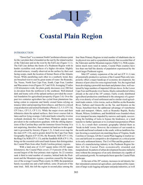
Photo 11.1: In some cases river rapidshave been bypassed by theprovision <strong>of</strong> locks, <strong>and</strong> places farinl<strong>and</strong> have benefited by this advancein river transportationtechnology. Shown here is thelower Lock No. 1 <strong>of</strong> the two thathave been constructed along theCape Fear River to provide improvedriver access toFayetteville, located 140 milesupstream from the AtlanticOcean. Rapids can be seen adjacentto the lock, which raises/lowers ships ten feet.as the growth <strong>of</strong> labor intensive manufacturing industries, especiallycotton textiles. Benefiting initially as nodes in the exp<strong>and</strong>edrail network were Fayetteville, Rocky Mount, Goldsboro, <strong>and</strong>Wilson (CP 11.1). However, the essential isolation from majormarkets continued. Without further incentives for major investmentsuntil the hayday <strong>of</strong> the military bases during <strong>and</strong> followingWorld War II, settlement <strong>and</strong> town development peaked formost <strong>of</strong> the region’s counties in the early part <strong>of</strong> the 20 th century.Consequently today’s cultural l<strong>and</strong>scape is dominated by traditionalfarm assemblages <strong>and</strong> small towns where time seems tohave stood still for most <strong>of</strong> the past century. For example, many<strong>of</strong> the region’s larger urban places have skylines dominated by afew six to ten story “skyscrapers,” built to house banks <strong>and</strong> hotelsduring the more ebullient decades surrounding the turn <strong>of</strong>the 20 th century. In no city in the <strong>Coastal</strong> <strong>Plain</strong> has the urbanrenewal process <strong>of</strong> the 1960s, the bane <strong>of</strong> historic preservationin many Piedmont cities, cleared out what might now be consideredto be architectural jewels <strong>of</strong> public buildings, commercialbusiness districts, <strong>and</strong> residential neighborhoods (Photos 11.2<strong>and</strong> 11.3; CP 11.2a-d). Dominated by human-scale <strong>and</strong> historicarchitecture, as well as by aesthetically designed <strong>and</strong> maintainedneighborhoods, most <strong>Coastal</strong> <strong>Plain</strong> towns now exude a tranquilitythat belies the hectic social <strong>and</strong> economic pace at the beginning<strong>of</strong> the new millennium. Many urban places define the concept<strong>of</strong> residential aesthetics by their sweeps <strong>of</strong> Queen Annes,Painted Victorian Ladies, Greek <strong>and</strong> Tudor Revivals, SouthernColonials, <strong>and</strong> Bungalows sitting amidst towering trees <strong>and</strong> generousopen green spaces.As is the case for all <strong>of</strong> the regional chapters <strong>of</strong> this text,the information presented here is organized in the following order:(1) a survey <strong>of</strong> critical natural l<strong>and</strong>scape features, (2) consideration<strong>of</strong> natural-human environmental interface characteristicsthat are more or less specific to the <strong>Coastal</strong> <strong>Plain</strong>, <strong>and</strong> (3) asurvey <strong>of</strong> the dominant individual state geographic regions. Asindicated earlier, for some <strong>of</strong> these geographic regions there aresignificant overlaps with the adjacent state primary regions <strong>of</strong>the Tidewater <strong>and</strong> the Piedmont, <strong>and</strong> critical information pertainingto all <strong>of</strong> this primary state region is dispersed throughoutthe thematic chapters <strong>of</strong> this text for the reader’s perusal. It isunfortunate that this region <strong>of</strong> North Carolina has not capturedthe interest <strong>of</strong> recent writers <strong>of</strong> regional geography, history, <strong>and</strong>political economy, though the more specialized topic <strong>of</strong> regionalarchitecture is well covered by Bishir <strong>and</strong> Southern (1996). Itshould be noted that on the county level there are numerous countyhistories, though <strong>of</strong> varying detail <strong>and</strong> foci. Residents <strong>of</strong> Moore<strong>and</strong> Robeson counties are fortunate in the recent availability <strong>of</strong>very thoroughgoing <strong>and</strong> well illustrated descriptive county atlases(Ross 1994 <strong>and</strong> 1996).THE NATURAL LANDSCAPEL<strong>and</strong> Surface DevelopmentThe plain’s surface evolved through a complexity <strong>of</strong> geologicchange over several hundred million years. By the end <strong>of</strong>the Triassic Period, about 190 million years ago, vast sedimentshad been deposited, accompanied by intrusions <strong>and</strong> block faultingin the earth’s crust. Following a lowering <strong>of</strong> the surface some100 million years ago, the Cretaceous Sea covered the plain.There followed an extended period <strong>of</strong> marine depositioninterbedded with s<strong>and</strong>s, marls, <strong>and</strong> clays before the plain wasagain uplifted to form the present <strong>Coastal</strong> <strong>Plain</strong> surface. The slowprocess <strong>of</strong> uplift resulted in the positioning <strong>of</strong> a series <strong>of</strong> sixterraces (Figure 10.8). Sea level changes during the PleistoceneIce Age have further aided in shaping these terraces, with theirescarpments facing the ocean, <strong>and</strong> with their gentle slope l<strong>and</strong>-385
Photos 11.2 <strong>and</strong> 11.3: Before the turn <strong>of</strong> the 20 thcentury a magnificent eight story hotel wasbuilt on the corner <strong>of</strong> Walnut <strong>and</strong> Centerstreets in the heart <strong>of</strong> Goldsboro (WayneCounty), complemented a few decades laterby the Paramount Movie Theater on theopposite side <strong>of</strong> Center Street. These weresymbols <strong>of</strong> the good times afforded by tobacco,an early manufacturing concentration,that also included the first large furnitureplant in the state, <strong>and</strong> excellent rail connections.A double wide Center Street subsequentlyresulted from covering the tracks<strong>of</strong> the Atlantic Coast Line Railroad, whichwith Southern Railroad <strong>and</strong> the Atlantic <strong>and</strong>East Carolina Railroad, intertwined in theheart <strong>of</strong> downtown. With the 1960s <strong>and</strong> 70soutmigration <strong>of</strong> retail <strong>and</strong> residences to thesuburbs downtown Goldsboro declined inattractiveness for investors <strong>and</strong> consumers,<strong>and</strong> the hotel went out <strong>of</strong> business. It <strong>and</strong>many other buildings fell into disrepair. Anew perspective on the future <strong>of</strong> downtowncurried by excitement over the potential success<strong>of</strong> nearby Global TransPark developmenthas energized the historic revitalizationeffort. The once again splendid buildingsst<strong>and</strong> as testimony to the city’s vision<strong>of</strong> its future (Compare to Photo 6.11).ward. The terraces can be identified readily where traversed bythe major rivers, as for example, on the Roanoke River near Scotl<strong>and</strong>Neck, on the Cape Fear River near Fayetteville, <strong>and</strong> on theNeuse River near Goldsboro. Here, for example, Cliffs <strong>of</strong> theNeuse State Park provides evidence <strong>of</strong> how the Neuse River haseroded the Black Creek Formation <strong>of</strong> Cretaceous vintage to 100feet below the high points on the cliffs (CP 11.3). Dig deep enough<strong>and</strong> the more ancient <strong>and</strong> harder rocks <strong>of</strong> the Piedmont appear,as demonstrated by the existence <strong>of</strong> a granite quarry near thevillage <strong>of</strong> Fountain in Pitt County, far from the Fall Line. A moreconvenient place to explore the surface meeting <strong>of</strong> the crystallinerocks <strong>of</strong> the Piedmont <strong>and</strong> the sedimentary rocks <strong>of</strong> the<strong>Coastal</strong> <strong>Plain</strong> is at Medoc Mountain State Park in western HalifaxCounty.Medoc Mountain was named for the famous French commercialvine region, the Medoc, due to extensive vineyardsfounded in this part <strong>of</strong> Halifax County in the mid-19 th Century bythe noted farmer <strong>and</strong> wine educator, Sidney Weller. The ‘Mountain’itself is a north-south trending ridge, elevated up to 160 feet(50 meters) above the plain surface, its northern <strong>and</strong> westernslopes rising steeply over a distance <strong>of</strong> a quarter <strong>of</strong> a mile. MedocMountain is a biotite granitic outcrop <strong>of</strong> the crystalline surface<strong>of</strong> the Piedmont. Displaced but few miles east <strong>of</strong> the Fall Line, itis more resistant to erosive processes than the surrounding s<strong>of</strong>terCretaceous s<strong>and</strong> <strong>and</strong> clay strata. Although from this perspectiveMedoc Mountain qualifies as a monadnock (see Chapter 1), itreally is a part <strong>of</strong> the more generally defined Fall Zone, demarcatingthe l<strong>and</strong>form transition from Piedmont to <strong>Coastal</strong> <strong>Plain</strong>386
conditions. Raven Rock State Park on the Cape Fear River inHarnett County provides a similar example <strong>of</strong> the abrupt changein geomorphology from the <strong>Coastal</strong> <strong>Plain</strong> to the Piedmont (Photo11.4).The S<strong>and</strong>hills State Geographic <strong>Region</strong> (Figure 9.11) derivesits name from a physiographically distinctive area in thesouthwestern part <strong>of</strong> the <strong>Coastal</strong> <strong>Plain</strong>. With its more gently undulating<strong>and</strong> hilly surface configuration, the S<strong>and</strong>hills differs fromthe almost uniformly flat surface features <strong>of</strong> the remainder <strong>of</strong> the<strong>Coastal</strong> <strong>Plain</strong>. The Orangeburg scarp marks a transition createdby wave cuts during the Pliocene some five million years ago(Cabe <strong>and</strong> Reiman 1996). Surface materials comprising theS<strong>and</strong>hills were deposited at an earlier time, some 90 million yearsago in the case <strong>of</strong> the Middendorf Formation (Late CretaceousPeriod) <strong>and</strong> 45 million years ago, in the case <strong>of</strong> the PinehurstFormation (Eocene Epoch <strong>of</strong> the Tertiary Period; see Figure 1.8).More recent Pinehurst materials, distinctively s<strong>and</strong>y in nature<strong>and</strong> presently heavily mined, overlie the Middendorf’s more consolidatedclayey s<strong>and</strong>s <strong>and</strong> frequently comprises the upper reaches<strong>of</strong> the hills. The transition from the soils <strong>of</strong> the S<strong>and</strong>hills to those<strong>of</strong> the Piedmont may be observed by comparing CP 1.5 with CP3.1 further west in Moore County. Elevations range from 270 to600 feet generally east to west. On its western <strong>and</strong> northern edge,the S<strong>and</strong>hills clearly differentiate from the Piedmont’s more ruggedappearance. Here igneous <strong>and</strong> metamorphic rock <strong>of</strong> the Carolina<strong>and</strong> Eastern slate belts control surface configurations; Figures1.5, 1.6 <strong>and</strong> 10.8 illustrate these basic relations on this westernS<strong>and</strong>hills extension <strong>of</strong> the <strong>Coastal</strong> <strong>Plain</strong>.Rivers pass over the plain topography at an average gradient<strong>of</strong> only 0.6 feet per mile, as compared to their traverse overthe Piedmont surface, where, for example, the upper Cape Fearaverages out to a gradient <strong>of</strong> two feet/mile. Such a fairly uniform,gentle slope has encouraged a parallel drainage system(Figure 11.2). The very low gradient has also resulted in extensiveinterior floodplains <strong>and</strong> wetl<strong>and</strong> areas. Exemplifying the complexity<strong>and</strong> size <strong>of</strong> these drainage basins is school principalFigure 11.2: Generalized Drainage Pattern <strong>of</strong> Major StreamsCrossing the <strong>Coastal</strong> <strong>Plain</strong>.Needham Bryan Cobb’s 1887 tally <strong>of</strong> the Roanoke tributaries, apoetic contribution designed to entice rote memorization by elementaryschool pupils, so including only those tributaries thatempty into that great river from North Carolina:“Wolf Isl<strong>and</strong> <strong>and</strong> Marrows, Town, Hogan <strong>and</strong> Show,And Neilman <strong>and</strong> Double, two prongs <strong>of</strong> Hyco,And Big, Mill <strong>and</strong> Moon (these names are no jokes),From Rockingham, Caswell, Person <strong>and</strong> Stokes;And Bearskin <strong>and</strong> Nutbush, from Granville <strong>and</strong>Vance,Big Grassy, Big Isl<strong>and</strong> <strong>and</strong> Jonathan’s pranceWith Sassafras, Gardener’s <strong>and</strong> long County LineKehukee, Skewarkee <strong>and</strong> old S<strong>and</strong>y Run.”(Arthur 1995, 14)Photo 11.4: Raven Rock State Park is the location <strong>of</strong> thisstriking quartzite <strong>and</strong> slate overhang that dramatizesthe change in geomorphology from the sedimentaryrock materials <strong>of</strong> the <strong>Coastal</strong> <strong>Plain</strong> to the Piedmont’smix <strong>of</strong> geologic base rocks. Here Raven Rock risesover 100 feet above the upper reaches <strong>of</strong> the CapeFear River, hidden by the trees in the left <strong>of</strong> the photo,some 15 miles north <strong>of</strong> Lillington, Harnett County.The rock was a noted l<strong>and</strong>mark for pilots <strong>of</strong> steamersplying the river from Fayetteville to Haywood inChatham County through the system <strong>of</strong> locks <strong>and</strong>dams built by the Cape Fear <strong>and</strong> Deep River NavigationCompany beginning in 1854.387
Absent in other notable physical features, the <strong>Coastal</strong> <strong>Plain</strong>frequently sees its rivers provide administrative boundaries formany <strong>of</strong> its counties, as well as sites for urban places.Atmospheric InfluencesAmong the various weather extremes attained within thestate, <strong>and</strong> depicted in Box 2B, only the monthly average dailymaximum <strong>of</strong> 110ºF, reached at Fayetteville in 1983, falls withinthe <strong>Coastal</strong> <strong>Plain</strong>. Generally, the plain is free from temperature<strong>and</strong> moisture extremes, a positive condition for agriculture. Springtends to come earlier to the S<strong>and</strong>hills due to the loose, friable,<strong>and</strong> well-drained soils that warm rapidly over a day <strong>of</strong> cloudlesssky. Earliest state flowering dates <strong>of</strong> redbud <strong>and</strong> dogwood treesoccur in the S<strong>and</strong>hills (Figure 11.3). But the earlier the flowering,the greater the danger for a damaging late frost.Occasionally weather plays morbid tricks on the region.Hurricanes can dump 15 inches or more <strong>of</strong> precipitation during apassage <strong>and</strong> cause severe flooding, a major problem for agricultureas well as for the region’s towns. Hurricane Fran in 1996caused an estimated $1 billion in damages to agricultural facilities,fields, as well as animal <strong>and</strong> crop production. In September<strong>of</strong> 1999, the drenching rains <strong>of</strong> Dennis, having been degraded toa tropical storm, were followed a couple <strong>of</strong> weeks later by theeven more devastating Hurricane Floyd (note the detailed discussion<strong>and</strong> illustrations provided in CP 8.1-8.8). Eight inches<strong>of</strong> Dennis’ precipitation topped <strong>of</strong>f river <strong>and</strong> ground water levels;then came Floyd’s fifteen inches over a 24 hour period. TheTar River exemplified the record <strong>Coastal</strong> <strong>Plain</strong> flood levels. OnSeptember 18, the river crested at 34 feet at Tarboro, fifteen abovenormal flood level. The lower lying town <strong>of</strong> Princeville, on theopposite bank, was by then twelve feet under the water (CP 11.4a to c). With the very gentle gradient <strong>of</strong> the plain insuring a slowmovement <strong>of</strong> flood waters toward the sounds <strong>and</strong> the ocean, theflood crest <strong>of</strong> the Neuse River at Kinston was not reached until afull week later. How physical features <strong>of</strong> the <strong>Coastal</strong> <strong>Plain</strong> contributedto making this flood the largest disaster in the state’shistory is well developed by Paul Gares (1999). Incredibly, Dennis<strong>and</strong> Floyd were followed on October 16 by Hurricane Irene,though this storm was by far the most benign <strong>of</strong> the three, causingmeasurable damage only in the Lower Cape Fear area. Resultsfrom the flood boggles the mind: 51 people dead; 43,000damaged homes, <strong>of</strong> which 15,000 became uninhabitable; 30,000damaged farms with 100,000s <strong>of</strong> drowned livestock, especiallyhogs, turkeys <strong>and</strong> chickens; burst or overflowing hog waste lagoons;21 flooded waste water treatment plants; 241 disinterredc<strong>of</strong>fins; <strong>and</strong> 70,000 people seeking recovery support (Zagier2000, 9-10)Tornadoes used to be thought <strong>of</strong> as being more dramaticas localized environmental hazards; certainly they can be equallytraumatic. A extreme example, possibly the worst ever in the state,was the March 28, 1984 storm that spawned many tornadoes <strong>and</strong>caused destruction throughout the <strong>Coastal</strong> <strong>Plain</strong>. In North Carolina,fourteen counties were hit, 51 people died <strong>and</strong> 691 wereinjured, <strong>and</strong> 1,407 homes were destroyed (Figure 11.4). Figure2.14 provides further evidence that Tornado Alley is an appropriatemoniker for this stretch <strong>of</strong> <strong>Coastal</strong> <strong>Plain</strong>. Its extensive flatterrain, <strong>of</strong>fering little resistance to the winds, is more frequentlyvisited by this devastating natural hazard than is any other part<strong>of</strong> the state.Vegetative Cover <strong>and</strong> Wetl<strong>and</strong>sTrees dominated the natural vegetative cover <strong>of</strong> the <strong>Coastal</strong><strong>Plain</strong>, as may be expected from the humid subtropical climate(see Chapters 2 <strong>and</strong> 3). Now only 50 to 60 percent <strong>of</strong> most <strong>of</strong> thecounties are tree covered, as agriculture <strong>and</strong> urbanization haveexacted their share <strong>of</strong> forest clearance (compare Photos 3.2 <strong>and</strong>3.8). A great variety <strong>of</strong> hardwoods <strong>and</strong> Loblolly pine are sovereignon upl<strong>and</strong> surfaces, except in the S<strong>and</strong>hills State Geographic<strong>Region</strong> where longleaf pine is in preponderance, <strong>and</strong> where, infact, the counties <strong>of</strong> Moore <strong>and</strong> Montgomery approach 80% forestcover (CP 3.8). In wetl<strong>and</strong> areas, vegetative cover is morecomplex, <strong>and</strong> much more interesting (Figure 3.6).Upl<strong>and</strong> ForestsA mature upl<strong>and</strong> hardwood forest, considered to be at least50 years <strong>of</strong> uninterrupted growth, is represented mostly by members<strong>of</strong> the oak family; here there are a pr<strong>of</strong>usion <strong>of</strong> chestnutoaks, mixed with white, black <strong>and</strong> northern red varieties.Mockernut hickories <strong>and</strong> red maples are present, as well. A diverseunderstory is dominated by blueberry <strong>and</strong> huckleberryshrubs. In places where fields are no longer cultivated or grazed,pine will dominate the transition to an upl<strong>and</strong> hardwood forest.Several pine species figure importantly among the earlier transitionblackberry thickets <strong>and</strong> juniper. Pulp <strong>and</strong> paper companiesnow own extensive acreage <strong>of</strong> upl<strong>and</strong>s where they manage <strong>and</strong>harvest loblolly pine plantations. Before there were loggers inthe S<strong>and</strong>hills there was an almost uniform cover <strong>of</strong> virgin longleafpine. With the decimation <strong>of</strong> the longleaf, second growth forestbecame dominated by loblolly <strong>and</strong> slash pines. Both <strong>of</strong> these arenow managed on private property as short-term rotated pulp <strong>and</strong>chip wood (see CP 5.20a-c).Figure 11.3: Average Flowering Dates for Redbud <strong>and</strong> Dogwood.Source: Reader, et al (1974).388
Figure 11.4: Tornado Alley. Passage <strong>of</strong> the March 28, 1984 Tornadoes.Source: Charlotte Observer, 1 April, 1984.Bottoml<strong>and</strong> Hardwood ForestsBottoml<strong>and</strong> forests or wooded wetl<strong>and</strong>s is also referredto more formally as riparian/alluvial forested wetl<strong>and</strong>s. They occuralong all <strong>of</strong> the main rivers traversing the <strong>Coastal</strong> <strong>Plain</strong>. Muchvariation exists among the vegetation in these wetl<strong>and</strong>s, but commonalitiesinclude a strong linear form aligned adjacent to a corridorfor the transport <strong>of</strong> water <strong>and</strong> erosional materials, as wellas a critical connection with upstream <strong>and</strong> downstream ecosystems(Adams et al 1994, 36-38). Bottoml<strong>and</strong> forests act as importantbuffers between the flow <strong>of</strong> rivers <strong>and</strong> their interfluves;with their fluctuating water regime these forests have a high inherentlevel <strong>of</strong> productivity for aquatic species. They are especiallysupportive for fish spawning during overbank flooding inlate winter <strong>and</strong> early spring. They are highly regarded as wildlifehabitat, notably for white-tailed deer <strong>and</strong> wild turkey, <strong>and</strong> tendto have a high concentration <strong>of</strong> bird life, frequently includingpileated woodpeckers, wood ducks, white breasted nuthatches,<strong>and</strong> barrel owls (Venters 1995, 20). Often these are the only remainingtracts <strong>of</strong> forest remaining in a region overcut for agricultureor development, <strong>and</strong> thereby they become important avenuesfor wildlife. They also provide critical services to downstreamecosystems, by slowing flow <strong>of</strong> waters during flood stage,by trapping excess sediment, <strong>and</strong> by lifting organic materialsduring floods <strong>and</strong> making them available for the estuarine foodchain. All <strong>of</strong> this protects the salinity levels in estuary fish <strong>and</strong>shellfish spawning grounds <strong>and</strong> nurseries.Characteristic <strong>of</strong> tree species inhabiting the wetl<strong>and</strong>s forestare those that adapt well to seasonal flooding <strong>and</strong> have toleranceto anaerobic conditions. Bald cypress <strong>and</strong> water tupelo dominatein the wettest areas (Figure 11.5 ). Where the water flowsmore swiftly, <strong>and</strong> where higher banks <strong>and</strong> narrower channelsexist, a different vegetative complex occurs. Here there may be agreater concentration <strong>of</strong> American elm, red maple, sycamore,sweet gum, green ash, laurel oak, swamp cottonwood, waterhickory, water oak, sugarberry, river birch, Shumard oak, overcupoak, cherrybark oak, <strong>and</strong> others. While black willows <strong>and</strong> riverbirches may overhang the stream, natural levees may see a concentration<strong>of</strong> small pawpaws <strong>and</strong> swamp chestnut oak. On thesteeper banks, American beech <strong>and</strong> mountain laurel dominate.389
Bottoml<strong>and</strong> hardwood forests in the Albemarle-Pamlicoriver basins were in a 1990s study calculated to cover about twothirds <strong>of</strong> the state total <strong>of</strong> this kind <strong>of</strong> wetl<strong>and</strong>. Conversion toother uses has been occurring at a rapid rate. Still the Albemarle-Pamlico area itself is one <strong>of</strong> the largest <strong>and</strong> least disturbed bottoml<strong>and</strong>sforest ecosystem remaining along the mid-Atlantic region.Here is the summer habitat <strong>of</strong> important migratory birds,like the ruby-throated hummingbird that wings its way from acrossthe Gulf <strong>of</strong> Mexico, the cerulean warbler that over-winters inPeru, <strong>and</strong> the prothonotary warbler that does the same in Venezuela.The birds share the ecosystem with the striped bass <strong>and</strong>the hickory shad spawning below Roanoke Rapids in HalifaxCounty. These are anadromous fish who in their life cycle returnfrom the ocean, from as far away as Newfoundl<strong>and</strong>, to spawnclose to the Fall Line. Water rushing <strong>of</strong>f a series <strong>of</strong> rock ledgesoxygenates the water <strong>and</strong> creates conditions favorable for egghatching <strong>and</strong> the survival <strong>of</strong> the hatchlings. The Roanoke Riveris once again considered a mecca for fishing, <strong>and</strong> fishermen <strong>and</strong>environmentalists take heart from the success <strong>of</strong> the recent fifteen-yeareffort in restoring bass <strong>and</strong> shad to the formerly deadriver. Even so, the river fails to flood as once it did. A sequence<strong>of</strong> dams impounds the river <strong>and</strong> affects stream flow. A personinterested in observing the character <strong>of</strong> the bottoml<strong>and</strong> forestmay visit the Roanoke River National Wildlife Refuge, parallelingthe Roanoke along US 13/17 north <strong>of</strong> Williamston into BertieCounty.On the Neuse River, below Smithfield in Johnston Countythere is an extensive bottoml<strong>and</strong>s forest dominated by cypress<strong>and</strong> gum trees (clearly noticeable on Piedmont Triangle l<strong>and</strong> covermap in Chapter 12) These wetl<strong>and</strong>s are dominated by wide swathsin the l<strong>and</strong>scape created by a me<strong>and</strong>ering Neuse River, in placesso bent up on itself due to the very gradual decrease in elevationthat many oxbow lakes have resulted. Variously referred to asthe ‘Let ‘Lones’, a name likely derived from the area’s capability<strong>of</strong> sheltering or hiding hermits <strong>and</strong> bootleggers, the NeuseLakes, the Marshes, or the Low Grounds, these wetl<strong>and</strong>s are consideredone <strong>of</strong> the most significant natural areas along the NeuseRiver by state biologists (Shiffer 1998).Seasonal Wetl<strong>and</strong>s <strong>and</strong> the Carolina BaysForested wetl<strong>and</strong> areas, where poor drainage <strong>and</strong> high watertables develop an appearance <strong>of</strong> ponded water for extended periodsduring the year, are referred to as nonriparian forested wetl<strong>and</strong>s,a form <strong>of</strong> nonriverine swamp forest. Frequently, they occurnear the edge <strong>of</strong> large peatl<strong>and</strong>s, grading into pocosins towardthe interior <strong>of</strong> the peatl<strong>and</strong>s, as on much <strong>of</strong> the PamlicoPeninsula (Figure 10.6). More <strong>of</strong>ten, however, they occur in depressionsthat periodically collect <strong>and</strong> store excess water drainingfrom elevated surroundings. Temporary wetl<strong>and</strong>s are normallynot very deep <strong>and</strong> tend to disappear during the warm seasonwith its higher rate <strong>of</strong> evaporation. In their most peculiarform, they comprise most <strong>of</strong> the ecosystems <strong>of</strong> the Carolina bays(Figure 11.6); wetl<strong>and</strong>s in this form cover most <strong>of</strong> Bladen County(see CP 1.16a <strong>and</strong> b, <strong>and</strong> Box 1D). Like all wetl<strong>and</strong> communitiesthe majority <strong>of</strong> the Carolina bays store water <strong>and</strong> release it graduallyinto stream <strong>and</strong> lakes, thus reducing peak flows.Fluctuating water levels contribute to a peculiar combination<strong>of</strong> flora <strong>and</strong> fauna. While there are not many rare plant speciesfound in seasonal wetl<strong>and</strong>s, they do appear critical to thesurvival <strong>of</strong> a number <strong>of</strong> amphibians. Rare tiger salam<strong>and</strong>ers <strong>and</strong>gopher frogs breed in these wetl<strong>and</strong>s due to the absence <strong>of</strong> theamphibians’ more significant predators (fish). By breeding in wintertheir young develop before st<strong>and</strong>ing water disappears in spring,but their proliferation does attract wading birds such as the greatblue heron.These wetl<strong>and</strong>s are especially vulnerable to exploitation,in part due to their excellent soils. They are easily ditched <strong>and</strong>drained, providing promising l<strong>and</strong>s for agriculture <strong>and</strong> forestry.Deciding what is a wetl<strong>and</strong> <strong>and</strong> what is not is particularly frustratingwhen soils <strong>of</strong> an area are only seasonally wet. This canFigure 11.5: Bottoml<strong>and</strong>s Hardwood Forest.Source: Venters (1995, p. 21); illustration by Anne Runyon, by permission.390
Figure 11.6: Seasonal Wetl<strong>and</strong>s.Source: Venters (1995, p. 21); illustration by Anne Runyon, by permission.become a contentious issue in the interpretation <strong>of</strong> federal <strong>and</strong>state regulations regarding the use <strong>of</strong> wetl<strong>and</strong>s, especially wherethese are owned by paper companies who like to manage themfor loblolly pine plantations. Most seriously affected by largescale conversion to managed timberl<strong>and</strong>s are the seasonal wetl<strong>and</strong>s<strong>and</strong> pocosins <strong>of</strong> Green Swamp in Brunswick County(Moorhead 1995). Though the Carolina bays have seen a reduction<strong>of</strong> over half <strong>of</strong> their acreage over the years, it remains possibleto inspect aspects <strong>of</strong> this ecosystem at Bladen Lakes StateForest, <strong>and</strong> at the state parks <strong>of</strong> Jones Lake <strong>and</strong> Singletary Lake,also in Bladen County. CP 10.31 well displays the Carolina Baysl<strong>and</strong> surface <strong>of</strong> shrubl<strong>and</strong>s intermingled with forest <strong>and</strong> water inBladen County <strong>and</strong> in the Green Swamp <strong>of</strong> Columbus County(CP 11.5).North Carolina has empowered its Environmental ManagementCommission to establish wetl<strong>and</strong>s rules <strong>and</strong> the <strong>Department</strong><strong>of</strong> Environment <strong>and</strong> Natural Resources’ Division <strong>of</strong> WaterQuality to enforce these rules. In an earlier day, this was the responsibility<strong>of</strong> the Army Corps <strong>of</strong> Engineers. In 1996, the Commissioninitiated a ban on the ditching <strong>and</strong> draining <strong>of</strong> wetl<strong>and</strong>sfor development, when it appeared that the federal courts mightstrike down the wetl<strong>and</strong>s rules <strong>of</strong> the Corps. This actually occurredin the summer <strong>of</strong> 1998. Unhappily, it took the state morethan nine months to begin enforcement <strong>of</strong> the Commission’s ban,<strong>and</strong> during this period 15,000 to 20,000 acres <strong>of</strong> wetl<strong>and</strong>s weredrained by developers in the southeastern part <strong>of</strong> the state, thoughmostly in Brunswick County. While developers are contemplatingsuing the Commission for reinstatement <strong>of</strong> their presumedright to drain <strong>and</strong> reclaim their l<strong>and</strong>s as they see fit, GovernorHunt, in September <strong>of</strong> 1999, asked for restoration <strong>of</strong> the illegallydrained <strong>and</strong> ditched wetl<strong>and</strong>s.THE NATURAL–HUMAN ENVIRONMENT INTER-FACEL<strong>and</strong> Use <strong>and</strong> Wetl<strong>and</strong>s Environmental Management IssuesMajor <strong>Coastal</strong> <strong>Plain</strong> l<strong>and</strong> use issues seem to stem mostlyfrom concerns over wetl<strong>and</strong>s preservation, the drainage <strong>of</strong> lowlying areas, <strong>and</strong> use <strong>of</strong> river courses for the actual or potentialdumping grounds <strong>of</strong> sewage, agricultural chemicals, animal <strong>and</strong>human wastes, or other pollutant forms. Extensive areas lie withinfloodplains <strong>and</strong> are especially vulnerable to most forms <strong>of</strong> humanuse, as dramatized by the 1999 Hurricane Floyd floodingdamage. Some <strong>of</strong> the l<strong>and</strong> use issues have developed into seriouscontroversies involving the private sector, local communities,special interest groups, <strong>and</strong> the state <strong>and</strong> federal governments.Conflicts over appropriate l<strong>and</strong> use are also more frequentlyengaged where, as in the siting <strong>of</strong> the Nucor Steel plant<strong>and</strong> the proposed Wisconsin Tissue mill, the issue seems to boildown to public financial support for private industries locatingin environmentally sensitive areas <strong>of</strong> counties seriously laggingstate norms in economic development.391
The Water Pipeline ControversyLake Kerr, Lake Gaston, <strong>and</strong> Roanoke Rapids Lake, aresequenced dammed lakes along the Roanoke River as it crossesfrom Virginia into North Carolina. Some 70 miles to the east liesNorfolk-Virginia Beach, Virginia’s largest metropolitan area,where overdevelopment has caused a frequent municipal needto ordain severe water use restrictions. For twenty years therehad been an ongoing controversy whether water, some 60 milliongallons per day, could or should be pumped through a proposed76 mile pipeline from Lake Gaston to the Virginia metropolisto aid in alleviating the perennial water shortages. Upstreamusers in both states contend that they should have a say inthe use <strong>of</strong> Roanoke River basin water due to its economic <strong>and</strong>environmental importance. The users had been moving a casethrough the court system to block the pipeline. The federal government<strong>and</strong> court system continued to uphold both the ArmyCorps <strong>of</strong> Engineers’ pipeline permit <strong>and</strong> the Federal Energy RegulatoryCommission’s approval <strong>of</strong> withdrawal <strong>of</strong> water from lakescreated for hydroelectric power. Meanwhile, Virginia Beach completedthe pipeline at a cost <strong>of</strong> $150 million, <strong>and</strong>, declaring a faitacompli, began tapping the water in November <strong>of</strong> 1997 (Allegood1997). While the opponents will continue the challenge to the U.S. Supreme Court, it is notable that the water draw down constitutesonly about one percent <strong>of</strong> average daily river flow at thepoint <strong>of</strong> the draw. The Roanoke carries the largest amount <strong>of</strong>water among North Carolina’s great rivers. In its traverse fromthe Blue Ridge Mountains in the west, the river drains over 10,000square miles <strong>of</strong> Virginia <strong>and</strong> North Carolina l<strong>and</strong>s.A Steel Mill on the Chowan RiverHuge clusters <strong>of</strong> bald cypress line the Chowan River as itsdark waters slowly ease their way from the Virginia boundary totheir confluence with the Albemarle Sound. As its estuary broadens,the river forms an increasingly wide water boundary betweenHertford <strong>and</strong> Bertie counties in the <strong>Coastal</strong> <strong>Plain</strong> <strong>Region</strong><strong>and</strong> Gates <strong>and</strong> Chowan counties in the Tidewater <strong>Region</strong>. Heavymoisture-ladened air infused with the earthy sweet-sour aromas<strong>of</strong> swamps <strong>and</strong> forested wetl<strong>and</strong>s hangs over a sixty mile stretch<strong>of</strong> river unbroken by human habitation except for a few survivingfish camps. Where the river once gave life to an abundance<strong>of</strong> freshwater finfish, decades <strong>of</strong> pollution <strong>and</strong> overfishing exhausteda valuable resource. In the early 1970s, gross environmentalmismanagement at a fertilizer plant located at Trenton inHertford County caused massive nutrient pollution. Chowan Rivereutrification, algal blooms, <strong>and</strong> fish kills were the result <strong>of</strong> whatbecame the state’s first major warning <strong>of</strong> several decades <strong>of</strong> environmentaldisaster events for its rivers (see Chapter 5). Groundwaterat the former site <strong>of</strong> the fertilizer plant, since declared aNational Superfund site, is still contaminated. With stronger environmentalcontrols the Chowan River now appears to be movingtoward recovery.Nucor Corporation, a leading national steel recycler, wasgranted state permits in early 1999 to build a $360 million steelplate manufacturing plant on a 900 acre site adjacent to theChowan River. Expected to be the largest <strong>of</strong> its kind in the UnitedStates in tonnage <strong>of</strong> sheet steel produced, the mill is designed toeventually manufacture up to 1.5 million tons yearly (CP 11.6).The site is a few miles downstream <strong>of</strong> the former pesticide plant.Notably, in spite <strong>of</strong> the wilderness nature <strong>of</strong> the site <strong>and</strong> much tothe anguish <strong>of</strong> environmental, wildlife, <strong>and</strong> fisheries groups, thiswas done without a comprehensive environmental impact statement.The state found itself in a bind as state Commerce <strong>Department</strong><strong>and</strong> local industrial recruitment <strong>of</strong>ficials fought to bring aplum in industrial investment to the Roanoke, the poorest stategeographic region. Nucor responded positively to the state’s <strong>of</strong>fer<strong>of</strong> $161 million in tax write-<strong>of</strong>fs <strong>and</strong> other financial incentives(Henderson 1998). Some 800 workers prepared the site<strong>and</strong> built the plant, which went on line in 2001. A 300 plus personpermanent labor force work there, at an average salary <strong>of</strong>$60,000, about three times the current average salary <strong>of</strong> HertfordCounty residents. So while the North Carolina taxpayer is, ineffect, subsidizing the location <strong>of</strong> this mill at a cost <strong>of</strong> about$535,000 per job generated, we may expect considerable returnsto the locality <strong>and</strong> its region.Of course, locally most people are overjoyed at the prospects<strong>of</strong> high paying permanent jobs to be generated directly bythis industry. For well-trained manufacturing workers, presentlycommuting 180 miles round trip to their work places in the Norfolkmetro region, this <strong>of</strong>fers a potential for stable at-home employment.The plant will noticeably strengthen the local tax basein a poor county where the property tax is more than 25 percenthigher than in wealthy Mecklenburg County. With higher expectations<strong>of</strong> newly affordable local service, <strong>and</strong> with an ability toprovide a much needed influx <strong>of</strong> investment in upscale housing,residents may experience considerable improvement in education,health, shopping, <strong>and</strong> overall community wellbeing.Particular environmental concerns regarding the Nucorplant’s location include: 1) daily transportation <strong>of</strong> scrap metalby barge through waters previously confined mostly to recreationalbass fishermen; 2) expected release <strong>of</strong> some 6,800 tons<strong>of</strong> air pollutants per year, mostly in the form <strong>of</strong> sulphur dioxide,decreasing visibility <strong>and</strong> potentially harming the Swan QuarterNational Wildlife Refuge 65 miles to the southeast; 3) the majorneed for clean water in the production process will require theplant to draw up to a million gallons <strong>of</strong> groundwater daily froman area where local wells periodically are running dry; 4) a riveralready overloaded with nutrients might be further troubled bythe anticipated nitrogen oxide emissions; <strong>and</strong> 5) long term impactson air <strong>and</strong> water quality, scenic areas, <strong>and</strong> wildlife in themill’s vicinity, by the mill <strong>and</strong> by other firms magnetized intotheir location by the Nucor facilities.A Paper Recycler on the Roanoke RiverEnvironmentalists are asking whether the Roanoke River,where fish are once again returning to spawn, is the appropriateplace for a new paper recycling plant. The proposed site <strong>of</strong> a392
Chesapeake Corporation’s Wisconsin Tissue plant is a few milesdownstream from Weldon, where it will have a daily intake <strong>of</strong>three million gallons <strong>of</strong> river water very close to the favoritespawning area for the American <strong>and</strong> hickory shad, <strong>and</strong> the stripedbass. Concerns also focus on the potential for renewed river degradationwith the waste water from the paper plant. This is anexample <strong>of</strong> the traditional <strong>and</strong> agonizing issue <strong>of</strong> attracting newindustries into environmentally vulnerable regions that qualifyfor extraordinary state <strong>and</strong> local location incentives due to theirrelatively large unemployment <strong>and</strong> poverty. As Charlotte Observercorrespondent Jack Betts (1999) has noted, “Are jobs alwaysthe trump card when environmental questions arise?” LikeHertford County, Halifax is one <strong>of</strong> twelve North Carolina countiesrated Tier 1-economically distressed (Figure 9.14). Thus itqualifies for $12,500 in tax credits for each new employee, a$1,000 tax credit for each employee receiving job training, plusa seven percent investment tax credit for new machinery. In toto,$30 million in state support may be available for the building <strong>of</strong>a $180 million mill with an anticipated 155 jobs with an average$30,000 yearly salary. When fully operational the mill might employ800 workers. Since the plant is to be sited on Mush Isl<strong>and</strong>,an area that for a decade has been pushed by environmental groupsfor inclusion in a federally managed wildlife preserve, it is particularlynotable that an environmental impact statement (EIS)has not been required by the state. An EIS would outline <strong>and</strong>document the potential adverse effects on the environment <strong>and</strong>on local communities from the siting <strong>of</strong> a facility. It evaluates thecognate <strong>and</strong> cumulative effects, looks at alternatives, <strong>and</strong> requirespublic hearings. However, in the Wisconsin Tissue case, as wellas in the Nucor steel mill case an EIS was not initially requiredby the state, raising a serious concern regarding future decisions<strong>of</strong> a similar nature. Subsequently, Wisconsin Tissue has volunteeredto comply with the EIS expectation, but now it is uncertainthat the Chesapeake Corporation will, in fact, locate its planthere!The Neuse River — Surely We Can Do Better!In Colonial days the Neuse River provided a communication<strong>and</strong> commerce artery from the Pamlico Sound to the fallline. Barges <strong>and</strong> steamboats established a <strong>Coastal</strong> <strong>Plain</strong> heartline that influenced the location <strong>of</strong> New Bern, Kinston, Goldsboro,<strong>and</strong> Smithfield. Well into the 20 th Century pine logs were floateddownstream to sawmills in New Bern. Then increasing developmentpressures began to degrade water quality. An absence <strong>of</strong>appropriate buffer zones in areas <strong>of</strong> heavy residential constructionactivities, especially along creeks that empty into the 230mile river within the Piedmont Triangle <strong>Region</strong>, was contributingmassive concentrations <strong>of</strong> pollutants to the Neuse. So wasthe run<strong>of</strong>f from logging <strong>and</strong> agriculture taking place too close tothe streams <strong>of</strong> the river basin. Add to that the problem <strong>of</strong> 200plus identified point sources <strong>of</strong> pollution, mostly treated <strong>and</strong> untreatedwaste water pipes that fed into the river or its tributaries.Subsequently the Neuse suffered the impact <strong>of</strong> chronic leaks <strong>and</strong>spills from the waste lagoons <strong>of</strong> a hog industry that explodedduring the 1990s without much regard to its environmental implications.An excess <strong>of</strong> nutrients, mostly nitrogen <strong>and</strong> phosphates,created a fertile brew that provided a positive environment forthe flourishing <strong>of</strong> the fish killer phisteria (see Chapter 5). Therancid smells drove away users <strong>of</strong> the river. By the mid-1990s,the Neuse River was dying. In response to a suit brought againstthe state by the Neuse River Foundation, the U.S. EnvironmentalProtection Agency (EPA) was placed in a position to compelthe state to comply with a provision in the national Clean WaterAct that called for a maximum total daily load <strong>of</strong> individual contaminants.With a goal <strong>of</strong> reducing pollution in the Neuse RiverBasin by some 30 percent, government inspectors would have tomore carefully identify the sources <strong>of</strong> ammonia gas from swinewaste lagoons that would return as pollution in rain through theNeuse estuary. Already stricter regulations cover the emission <strong>of</strong>sewage from municipalities <strong>and</strong> factories, <strong>and</strong> the EPA has agreedto a state imposed cap on the total daily amount <strong>of</strong> nitrogen pollutionflowing from fertilizers, animal waste <strong>and</strong> every othersource. Perhaps soon the new “River Keeper” <strong>of</strong> the Neuse, aposition created in 1993, will be seeing the river once again populatedby nature’s bounty <strong>and</strong> by contented recreational fishermen(Peters 1995).A Success Story <strong>of</strong> River Protection — The LumberIn the mid-1980s, residents <strong>of</strong> the Lumber River basin werealarmed to find that a site on the river was being considered forthe location <strong>of</strong> a hazardous waste treatment plant that would dischargeabout half a million gallons <strong>of</strong> waste into the river eachday. Sufficient popular protest encouraged the state legislature,in 1989, to designate a new state park covering the 115 milestretch <strong>of</strong> the Lumber River from just above Wagram in Scotl<strong>and</strong>County to the South Carolina border in Robeson County.Initially this most unusually shaped state park protected only theriver course, from shore to shore, but gradually shorel<strong>and</strong>s arebeing added. The Lumber River State Park master plan calls forthe acquisition <strong>of</strong> about 6,000 acres, mostly bottoml<strong>and</strong> hardwoodforest, with over 2,300 acres <strong>of</strong> this having been acquiredby 1997. Strong attachment to the river is shown by traditionalresidents <strong>of</strong> the area, the Lumbee Indians, who found that themaze <strong>of</strong> swamps <strong>and</strong> wetl<strong>and</strong>s traversed by the lower course <strong>of</strong>the river <strong>of</strong>fered them protection against European settlers (Shiffer1996). In 1998, 81 miles <strong>of</strong> the Lumber River received federaldesignation as “wild <strong>and</strong> scenic,” adding this to the state’s previouslydesignated stretches <strong>of</strong> the New, the Chattooga, <strong>and</strong> theHorsepasture rivers, all located in the Mountain <strong>Region</strong>.The Saga <strong>of</strong> the Red-Cockaded WoodpeckerIn the entire world there are now only an estimated 4,500groups <strong>of</strong> the red-cockaded woodpecker, representing 10,000 to14,000 birds (Earley 1996). Inhabiting over a dozen populationcenters concentrated largely on piney forest l<strong>and</strong>s in the southeast<strong>of</strong> the United States, the red-cockaded woodpecker had beendeclining rapidly due its vulnerability. For example, in a singleevening Hurricane Hugo destroyed the habitat <strong>of</strong> this species in393
vision on the floor, a roll <strong>of</strong> toilet paper, a beer can<strong>and</strong> a few images <strong>of</strong> bikini-clad women torn frommagazines <strong>and</strong> taped to the walls. The air was heavy<strong>and</strong> stagnant while dragonflies buzzed throughout theroom.Some have suggested that the basic creature comforts providedby North Carolina jails for its criminals far exceed thosegenerally made available to the migrant labor that cultivates <strong>and</strong>prepares the food we eat. These generally unsavory living conditionsare further negatively complemented by another unconscionableprovision that many <strong>of</strong> the migrants are forced to adhereto. When H2A guestworkers (see Chapter 5) sign the North CarolinaGrowers Association (NCGA) contract that allows them towork they unknowingly also sign away their right to receive visitorsto their personal (labor camp) living quarters. Here it mustbe noted that the NCGA is required to have H2A contract provisions,including the waiver <strong>of</strong> tenancy rights, approved by theU.S. <strong>Department</strong> <strong>of</strong> Labor, raising the serious question <strong>of</strong> federalcollusion in this illegal treatment provision (Klein 2000). Havingotherwise limited access to transportation <strong>and</strong> to a telephone,migrant laborers are very restricted in their ability to summonpr<strong>of</strong>essional medical assistance, legal help, or any other communityservice providers; <strong>and</strong> they may not be visited!In Mount Olive, a town in Wayne County, the nation’s secondlargest cucumber pickle company, Mt. Olive Pickle Company,began being boycotted by the Farm Labor Organizing Committee(FLOC) <strong>of</strong> the AFL-CIO in March <strong>of</strong> 1999. The objectivewas to compel the company to influence a labor contract that willimprove the wages <strong>and</strong> work conditions <strong>of</strong> the 5,000 migrantcucumber pickers in North Carolina, where FLOC sees the conditionsfor such workers to be the worst in the country (FLOC1999). Mt. Olive Pickle Company disclaims any responsibilityfor migrants who work for farmers contracted to the company.Its own labor force <strong>of</strong> 500, swelling to 850 during its peak productionperiod, is made up <strong>of</strong> 17 percent Hispanic, 49 percentblack, <strong>and</strong> the remainder white. There are no migrants in thiswork force that has among the highest average manufacturingwages in the <strong>Coastal</strong> <strong>Plain</strong> (Martin 2000). Yet, it should be notedthat organizing migrant farm workers elsewhere has resulted inan improvement <strong>of</strong> their quality <strong>of</strong> life. Following a FLOC boycott<strong>of</strong> the Campbell Soup Company a few years ago, this foodproducer began insisting that its contractors provide improvedworking conditions for migrant workers. Now, in northern Ohio,migrant farm workers live in camps with indoor bathrooms, showers,hot water, heating, kitchens, <strong>and</strong> private bedrooms for parents.Meanwhile migrant children in North Carolina continueto suffer disproportionately from diseases such as rickets, scurvy,pinworms, nutritional anemia, acute febrile tonsillitis, <strong>and</strong> dangerousprotein deficiencies. A large number have dental abnormalities.Infant mortality rates among migrant workers are twicethe national average. Inadequate plumbing <strong>and</strong> sanitation conditionsmake even routine grooming <strong>and</strong> hygiene difficult. Wholefamilies <strong>of</strong>ten sleep in one room with several children per bed,should one be available for them. Lack <strong>of</strong> modern food storage,refrigeration <strong>and</strong> cooking appliances, plus the absence <strong>of</strong> basicnutritional knowledge, add up to poor diets. Whole families frequentlywork together, with about 40 percent <strong>of</strong> the childrenworking in the fields.Who then are these people? Mostly they are Hispanics,including Mexicans, Guatemalans <strong>and</strong> El Salvadorans, but theyalso include Jamaicans, <strong>and</strong> Haitians. Only thirty percent areborn in the United States, with the remainder being immigrants;among these, the vast majority (90 percent) are Mexican(Rothenberg 1998). In North Carolina, an estimated 900 laborcamps are registered with the state, but an equal number is not(Paik 1998). It is estimated that some 280,000 seasonal farmlaborers inhabit these camps, with about half <strong>of</strong> these being uncounteddue to their likely illegal residence status (Photos 11.5-7). Over the past three decades, African Americans, who dominatedthe migrant crews <strong>of</strong> the southeast, have been replaced byimmigrants (CP 11.7). A recent case study <strong>of</strong> the shift from atraditional employer dependence on local women to Mexicanwomen, brought in under the provisions <strong>of</strong> the H2A temporaryworkers program, illustrates this process. The case study dramatizesthe impact <strong>of</strong> internationalization in the crab processingindustry, while pointing to the increasing difficulty <strong>of</strong> operatingseasonally defined extractive industries on existing local laborresources. In the process the small communities studied inCarteret, Pamlico, <strong>and</strong> Beaufort counties are undergoing importantchanges in traditional worker-employer relationships (Selby1999).A Military PresenceFor reasons <strong>of</strong> good politics, favorable l<strong>and</strong> deals, <strong>and</strong> anaccommodating climate, North Carolina has emerged as one <strong>of</strong>the nation’s largest concentrations <strong>of</strong> military personnel <strong>and</strong> activities(Tables 11.1 <strong>and</strong> 11.2). Ranked eleventh in total population,the state was fourth in military personnel, behind California,Texas, <strong>and</strong> Virginia. Although bases have closed throughoutthe country as the U.S. military reduced its manpower by onethird during the 1990s, North Carolina bases are held sacrosanctdue to their essential mission <strong>of</strong> speedy response to trouble spotsaround the world. Consider the fact that during the Cold War,from the end <strong>of</strong> World War II to 1990, the military responded tooverseas crises a total <strong>of</strong> ten times, but from 1991 to 1997, itresponded to 25 crises. These latter include major commitmentsto actions like Desert Storm, Somalia, <strong>and</strong> Yugoslavia. This explainswhy personnel <strong>of</strong> the 82 nd Airborne Division, stationed atFt. Bragg in Cumberl<strong>and</strong> County, are expected to be in an aircraftready to jump within 18 hours <strong>of</strong> being called. Pope <strong>and</strong>Seymour Johnson air bases (in Cumberl<strong>and</strong> <strong>and</strong> Wayne counties,respectively), which provide the army’s air support, are thereforein a similar state <strong>of</strong> preparedness. So is the 2 nd Marine Divisionat Camp Lejeune in Onslow County, <strong>and</strong> its supportive airarm based at New River <strong>and</strong> Cherry Point in Onslow <strong>and</strong> Cravencounties, respectively (Box 11A). These counties also bear the395
Photo 11.5: The La Mexicana delivery truck can beseen in the many Latino communities <strong>of</strong> Sampson<strong>and</strong> Duplin counties. Based in a converted fastfood store in Clinton (Sampson County) the businessis owned by a Mexican-American family fromDurham. It took advantage <strong>of</strong> the commercial opportunitiespresented by an immigrant labor force,<strong>and</strong> provides desired cultural affinity goods, a familiarlanguage <strong>and</strong> a down-home atmosphere thateases the transition <strong>of</strong> migrants into the Americanscene.Photo 11.6: Red Springs (Robeson County) exemplifiesa small rural town where the commercialheart has been suffering the dual impacts <strong>of</strong> ruraldepopulation <strong>and</strong> improved transportation thatfacilitates consumer shopping in nearby largercenters. Here affordable <strong>and</strong> available commercialspaces have been converted to establishmentsserving the daily needs <strong>of</strong> a Spanish speakingpopulation. In shops like La Flor de Izucar, inaddition to Latino foods there is a large stock <strong>of</strong>Spanish language videos, <strong>and</strong> a bank <strong>of</strong> telephonesthat is jammed with international callson weekly paydays.Photo 11.7: Many cultural <strong>and</strong> social service organizationsare experiencing considerable stress in servingthe needs <strong>of</strong> a new migrant population. Finding <strong>and</strong>training Spanish speaking priests, <strong>and</strong> establishing<strong>and</strong> staffing churches to serve a frequently deeply religiouspeople, has been a challenging task for theCatholic Diocese <strong>of</strong> North Carolina. Like many newLatino churches throughout the state, the Iglesia delCuerpo de Cristo in Red Springs serves not only spiritualneeds but also broader community activities, familygatherings, <strong>and</strong> festivals, much as is the case inthe rural peasant communities that are home to theCentral <strong>and</strong> South American migrants.396
Places Payroll Contracts TotalFort Bragg 1,664,226 222,942 1,887,168Camp Lejeune 591,471 98,200 689,671Greensboro 19,673 454,728 474,401Cherry Point 319,828 66,500 386,328New River 162,982 19,696 182,678Seymour Johnson 134,868 23,908 158,776Pope 138,973 8,840 147,813Raleigh 43,566 77,848 121,414Charlotte 56,655 42,623 99,278Winston-Salem 6,797 78,696 85,493Table 11.1: North Carolina Top Ten in 1991 Military Revenues.Source: Oliver <strong>and</strong> Towle (1993, 20).Note: Where contracts appear by a particular base the expenditures arelocal, as for Fayetteville in the cases <strong>of</strong> Fort Bragg <strong>and</strong> Pope; Jacksonville,in cases <strong>of</strong> Camp Lejeune <strong>and</strong> New River; <strong>and</strong> Goldsboro, in thecase <strong>of</strong> Seymour Johnson.initial brunt <strong>of</strong> the disaster <strong>of</strong> war <strong>and</strong> terrorism against the UnitedStates. Because Camp Lejeune was their home base, OnslowCounty was first in line for the news <strong>of</strong> the 225 Marines whodied in the explosion in Beirut, Lebanon in October <strong>of</strong> 1983.Among the state’s 100 counties, 80 are impacted by militaryspending. A 1991 study indicated that for direct defensecontracts alone this amounted to $1.5 billion per year for thestate, with Greensboro’s textile industries being the clear winner,with Winston-Salem, <strong>and</strong> its tobacco industry, a distant second(Table 11.1). However, North Carolina was ranked 22 ndamong the states in winning <strong>Department</strong> <strong>of</strong> Defense (DOD) militarycontracts. The state received a mere six percent <strong>of</strong> thatawarded California (Oliver <strong>and</strong> Towle 1993). What tells in thestate, rather, is the impact <strong>of</strong> military payrolls, plus civilian payrollspaid by the DOD. With 96,500 military personnel <strong>and</strong> acivilian work force <strong>of</strong> 15,750, in Spring <strong>of</strong> 2000, North Carolinawas outranked only by California <strong>and</strong> Texas (Table 11.2). It is tothe benefit <strong>of</strong> the economically lagging part <strong>of</strong> the state that militarybases, <strong>and</strong> thus their buying power <strong>and</strong> ancillary benefits,are located here. For the <strong>Coastal</strong> <strong>Plain</strong> the military means theexistence <strong>of</strong> the core city in the S<strong>and</strong>hills State Geographic <strong>Region</strong>,Fayetteville, <strong>and</strong> the survival <strong>of</strong> Goldsboro as one <strong>of</strong> themain Ring City SGR urban places. Even so, the local enormity<strong>of</strong> the military impact is perhaps best read in the economy <strong>of</strong> theTidewater <strong>Region</strong>’s Craven County, which has the one <strong>of</strong> thenation’s three remaining navy aircraft repair <strong>and</strong> maintenancedepots. Here, under the leadership <strong>of</strong> a black female Marine Corpscolonel (in Spring <strong>of</strong> 2000), is a $1 billion business conductingthe highest level <strong>of</strong> part replacement <strong>and</strong> maintenance service onmilitary planes. Aircraft, including helicopters, are stripped totheir bare metal <strong>and</strong> reassembled piece by piece. Under her comm<strong>and</strong>are 3,700 civilian maintenance workers <strong>and</strong> engineers, averaging$43,000 in annual benefits, well above average for thiscoastal county (Hopkins 2000).An additional stabilizing benefit <strong>of</strong> the large military basesresults from the desire on the part <strong>of</strong> military retirees to continueliving in an environment that <strong>of</strong>fers them amenities they tie to agood quality <strong>of</strong> life: a continuing circle <strong>of</strong> friends with commonexperiences, a mild climate, <strong>and</strong> access to post facilities, includingshopping, recreational services, <strong>and</strong> hospitals. No small plum,for example, is the new $250 million medical center recently completedon Forth Bragg military reservation. Community impacts<strong>of</strong> the state’s 60,000 military retirees are significant <strong>and</strong> varied.The substantial retirement checks flowing from the federal governmentto the communities are important. However, they probablydo not count for nearly as much as the support retirees cancontribute by virtue <strong>of</strong> being still quite young, <strong>and</strong> having a multitude<strong>of</strong> skills as well as a strong sense <strong>of</strong> community. All areimportant labor force characteristics that make Fayetteville <strong>and</strong>Goldsboro especially attractive to industrial investment.Small Town RevitalizationOne <strong>of</strong> the little known benefits that came out <strong>of</strong> the nation’slove affair with its Bicentennial in the 1970s was the NationalTrusts’ Main Street Program. This was an innovative self-helpapproach to historic restoration through economic revitalization.The guiding philosophy was that salvaging the economy <strong>of</strong> fadingsmall town centers could be accomplished with historic preservationas a key component. However, it also was thought thatsuch a process would be essentially incapable <strong>of</strong> implementationwithout a partnership effort <strong>of</strong> local government, civic groups,<strong>and</strong> the local business community.Among towns selected by the National Trust soon after itsfounding were several in the east <strong>of</strong> the state, including New Bern,Washington, <strong>and</strong> Tarboro (Photos 11.8a-c). Many others, includingSanford (Photos 11.9a-c), joined the preservation movementMilitary Base Service Acreage Military Personnel Civilian Personnel Payroll ($1,000)Fort Bragg Army 161,000 41,120 7,890 1,453,000Camp Lejeune Marine Corps 158,000 37,686 1,540 966,000Cherry Point Marine Corps 29,000 7,486 5,684 549,000Seymour Johnson Air Force 5,100 5,189 1,330 202,000Pope Air Force 2,200 5,033 512 179,000Totals 401,200 96,514 16,956 3,349,000Table 11.2: Five Largest Military Bases in North Carolina in 2000.Source: Hopkins 2000.397
Photo 11.8a, b,<strong>and</strong> c: Tarboro’s 200 year history is reflectedin its two public commons <strong>and</strong> its stately oldhomes. Preservation-minded citizens were successfulin initiation a historic revitalization program thatbegan with a $2.7 million urban development grant<strong>and</strong> a designation <strong>of</strong> the town as one <strong>of</strong> thirty communitiesto participate in the National Main Streetprogram in 1980. With 45 residential square blocks<strong>of</strong> the town now included in the National Register<strong>of</strong> Historic Places, <strong>and</strong> a $20 million renovation <strong>of</strong>the downtown the people <strong>of</strong> Tarboro have nurturedtheir ‘sense <strong>of</strong> place’ into a historic <strong>and</strong> architecturallegacy.a.The 16 acre Town Common <strong>of</strong> Tarboro (EdgecombeCounty) was established in 1770. It continues to providea well maintained open green space with lawns,activity areas, <strong>and</strong> large shade trees in the heart <strong>of</strong>town.b. Restored cotton gin, built in 1860 to press cottonusing horses as draught animals, <strong>and</strong> relocated tothe Tarboro Common.c. Downtown street in Tarboro in the middle <strong>of</strong> the historicrestoration period <strong>of</strong> the early 1980s.398
Photo 11.9a, b, <strong>and</strong> c: Two decades separate these scenes<strong>of</strong> downtown Sanford (Lee County). These revealthe time conditioned changes affecting central businessdistricts throughout the state’s medium <strong>and</strong>smaller sized towns (see also Photos 6.6-6.8). Theearlier photos show 1977 streets <strong>of</strong> the Central BusinessDistrict with Belk <strong>and</strong> J. C. Penney’s departmentstores on opposite sides <strong>of</strong> one street, competingwith each other <strong>and</strong> with footwear, clothing, furniture<strong>and</strong> other retail stores in a hectic commercialenvironment where parking places are at a premium<strong>and</strong> downtown streets are heavily traffic congestedby shoppers <strong>and</strong> their automobiles. Downtown decaydeveloped as department stores <strong>and</strong> retail businessrelocated to strip shopping centers <strong>and</strong> a mall.a. Main Street, Sanford in 1977.b. Downtown hotel <strong>and</strong> movie theater, the latteralready converted to retail business in1977.c. This 1997 photo show some <strong>of</strong> the effects <strong>of</strong> years<strong>of</strong> historic renovation efforts. Century old commercialbuildings have been shed <strong>of</strong> their 1950s-1960s aluminum <strong>and</strong> neon lit false front panels,as well as <strong>of</strong> their concrete overhangs. A muchmore welcoming <strong>and</strong> aesthetically pleasing architecturalenvironment now greet the much moreoccasional visitors to a CBD devoid <strong>of</strong> retail businesses,uncongested <strong>and</strong> with many empty parkingplaces.399
later. Building on a reference to North Carolina as a ‘rural laboratory’by President Carter in 1978, the state’s proposal for aNational Main Street Center Demonstration project noted:“Downtown revitalization <strong>of</strong> small communities through theNational Main Street Center captures the spirit <strong>of</strong> the Rural Labin North Carolina.” The first town in the state to be evaluatedfor Main Street status by the Washington base National Trustresource team was Tarboro in Edgecombe County. Incorporatedin 1760, Tarboro was a tranquil community <strong>of</strong> 8,634 in 1980.Lying on the slow moving Tar River, Tarboro was dependentlargely on tobacco production, warehousing, <strong>and</strong> trade. Old tobaccobrick warehouses, redolent in fall with the rich smell <strong>of</strong>tobacco leaves, lined the western edge <strong>of</strong> town. A person arrivingin town from the north was greeted by an aesthetic residentialdistrict <strong>of</strong> Federal, Queen Anne, <strong>and</strong> a few Victorian stylehomes. Then followed a downtown main street <strong>of</strong> remarkablyintact commercial buildings in styles ranging from Greek Revival,to Classical Revival, to Victorian. Of notable historic interestare two town commons dating to its beginnings, along withthe state’s only remaining mule drawn cotton press.Implementing the Main Street program in Tarboro providedthe town an important boost in self-identity <strong>and</strong> regional recognition.Locally, people were able to translate their ‘sense <strong>of</strong> place’into a lasting historic <strong>and</strong> architectural legacy, while improvingthe aesthetics <strong>and</strong> quality <strong>of</strong> life <strong>of</strong> their community. Importantlessons for other towns in the state have been learned fromTarboro <strong>and</strong> the equally positive experiences <strong>of</strong> other North CarolinaMain Street demonstration communities. Note also the discussionon the results <strong>of</strong> historic preservation <strong>and</strong> downtown revitalizationin Salisbury in Chapter 12, as well as the extensivephoto coverage <strong>of</strong> similar community efforts throughout the text.THREE STATE GEOGRAPHIC REGIONSIntroductionAmong the three state geographic regions that we discussin this chapter, only the Ring City State Geographic <strong>Region</strong> (SGR)is contained wholly within the <strong>Coastal</strong> <strong>Plain</strong> Primary <strong>Region</strong> (PR).The Roanoke SGR finds Warren County as part <strong>of</strong> the PiedmontPR, as are four counties <strong>of</strong> the S<strong>and</strong>hills SGR. In Chapter 10, weconsidered most attributes <strong>of</strong> the Cape Fear SGR, which has four<strong>of</strong> its counties located in the Tidewater PR. Finally, the <strong>Coastal</strong><strong>Plain</strong> PR includes Johnston County, which due to its graduallyincreasing functional fusion to the Piedmont Triangle now fallswithin this SGR which otherwise finds itself entirely within thePiedmont Primary <strong>Region</strong> (see Figure 9.11).In this fashion, county similarities <strong>and</strong> spatial continuities<strong>and</strong> shifts in economic development <strong>and</strong> settlement patterns aidus in defining state geographic regions whose boundaries do notnecessarily coincide with a <strong>Coastal</strong> <strong>Plain</strong> primary region, sincethe former are essentially functional regions while the latter is anatural region. Therefore, Warren County is included within theRoanoke State Geographic <strong>Region</strong>. Sharing a small portion <strong>of</strong>the Roanoke River drainage basin might, in its own right, placethis county within the Roanoke SGR, but more critical are conditions<strong>of</strong> agricultural l<strong>and</strong> usage <strong>and</strong> a predominant rural blackpopulation. Thus, there are physical as well as cultural geographichomogeneities that influence the definition <strong>of</strong> the Roanoke SGR.For the Cape Fear SGR, the unifying aspects include the CapeFear River basin, the commercial <strong>and</strong> cultural influences thatextend upstream as well as into adjacent counties <strong>of</strong> theWilmington metropolitan area, <strong>and</strong> spatial continuities that areprovided by forestry <strong>and</strong> agricultural l<strong>and</strong> use. For the S<strong>and</strong>hillsSGA, on the other h<strong>and</strong>, it is a predominance <strong>of</strong> certain geologic/hydrologicfeatures <strong>and</strong> their associated soils <strong>and</strong> naturalvegetation complexes that provide the essential anchors for thisregion’s delimitation, while legitimizing its extension from the<strong>Coastal</strong> <strong>Plain</strong> to portions <strong>of</strong> the Piedmont Primary <strong>Region</strong>. Inaddition, the military <strong>and</strong> leisure resort/retirement uses <strong>of</strong> thel<strong>and</strong>, the dominance <strong>of</strong> Native Americans in some counties, <strong>and</strong>the geographic influence <strong>of</strong> the region’s leading city, Fayetteville,contributes as well to firming up the essential homogeneity <strong>of</strong>the S<strong>and</strong>hills SGR. The third state geographic region treated indetail in this chapter is the Ring City. Here the <strong>Coastal</strong> <strong>Plain</strong>situation has fostered a loosely knit coalition <strong>of</strong> well connectedmedium <strong>and</strong> small sized towns, in a close enough proximity toeach other to warrant their consideration as a unified urban region.Comparative data contributing to an underst<strong>and</strong>ing <strong>of</strong> thesethree state geographic regions is contained in Table 9.2. It isclear that this data reflects the publicly held image <strong>of</strong> <strong>Coastal</strong><strong>Plain</strong> socio-economic conditions. As a region dependent to a muchgreater degree on extractive production in agriculture <strong>and</strong> forestry,<strong>and</strong> on labor intensive manufacturing <strong>and</strong> low paid serviceindustries, the <strong>Coastal</strong> <strong>Plain</strong> is still largely rural <strong>and</strong> small townin population settlement. Lacking in diversified <strong>and</strong> well paidemployment opportunities, the region is suffering the effects <strong>of</strong>decades <strong>of</strong> “brain drain,” with its better educated, more opportunistic,<strong>and</strong> younger population tending to leave for the betterjobs <strong>and</strong> amenities <strong>of</strong> the urban Piedmont, if not out <strong>of</strong> state. Thepopulation diagrams for the counties <strong>of</strong> the Roanoke SGR demonstratethis aspect very well. Even so, there are some strikingdifferences among <strong>and</strong> within the SGRs considered in this chapter.Ring City SGR, dominated as it is by medium sized towns,had a population in 2000 just in excess <strong>of</strong> 500,000, or about twothirds<strong>of</strong> the S<strong>and</strong>hills SGR, where Fayetteville’s military dependencepushed this region to a much larger population. On theother h<strong>and</strong>, just about equal in physical size to Ring City, theRoanoke SGR had less than one-third <strong>of</strong> its population. <strong>Coastal</strong><strong>Plain</strong> SGRs are dominated by counties that tend to be at the lowerend <strong>of</strong> the socio-economic scale in the state, with higher femalehead <strong>of</strong> household percentages, higher poverty rates, slower populationgrowth, higher infant mortality rates, <strong>and</strong> lower workercompetencies as evidenced by lesser percentages graduated fromhigh school <strong>and</strong> college.Down East, as the <strong>Coastal</strong> <strong>Plain</strong> is frequently referred to,presents strong contrasts in people’s perception <strong>and</strong> reality <strong>of</strong>400
life <strong>and</strong> livelihood (CP 11.8 <strong>and</strong> 11.9). Historian William Powellcalls it “God’s country.” A “third world country” is the description<strong>of</strong> the director <strong>of</strong> the Eastern North Carolina Poverty Committeeheadquartered in Greenville (Pitt County), “(w)hen youdrive through Eastern North Carolina, it looks quaint. But it’s anational disgrace. There are horses in stables living better thanpeople in these shacks with outhouses. Out <strong>of</strong> the poorest 100counties in the United States, ten are in Eastern North Carolina”(Lel<strong>and</strong> 1992). An opposite, perhaps equally accurate <strong>and</strong> certainlymore locally popular, view is expressed by the director <strong>of</strong>the Economic Development Institute <strong>of</strong> East Carolina University,also located in Greenville:I can drive 30 minutes back to the farm I grew up on<strong>and</strong> I might as well be in the next continent. Theyare still essentially earning their living <strong>of</strong>f the l<strong>and</strong>,<strong>and</strong> centering their social life around the church <strong>and</strong>the school. They are still leaving their houses unlocked<strong>and</strong> notes on their doors to their neighborsabout their whereabouts. They don’t steal from eachother. They still hold wakes for funerals. They cantell you who’s buried in every graveyard. And theystill celebrate family birthdays <strong>and</strong> hold traditionalChristmas pageants in their churches, <strong>and</strong> say prayersin their schools. They go on as if nothing happen(s)outside their communities (as quoted by Lel<strong>and</strong>1992).Is this not a lifestyle to be treasured? Perhaps, but alongwith this sense <strong>of</strong> community there is a prevailing dissonance <strong>of</strong>low incomes, higher incidence <strong>of</strong> unemployment, an absence <strong>of</strong>educational opportunities <strong>and</strong> low expectations for individualattainment, stronger contrasts in quality <strong>of</strong> life conditions betweenthe haves <strong>and</strong> the many more have-nots, a greater dependenceon the state <strong>and</strong> on outside investors <strong>and</strong> l<strong>and</strong> owners, lowst<strong>and</strong>ards for housing <strong>and</strong> environmental comforts, <strong>and</strong> a generalmalaise characterized by a negative sense about tomorrow.In the mid-1990s the state-wide regional differences in thefunding <strong>and</strong> quality <strong>of</strong> public education were dramatized whenfive county school systems sued the state for falling far short <strong>of</strong>the state’s constitutional guarantee <strong>of</strong> a ‘uniform’ education forall <strong>of</strong> its children. Boards <strong>of</strong> Education for the counties <strong>of</strong>Cumberl<strong>and</strong>, Robeson, Hoke, Halifax <strong>and</strong> Vance held that poorcounties were severely disadvantaged in their capacity for supplementingthe state support for educational facilities, equipment,maintenance, <strong>and</strong> especially teacher’s salaries. Maps in Chapter7 dramatize the plight <strong>of</strong> these counties. Qualitative differencesresult in markedly lower student attainment, <strong>and</strong> children in thepoor counties, as the lawsuit noted, “have diminished prospectsfor higher education, for obtaining satisfying employment, <strong>and</strong>for providing well for themselves <strong>and</strong> their families; they faceincreasing risks <strong>of</strong> unemployment, welfare dependency, drug <strong>and</strong>alcohol addiction, violence <strong>and</strong> imprisonment” (Yeoman 1995).Poor communities also have scant political power <strong>and</strong> areless influential in preventing environmentally noxious industriesfrom invading their localities. This was the conclusion <strong>of</strong> a 1999investigation which assessed the locational coincidence between2,514 hog farms <strong>and</strong> community wealth. For 4,100 census blocksin the state, poorer <strong>and</strong> minority dominated blocks were shownto have 18 times more hog farms. These areas <strong>of</strong> least resistanceto environmentally exploitative development subsequently sufferdisproportionately from groundwater contamination, pungentodors, <strong>and</strong> decreasing property values, all contributing to a lowering<strong>of</strong> their quality <strong>of</strong> life. The power <strong>of</strong> wealth was demonstratedwhen, in 1997, the legislature adopted a hog industry reformbill that among other edicts prevented the proposed location<strong>of</strong> hog farms near the Pinehurst golf mecca (Henderson1999). In recent decades major efforts have been pursued by thestate <strong>and</strong> federal governments to provide improved foundationsfor socio-economic development in <strong>Coastal</strong> <strong>Plain</strong> communities.Some <strong>of</strong> the more noteworthy <strong>of</strong> these efforts include:1) Education <strong>and</strong> health, as in the highly successfuleffort to elevate Greenville’s East Carolina University,with its new medical school, to a secure positionin the second tier <strong>of</strong> state institutions <strong>of</strong> highereducation, where it will be in the company <strong>of</strong> thelikes <strong>of</strong> the University <strong>of</strong> North Carolina campusesat Greensboro <strong>and</strong> Charlotte (CP 11.10 <strong>and</strong> 11.11).2) Economic development anchors, as in the persistenteffort to establish a 15,300 acre manufacturingindustry <strong>and</strong> transportation hub, the Global Trans-Park, at Kinston. Also, as in supporting the location<strong>of</strong> new industries, like the steel mill <strong>and</strong> a federalprison in Hertford County, <strong>and</strong> the distribution center<strong>of</strong> QVC telemarketing in Roanoke Rapids(Edgecombe County).3) Persistent support for large scale corporate agriculture,in spite <strong>of</strong> known environmental consequences.As a result agriculture is experiencing majorshifts in production technology <strong>and</strong> market orientationfrom family farms <strong>and</strong> farm workers tied totenancy <strong>and</strong> share cropping, to a major emphasis onagribusiness, contract farming, <strong>and</strong> dependency onforeign labor. Associated features include, an upgrading<strong>of</strong> the essential infrastructure, increasing percapita incomes in counties most affected by thesechanges, <strong>and</strong> a concomitant decrease in rural populations.4) Transportation improvements, as in the completion<strong>of</strong> I-40 from Raleigh to Wilmington, <strong>and</strong> in providingfour lanes <strong>and</strong> limited access for a number <strong>of</strong>west-east U.S. highways <strong>and</strong> their city bypasses, mostnotably US 74, 70, 264 <strong>and</strong> 64.401
More regionally limited efforts include the city <strong>of</strong> Wilson’sattempts to evolve an industrial investment image, “TriangleEast,” identifying the city as the preferred eastern <strong>and</strong> closelyconnected manufacturing industry location <strong>of</strong> the corporationsoperating out <strong>of</strong> the Piedmont’s Research Triangle Park. In addition,there is no denying the considerable community facilitiesimprovement resulting from massive investments <strong>and</strong> employmentgeneration <strong>of</strong> agribusiness, especially in counties likeDuplin, Sampson, <strong>and</strong> Bladen (see Chapter 5), though the impacton rural settlement patterns, given the massive influx <strong>of</strong> foreignlabor, is as yet uncertain.Whether the economic <strong>and</strong> environmental disaster reliefefforts resulting from hurricanes Dennis <strong>and</strong> Floyd can be linkedto an overall “Marshall Plan for Eastern North Carolina,” as recommendedby Governor Jim Hunt, remains to be seen. Earlylarge scale estimates <strong>of</strong> state <strong>and</strong> federal relief packages wereslow in arriving. One <strong>and</strong> a half years later $180 million in relieffunds remained unclaimed.“Down East” is now much better connected to the rest <strong>of</strong>the world. The aforementioned west-east highways connect tothe market <strong>and</strong> employment rich Piedmont <strong>of</strong> the state, <strong>and</strong> tothe recreational resources <strong>of</strong> the Tidewater. In north-south connectionsthe <strong>Coastal</strong> <strong>Plain</strong> is well served by I-95 (New York toMiami) <strong>and</strong> the planned extension <strong>of</strong> I-78 to Wilmington (connectingto Chicago <strong>and</strong> the Midwest). Highways US 258 <strong>and</strong> US13/17, traversing the central <strong>and</strong> eastern margin <strong>of</strong> the plain, awaitfour laning <strong>and</strong> limited access/bypass improvements. The firststate geographic region <strong>of</strong> the <strong>Coastal</strong> <strong>Plain</strong> to be considered,Roanoke SGR, exemplifies some <strong>of</strong> the complexities <strong>of</strong> l<strong>and</strong>,life, <strong>and</strong> livelihood <strong>of</strong> this state primary region.RoanokeVividly portrayed on the l<strong>and</strong> cover map (CP 11.10) is theRoanoke River <strong>and</strong> its adjacent wetl<strong>and</strong>s, the heart <strong>of</strong> a riverbasin that provides the central connective natural environmentaltissue for the Roanoke State Geographic <strong>Region</strong>. Northeasternportions <strong>of</strong> the SGR drain into the Chowan River, while southernportions lie within the Tar River basin. Eastern <strong>and</strong> western perimetercounties <strong>of</strong> Martin <strong>and</strong> Warren seem to have a greaterpreponderance <strong>of</strong> shrubl<strong>and</strong>s, while the central counties <strong>of</strong> Halifax<strong>and</strong> Northampton show the greatest relative concentration <strong>of</strong>farml<strong>and</strong>s. With its six counties, the size <strong>of</strong> the Roanoke SGR isabout in the middle <strong>of</strong> the 13 state geographic regions. On theother h<strong>and</strong>, its population <strong>of</strong> 167,355 makes it one <strong>of</strong> the leastdensely populated parts <strong>of</strong> the state with only 20.2 people persquare kilometer (Table 9.2; Figures 9.11 <strong>and</strong> 11.7). However,when one considers the fact that this is the state geographic regionwith the lowest rate <strong>of</strong> population growth in the 1990s, itbecomes clear that serious problems <strong>of</strong> livelihood, <strong>and</strong> perhapsl<strong>and</strong> as well, exist. The six counties range in their 2000 populationfrom 19,733 in the case <strong>of</strong> Bertie to 57,370 in the case <strong>of</strong>Halifax. All are predominately rural or small town in settlementpatterns. Warren County, however, showed the largest percentagepopulation increase with 15.7 for the decade <strong>of</strong> the 1990s,while Bertie experienced a decrease in its total population (Table11.3). Had not Warren County, benefiting from its proximity toFigure 11.7: Roanoke State Geographic <strong>Region</strong>.402
ROANOKEL<strong>and</strong>Area insq. kmPop.1990Pop.sq.km.2000 .Pop. 20001990s% Pop.Change%White2000Table 11.3: Roanoke State Geographic <strong>Region</strong>.Sources: United States Bureau <strong>of</strong> the Census; North Carolina State <strong>Planning</strong> Office.I-95 <strong>and</strong> US 1 <strong>and</strong> thereby to the Piedmont Triangle, showedsome considerable population growth (as compared to the stategrowth in the 1990s <strong>of</strong> 21.4 percent), then this SGR would be theonly one in the state demonstrating a near zero change in its population.Counties, like Hertford (Figure 11.8c) with its populationgrowth <strong>of</strong> 1.3 percent, provide limited job opportunities, <strong>and</strong> seetheir young people leave on a large scale (note Table 4.8a <strong>and</strong> b);happily for Hertford this condition is very likely to change soonwith the completion <strong>of</strong> the Nucor Steel Mill in 2001, <strong>and</strong> the newfederal prison (near Winton), designed to h<strong>and</strong>le a 1,200 prisoneroverflow from the District <strong>of</strong> Columbia, scheduled forcompletion in 2001. The population <strong>of</strong> these counties otherwisepeaked in the 1940s or 1950s; only high birth rates prevent amore rapid aging <strong>of</strong> the population, though in the cases <strong>of</strong>Northampton <strong>and</strong> Warren counties this latter condition appearsto be occurring (see maps provided in Chapter 4, <strong>and</strong> Figures11.8e <strong>and</strong> f). Note that these counties’ median ages are five to sixyears higher than the state average. This is also the only SGR inthe state with a majority black population. Warren <strong>and</strong> Bertiecounties each have over 60 percent African American populations.This particular racial tilt is apt to intensify for some timesince all six counties are experiencing a late 1990s negative rate<strong>of</strong> population increase in their white inhabitants, without this lossbeing <strong>of</strong>fset by a net positive migration flow, while their nonwhitepopulations continue to have more births than deaths. Populationpr<strong>of</strong>iles <strong>of</strong> the counties reflect these changing conditionsin varying degrees (Figures 11.8a-f). Especially notable is theindentation in the pr<strong>of</strong>iles for the 20-29 age cohorts which areabsent <strong>of</strong> the young migrants who have relocated in their search<strong>of</strong> opportunities outside the region. The inflated 50+ cohorts indicatethe aging-in-place process that is contributing to higherdeath rates than the norm for the state. Though the percentage <strong>of</strong>children do not deviate much from state norms, this condition issupported by the much higher birth rates for the younger nonwhitepopulation.It is the condition <strong>of</strong> prevailing rural poverty, coupled withdecades <strong>of</strong> out-migrating young people, that has led to extraordinarysocio-economic development efforts. Due to the work <strong>of</strong>Floyd McKissick, then the National Director <strong>of</strong> the Congress forRacial Equality, the Federal Government committed $14 millionMedianAge in2000in 1972 to aid in the building <strong>of</strong> a new town to be named SoulCity in rural Warren County (CP 11.13). A thirty year plan calledfor a manufacturing based economy to support a community <strong>of</strong>some 40,000 persons <strong>of</strong> mixed income <strong>and</strong> culture to reside inneighborhoods that included single family homes, as well as townhouses. Further, the plan included a center city commercial district,a large municipal park, five neighborhood parks, <strong>and</strong> a golfcourse. With the support <strong>of</strong> low interest government loans <strong>and</strong>grants, 5,000 acres had been purchased by 1972, <strong>and</strong> homes werebuilt for several dozen families. But federal support ceased inthe late 1970s after only one industry, a labor intensive, low wageapparel firm, had located to the site. Within a few years this firmclosed its doors. The community failed to incorporate <strong>and</strong> graduallylost its growth impetus, as well as much <strong>of</strong> its l<strong>and</strong>, with itsresidents commuting elsewhere to their jobs. With a fire station,a recreational center including swimming pool <strong>and</strong> tennis courts,44 black families living in well kept homes <strong>and</strong> town housesalong curved paved roads <strong>and</strong> cull-de-sacs, a rural health clinic,<strong>and</strong> a home for the elderly, Soul City projects a wellbeing belyingits absence <strong>of</strong> local employment opportunities <strong>and</strong> its locationin one <strong>of</strong> the state’s poorest counties. The population, mostlyin place since the mid-1970s, is nearing or beyond retirementage. A dozen or so are working at the new state prison just downthe road. In 1999, however, the delayed promise <strong>of</strong> jobs wasbuoyed by the state tax incentive support for CVS Pharmacy tobuild a new regional distribution center in the community, thatwould in a few years add some 350 workers to its present pool <strong>of</strong>200. CVS, the country’s largest drug store chain, was to receivea $12,500 tax credit for every job located in Warren County,while staying <strong>and</strong> enlarging at its present location in Henderson,Vance County (a mere 15 miles distant), would net the companyonly $4,000 for each new employee due to this Vance’s muchbetter economic position. Late spring <strong>of</strong> 2000 CVS decided thatthe economics for the company would not favor the relocation<strong>and</strong> Soul City missed out. Having purchased the old apparel plant,the state is now moving ahead with its plans to convert it to avocational training center for the prison population. In additiona new natural gas transmission line is being installed, so newneighborhoods are being planned, <strong>and</strong> perhaps the renewal <strong>of</strong>life will urge new leadership to incorporate <strong>and</strong> provide finallythe full fledged urban environment hoped for by McKissick (Ball1999).403% Fam.BelowPovertyAnnual AverageInfant MortalityRate 1994-98% HighSchoolGrads'90% Coll.Grads.1990Fem. Fam.Head <strong>of</strong>Hshld'90NCEnterpriseTiers'97Bertie 1,811 20,388 10.9 19,773 -3 36.3 30.1 21.3 9.5 54.9 8.0 19.1 1Halifax 1,879 55,516 30.5 57,370 3.3 42.6 36.6 21.0 15.5 53.9 8.6 19.8 1Hertford 916 22,317 24.7 22,601 1.3 37.4 37.0 19.7 15.2 58.1 10.7 18.1 1Martin 1,198 25,078 21.4 25,593 2.1 52.5 38.9 18.6 11.5 58.3 9.5 16.3 2Northampton 1,389 21,004 15.9 22,086 5.2 39.1 41.3 20.5 17.8 52.8 8.8 18.9 1Warren 1,110 17,265 17.9 19,972 15.7 38.9 42.1 23.8 7.0 53.7 7.1 17.9 1<strong>Region</strong> Totals 8,303 161,568 20.2 167,395 3.6 37.2 37.7 20.8 12.8 55.3 8.8 18.4 1.2
Figure 11.8 a-f: Roanoke Population Diagrams. Solid black lines represent state averages.Source: U.S. Bureau <strong>of</strong> the Census, 1990.404
With their major economic dependencies anchored in primary<strong>and</strong> low-wage secondary economic activities, Roanoke SGRcounties also experience higher than average unemployment <strong>and</strong>poverty rates. In 1995, the North Carolina poverty rate <strong>of</strong> 13.1percent was lower than the national rate (14.1%) for the firsttime in recent memory, yet there were 56 counties in the statewith worse than national conditions. Among the latter, threeRoanoke counties were close to twice the state <strong>and</strong> national povertyaverages: Halifax with a poverty rate <strong>of</strong> 25.3% <strong>and</strong> Hertford<strong>and</strong> Northampton both with 24.6%. This has resulted in theRoanoke SGR having the state’s highest designation <strong>of</strong> economicdistress. In the entire state, only twelve <strong>of</strong> the 100 counties aredesignated Enterprise Tier 1; five <strong>of</strong> these twelve are in theRoanoke SGR. Only Martin County is graded at the EnterpriseTier 2 level, still some distance from the Tier 5 counties <strong>of</strong> greatesteconomic wealth (see Figures 9.12 <strong>and</strong> 9.14).Epitomizing the difficulties in development is RoanokeRapids, the region’s largest city with some 16,000 people (1998estimate), <strong>and</strong> a mill town <strong>of</strong> historic significance to the labormovement (CP 11.14a <strong>and</strong> b). This is where workers in the J. P.Stevens’ seven cotton mills were finally able to win the right, in1974, to unionize, after 14 years <strong>of</strong> trying. This was a monumentalvictory for organized labor in the south. J. P. Stevens, at thetime the second largest textile company in the country with 85plants <strong>and</strong> 45,000 workers, had become known as the ‘nation’snumber one labor law violator,’ <strong>and</strong> had accumulated a dozenorders from the National Labor Relations Board to cease <strong>and</strong>desist its unfair labor practices (Adler 1994). The heroic efforts<strong>of</strong> cotton mill worker Crystal Lee Sutton provided the story linefor the film Norma Rae (1979), with the Oscar winning performance<strong>of</strong> Sally Field. Unhappily, even though salaries havedoubled for the unionized workers over the subsequent 20 years,J. P. Stevens was bought out, mills were consolidated, <strong>and</strong> employmentdecreased from about 3,000 workers in the 1970s, toless than 1,000 in 1999. Employment in the SGR remains tiltedtoward labor intensive, low skill dem<strong>and</strong>ing, <strong>and</strong> low wage industries.Government management on both the county <strong>and</strong> municipalitylevels is troubled by a general absence <strong>of</strong> innovativeleadership in its own ranks, as well as from among the region’sleading stakeholders <strong>of</strong> business, labor, <strong>and</strong> l<strong>and</strong> owners.In the Roanoke SGR, a lag in health services developmentis evidenced by the region having an infant mortality rate some45 percent higher than that <strong>of</strong> the state average, itself one <strong>of</strong> thehighest in the country. Consequently, major efforts are made bythe state to locate new industries within this region, in the expectationthat this will aid in retaining its labor force, enhance thecompetency base, improve the local tax situation, <strong>and</strong> providethe needed local revenue for education, health, <strong>and</strong> other quality<strong>of</strong> life improvements. Major <strong>and</strong> persistent stumbling blocks inbringing high skills industries, with their higher salaries, includethe existing critically low competence level as reflected in lowcollege <strong>and</strong> high school graduation rates, the unusually smalllabor force in the all important 20-44 age cohorts, <strong>and</strong> an absence<strong>of</strong> dynamic <strong>and</strong> future focused leadership among theregion’s decision makers.Ring CityA loosely fitted rectangle <strong>of</strong> predominant urban l<strong>and</strong> usagesome 150 miles in circumference describes the concept <strong>of</strong>“Ring City”. The Ring City State Geographic <strong>Region</strong> comprisesthose counties within which a set <strong>of</strong> urban places make up a ‘ring<strong>of</strong> cities.’ This <strong>Coastal</strong> <strong>Plain</strong> concentration <strong>of</strong> medium sized townsexist within a fairly intensively cultivated l<strong>and</strong> <strong>and</strong> are withineasy traveling distance <strong>of</strong> one another (Figure 11.9). Countiesincluded in the SGR are Edgecombe, Greene, Lenoir, Nash, Pitt,Wayne, <strong>and</strong> Wilson, with their urban “Ring” nature well displayedon the l<strong>and</strong> cover map (CP 11.15). Urbanization flows from theindividual central places <strong>of</strong> Rocky Mount (55,893 population in2000; +14.1% change in the 1990s), Wilson (44,405; 20.2%),Goldsboro (39,043; 12.7%), Kinston (23,688; -6.4%), Greenville(60,476; 31.3%) <strong>and</strong> Tarboro (11,138; 0.9%); the smaller towns<strong>and</strong> villages <strong>of</strong> Sharpsburg (2,421; 57.6%), Elm City (1,165; -28.3%), Black Creek (714; 16.1%), Freemont (1,463; -14.3%),Pikeville (719; 20.2%), La Grange (2,844; 1.4%), Grifton (2,073;-12.7%), Ayden (4,622; -2.5%), Winterville (4,791; 70.0%),Bethel (1,681; -8.7%), Conetoe (365; 25.0%), <strong>and</strong> Princeville(940; -43.1%); plus many more unincorporated communities, alllying along the interconnective transportation corridor made up<strong>of</strong> US 301, US 117, US 70, NC 11, US 13, <strong>and</strong> US 64. This istruly a “ring road” <strong>of</strong> highways. Even so, the urban places findingtheir connectivities within the Ring City are obviously notfaring equally well in terms <strong>of</strong> population change. The few townsexhibiting rates <strong>of</strong> growth approaching that <strong>of</strong> the state for the1990s (21.4%) have gained due to annexation. The only trulyself-sustainable growth center is Greenville, which is also influencingthe growth <strong>of</strong> a few villages within its commuting range.As within most state geographic regions there are appreciabledifferences in basic attributes (Table 11.4). The total ruralcharacter <strong>of</strong> Greene County contrasts with the surrounding moreurban counties, but this county’s centrality in the SGR contributesto its experience <strong>of</strong> a recent population growth rate twicethat <strong>of</strong> the region. Edgecombe County, on the other h<strong>and</strong>, saw apopulation decline in the 1990s, that in combination with a highfamily poverty level, low competency levels, <strong>and</strong> high single femalehead <strong>of</strong> household percentage, contributed to its EnterpriseTier 1 designation. Other counties fare much better, resulting intheir Tier 3 or 4 ratings. Were it not for its critical location withinthe Ring City orbit, Edgecombe seems to reflect better the cultural,socio-economic, <strong>and</strong> l<strong>and</strong> use conditions <strong>of</strong> the RoanokeSGR. The straight-line north-south boundary between Edgecombe<strong>and</strong> Nash counties, defined by the tracks <strong>of</strong> the CSX Railroad,neatly splits white <strong>and</strong> black populations <strong>of</strong> this portion <strong>of</strong> the<strong>Coastal</strong> <strong>Plain</strong>, as evidenced by Edgecombe’s 56.4 percent nonwhitepopulation <strong>and</strong> Nash County’s 32.3 percent nonwhite population.Driving along the “ring road” provides evidence <strong>of</strong> theessentially urban functional nature <strong>of</strong> Ring City. It is not just theactual linear lineup <strong>of</strong> the incorporated places that provides supportfor this statement. It is this combined with the existence <strong>of</strong>interlinked unincorporated stretches with closely spaced com-405
Figure 11.9: Ring City State Geographic <strong>Region</strong>.mercial business <strong>and</strong> the rural homes <strong>of</strong> people who commute tothe various centers <strong>of</strong> employment. The urban ring includes about3/5ths, or 320,000 <strong>of</strong> the total Ring City SGR population <strong>of</strong>542,589, making this a region larger in urban population sizethan Forsyth County (Winston-Salem) <strong>and</strong> Cumberl<strong>and</strong> County(Fayetteville).Conceptually, coalition <strong>of</strong> urban places, much like the RingCity, have been given much consideration in the geographic literature.Terms ranging from “polynucleated metropolitan region”to “oligopolis” to “dispersed city” have been proposed to describetheir internal distributional <strong>and</strong> functional character. Essentially,this urban character is defined by having a set <strong>of</strong> urbannodes in close proximity to each other, separated by tracts <strong>of</strong>non-urban l<strong>and</strong> use, <strong>and</strong> functioning as one large city becausethe distances among them are short enough in travel time to facilitatetheir use for different purposes, i.e., shopping, entertainment,education, <strong>and</strong> employment (Beimfohr 1953; Burton 1963;Hayes 1976). In essence, the urban outcome is a metropolis withouta core. At one point in time, the Piedmont Dispersed Cityhad a similar structure, an elaboration <strong>of</strong> which was provided byRING CITYL<strong>and</strong>Area insq. kmPop.1990Pop.sq.km.2000Pop.20001990s% Pop.Change%White2000MedianAge in2000Table 11.4: Ring City State Geographic <strong>Region</strong>.Sources: United States Bureau <strong>of</strong> the Census; North Carolina State <strong>Planning</strong> Office.406% Fam.BelowPovertyAverage AnnualInfant MortalityRate 1994-98% HighSchoolGrads'90% Coll.Grads.1990Fem. Fam.Head <strong>of</strong>Hshld'90NCEnterpriseTiers'97Edgecombe 1,308 56,692 42.5 55,606 -1.9 40.1 35.2 17.6 9.3 58.5 8.1 21.1 1Greene 688 15,384 27.6 18,974 23.3 51.8 39.1 14.2 14.9 59.2 8.9 16.2 4Lenoir 1,036 57,274 57.6 59,648 4.1 56.5 38.3 16.5 12.8 62.9 11.5 17.3 3Nash 1,399 76,677 62.5 87,420 14 61.9 37.0 10.7 13.7 65.1 13.7 13.7 4Pitt 1,688 108,480 79.3 133,798 23.3 62.1 31.5 15.5 13.6 71.0 21.9 14.5 4Wayne 1,431 104,666 79.2 113,329 8.3 61.3 35.2 11.9 9.7 71.2 12.7 14.4 3Wilson 961 66,061 76.8 73,814 11.7 55.8 37.1 16.1 11.6 62.2 14.4 16.7 3<strong>Region</strong> Totals 8,511 485,234 63.8 542,589 11.8 57.8 36.2 14.6 12.2 64.3 13.0 16.3 3.1
408
409
410
411
412
413
414
416
417
418
419
420
421
422
Charles Hayes in 1976 (see Chapter 12). Critical to the identification<strong>of</strong> Ring City as a dispersed city is the evolution among itspopulace <strong>of</strong> the ‘idea <strong>of</strong> the city.’ In the minds <strong>of</strong> people livinghere, there emerges a consciousness <strong>of</strong> Ring City existing as anumbrella metropolis within which their own urban place operatesas a specialized cog. Fuelling this perception is ready accessprovided by the state-<strong>of</strong>-art interconnective transportation corridor,<strong>and</strong> by the Greene County ‘green common’. Further support<strong>of</strong> the notion <strong>of</strong> Ring City emerging as a distinctive urban regionwas the U.S. Bureau <strong>of</strong> the Census designation in the 1990s <strong>of</strong>Rocky Mount (including Edgecombe <strong>and</strong> Nash counties),Goldsboro (Wayne County), <strong>and</strong> Greenville (Pitt County) as independentMetropolitan Statistical Areas (see Figures 4.2 <strong>and</strong>9.10). One might anticipate a future Bureau <strong>of</strong> the Census decisionto fuse these coalescing MSAs into one unit with the addition<strong>of</strong> Kinston (Lenoir County).This SGR has an unusual occurrence <strong>of</strong> urban places thatare cut by administrative boundaries. Rocky Mount has over twothirds<strong>of</strong> its population <strong>and</strong> almost all <strong>of</strong> its white population <strong>and</strong>its wealth in Nash County; the remainder are in EdgecombeCounty. Sharpsburg counts its population within its incorporatedlimits in three counties, while Grifton does so in two counties. Afurther interesting aspect <strong>of</strong> Ring City SGR is a large rural, greenspace in its very center, occupied largely by Greene County, whoseurban population is confined to three small incorporated places:Snow Hill (1,514), Hookerton (467), <strong>and</strong> Walstonburg (224) out<strong>of</strong> a county population <strong>of</strong> 18,974. Thus Ring City is further definedby the unusual situation <strong>of</strong> having a rural green heart withinits ring <strong>of</strong> urban places.Historically speaking, Ring City existed 150 years ago asthe very same oblong rectangle <strong>of</strong> urban places, but then linkedby rail; in this case, all connections were eventually serviced bythe Atlantic <strong>Coastal</strong> Rail Line (CP 11.1). The five principal townsbenefited from their location in the midst <strong>of</strong> agricultural prosperityabout evenly distributed through the l<strong>and</strong>scape. With theirinitial success assured by an equidistant position from each other,thus having equality <strong>of</strong> opportunity as service centers for theirown agricultural regions, the towns attracted <strong>and</strong> subsequentlythrived on the extraregional connections that the railroad provided,<strong>and</strong> grew to a near similar size in economy <strong>and</strong> population.Much later there began a specialization in economic development.Rocky Mount, for example, emerged early as Ring City’stransportation center, in part because <strong>of</strong> its regionally superiorconnections to northern markets <strong>and</strong> the bustling “Main Street”<strong>of</strong> the Piedmont, <strong>and</strong> in part because it housed Seaboard CoastLine’s switching yards <strong>and</strong> maintenance/repair complex (CP11.16). The town also experienced a major concentration <strong>of</strong> textile<strong>and</strong> apparel plants; <strong>and</strong> therefore the negative impact <strong>of</strong> plantclosings over the past two decades (see Chapter 6). Industrialdiversification <strong>and</strong> improved economic stability has been attainedby the arrival <strong>of</strong> Abbott Laboratories’ medical equipment plant,employing over 1,000 persons, as well as <strong>of</strong> new plants manufacturingjet engine fuel controls, automotive locks, rubber, <strong>and</strong>steel frame buildings. All <strong>of</strong> this new manufacturing industry relieson higher skills <strong>and</strong> <strong>of</strong>fers better wages. The more recentconstruction <strong>of</strong> an interstate distribution center by thetelemarketeer QVC is further testimony to Rocky Mount’s imageas a transportation center.Greenville is growing more rapidly <strong>and</strong> bypassed RockyMount’s population size over the last decade. Greenville’s claimto fame is the newly invigorated East Carolina University (ECU),with its medical complex <strong>and</strong> exp<strong>and</strong>ed options for health careindustries. Although this is Ring City’s, as well as northeasternNorth Carolina’s, city <strong>of</strong> health <strong>and</strong> higher education, Greenvillealso stars as a diversified manufacturing center. The downtownis gaining praise for community efforts in revitalizing it. EvansStreet was the town’s main commercial drag until outlying shoppingstrips <strong>and</strong> malls divested it <strong>of</strong> its merchants. An attempt toreinvigorate the street, located next to the burgeoning ECU campus,as a pedestrian mall with decorative planters <strong>and</strong> no-throughtraffic (in the style <strong>of</strong> the federally supported National Main Streetprograms) subsequently failed to stop the outflow <strong>of</strong> retailers.Now, a new transformation appears to be successful in economicallyrestructuring the downtown. A joint private-public partnershiphas substituted the pedestrian mall for one way automotivetraffic. A zoning change to allow high density residential units,thus permitting townhouse apartments in a retr<strong>of</strong>itted large formercommercial building, has attracted new investments favoring pr<strong>of</strong>essional<strong>and</strong> business services, as well as commercial <strong>and</strong> leisure/entertainmentfacilities. All are wrapped in a vastly improvedaesthetic downtown environment <strong>and</strong> a stylish, attractive universitycampus (CP 11.10 <strong>and</strong> 11.11). Expectations <strong>of</strong> having to add6,000 students to its present base <strong>of</strong> 18,000 has the institutionfrantic in its search for additional construction space. As it issituated in very tight quarters the university has the problem <strong>of</strong>exp<strong>and</strong>ing without conflict with its neighbors. Older residentialneighborhoods feel particularly threatened at present.Over the last quarter <strong>of</strong> the 20 th century, Greenville hasemerged from a small tobacco focused market town with a teacherscollege to a regional center. More than 41,000 university <strong>and</strong>medical center employees, <strong>and</strong> students, provide a range <strong>of</strong> consumerinterests, purchasing power, <strong>and</strong> cosmopolitan amenities,much beyond the norm for a <strong>Coastal</strong> <strong>Plain</strong> urban center. On thetown’s outskirts a wealth <strong>of</strong> new suburbs <strong>and</strong> horse farms spreadonto former tobacco fields in a county that is still the leadinggrower <strong>of</strong> tobacco in the nation.For Goldsboro, the anchor <strong>of</strong> stability is the SeymourJohnson Air Force Base. With its 5,000 military personnel <strong>and</strong>6,000 civilian workers, the base has a considerable cultural <strong>and</strong>economic influence on a town that also has found favor withmilitary retirees. An estimated 27,000 highly skilled, middle agedarmed forces veterans populate the area, <strong>and</strong> their presence attractshigh tech industries, like the jet fighter navigational repairdivision <strong>of</strong> Martin Marietta. Although the city saw its populationexp<strong>and</strong> in the 1990s at a rate exceeding that <strong>of</strong> the state, this wasmostly through the annexing <strong>of</strong> suburban residential development.Its downtown mirrors the experience <strong>of</strong> other major ‘base’423
towns, dominated by commercial buildings either st<strong>and</strong>ing vacantor <strong>of</strong>fering rents low enough to attract used goods entrepreneurs<strong>and</strong> a bevy <strong>of</strong> store front churches (Photo 6.11).Kinston shares with Goldsboro the potential benefits <strong>of</strong>the Global TransPark. At issue for the future is still the question<strong>of</strong> whether the air freight facility surrounded by just-in-time manufacturersproviding thous<strong>and</strong>s <strong>of</strong> jobs will, in fact, ever becomea reality (Walden 1992; Bascom, Carey <strong>and</strong> Zonn 1996). Atpresent only two companies, both air transportation services, havelocated at the park. Without the expected jet port developments,Kinston lost population during the 1990s. During the 1980s theindustrial labor force in Lenoir County, <strong>of</strong> which Kinston is thecounty seat, decreased 14 percent <strong>and</strong> average annual wagesdropped 35 percent when measured in real dollars (Peek 1993).A dependence on textile <strong>and</strong> apparel manufacturing plants facingeconomic restructuring <strong>and</strong> lay<strong>of</strong>fs has seriously damagedthe town’s economic vitality.Wilson is almost twice the size <strong>of</strong> Kinston. It grew at closeto the state average during the 1990s, but is facing employmentproblems. Not only are the labor intensive plants closing down,but the town is seeing the closing <strong>of</strong> one third <strong>of</strong> its twelve largetobacco warehouses, due in part to continuing quota cuts in tobaccoacreage <strong>and</strong> in part to the increasing tendency for tobaccocompanies to contract with growers rather than to buy at auctions(CP 11.17) (Hart <strong>and</strong> Chestang 1996). Ring City’s leadingbanking firm, Branch Banking <strong>and</strong> Trust, Inc. (BB&T), whichdeveloped in Wilson supported by the tobacco money, has recentlyrelocated its headquarter facilities to Winston-Salem. However,it appears that a turnaround in fortune is in process. As along st<strong>and</strong>ing nationally leading marketeer <strong>and</strong> producer <strong>of</strong> tobacco,a product facing imminent statewide decline, Wilson hasbeen somewhat successful in recasting itself as “Triangle East.”This promotes the economic development idea <strong>of</strong> having the ResearchTriangle Park keep the administrative <strong>of</strong>fices <strong>and</strong> researchFigure 11-10 a-d: Ring City Population Diagrams. Solid black lines represent state averages.Source: U.S. Bureau <strong>of</strong> the Census, 1990.424
Figure 11-10 e-g: Ring City Population Diagrams.Solid black lines represent state averages.Source: U.S. Bureau <strong>of</strong> the Census, 1990.labs <strong>of</strong> major corporations, but sending the manufacturing plantsto Wilson. Its location just 45 miles east <strong>of</strong> Raleigh <strong>and</strong> on I-95,seems to provide Wilson with reasonable advantages. Alreadyseveral pharmaceutical plants (Merck <strong>and</strong> Novopharm amongthem) have located there. The town also has been improving onthe viability <strong>of</strong> its historic downtown, aided by a strong commitmentto culture, <strong>and</strong> has been exp<strong>and</strong>ing its image as a center <strong>of</strong>antiques retailers <strong>and</strong> fabulous Eastern North Carolina barbeque.Among the seven counties’ population pr<strong>of</strong>iles four (Nash,Edgecombe, Wilson <strong>and</strong> Lenoir) are quite similar in their lowerthan state average in their young adult cohorts, which is a peculiarityin urban centered counties (Figures 11.10a to g). On theother h<strong>and</strong>, a general pattern <strong>of</strong> higher fertility rates through themid-1980s in this part <strong>of</strong> the state has fuelled the larger thannorm 5-19 age groups. Pitt <strong>and</strong> Wayne counties deviate fromthese patterns due to university <strong>and</strong> armed forces populations.Both <strong>of</strong> these show the expected large 20-29 cohorts, with malesclearly dominating in Wayne County, but with Pitt’s student populationnot providing a high fertility rate this county’s child cohortsare below state norms. To accommodate the dominance <strong>of</strong>young people, attributable to East Carolina University, on Figure11.10e it was necessary to halve the scale <strong>of</strong> its horizontalaxis. Green County is demonstrating that having a boundarywithin eight miles <strong>of</strong> each <strong>of</strong> the towns <strong>of</strong> Kinston, Greenville,Wilson <strong>and</strong> Goldsboro is beneficial to the growth <strong>of</strong> young families,as indicated by its outsized 25-39 cohorts (Figure 11.10b<strong>and</strong> CP 11.18).Ring City satisfies several <strong>of</strong> the expected criteria for adispersed city. For the moment, though, the needed umbrellaimage has yet to develop sufficiently among the populace <strong>of</strong> theregion. Perhaps the new entrepreneurial region, the GlobalTransPark Commission <strong>Region</strong> , which includes the seven counties<strong>of</strong> the Ring City SGR, will contribute to the emergence <strong>of</strong>this image through its large scale regional promotion efforts.S<strong>and</strong>hillsThe S<strong>and</strong>hills State Geographic <strong>Region</strong> is the state’s thirdlargest SGR in physical size, <strong>and</strong> the fourth largest in total population(Table 9.2). Earlier sections <strong>of</strong> this chapter considered thephysical environments <strong>of</strong> this region, noting especially the geologic<strong>and</strong> surface feature peculiarities that causes its S<strong>and</strong>hillsdesignation. The heart <strong>of</strong> the region is a largely unpopulated bootliketerritory, with its calf defined by the four county reach <strong>of</strong> theFt. Bragg Military Reservation, a boot strap extending towardLillington <strong>and</strong> Dunn in Harnett County, <strong>and</strong> its foot anchored inthe S<strong>and</strong>hills Game L<strong>and</strong>s, the heel covering the northwesternquarter <strong>of</strong> Scotl<strong>and</strong> County <strong>and</strong> the toe poking well into RichmondCounty. The “S<strong>and</strong>hill’s Green Boot” is bisected by a tenkilometer wide belt <strong>of</strong> mixed cultivated <strong>and</strong> forested l<strong>and</strong> betweenits calf <strong>and</strong> ankle, <strong>and</strong> central portions <strong>of</strong> the foot are graduallybeing gnawn away by exp<strong>and</strong>ing urbanization <strong>of</strong> Hamlet <strong>and</strong>Rockingham. Providing a continuous green linear wetl<strong>and</strong>s, theLumber River snakes through the S<strong>and</strong>hills at the ankle <strong>of</strong> the“Green Boot” <strong>and</strong> continues its journey to the South Carolina425
Figure 11.9: S<strong>and</strong>hills State Geographic <strong>Region</strong>.border as a federally designated “wild <strong>and</strong> scenic” river (Figure11.11 <strong>and</strong> CP 11.19).The S<strong>and</strong>hills’ major urban concentrations exist at the perimeter<strong>of</strong> the “Green Boot”. Here, on the east in Cumberl<strong>and</strong>County, we have Fayetteville, with its 2000 population <strong>of</strong> 121,015;<strong>and</strong> a 1990s growth rate <strong>of</strong> 60.0% (due largely to vigorous annexation<strong>of</strong> adjacent suburbanizing territories). Fayetteville’sneighbors <strong>of</strong> Hope Mills (11,237; 37.3%) <strong>and</strong> Spring Lake (8,098;7.6%) are now feeling the impact <strong>of</strong> their close proximity. Much<strong>of</strong> the county’s l<strong>and</strong> is given over to the military, leaving littlespace for additional development <strong>and</strong> encouraging new residentialneighborhoods to flow into the adjacent counties <strong>of</strong> Harnettto the north <strong>and</strong> Hoke to the south. In both cases low cost l<strong>and</strong>,an absence <strong>of</strong> zoning, <strong>and</strong> benign building rules (as, for example,permitting extensive tracts <strong>of</strong> mobile home housing) have energizeddevelopment favoring young families in both <strong>of</strong> these counties.The location <strong>of</strong> many <strong>of</strong> these residential subdivisions nextto the Fort Bragg <strong>and</strong> Pope Air Force Base boundaries are causingincreasing concerns due to the problems attendant to militaryexercises, congestion <strong>and</strong> noise factors. Fayetteville’s potentialfor future growth appears severally limited due to an economicbase founded on the military on the one h<strong>and</strong>, <strong>and</strong> laborintensive manufacturing industry on the other. While the militaryseems to be a continuously stable factor, Cumberl<strong>and</strong> Countyhas seen the closing <strong>of</strong> all <strong>of</strong> its textile mills over the past severaldecades (Box 11A). This was the leading cotton processing <strong>and</strong>manufacturing center in the state before the Civil War (Bingham1997).With an absence <strong>of</strong> serious corporate investments, especiallyin financial <strong>and</strong> insurance services which provide the impetusfor high density <strong>and</strong> high rise commercial buildings in otherlarge cities in the state, Fayetteville’s downtown is left withoutsignificant change since World War II. It is also not a major employmentdestination. Now that Hay Street has been cleaned up<strong>of</strong> its ‘Red Light District’ image, even fewer people travel thestreets. Outside <strong>of</strong> the working day’s 8:00-5:00 hours, the downtownis largely dead (Photos 6.10 <strong>and</strong> 11.10). The absence <strong>of</strong>recent commercial development is perhaps a blessing in disguisesince it has permitted the retention <strong>of</strong> large areas <strong>of</strong> historic properties.Residential neighborhoods on the National Register <strong>of</strong>Historic Places include the Haymount District, with its oldesthouse dating from 1817, while commercial districts include the426
three blocks <strong>of</strong> the Olde Fayetteville Commons <strong>and</strong> the symbol<strong>of</strong> Fayetteville, the 1832 Market House (Morris 1993).Whereas Cumberl<strong>and</strong>’s population pr<strong>of</strong>ile (Figure 11.12a)demonstrates the expected dominance <strong>of</strong> young people, especiallymales in the 20-29 cohorts, both Hoke’s <strong>and</strong> Harnett’s pr<strong>of</strong>iles(Figures 11.12c <strong>and</strong> b) are beginning to acquire some similartraits. In all three cases the 0-9 cohorts also exceed in sizethat <strong>of</strong> the state norm (Figure 9.12), with Hoke’s pr<strong>of</strong>ile reflectingthe 1980s surge <strong>of</strong> young families with their children into thecounty from Cumberl<strong>and</strong> County. Simultaneously these countieshave the S<strong>and</strong>hills’ smallest percentages <strong>of</strong> people over 50 years<strong>of</strong> age. As a result we see Hoke County exp<strong>and</strong>ing at a rate <strong>of</strong>47.2 percent, during the 1990s, though its county seat <strong>of</strong> Raeford(3,386) was located away from the growth zone <strong>and</strong> lost 2.4 percent(CP 5.7 <strong>and</strong> CP 11.20). To the northeast <strong>of</strong> the “Green Boot,”Harnett County’s cluster <strong>of</strong> small urban places, including Dunn(9,196; 10.3%), <strong>and</strong> Erwin, Coats, Buies Creek (CP 11.21), <strong>and</strong>Angier (all with less than 5,000 people), are feeling growing pains.This is resulting not only from the residential overflow from Ft.Bragg, but also from the proximity to I-95 <strong>and</strong> its intersectionwith east-west trending US 421, <strong>and</strong> the proximity to the boomingsouthern portion <strong>of</strong> Wake County. Angier, for example, iswithin the commuting shadow <strong>of</strong> Raleigh, 20 miles to the north,<strong>and</strong> is exploding with a 1990s addition <strong>of</strong> 12,100 residents withina five mile radius <strong>of</strong> town (estimate provided by Musante 1997).Its incorporated town 2000 population total <strong>of</strong> 3,419 is thusgrossly deceptive <strong>of</strong> the actual changes impacting a rural countryside,where speculative l<strong>and</strong> development thrive due to comparativelylow l<strong>and</strong> cost. For a county in this kind <strong>of</strong> transition,Harnett is experiencing the expected pressure on its school system,as well as periodic water shortages. Perhaps not so wellknown are the additional conflicts resulting from the expansion<strong>of</strong> urban settlement into areas with pervasive traditional ruralNorth Carolina values. On the northern outskirts <strong>of</strong> the “GreenBoot,” near Manners, there have been a recent increase <strong>of</strong> complaints<strong>of</strong> illegal deer hunting <strong>and</strong> the straying <strong>of</strong> hunting dogsonto residential property.Sanford, county seat <strong>of</strong> Lee County, had a 2000 population<strong>of</strong> 23,220, 60.4 percent over its 1990 total. It lies to thenorthwest <strong>of</strong> the “Green Boot,” its growth boosted by annexation<strong>and</strong> new manufacturing industries. Positioning itself as the“Gateway to the Research Triangle,” Sanford has been able togreatly diversify its industrial base over the past several decades.Larger industries include cosmetics, automotive parts, electricalcomponents, air cleaning equipment, faucets, medicines, <strong>and</strong> foodprocessing. This has also attracted a diverse labor force, includinga sizable Hispanic component (19%). The growing reality <strong>of</strong>the “Gateway” concept may succeed in Lee County being addedto the existing Raleigh-Durham-Chapel Hill Piedmont TriangleMetropolitan Statistical Area by the United States Bureau <strong>of</strong> theCensus following the final assessment <strong>of</strong> the 2000 Census results.In that case Sanford could emerge as a fourth anchor, witha resulting Piedmont Quadrangle MSA. One aspect <strong>of</strong> improvingeconomic conditions is found in the rehabilitation <strong>of</strong> Sanford’sdowntown. A Main Street Program was begun in the early 1980s,with its success measured by the granting <strong>of</strong> historic district statusin 1997, denoting particularly Sanford’s role as a rail headduring the late 1800s (Photo 11.9a to c). Lee County, incidentally,is the most recently (1907) formed county in North Carolina,<strong>and</strong> the state’s smallest (Table 11.5). Its population pr<strong>of</strong>ile(Figure 11.12d) reflects the importance <strong>of</strong> a middle age blue colorlabor force that may be expected to age-in-place.A thin slice <strong>of</strong> l<strong>and</strong> in Moore County, adjacent to FortBragg, has become part <strong>of</strong> the “Green Boot” through a peculiarform <strong>of</strong> rural zoning. The l<strong>and</strong> is part <strong>of</strong> a larger tract, some 15square miles, that has for many years been ‘horse country.’ Toprotect against encroachment <strong>of</strong> speculators who might subdividethe l<strong>and</strong> for residential purposes, l<strong>and</strong> owners petitioned thevillage <strong>of</strong> Southern Pines to extend its zoning powers to the east,in effect covering nearly five square miles with a ‘rural estate’designation. Within this zone no horse farm may be less than tenacres, <strong>and</strong> no residential lot less than five acres (CP 11.22).This preservation <strong>of</strong> open space complements existing l<strong>and</strong>use <strong>of</strong> this part <strong>of</strong> Moore County, referred to by some as the‘Golf Capital <strong>of</strong> the United States’. Centered on Pinehurst <strong>and</strong>Southern Pines three dozen championship golf courses <strong>and</strong> manyresorts dot the S<strong>and</strong>hills’ rolling countryside (CP 11.23). Leisurefocused l<strong>and</strong> use began in 1895 with the purchase <strong>of</strong> 5,000 acresSANDHILLSL<strong>and</strong>Area insq. kmPop.1990Pop.sq.km.2000Pop.20001990s% Pop.Change%White2000MedianAge in2000Table 11.5: S<strong>and</strong>hills State Geographic <strong>Region</strong>.Source: United States Bureau <strong>of</strong> the Census; North Carolina State <strong>Planning</strong> Office.427% Fam.BelowPovertyAnnual AverageInfant MortalityRate 1994-98% HighSchoolGrads'90% Coll.Grads.1990Fem. Fam.Head <strong>of</strong>Hshld'90NCEnterpriseTiers'97Cumberl<strong>and</strong> 1,692 274,713 179.1 302,963 10.3 55.2 29.4 12.1 10,4 80.3 16.6 14.1 4Harnett 1,541 67,833 59.1 91,025 34.2 71.1 34.1 13.8 9.5 64.0 9.3 12.5 4Hoke 1,013 22,856 33.2 33,646 47.2 44.5 32.4 17.5 11.0 55.7 8.4 21.7 3Lee 666 41,370 73.6 49,040 18.5 70 37.6 11.5 11.3 72.4 14.3 13.6 5Montgomery 1,272 23,359 21.1 26,822 14.8 69.1 35.9 10.1 9.3 55.3 7.8 13.5 2Moore 1,810 59,000 41.3 74,769 26.7 80.2 43.1 8.2 11.3 74.3 19.9 10.4 5Richmond 1,228 44,511 37.9 46,564 4.6 64.8 36.1 13.0 11.6 60.4 7.9 15.2 1Robeson 2,458 105,170 50.2 123,339 17.3 32.8 32.8 20.7 12.0 57.0 11.0 20.3 2Scotl<strong>and</strong> 827 33,763 43.5 35,998 6.6 51.5 33.7 15.6 11.0 60.7 13.6 19.8 2<strong>Region</strong> Totals 12,507 672,575 62.7 784,166 16.6 62.1 35.3 13.6 10.8 64.1 18.6 15.8 3.1
Photo 11.10: Over the past couple <strong>of</strong> decadesdowntown Fayetteville hasseen its retail businesses relocate outlyingshopping strip <strong>and</strong> malls, to bereplaced by shops catering more tothe residents <strong>of</strong> nearby black neighborhoods,by antique stores, or <strong>of</strong>fices<strong>of</strong> real estate, law or other pr<strong>of</strong>essionalservices. The main drag iswell appointed by trees <strong>and</strong> streetfurniture, but has few pedestrians,even at the time <strong>of</strong> day shown here,a weekday lunch hour.<strong>of</strong> pine forest by a Bostonian, James Walker Tufts. Having assessedthe l<strong>and</strong> prospects, Tufts brought in the Scot, Donald Ross,to lay out the area’s initial golf course. Eventually the developmentgrew into the Pinehurst Resort <strong>and</strong> Country Club. The village<strong>of</strong> Pinehurst was established simultaneously. It emphasizesa quaint New Engl<strong>and</strong> style layout, simplicity <strong>and</strong> architecture,that in 1996 contributed to its being named as a National HistoricL<strong>and</strong>mark, only the third town east <strong>of</strong> the Mississippi to beso named (the two others being Lowell, Massachusetts <strong>and</strong>Chautaugua, New York). Prestigious area courses bring nationalgolf events each year, their accompanying publicity, <strong>and</strong> thous<strong>and</strong>s<strong>of</strong> tourists. The latter are, however, also attracted to theopposite corner <strong>of</strong> the county where about 50 percent <strong>of</strong> theSeagrove Area Potteries are to be found. With an estimated 5,000tourist industry employees, Moore County is the leading touristcounty in the state outside <strong>of</strong> the coast <strong>and</strong> the mountains (Hackney1992). However, tourists are not the only arrivals, retireesare flocking in as well. Moore County’s population pr<strong>of</strong>ile (Figure11.12f) attests to this. Here we have the prototypical populationage-gender pr<strong>of</strong>ile for a retirement county, with its threebulges increasing in their dimensions with age.Upscale golf developments have encouraged major investmentsin upscale retirement communities. Young retirees (60-74aged cohorts), those who work in the tourism service industry<strong>and</strong> in the many labor intensive manufacturing industries in thecounty (primarily the 30-49 cohorts), <strong>and</strong> children <strong>of</strong> the lattergroup provide the three major bulges on the county populationpr<strong>of</strong>ile. The skewed dependency ratio (see Box 9A) does notupset the economic balance, because <strong>of</strong> the wealth brought intothe county from the outside. Locally derived income is supplementedby government, retirement, <strong>and</strong> investment benefits. Inaddition, the low natural replacement rate is <strong>of</strong>fset by a continualin-flow <strong>of</strong> retirees. One aspect <strong>of</strong> population age-gender distributionnot illustrated on Figure 11.12f is the major age cohortdifferences existing between the white <strong>and</strong> the non-white populations.As indicated by the analyses provided in Ross’ detailedMoore County Atlas (1996), the county’s black population isstrongly youthful, concentrated in children aged 0-19 <strong>and</strong> youngadults aged 25-39, while concentrations among whites are in the60-74, <strong>and</strong> 25-44 ranges. Black populations are aging-in-placewhile whites are largely made up <strong>of</strong> retirees. The latter find theirretirement amenities well defined in incorporated <strong>and</strong> restrictedvillages such as Whispering Pines, Pinebluff <strong>and</strong> Foxfire, wheremore than 90 percent <strong>of</strong> the 3,500 people are retirees.The heart <strong>of</strong> the golf empire is the fused towns <strong>of</strong> SouthernPines (10,918; 19.6% population increase during the 1990s),Pinehurst (9,704; 90.2%), <strong>and</strong> Aberdeen (3,400; 25.9%). Dominatedby golf courses, very little space is left between the townsfor additional incorporation. Here also is set the pace for thecounty’s rapid population expansion over the recent decade; elsewherethe county’s socio-economic conditions more closely resemblethose <strong>of</strong> its neighbors, Montgomery <strong>and</strong> Anson with theirrural Piedmont populations fleeing for the opportunities <strong>of</strong> theurban regions. So Moore County still lags both Hoke <strong>and</strong> Harnettin population growth, <strong>and</strong> barely surpasses Lee (see Table 11.5).To the south <strong>and</strong> southeast <strong>of</strong> the “Green Boot” three townsdominate the urban scene. Rockingham, the county seat <strong>of</strong> Richmondwith a 2000 population <strong>of</strong> 9,672 <strong>and</strong> an increase <strong>of</strong> 2.9percent for the 1990s (CP 11.2a), <strong>and</strong> Laurinburg, the countyseat <strong>of</strong> Scotl<strong>and</strong> (15,874; 36.3%), both represent economic conditionsin slow growth counties. Laurinburg’s increase is mostlythrough annexation. The third town, the Robeson County seat <strong>of</strong>Lumberton (20,795; 11.8%), mirrors the growth tendency <strong>of</strong> thecounty. Though these three counties are more youthful than the428
Figure 11.12 a-f: S<strong>and</strong>hills Population Diagrams. Solid black lines represent state averages.Source: U.S. Bureau <strong>of</strong> the Census, 1990.429
emainder <strong>of</strong> the S<strong>and</strong>hills SGR (Figures 11.12h, g, <strong>and</strong> i),Robeson’s is much more youth dependent, while Richmond <strong>and</strong>Scotl<strong>and</strong> are showing stronger aging tendencies. The three countiesare all more agricultural dependent <strong>and</strong> have difficulties inattracting manufacturing <strong>and</strong> service industry investments thatallow for economic diversification <strong>and</strong> expansion <strong>of</strong> job opportunities.Absent these jobs there is a continuing ‘brain drain’ <strong>of</strong>the post high school generation. As a result, these counties figureprominently in the state’s effort to attract extra-regional employmentinvestments (Table 11.5). In the meantime, the countiesfavor agriculture. Robeson, the state’s largest county, has over25 percent <strong>of</strong> its l<strong>and</strong> cultivated, with soybeans, corn, tobacco,wheat, <strong>and</strong> cotton the leading crops (Ross 1992). It leads thestate in farm cash receipts <strong>and</strong> has been able to attract food processingfacilities to the county (Photo 11.11). The near futurewill see an improvement in access as Interstate 73/74, passingthrough all three counties, is being completed.Robeson is a very special case in the demographics <strong>of</strong> NorthCarolina counties since its population is dominated by a considerablemajority <strong>of</strong> the state’s 40,000 plus Lumbee Indians. ForRobeson County they comprised 38 percent <strong>of</strong> the 2000 countypopulation. Whites equaled 32.8 percent, blacks 25.1 percent,<strong>and</strong> the remaining races 4.1 percent. Due to the fact that theLumbee tend to desire large families <strong>and</strong> to not leave the countyin search <strong>of</strong> jobs <strong>and</strong> other amenities (<strong>and</strong> if they do, they arelikely to return to their home eventually), their age-gender pr<strong>of</strong>ileis strongly youth focused. Blacks have a more stable populationpr<strong>of</strong>ile, while that <strong>of</strong> the white population is decidedly aging.The long term result appears to be the evolution <strong>of</strong> a LumbeeFigure 11.12 g-i: S<strong>and</strong>hills Population Diagrams.Solid black lines represent state averages.Source: U.S. Bureau <strong>of</strong> the Census, 1990.Photo 11.11: Campbell Soup Company’s Maxton plant (RobesonCounty) is set on 1,100 acres <strong>and</strong> has been in operation since 1982.In the peak season from August through January 1,200 workers process200 different soups. In the process the plant consumes the following(in millions <strong>of</strong> pounds/year): potatoes/42; carrots/28; flour/20; chickens/13l; celery/11; mushroom/7; pork/2; plus many otherfood products. Most <strong>of</strong> these raw materials are purchased from localgrowers with nearly $50 million being spent within the state by theplant.430
majority within the county by 2010 (Thomas Ross, as cited inStarr 1994). As discussed in Chapter 4, this Native Americangroup is not recognized by the federal government as is the CherokeeNation, though the Lumbee are pushing strongly for this recognition.Yet they have made a clear imprint on the state <strong>and</strong>Robeson County, in part by insuring the development <strong>and</strong> continuingsupport for UNC at Pembroke, an institution that evolvedfrom an earlier teaching college committed to the training <strong>of</strong>American Indian educators.Removed some distance to the west from the “Green Boot,”but revealing an even greater open green space is MontgomeryCounty. In fact, a close inspection <strong>of</strong> CP 11.19 shows the southernportions <strong>of</strong> North Carolina’s Green Heart to extend into MontgomeryCounty via the Uwharrie National Forest, <strong>and</strong> into northwesternMoore County, <strong>and</strong> northern Richmond County. It is nosurprise that this is one <strong>of</strong> the state’s most heavily forested areas,with each county being more than 60 percent forested (Figure1.3). As discussed in Chapter 12, this is part <strong>of</strong> a central Piedmontopen, green space that is almost surrounded by “MainStreet” urbanization <strong>and</strong> congestion. Four million people are insearch <strong>of</strong> recreational <strong>and</strong> leisure-time open space, leaving MontgomeryCounty with the economic promise <strong>and</strong> environmentalthreats <strong>of</strong> tourism. Montgomery County, a rural county in thecenter <strong>of</strong> the state, <strong>and</strong> almost equidistant from the major metropolitancenters <strong>of</strong> Charlotte, Greensboro, Raleigh, <strong>and</strong>Fayetteville, is very difficult to fit into a particular state geographicregion. Our judgement is that its conditions <strong>of</strong> population<strong>and</strong> social characteristics, economic activities <strong>and</strong> developmenthas it resembling S<strong>and</strong>hills SGR conditions better than those<strong>of</strong> the SGRs representing the Piedmont urban counties.431
432