The Colchester Archaeologist 2002 - Colchester Archaeological Trust
The Colchester Archaeologist 2002 - Colchester Archaeological Trust
The Colchester Archaeologist 2002 - Colchester Archaeological Trust

Create successful ePaper yourself
Turn your PDF publications into a flip-book with our unique Google optimized e-Paper software.
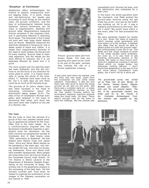
'Geophys' at <strong>Colchester</strong><br />
Geophysics offers archaeologists the<br />
chance to explore underground without<br />
digging holes. It is quick, cheap<br />
and non-destructive, but results vary<br />
according to such things as the method<br />
used, the ground conditions, and the<br />
type of archaeological features being<br />
explored. Various techniques can be<br />
used; ie magnetometry, resistivity and<br />
ground radar. Magnetometry measures<br />
minute variations in the magnetic field,<br />
and is particularly effective in detecting<br />
burnt areas. <strong>The</strong> downside is that it does<br />
not work well near large metal objects<br />
such as fences. Resistivity measures the<br />
electrical resistance in the ground, and is<br />
better suited to stone and rubble. It is<br />
slower than magnetometry because of<br />
the need to insert probes into the ground<br />
for every reading. Ground radar is relatively<br />
expensive, and the results are the<br />
most difficult to interpret, but it is not<br />
adversely affected by metal and it is<br />
quick.<br />
<strong>The</strong> main project over the past few years<br />
has been Gosbecks, and this will continue<br />
to be the focus of our attention for<br />
some years to come. It is hoped eventually<br />
to survey the whole of the area.<br />
About 11 hectares have been done so<br />
far, but it is early days yet and there<br />
could be as much as 60 hectares to go.<br />
<strong>The</strong> grounds of St John's Abbey have<br />
also been surveyed in the hope of<br />
recovering information about the<br />
demolished abbey (pages 23-5). <strong>The</strong><br />
sites of four of <strong>Colchester</strong>'s Roman town<br />
gates were targeted in the hope of<br />
recovering their plans, and there has<br />
also been work near Copford on the site<br />
of a Roman villa.<br />
Picture: ground-radar plot from<br />
Queen Street. <strong>The</strong> lines are<br />
puzzling and seem too far north<br />
to be part of the gate; perhaps<br />
they indicate the site of a<br />
former pedestrian crossing.<br />
It was pitch dark when we started, and<br />
the town was very quiet, apart from<br />
the occasional car and some street<br />
cleaners. Fortunately, it was dry and<br />
there was little wind to blow the string<br />
around as we laid out the grids. But<br />
there was a problem early on - a street<br />
cleaner thoughtfully warned us that<br />
we had twenty minutes before his<br />
automated cleaning machine washed<br />
away the chalk lines. Oh dear! <strong>The</strong>re<br />
wasn't enough time for the team to<br />
take the readings. But the cleaner was<br />
sympathetic and 'phoned his boss, and<br />
the obliteration was scheduled for a<br />
later time.<br />
In the event, the whole operation went<br />
like clockwork, and Peter pushed the<br />
ground-radar machine along the last<br />
chalk line at ten, and just as the traffic<br />
was building up. All in all, it was a<br />
masterly performance by the team. But<br />
did it work? We would know within a<br />
few hours, after Tim had processed the<br />
data.<br />
We were extremely hopeful for results<br />
of a sort. Given the mass of masonry<br />
which survives under pavements and<br />
how close it is to the surface, it seemed<br />
very likely that we would be able to<br />
detect some of it with the ground radar.<br />
But unfortunately it was not to be. <strong>The</strong><br />
kerbs and the rough surfaces of some<br />
of the roads caused some problems,<br />
but even so, it is very hard to see<br />
anything particularly positive in the<br />
results. We seem to have found evidence<br />
of a pedestrian crossing in Queen<br />
Street which no longer exists, but<br />
otherwise nothing definite. I don't<br />
doubt that geophysics is the way to find<br />
out more about <strong>Colchester</strong>'s town<br />
gates, but it won't be for a while yet.<br />
<strong>The</strong> ground-radar survey was carried<br />
out by Peter Cott, Dr John Woods, Dr<br />
Tim Dennis, Howard Brooks, Stephen<br />
Benfield and myself (Stephen, Peter,<br />
John and Tim are pictured below). <strong>The</strong><br />
hire of the ground-radar machine was<br />
kindly paid for by the Friends of<br />
the <strong>Colchester</strong> <strong>Archaeological</strong> <strong>Trust</strong>.<br />
<strong>The</strong> machine was supplied by Utsi<br />
Electronics.<br />
PC<br />
<strong>The</strong> team<br />
We are lucky to have the services of a<br />
group of four very capable people working<br />
on geophysical projects for the <strong>Trust</strong>.<br />
Peter Cott is the team leader. He is<br />
a communications engineer who has<br />
developed considerable expertise in geophysics<br />
since his retirement. He has<br />
been carrying out geophysical surveys at<br />
<strong>Colchester</strong> and in East Anglia since<br />
1993, particularly at Gosbecks. His first<br />
helpers were Dennis Tripp and James<br />
Fawn. Aline and David Black started as<br />
his assistants a few years ago, and having<br />
caught the bug, now carry out surveying<br />
themselves. Aline and David both<br />
have scientific backgrounds. Many people<br />
will know Aline from her time as Head at<br />
the <strong>Colchester</strong> County High School. Dr<br />
Tim Dennis is Senior Lecturer in the<br />
Department of Electronic Systems Engineering<br />
at the University of Essex. His<br />
primary role in the geophysics projects is<br />
the processing of the field data. He first<br />
became involved with <strong>Trust</strong> when he<br />
helped to organise the publication of live<br />
images of the Stanway excavation on<br />
the internet in 1997.<br />
22