The Colchester Archaeologist 2002 - Colchester Archaeological Trust
The Colchester Archaeologist 2002 - Colchester Archaeological Trust
The Colchester Archaeologist 2002 - Colchester Archaeological Trust

Create successful ePaper yourself
Turn your PDF publications into a flip-book with our unique Google optimized e-Paper software.
E St John's church,<br />
demolished 1095;<br />
excavated in 1972<br />
G Wall found<br />
in 1986<br />
12th-century<br />
precinct wall,<br />
masked here<br />
by modern<br />
buttresses<br />
Detail of Speed's map of <strong>Colchester</strong> published in<br />
I610.<br />
<strong>The</strong> Siege map of 1648 appears to show a gate<br />
flanked by two towers on the south side of the<br />
abbey. <strong>The</strong> exact location of the gate may be<br />
where a 19th-century path through the gardens<br />
crossed the line of the precinct wall. <strong>The</strong> path<br />
led southwards from the St John's Abbey gate,<br />
and it could conceivably have survived from the<br />
medieval period.<br />
Above: detail from the Siege map of 1648 showing<br />
the Royalist forces holding the former precinct of<br />
St John's Abbey. Whoever compiled the Siege map<br />
took Speed's map as its core and added in enough<br />
detail around the edges to show surrounding Parliamentarian<br />
siege works. <strong>The</strong> added material includes<br />
the apparent gate on the south side of the<br />
precinct, and what appears to be a more accurate<br />
drawing of the east end of the abbey church.<br />
continued on<br />
pages 26-27<br />
Left: St John's Abbey<br />
church. Compare with<br />
the apparent remains of<br />
the abbey church shown<br />
in the 1610 and 1648<br />
maps above.<br />
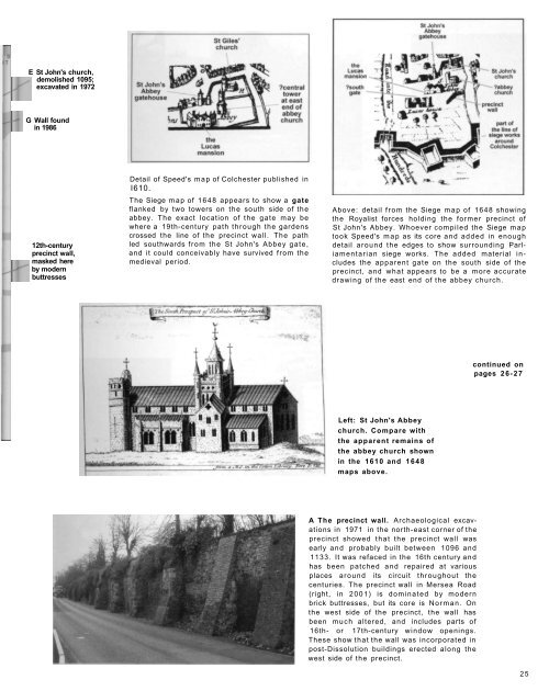
A <strong>The</strong> precinct wall. <strong>Archaeological</strong> excavations<br />
in 1971 in the north-east corner of the<br />
precinct showed that the precinct wall was<br />
early and probably built between 1096 and<br />
1133. It was refaced in the 16th century and<br />
has been patched and repaired at various<br />
places around its circuit throughout the<br />
centuries. <strong>The</strong> precinct wall in Mersea Road<br />
(right, in 2001) is dominated by modern<br />
brick buttresses, but its core is Norman. On<br />
the west side of the precinct, the wall has<br />
been much altered, and includes parts of<br />
16th- or 17th-century window openings.<br />
<strong>The</strong>se show that the wall was incorporated in<br />
post-Dissolution buildings erected along the<br />
west side of the precinct.<br />
25