RAYTHEON BRINGS EO TECHNOLOGY To Defend Our Nation
RAYTHEON BRINGS EO TECHNOLOGY To Defend Our Nation
RAYTHEON BRINGS EO TECHNOLOGY To Defend Our Nation

You also want an ePaper? Increase the reach of your titles
YUMPU automatically turns print PDFs into web optimized ePapers that Google loves.
FLIR SYSTEMS<br />
Continued from page 5<br />
MODIS sea-surface temperatures are<br />
required to model air-sea temperature interactions<br />
that affect climate and weather and<br />
correct radar tracking of incoming missiles<br />
threatening our ships at sea. Its estimates of<br />
aerosol levels and cloud cover contribute to<br />
global weather and climate prediction. Its<br />
vegetation assessments support global and<br />
seasonal crop forecasting. Its dust storm<br />
warnings support tactical military operations.<br />
The spectral capability of MODIS is the key<br />
to its ability to detect dust storms and provide<br />
key reports to military planners regarding<br />
the density, position, size, trajectory<br />
and visibility of these sand blizzards. Special<br />
spectral channels in the visible, nearinfrared<br />
and even longer wavelengths in<br />
the infrared, sensitive to temperature, allow<br />
MODIS to segregate land, ocean, clouds<br />
and dust in the same picture.<br />
MODIS has proven to be not only a successful<br />
tool to support scientific environmental<br />
studies — the basic mission for which it<br />
was originally designed — but also a necessary<br />
adjunct to civil weather forecasting and<br />
military operations worldwide (see Figure 1<br />
on page 5). In OEF and OIF conflicts that<br />
continue to make headlines, desert dust<br />
storms are the bane of infantry and airmen.<br />
MODIS is a key combat ally as well as an<br />
essential tool for continued NASA environmental<br />
research.<br />
Global Hawk Integrated Sensor<br />
Suite and Ground Segment<br />
With its unmatched sensor technology and<br />
sophisticated ground support systems, the<br />
Global Hawk unmanned aerial vehicle (UAV)<br />
offers a dramatic warfighting advantage.<br />
Raytheon developed the electronic sensors,<br />
radar and ground-based elements that<br />
allow Global Hawk to excel at providing<br />
critical ISR data to military field commands.<br />
Day or night, on land or at sea, and in all<br />
kinds of weather, the Raytheon Integrated<br />
Sensor Suite (ISS) on the air vehicle (Figure 2)<br />
pinpoints stationary or moving targets with<br />
unparalleled accuracy. It transmits imagery<br />
and position information instantaneously from<br />
65,000 feet with dramatic clarity, empowering<br />
warfighters to respond quickly and decisively.<br />
6 2005 ISSUE 1<br />
The Raytheon-built ISS enables Global<br />
Hawk to scan large geographic areas and<br />
produce outstanding high-resolution reconnaissance<br />
imagery. In just 24 hours, Global<br />
Hawk’s wide-area search mode can cover<br />
40,000-square nautical miles with 1-meter<br />
resolution; while in spot target mode, the<br />
sensors can search 1,900 2 km x 2 km<br />
spots with 0.33-meter resolution.<br />
<strong>To</strong> provide Global Hawk with its broad sensing,<br />
night vision and radar-detection capabilities,<br />
ISS combines a cloud-penetrating<br />
synthetic aperture radar antenna with a<br />
ground moving target indicator, a high-resolution<br />
<strong>EO</strong> digital camera and an IR sensor.<br />
A common signal processor, acting as an<br />
airborne supercomputer, ensures that all<br />
elements work together.<br />
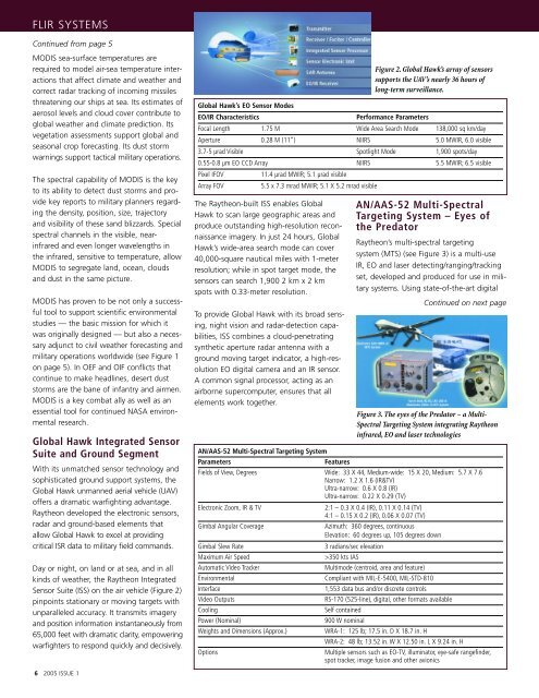
Figure 2. Global Hawk’s array of sensors<br />
supports the UAV’s nearly 36 hours of<br />
long-term surveillance.<br />
Global Hawk’s <strong>EO</strong> Sensor Modes<br />
<strong>EO</strong>/IR Characteristics Performance Parameters<br />
Focal Length 1.75 M Wide Area Search Mode 138,000 sq km/day<br />
Aperture 0.28 M (11”) NIIRS 5.0 MWIR, 6.0 visible<br />
3.7-5 µrad Visible Spotlight Mode 1,900 spots/day<br />
0.55-0.8 µm <strong>EO</strong> CCD Array NIIRS 5.5 MWIR; 6.5 visible<br />
Pixel IFOV 11.4 µrad MWIR; 5.1 µrad visible<br />
Array FOV 5.5 x 7.3 mrad MWIR; 5.1 X 5.2 mrad visible<br />
AN/AAS-52 Multi-Spectral Targeting System<br />
Parameters Features<br />
AN/AAS-52 Multi-Spectral<br />
Targeting System – Eyes of<br />
the Predator<br />
Raytheon’s multi-spectral targeting<br />
system (MTS) (see Figure 3) is a multi-use<br />
IR, <strong>EO</strong> and laser detecting/ranging/tracking<br />
set, developed and produced for use in military<br />
systems. Using state-of-the-art digital<br />
Continued on next page<br />
Figure 3. The eyes of the Predator – a Multi-<br />
Spectral Targeting System integrating Raytheon<br />
infrared, <strong>EO</strong> and laser technologies<br />
Fields of View, Degrees Wide: 33 X 44, Medium-wide: 15 X 20, Medium: 5.7 X 7.6<br />
Narrow: 1.2 X 1.6 (IR&TV)<br />
Ultra-narrow: 0.6 X 0.8 (IR)<br />
Ultra-narrow: 0.22 X 0.29 (TV)<br />
Electronic Zoom, IR & TV 2:1 – 0.3 X 0.4 (IR), 0.11 X 0.14 (TV)<br />
4:1 – 0.15 X 0.2 (IR), 0.06 X 0.07 (TV)<br />
Gimbal Angular Coverage Azimuth: 360 degrees, continuous<br />
Elevation: 60 degrees up, 105 degrees down<br />
Gimbal Slew Rate 3 radians/sec elevation<br />
Maximum Air Speed >350 kts IAS<br />
Automatic Video Tracker Multimode (centroid, area and feature)<br />
Environmental Compliant with MIL-E-5400, MIL-STD-810<br />
Interface 1,553 data bus and/or discrete controls<br />
Video Outputs RS-170 (525-line), digital, other formats available<br />
Cooling Self contained<br />
Power (Nominal) 900 W nominal<br />
Weights and Dimensions (Approx.) WRA-1: 125 lb; 17.5 in. D X 18.7 in. H<br />
WRA-2: 48 lb; 13.52 in. W X 12.50 in. L X 9.24 in. H<br />
Options Multiple sensors such as <strong>EO</strong>-TV, illuminator, eye-safe rangefinder,<br />
spot tracker, image fusion and other avionics