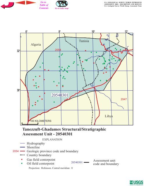
<strong>USGS</strong> PROVINCE: Trias/<strong>Ghadames</strong> Basin (2054)GEOLOGIST: T.R. KlettTOTAL PETROLEUM SYSTEM: <strong>Tanezzuft</strong>-<strong>Ghadames</strong> (205403)ASSESSMENT UNIT: <strong>Tanezzuft</strong>-<strong>Ghadames</strong> Structural/Stratigraphic (20540301)DESCRIPTION: This total petroleum system and corresponding assessment unit coincide with the<strong>Ghadames</strong> (Berkine) Basin, bounded on the north by the Talemzane-Gefara Arch, on the east by theHamra Basin, on the south by the Illizi Basin, and on the west by the Amguid-Hassi Touareg structuralaxis.SOURCE ROCKS: The major source rocks are the Silurian <strong>Tanezzuft</strong> Formation and Middle toUpper Devonian mudstone. Frasnian-aged mudstone is the richest among Devonian source rocks.MATURATION: Petroleum generation from Silurian source rocks started as early as theCarboniferous, was interrupted by the Hercynian event, and then peaked from the Late Jurassic to themiddle Cretaceous. Generation from Middle to Upper Devonian source rocks started as early as theLate Triassic and peaked from the Early Cretaceous to the early Tertiary.MIGRATION: Petroleum migrated laterally into adjacent or juxtaposed reservoirs and verticallyalong faults or fractures.RESERVOIR ROCKS: Known reservoir rocks include Cambrian-Ordovician fluvial to marinesandstone, Ordovician to Silurian paralic and marine sandstone, Upper Silurian nearshore to marinesandstone, Devonian and Carboniferous deltaic to marine sandstone, and Triassic fluvial sandstone.TRAPS AND SEALS: Most of the known accumulations are within anticlines, faulted anticlines, orfault blocks. Some combination traps are present. Triassic to Jurassic evaporites, mudstone, andcarbonate rocks provide a regional top seal. Intraformational Paleozoic marine mudstone provides theprimary seal for some reservoirs.REFERENCES:Boote, D.R.D., Clark-Lowes, D.D., and Traut, M.W., 1998, Palaeozoic petroleum systems ofNorth Africa, in Macgregor, D. S., Moody, R.T.J., and Clark-Lowes, D.D., eds.,Petroleum geology of North Africa: London, Geological Society, Special Publication No. 132,p. 7-68.Boudjema, A., 1987, Evolution structurale du bassin petrolier «Triasique» du Sahara Nord Oriental(Algerie): Thèse a l'Universite de Paris-Sud, Centre d'Orsay, 290 p.Daniels, R. P., and Emme, J. J., 1995, Petroleum system model, easteren Algeria, from source rock toaccumulation: when, where, and how? Proceedings of the Seminar on Source Rocks andHydrocarbon Habitat in Tunisia: Entreprise Tunisienne d'Activites Petrolieres Memoir 9, p.101-124.
6 8 10 1232Algeria2054Tunisia30205403012047100 KILOMETERSLibya2054<strong>Tanezzuft</strong>-<strong>Ghadames</strong> Structural/StratigraphicAssessment Unit - 20540301EXPLANATIONHydrographyShorelineGeologic province code and boundaryCountry boundaryGas field centerpointOil field centerpointProjection: Robinson. Central meridian: 020540301Assessment unitcode and boundary