Staplecross Welly Walk Leaflet - Walk4Life
Staplecross Welly Walk Leaflet - Walk4Life
Staplecross Welly Walk Leaflet - Walk4Life

You also want an ePaper? Increase the reach of your titles
YUMPU automatically turns print PDFs into web optimized ePapers that Google loves.
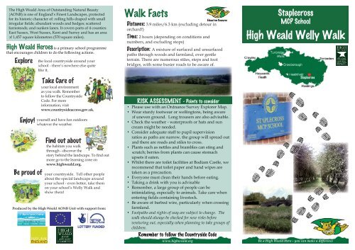
for its historic character of: rolling hills draped with smallfarmsteads; and sunken lanes. It covers parts of 4 counties:of 1,457 square kilometres (570 square miles).High Weald Heroes is a primary school programmethat encourages children to do the following actions.ExploreEnjoy!Be proud ofthe local countryside around yourschool - there’s nowhere else quitelike it.Take Care ofyour local environmentas you walk. Rememberto follow the CountrysideCode. For moreinformation, visitwww.countrysideaccess.gov.uk.yourself and have fun outdoorswhatever the weather.Find out aboutthe habitats you walkthrough - discover themore go to the learning zone onwww.highweald.org.your countryside. Tell other peopleabout the special landscape aroundyour school - even better, take themon your school’s <strong>Welly</strong> <strong>Walk</strong> andshow them!Produced by the High Weald AONB Unit with support from:<strong>Walk</strong> FactsDistance:orchard!)Time: 2 hours (depending on conditions andDescription: paths through woods and farmland, over gentleterrain. There are numerous stiles, steps and footbridges, with some busier roads to be aware of.RISK ASSESSMENT - Points to consider of uneven ground. Long trousers are also advisable. cream might be needed. ratios as paths are narrow, the group will spread outand there are roads and stiles to cross. scratch; berries from plants can cause stomachupsets if eaten. recommend that toilet paper and hand wipes aretaken as a precaution. intimidating, especially to animals. Take care when farmland. Footpaths and rights of way are subject to change. Thewalk should always be checked for new risks beforeventuring out, especially when planning to take groups ofchildren.Remember to follow the Countryside Codewww.highweald.org<strong>Staplecross</strong>MCP SchoolHigh Weald <strong>Welly</strong> <strong>Walk</strong><strong>Staplecross</strong>Be a High Weald Hero - you can make a difference
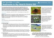
123456789101112For guidance only; actual conditions may be different from those shown, depending on the weather and time of year.Photo guide and route descriptionHollow Wall Farm, on your left. Immediately after the farm, go through a wooden gate, 1 following the narrow public footpath downhill. At the small pond, bear right. Crossthe farm track and head up the grassy bank, following the public footpath arrows. You are now walking with a large hedgerow to your right and stunning views of the High2then down the gentle hill towards the wooden huts near the trees. Just past the last hut, turn left towards an orchard. When you get to the orchard, turn right to walk towards a3
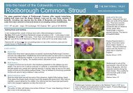
Ancient WoodlandTrees and woodland cover over one-third of the High Wealdand are a key landscape feature.The woods of the High Weald were relatively slow to becleared because they were a valuable resource: providingtimber for building, fuel for heating and charcoal for ironsmelting, as well as animal feed - acorns and beech mastHigh Weald, much woodland was retained and continued toprovide valuable resources, particulary for the iron industry.Today, 70% of the HighWeald’s woodlands areclassed as ancient - havinghave been maintained forcenturies by skilled workersusing a rotational coppicesystem.Coppicing is when trees arecut down low to the groundin such a way that the stemsgrow back afterwards. Thetrees are cut once every 10 -15 years. The harvested woodis used to make products such as fencing stakes, charcoal,hurdles and trugs. When the trees are coppiced, the light canreach right down to the ground as the branches and leaves aregrow including bluebells, wood anemones and wild garlic.These plants attract insects to feed on the nectar, and birds andare now only found in working coppice.Woodlands have been managed in this way for hundredsof years and it is important for the plants and the wildlifewood products helps to ensure the continuation of traditionalmanagement.The Story of the High Weald’s Fieldsis its pattern of small, irregularsettlers began moving into the HighWeald in increasing numbers. Theseearly farmers began clearing thesurrounding woods and scrub to makeclearances were done in an unplannedway by the individual farmers. This isin shape.A Medieval Landscapemuch the same as it does today. The landscape of the HighWeald is essentially medieval: this can be said of few otherplaces in the country.With their heavy clay soils and steep slopes, many High Wealdtraditionally been used for rearing cattle and sheep.rich hay meadows and pastures. These ‘unimproved’grasslands are some of our most important habitats forconservation.woodland along their edges?Ancient Routewaysthe woods each year to fatten them on acorns and beech mast.This happened during thelate summer and earlyautumn; the farmerswould have builttemporary shelters to keepwarm while watching theirpigs. These woodland pigpastures were called dens.Weald have namesending in den - forfrequent passage of pigs being driven to and fro between theirparent villages (often 20 miles away) created drove roads. TheHigh Weald’s unique landscape.OrchardsThis walk passes through some beautiful High Weald orchards- including organic and traditionally managed sites that aremaintained by hand, rather than machines. The history ofpatterns of orchards contrastwith the smooth sweeps ofpastures, shaws and woods.orchards offer a variety ofwildlife habitats all yearround. In spring,blossom provides a sourceof pollen for bees andmoths; in summer the leafycanopy is a perfect nestingsite for many birds, including woodpeckers,a good food source for foraging creatures such as badgers andhedgehogs.currants, gooseberries, strawberries, raspberries and other fruitcan also be found growing in the area.orchard and the managed orchards?Gill StreamsIn the organic orchard, near the end ofthis walk, pause a moment to admire theroute carved out by an ancient gill stream.High Weald lie bands of sandstone and clay.carved by rivers, these materials give theHigh Weald its shape. The clay is soft andeasily worn away: it forms the low valleys ofthe High Weald, with the harder sandstonewooded gills are a special feature of the High Weald: they areformed where a stream has carved a deep channel for itselfinto rivers that have formed wide valleys in the eastern part ofthe High Weald, before reaching the sea.