Surface Water Management Plan - Hampshire County Council
Surface Water Management Plan - Hampshire County Council
Surface Water Management Plan - Hampshire County Council

You also want an ePaper? Increase the reach of your titles
YUMPU automatically turns print PDFs into web optimized ePapers that Google loves.
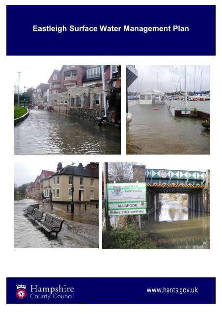
Eastleigh <strong>Surface</strong> <strong>Water</strong> <strong>Management</strong> <strong>Plan</strong>January 2012www.hants.gov.uk
Document Control InformationDocument InformationDocument Reference501752/SWMPEBC/01Document Revision -Report StatusDRAFT – For consultationDate DEC 12AuthorS ReghifCheckerP ErringtonApproverDate of Next Review<strong>Hampshire</strong> <strong>County</strong> <strong>Council</strong>Economy, Transport and Environment DepartmentThe CastleWinchester<strong>Hampshire</strong>SO23 8UDTel: 0845 603 5638 Fax: 01962 847055www.hants.gov.ukThis report was produced by <strong>Hampshire</strong> <strong>County</strong> <strong>Council</strong> in accordance with the Defra<strong>Surface</strong> <strong>Water</strong> <strong>Management</strong> <strong>Plan</strong> Technical Guidance document dated March 2010.No part of this document may be copied or reproduced by any means without priorwritten permission from HCC.Any advice, opinions or recommendations within this document;a) should be read and relied upon only in the context of this document as awhole,b) do not in any way purport to include any manner of legal advice or opinion,c) are based on the information made available to HCC at the date of thisdocument and on current UK standards, codes, technology and constructionpractises as at the date of this document.No liability is accepted for any use of this document other than for the purpose forwhich it was originally prepared and provided. <strong>Hampshire</strong> <strong>County</strong> <strong>Council</strong> cannotaccept responsibility for any use or reliance on the contents from this report by anythird party.Maps are reproduced from Ordnance Survey material with the permission ofOrdnance Survey on behalf of the Controller of Her Majesty’s Stationery Office ©Crown Copyright. Unauthorised reproduction infringes Crown copyright and may leadto prosecution or civil proceedings. HCC 100019180 [2011].
<strong>Hampshire</strong> <strong>Surface</strong> <strong>Water</strong> <strong>Management</strong> <strong>Plan</strong>s (SWMP)- EastleighExecutive SummaryThis is one of a suite of <strong>Surface</strong> <strong>Water</strong> <strong>Management</strong> <strong>Plan</strong>s being prepared fordistricts in <strong>Hampshire</strong>. By 2015 it is anticipated that there will be full coverageof all <strong>Hampshire</strong> districts with SWMPs.The document has been prepared by <strong>Hampshire</strong> <strong>County</strong> <strong>Council</strong> inconjunction with stakeholder and partner organisations through a stakeholderofficer group comprising representatives from the relevant district council andadjoining authorities, the Environment Agency and the water companies.The document focuses on surface water flood risk in Eastleigh borough. Itshould be read alongside the Strategic Overview and Background InformationSWMP document which provides a context for this report and the others to beprepared in future.The document describes the topography, geology and hydrology of Eastleighborough and describes other significant features which can impact on surfacewater flood risk. It collates and assesses historic data on surface water floodevents in Eastleigh and uses Defra / Environment Agency mapping data andprojections to determine likely future flood risk taking into account the impactsof climate change.This data is described and assessed by Parish (including the un-parishedarea of Eastleigh town itself) looking at each area’s susceptibility to floodingbased on information from past flood events and the likelihood of futureflooding based on national modelling data.This allows a hierarchy of flood risk in the borough to be identified along withsurface water flooding ‘hotspots’ where further, more detailed work may berequired into the causes of, and possible responses to, flood risk. It highlightswhat solutions may be required to address and/or mitigate flood risk in those‘hotspot’ areas and where further investigation is recommended.Flood risk management responses are proposed which cover a range of areasincluding effective communication, policy responses and physical works.Ultimately the aim of identifying hotspots is to bring these areas to theattention of all parties who may be able to influence and reduce flood risk.This SWMP report will continue to evolve as flood risk is better understoodand as additional flood risk areas are identified, ultimately leading to areduction in the risk of flooding as well as an increase in the understanding offlood risk across the borough.
Contents1. Introduction...............................................................................................12. Background...............................................................................................13. Aims & Objectives.....................................................................................34. The Study Area.........................................................................................34.1. General..............................................................................................34.2. Geology and Soils..............................................................................44.3. Hydrology ..........................................................................................55. Establishing Partnerships .........................................................................66. Locally Agreed <strong>Surface</strong> <strong>Water</strong> Flooding Information.................................76.1. Existing and Historic Flooding Incidents ............................................86.2. Future / Potential <strong>Surface</strong> <strong>Water</strong> Flood Risk......................................97. Risk Assessment ....................................................................................107.1. Intermediate Level Assessment.......................................................107.2. Parish Risk Assessment ..................................................................117.2.1. Allbrook ....................................................................................137.2.2. Bishopstoke..............................................................................147.2.3. Botley .......................................................................................157.2.4. Bursledon .................................................................................167.2.5. Chandlers Ford.........................................................................177.2.6. Eastleigh Town.........................................................................187.2.7. Fair Oak and Horton Heath.......................................................197.2.8. Hamble-le-Rice.........................................................................207.2.9. Hedge End................................................................................217.2.10. Hound ...................................................................................227.2.11. West End ..............................................................................237.3. Flooding Hotspots Requiring Further Assessment...........................247.4. Managing the Potential for Flood Risk.............................................267.5. Managing Flood Risk.......................................................................268. Evaluation of Options & Considerations..................................................289. Implementation and Recommendations..................................................2910. Review & Monitoring ...........................................................................3111. Conclusion ..........................................................................................3212. Abbreviations ......................................................................................3313. Glossary..............................................................................................34Figure 1: Eastleigh Location <strong>Plan</strong> ....................................................................4Figure 2: Location of Parishes within Eastleigh Borough...............................12Figure 3: Location of Sites Recommended for Further Assessment ..............25Table 1: Flooding Hotspots Requiring Further Assessment...........................24Table 2: Properties potentially at risk from surface water flooding.................26Table 3: Example of Short-Listing Criteria (taken from Defra TechnicalGuidance) ......................................................................................................29APPENDIX A – Data sharing protocol and data assessmentAPPENDIX B – Borough Level MapsAPPENDIX C – Flood Database and risk assessmentAPPENDIX D – Area Level MapsAPPENDIX E – Action <strong>Plan</strong>
<strong>Hampshire</strong> <strong>Surface</strong> <strong>Water</strong> <strong>Management</strong> <strong>Plan</strong>s (SWMP)Eastleigh1. IntroductionThis document is one of a suite of intermediate level <strong>Surface</strong> <strong>Water</strong><strong>Management</strong> <strong>Plan</strong>s (SWMPs) being prepared for individual districts in<strong>Hampshire</strong>. It should be read alongside the <strong>Surface</strong> <strong>Water</strong> <strong>Management</strong> <strong>Plan</strong>Strategic Assessment and Background Information document which providesgeneric background and supporting information relevant to each of the districtSWMPs.The overall aim of this SWMP study is to ensure that all flood risk partnerswork together to understand the locations, causes and effects of floodingwithin the borough of Eastleigh and to identify measures to mitigate againstflooding in the form of an Action <strong>Plan</strong> (see Appendix E). Once in place, thisAction <strong>Plan</strong> should be reviewed and updated on a regular basis, inaccordance with Defra guidance.The scope of this report is to expand on the strategic assessment carried outunder the Flood Risk Regulations, in the form of the Preliminary Flood RiskAssessment and to carry out an intermediate assessment, within Eastleigh.2. BackgroundIn 2009, Defra produced a National Rank Order of Settlements Susceptible to<strong>Surface</strong> <strong>Water</strong> Flooding, ranked by the estimated number of propertiessusceptible to surface water flooding resulting from severe rainfall. This rankorder was populated using a new national methodology indicating the relativeeffect between settlements if each was subjected to a similar severe rainfallevent.This ranked list of settlements was developed using the EnvironmentAgency’s Areas Susceptible to <strong>Surface</strong> <strong>Water</strong> Flooding maps. These mapsindicate areas considered to be susceptible to flooding from surface water,categorised within three bandings; less, intermediate and more susceptible.The Areas Susceptible to <strong>Surface</strong> <strong>Water</strong> Flooding map was produced using asimplified modelling technique that assumes underground sewerage anddrainage systems, and smaller over ground drainage systems are full tocapacity so preventing surface water draining from the surface. The impactsof buildings are not considered. This method uses a single rainfall event with a1 in 200 chance of occurring in any year.Priority locations within <strong>Hampshire</strong> were identified by Defra where evidenceindicating the risk and potential impact of surface water flooding could behighest and where SWMPs would be most effective to understand andmanage flooding. Using this assessment, as well as historic floodinginformation, Defra identified a need for SWMPs to be produced for three1
areas: - Rushmoor, Basingstoke and the central <strong>Hampshire</strong> chalk catchment(groundwater flooding).In addition to this, Eastleigh, ranked just outside of the initial funded SWMPsat no. 102, was also deemed to require a SWMP. This SWMP will initiallyconsider the risk of flooding across the entirety of the borough of Eastleigh toenable better understanding of the flood risk in this area and to assesspotential mitigation options for areas determined to be at a high risk offlooding.The first stage of any SWMP is data collection, involving consultation with keypartners and stakeholders to obtain all relevant data and information relatingto historic and current flooding, alongside information on flood receptors andflood consequences.Following completion of the data collection phase, the surface water floodinginformation is assessed in order to identify ‘hotspot’ areas that have a historyof flooding incidents. These are prioritised for further investigation initially.However, sites considered being at a potential future risk of flooding will alsobe considered and the information used to inform the planning process andthe future location of new development.It should be borne in mind, however, that this is one in a series of intermediateSWMPs planned across the county. Areas identified as a priority in Eastleighwill, in due course, need to be considered alongside priority areas identified infuture SWMPs covering other districts. Similarly, the order in which potentialflood alleviation / mitigation schemes are identified and progressed will beconsidered in this broader context rather than on a district by district basis.Another determinant of which, how and when schemes are progressed will bethe availability of funding to implement such works.Flooding arising from a combination of sources, and flooding incidentsinvolving interaction between different flood types, will fall to the Lead LocalFlood Authority (<strong>Hampshire</strong> <strong>County</strong> <strong>Council</strong>) to investigate, and thereforethese types of flood incident will be considered within the scope of thisSWMP.This report aims to consider all hydraulic flooding incidents in Eastleigh butdoes not address sewer flooding where it occurs as a result of operationalissues as this is the responsibility of the water companies.It should also be noted that the compilation of flooding events within theborough does include some flooding solely due to main rivers, responsibilityfor which falls to the riparian landowner and is under the supervision of theEnvironment Agency. Therefore, further investigation of these occurrences isconsidered to be outside the remit of this report. Coastal flooding is alsobeyond the scope of this report and falls within the remit of the EnvironmentAgency and, by agreement, District, Borough and City councils.2
3. Aims & ObjectivesWithin the overarching SWMP document, a number of generic objectives havebeen developed which should be considered as the basis for any SWMP.These objectives are to: Map historic flood incident data; Map flooding locations influenced by surface water; Identify surface water flooding ‘hotspot’ areas; Assess, compare and prioritise ‘hotspot’ areas for detailedassessment; Identify measures where appropriate, assess options and confirmpreferred mitigation options for identified ‘hotspots’; Engage with partners and stakeholders; and Make recommendations for the next stages of assessment.In addition to these, specific objectives for the Eastleigh SWMP are as follows:To identify and record known drainage assets in high risk areas,including information on condition, ownership and maintenancerequirements; andTo ensure the results of the SWMP link into both developmentplanning and emergency planning policies and procedures.This report will also refer to, and take into account, information andrecommendations made within the following key documents:Partnership for Urban South <strong>Hampshire</strong> (PUSH) Strategic Flood RiskAssessment produced by Halcrow,Test & Itchen Catchment Flood <strong>Management</strong> <strong>Plan</strong>, published by theEnvironment Agency.South East Catchment Flood <strong>Management</strong> <strong>Plan</strong>, published by theEnvironment AgencyRiver Basin <strong>Management</strong> <strong>Plan</strong>: South East River Basin District;North Solent Shoreline <strong>Management</strong> <strong>Plan</strong>, Selsey Bill to Hurst Spit4. The Study Area4.1. GeneralEastleigh Borough lies in the central south of <strong>Hampshire</strong> and includes thetown of Eastleigh and a number of smaller settlements.The borough covers an area of over 8,000 hectares, containing a mixture ofhighly urbanised settlements with more sparsely populated agricultural landin-between, supporting a population of approximately 116,000 living in around50,000 dwellings.3
The Rivers Itchen and Hamble run through Eastleigh Borough. They are chalkrivers of international importance as evident in the number of environmentaldesignations along their length. They provide a habitat for a number of rareplant and animal species as well as being important sources of fresh water forsouthern <strong>Hampshire</strong>.To the south of Eastleigh Borough is The Solent, an internationally importantstretch of coastline with an extremely busy shipping area. The twin tides alongthis section of coastline give rise to important habitats at the mouth of theItchen and Hamble including large areas of marshland which are recognisedfor their environmental importance.A number of contextual maps are provided in Appendix B to illustrate theenvironmental and historical areas of importance within the borough as wellas other related information.Figure 1: Eastleigh Location <strong>Plan</strong>4.2. Geology and SoilsThe geology of an area has a significant impact on its ability to contain anddrain surface water and other water flows. The borough of Eastleigh lies withinthe eastern part of the <strong>Hampshire</strong> Basin geological region, a broad basin filledwith bedrock Tertiary clays and sands which overlay Cretaceous Chalk atdepth. The centre of the borough is divided by a north-westerly continuation ofthe Portsdown Anticline, featuring the anticline and a complimentary syncline.For this reason the bedrock Thames Group London Clay Formation outcropsboth in the north and the centre of the area, whilst the bedrock BrackleshamGroup Formations are found in the centre and south of the borough.4
The superficial deposits have been influenced by Southampton <strong>Water</strong> to thesouth-west and several significant watercourses flowing towards the sea,particularly the Monks Brook, Barton River/Lower Itchen and the RiverHamble. Accordingly the flanks of Southampton <strong>Water</strong> feature a succession ofRiver Terrace Deposits (from the second to ninth terraces) whilst the rivervalleys feature both Alluvium and River Terrace Deposits. Immediatelyadjacent to Southampton <strong>Water</strong> lie superficial Tidal Flat Deposits. The LowerItchen and River Hamble rise on Chalk outcrops outside the borough with theChalk providing continual flow to both throughout the year. The lower reachesof the River Hamble are tidal.The sandier members of the London Clay Formation and Bracklesham Groupare secondary or minor aquifers capable of supporting water supplies at alocal rather than strategic level and in some cases forming an important baseflow to rivers, whilst the clays are unproductive or non aquifers. The sandyand gravelly elements of the superficial River Terrace Deposits also functionas secondary or minor aquifers. Such aquifers can display a wide range ofwater permeability and storage. As such, infiltration drainage is only likely tobe possible where sands or gravels are present and as variable clay contentproduces variable permeability and high groundwater levels, then groundinvestigation is a necessity for effective design and to reduce flood risk.Mapping illustrating the geology of Eastleigh Borough is included withinAppendix B.4.3. HydrologyThe borough of Eastleigh is dominated by two main river catchments; theRiver Itchen catchment covers the majority of the borough with the RiverHamble catchment to the East.Within the River Itchen catchment there are seven sub catchments affectingEastleigh which link into the different rivers. These areas are illustrated on themaps in Appendix B and highlight the area in which run off could be controlledto influence the level of flooding at different points.The River Hamble catchment includes four sub catchments within theEastleigh boundary. The majority of these affect the southern part of theborough and are illustrated within Appendix B.The Itchen catchment is largely dominated by groundwater flow due thebedrock geology that underlies the area. The River Itchen is considered oneof the best chalk streams in the world with excellent diversity and qualitywaters, meaning it is covered by several designations including the SpecialArea of Conservation (SAC) and Sites of Special Scientific Interest (SSSI)designations.In contrast to the upper section of the river, the lower section flows throughheavily urbanised areas making the catchment very prone to flash floodingfrom surface water run off and drainage systems being overwhelmed. Flood5
isk is likely to increase in the future due to the prediction of more frequentintense storms.A major tributary that flows into the River Itchen, and forms a considerablepart of this catchment, is Monks Brook which runs through Chandlers Ford.Much of this watercourse has been culverted and, due to the proximity ofproperties and infrastructure, has the potential to cause significantconsequences if flooding occurs.The River Hamble catchment is predominantly rural in the upper section andhighly urbanised in the lower section leading to very different characteristics ineach.This catchment drains into a number of designated sites of national andinternational importance for nature conservation, such as the Solent andSouthampton Special Protection Area and Ramsar site or the Solent MaritimeSpecial Area of Conservation. The upper section runs over permeable chalkswhere there are few properties and a lower risk of surface water flooding,whereas the lower section is dominated by clay with the potential to causeflash flooding in the urbanised areas along the coast. Future developmentcould put added strain on existing drainage systems and will need to becarefully managed, particularly with the projected effects of climate change asidentified in the SWMP Strategic Assessment & Background Informationdocument.A plan indicating the river catchments and river network is included inAppendix B.5. Establishing PartnershipsThe Flood and <strong>Water</strong> <strong>Management</strong> Act 2010 requires that unitary and countyauthorities take the lead on local flood risk management activities and definesthem as a Lead Local Flood Authority (LLFA). The <strong>County</strong> <strong>Council</strong>, in its roleas LLFA, has a responsibility to lead and convene production of the SWMPensuring it is maintained and updated as required.In view of this, <strong>Hampshire</strong> <strong>County</strong> <strong>Council</strong> has taken the lead on this SWMPbringing together those stakeholders that are critical for its production as wellas providing information relating to its role as a <strong>Plan</strong>ning Authority, HighwayAuthority, Emergency <strong>Plan</strong>ning Authority and LLFA.As with all SWMPs, there are a number of key partners in addition to<strong>Hampshire</strong> <strong>County</strong> <strong>Council</strong> each with important roles to play in managingflood risk. In this case they are:Eastleigh Borough <strong>Council</strong>Environment Agency andSouthern <strong>Water</strong>Eastleigh Borough <strong>Council</strong> has a number of permissive powers under theLand Drainage Act 1991 for the prevention and mitigation of flood damage6
from ordinary watercourses and also responsibility for managing flood riskencompassed in planning legislation.Eastleigh falls within the Environment Agency’s South East region. TheEnvironment Agency has a supervisory role over all aspects relating to flooddefence with a more specific role to the maintenance of main rivers.The borough is served by Southern <strong>Water</strong> supplying foul and surface watersewerage systems. Southern <strong>Water</strong> is also responsible for the maintenance ofthese networks.A Data Sharing Protocol has been agreed and signed up to by these partnersin order to agree the terms by which data is shared throughout the process ofundertaking the Eastleigh SWMP and to ensure data is used correctly.Any decisions made by these partners could also have implications on howbodies and organisations carry out their roles with respect to drainage andflood risk management. In particular those listed below:Network Rail;Highways Agency;Flood risk is not contained within administrative boundaries. Therefore it isvital, in considering the management of surface water, to involve neighbouringauthorities. In this case this includes the following authorities:New Forest District <strong>Council</strong>;Test Valley Borough <strong>Council</strong>;Winchester City <strong>Council</strong>;Southampton City <strong>Council</strong>;All of the bodies and organisations highlighted above have been invited tocomment on this SWMP.6. Locally Agreed <strong>Surface</strong> <strong>Water</strong> Flooding InformationGiven the high volume of available data it is essential to establish the mostappropriate datasets, both in terms of quality and coverage, to enable asuitable assessment of local flood risk.As part of the preparation phase of this SWMP, all available flood related datawas collected from each partner and assessed in terms of quality andcoverage across the borough. This data contained a range of information onhistoric flooding incidents as well as theoretical information relating to thepotential for flood risk.Each piece of data was assessed in accordance with the data quality andconfidence criteria agreed between the partners. These criteria are:7
1 Best Possible - No better available; not possible to improve in the nearfuture2 Data with known deficiencies - Best replaced as soon as new data areavailable3 Gross assumptions - Based on experience and judgement4 Heroic assumptions - An educated guessEach dataset obtained for the use of this SWMP is listed within Appendix Atogether with its data quality score.Information must only be used in ways appropriate to the quality of data, scaleof mapping etc and each partner has specific conditions of use for dataoutside each individual organisation. These conditions must be complied withand no third party information will be distributed or reproduced without eitherthe express consent of that data owner or confirmation that the conditions foruse of the data is adhered to. When considering Freedom of Information (FoI)or Environmental Information Regulations (EIR) requests, <strong>Hampshire</strong> <strong>County</strong><strong>Council</strong> is unable to release information which is owned by a third party. Datalicensing requirements are identified within Appendix A alongside the dataquality scoring.6.1. Existing and Historic Flooding IncidentsData relating to historic flooding incidents was available from all keystakeholders and was generally assessed as being of good quality in terms offlood location although the extent and consequences of these incidents werenot as well recorded.Information on known flooding has been incorporated into a flood databaseincluding as much information as is known about each flood site. Thisdatabase has been ratified by the SWMP partners and it has been agreed thatthe localised flooding incidents database constitutes the best availableinformation on existing and historic flooding incidents. However this data mustnot be used to identify individual properties at risk of flooding or with basemapping of more than 1:25,000.This database includes sites which have experienced flooding as a result ofextreme weather conditions or rainfall which has exceeded the designcapacity of the existing drainage system as well as sites where blockages orfailures in the system has led to flooding.Historic flooding data can be subjective as often few formal records exist andmuch of the information comes from local knowledge gathered over a periodof time. The Borough <strong>Council</strong>, Environment Agency and water companieswere asked to comment on all historic flood data, corroborating the details aswell as providing additional local flood risk sites, to ensure that the data is asaccurate and up to date as possible allowing a high level of confidence to begiven to these records. It is a living dataset and will be expanded and updatedas new data is obtained.8
6.2. Future / Potential <strong>Surface</strong> <strong>Water</strong> Flood RiskThere are two key datasets available from the Environment Agency whichassess the potential for surface water flooding, namely the Areas Susceptibleto <strong>Surface</strong> <strong>Water</strong> Flooding and the Flood Map for <strong>Surface</strong> <strong>Water</strong>.The Areas Susceptible to <strong>Surface</strong> <strong>Water</strong> Flooding map was produced in July2009. It was produced using a simplistic modelling technique based on asingle rainfall event, namely a storm with a 1 in 200 chance of occurring in anyyear, highlighting areas that could be affected by surface water flooding withinthree different bandings; less, intermediate and more. It does not take intoaccount buildings, drainage or ground permeability. This map should not beused with base mapping of more than 1:50,000 and is not designed to be adetailed representation of areas that could flood.The Agency produced a more detailed Flood Map for <strong>Surface</strong> <strong>Water</strong>, issued inNovember 2010. This uses a more sophisticated modelling technique basedon a number of different assumptions for ground permeability, drainagecapacity and flow routing around structures. It was created using both a 1:30and 1:200 annual probability and separates the level of flood risk into areasthat could experience flooding in excess of 100mm and 300mm. It should notbe used with base mapping of more than 1:25,000 and is not designed toidentify individual properties at risk.Environment Agency guidance suggests that the Areas Susceptible to <strong>Surface</strong><strong>Water</strong> Flooding (2009) map would be more representative of flooding in areaswhere there is minimal drainage capacity and flat areas with a longer stormduration with the Flood Map for <strong>Surface</strong> <strong>Water</strong> (2010) being more suitable forother areas. However, the Environment Agency has stated that localinformation on flooding should be used to identify the most suitable mappingfor specific locations.Upon analysis of the available flood risk data, the SWMP partners haveagreed that the dataset providing the best representation of potential flood riskin Eastleigh is the 2010 Flood Map for <strong>Surface</strong> <strong>Water</strong>.The 1 in 30 year annual probability surface water flood mapping has beenchosen to assess flood risk as the majority of drainage infrastructure andproperty resilience measures are currently designed to accommodate thisscale of rainfall event. Sites at risk of flooding from 1 in 30 year rainfall eventor less will therefore be prioritised for investigatory work so that those areas atthe highest risk can be considered for future works.<strong>Surface</strong> water flooding arising from 1 in 200 year rainfall event is consideredvery extreme rainfall which exceeds that which is generally designed to becontained within drainage systems. However, it should be modelled in termsof exceedance so that overland flows do not cause property flooding and arerouted away from properties where feasible. This dataset is therefore of mostuse for land-use planning purposes.9
In addition to these datasets, there is also information available relating tocoastal and fluvial (river) flood risk. This data takes the form of the ‘FloodZones’ mapping and identifies areas at high, medium and low risk of thesetypes of flooding. This mapping is essential in order to identify where therecould be issues with the interaction of surface water and other types offlooding.Eastleigh Borough is included within the Strategic Flood Risk Assessmentcarried out by PUSH, the Partnership for Urban South <strong>Hampshire</strong>. This aimsto assess the risk of flooding across south <strong>Hampshire</strong> using information onknown and potential flood risk and assesses vulnerability, land use as well astopographical information. Where appropriate, this information will be used aspart of the assessment of potential flooding risk for Eastleigh as well as beingused to substantiate the findings of this SWMP.7. Risk Assessment7.1. Intermediate Level AssessmentIdentification of ‘Hotspots’Following the strategic assessment undertaken as part of the PFRA, sitesknown to have flooded previously have been identified and assessed. Fromthe information provided in flood incident reports it is clear that the extent,frequency and depth of flooding ranges widely, from very minimal surfacewater ponding to flooding at a depth that poses a high risk to people andproperty. There was a need to rank the individual sites and reduce the numberto focus on those that posed the highest risk. Once these sites, known as‘hotspots’, were identified, a more thorough risk assessment could beundertaken and the sites reviewed in order of their assessed risk.In order to rank the sites in terms of flood risk, a matrix scoring system wasdeveloped. This assesses probability and consequence of flooding at eachidentified site within the flood risk database. The matrix scoring apportions ascore to the flood risk criteria described in the Strategic Assessment andBackground Information report. The sites assessed within Eastleigh Boroughare listed in Appendix C.For the highest ranked sites or those where the cause or potential mitigation iscomplex, a more detailed assessment may be carried out with siteinvestigations to determine existing drainage, works carried out, potential riskand a more thorough assessment of the available data. This will allowpotential mitigation options to be reviewed and a cost benefit analysis to becarried out to determine the likelihood of securing funding for any potentialschemes. This assessment is more detailed than this intermediate SWMP andwill be carried out separately.10
However, for those sites where the existing flooding problems could beremedied through maintenance works or relatively straight forward schemes,mitigation options will be identified and these are discussed below.7.2. Parish Risk AssessmentThe following information provides an overview of flood risk in each parish,identifying areas where floods have occurred and recommendations toalleviate flood risk where appropriate. It also highlights where furtherinvestigation may be required over forthcoming years and how this informationwill be used in terms of each relevant authority’s maintenance and capitalworks programmes. These recommendations will be listed within the Action<strong>Plan</strong> in Appendix E.Flooding in the borough is fairly sporadic and there are relatively fewsubstantial surface water flooding incidents.The most significant flooding incidents within the borough can be attributed tofluvial issues. The River Itchen and the Monks Brook have extensive floodplains which cover a number of existing developed areas including parts ofChandlers Ford, Eastleigh town centre and Bishopstoke and it is in theseareas where the potential for significant consequences from flooding ishighest in the Borough.Much of the flooding known to occur is as a result of high river flows and,during heavy rainfall, the interaction of fluvial and surface water processes.This illustrates a need to provide either additional capacity in the surfacewater systems and attenuation to reduce and control the amount of waterentering the river or providing areas where the river flows can be allowed tobe outside of the river channel (floodplain).Fluvial, coastal and sewerage flooding incidents per se fall outside of thescope of this study as they are the responsibility of the Environment Agencyand Southern <strong>Water</strong> respectively. However, where there is an interactionbetween different sources of flooding, in particular where any of these sourcesof flooding affect surface water, groundwater or ordinary watercourse flooding,they are covered below.11
Figure 2: Location of Parishes within Eastleigh BoroughMaps illustrating historic flooding incidents and information on potential floodrisk are included for each parish within Appendix D.12
7.2.1. AllbrookAllbrook is the smallest of the parishes within Eastleigh Borough located in thenorth of the Borough, adjacent to the River Itchen. Although there are largeareas of rural land within this parish there are also some densely populatedareas which, under heavy rainfall, could lead to flooding due to urban run-off.Within Allbrook, there has been flooding along Allbrook Hill which has affectedsome residential and commercial properties. This flooding is thought to be dueto the river overtopping and flowing down the hill. This can also impactPitmore Road although there is no record of property flooding. Flooding hasbeen minimal in recent years largely due to the provision of a grill on the mainriver culvert and its continual maintenance. It is not thought that any additionalwork is required in this area at present but it is recommended that this site ismonitored and if flooding re-occurs, there may be the need for furtherinvestigation.The Flood Map for <strong>Surface</strong> <strong>Water</strong> has been used to carry out the initialassessment of potential flood risk. It shows a small area thought to have apotential risk of surface water flooding located adjacent to the Lower Itchenmain river that flows alongside the north east boundary of the parish. Thewatercourse runs close to the rear of a number of properties on Pitmore Roadalthough, given the distance and elevation of these properties, flooding isunlikely to occur.This area is also adjacent to the Flood Warning Area known as ‘Shawford toBishopstoke on the River Itchen’ which is defined as a flood zone 3 area andat high risk of flooding.Other areas within the parish shown to be at a potential risk of surface waterflooding are sporadic and appear to be concentrated around the M3 junction12 interchange. Flooding is not known to be an issue in this area at present.However, this highlights the importance of maintaining the existing surfacewater and river systems to provide the maximum amount of drainage andensuring suitable maintenance.Any future development in this area should take the potential for flooding intoaccount and where feasible, should aim to meet or better greenfield run-offrates.The recommendations for Allbrook are: <strong>Hampshire</strong> <strong>County</strong> <strong>Council</strong> to continue to monitor the flood risksituation in the vicinity of Allbrook Hill The <strong>Plan</strong>ning Authority should ensure that future developments takeinto account potential flood risk and do not increase runoff rateswithin these areas13
7.2.2. BishopstokeBishopstoke is located towards the northern boundary of Eastleigh. Land useis dominated by residential development through the centre of the parish withthe rural area of Stoke Park to the north and agricultural areas to the south.The only known flooding incident in Bishopstoke is along Fair Oak Road. Inthis area, the existing ditches and piped system were known to surchargecausing inundation to the foul sewer. Works have been carried out to theexisting drainage, removing blockages and improving the capacity of theditches. This is believed to have resolved this issue and no further works arerequired at present although it is recommended that the relavant parties arecontacted to ensure a suitable level of maintenance is carried out.In addition to this, there is an area to the south of Templecombe Road wherethe existing land drainage and ordinary watercourse is thought to be atcapacity or there are restrictions further downstream. It is recommended thatthe riparian landowners in this area are contacted and reminded of theirresponsibilities in relation to ditch and ordinary watercourse maintenance.The parish of Bishopstoke includes an area identified by the EA as the‘Shawford to Bishopstoke on the River Itchen’ flood warning area whichcovers a large area to the west of the parish. This area is the Itchen floodplain and is largely undeveloped although does have the potential to impacton the properties along the edge of the flood plain with one major highwayand a sewage works potentially at risk. This area is also highlighted as FloodZone 3. Although no works are proposed, it is recommended that residentswithin this area sign up to the Environment Agency’s flood warning servicewhich will give an indication of the likelihood of flooding. It is alsorecommended that any development within this area aims to provideadditional capacity and attenuation in excess of the greenfield run-off rates.As a minimum, greenfield rates should be provided.The Flood Map for <strong>Surface</strong> <strong>Water</strong> highlights a few areas that have thepotential for surface water flooding in future. The largest of these areasfollows the Bow Lake main river line in the north of the parish and is within anundeveloped area.The Fair Oak Road area is shown to have a potential surface water flood riskalthough there have not been any reported incidents in this area. The datasuggests that the interaction of drainage and rivers is a critical aspect of floodrisk in Bishopstoke and will need to be carefully considered in any futureworks to ensure the flood risk is kept to a minimum. It is also essential toensure that suitable maintenance is carried out on these watercourses andthe drainage systems in the higher risk areas to ensure their capacity ismaintained.14
The recommendations for Bishopstoke are: <strong>Hampshire</strong> <strong>County</strong> <strong>Council</strong> to ensure the riparian landowners areaware of their maintenance responsibilities for ordinarywatercourses. The Environment Agency should promote their Flood WarningService to those properties not already signed up to the Shawford toBishopstoke flood zone The <strong>Plan</strong>ning Authority should ensure that future developments takeinto account potential flood risk and do not increase runoff rateswithin these areas7.2.3. BotleyBotley Parish is located centrally extending to the western boundary of theborough of Eastleigh. It is predominantly rural with a high proportion ofagricultural land and includes the villages of Botley, Boorley Green, Broadoakand parts of Hedge End.The A334 bisects the parish centrally, running east to west and connectsHedge End with Botley and Wickham further to the east. The London toPortsmouth railway line also crosses the parish to the north of Botley villagecentre forming part of the critical transport network.The topography is largely low lying with levels falling towards the river Hambleto the eastern boundary of the parish. A number of the tributaries of theHamble have their sources within or flowing through the parish before joiningthe main river.There have been a number of flooding issues in the parish of Botley however,the majority of these sites have had works carried out or have works plannedto address these problems.Those sites which are still thought to pose a flood risk include Broad OakRoad where investigation is already underway and Maddoxford Lane whereinvestigation is still required. It is recommended that the flood issues inMaddoxford Lane are investigated to determine the cause of flooding and ifmitigation works are viable.There are a number of rivers that flow through the parish which have thepotential to cause flooding and these are highlighted within Flood Zone 3.Botley is also covered in part by the Environment Agency flood warning areaof ‘Bishop’s Waltham and Botley on the River Hamble’ at the eastern edge ofthe parish. It is recommended that where it is available, residents sign up tothe Environment Agency’s flood warning service.The Flood map for <strong>Surface</strong> <strong>Water</strong> shows very few urbanised locations are atrisk under a 1:30 storm scenario. Those areas that are follow the line of theHedge End and Moorgreen streams, both of which are classified as mainrivers. The only other area shown to be at risk runs just to the north of the15
ailway line at Boorley Green which again is largely rural and poses very littlerisk to properties. The 1:200 storm scenario does highlight an increased riskacross the parish but this still doesn’t pose a high risk to people andproperties as the vast majority of risk areas follow the lines of thewatercourses.Botley is considered to be at a relatively low risk of flooding although anyfuture development will have to ensure it does not increase the risk as a resultof high river levels causing capacity issues within existing or new drainagesystems.The recommendations for Botley are: <strong>Hampshire</strong> <strong>County</strong> <strong>Council</strong> as LLFA should lead the investigationinto the causes of flooding in Maddoxford Lane and identify potentialmitigation options <strong>Hampshire</strong> <strong>County</strong> <strong>Council</strong> to ensure the riparian landowners areaware of their maintenance responsibilities for ordinarywatercourses. The Environment Agency should promote their Flood WarningService to those properties not already signed up to the ‘Bishop’sWaltham and Botley on the River Hamble’ flood warning service. The <strong>Plan</strong>ning Authority should ensure that future developments takeinto account potential flood risk and do not increase runoff rateswithin these areas7.2.4. BursledonBursledon parish is located towards the south east of Eastleigh borough withthe River Hamble forming its eastern border leading into the Solent. It issegmented by the M27 running through the northern third of the parish leavinga relatively sparsely populated and agricultural area to the north with thesettlements of Bursledon and Lowford to the south. There are also a numberof boatyards and a marina along the edge of the parish adjacent to the RiverHamble.There are two known flooding issues within the Bursledon parish. ChurchLane is known to suffer from flooding and this is thought to relate directly tothe tidal influence of the River Hamble. The existing surface water drainageoutfalls into the river but during extremely high tides the water level blocks thedrainage outfall and prevents the water escaping. This can also lead to thedrainage system silting up. Although there is little that can be done to preventthis, regular maintenance of the existing drainage should be undertaken toensure maximum capacity is available. If works are carried out on thedrainage system, it may be possible to provide additional capacity.There has also been an issue at Long Lane where runoff from the adjoiningland can exceed the capacity of the drainage system. Although maintenancehas reduced the frequency of flooding, there is the potential to carry out works16
to provide water storage within the car park, reducing the impact on thesurface water system. This site will require additional investigation todetermine who is responsible for the drainage in this area.The River Hamble is the source of much of the potential flood risk in the areaand is identified by the EA as the ‘Hamble Estuary’ Flood Warning area.In addition to the River Hamble, the Hungerford Stream, which is also a mainriver, starts in the Lowford area and flows south to meet the Hamble at thesouthern edge of the parish at the Portsmouth / Southampton railway line. TheHungerford Stream is highlighted as Flood Zone 3 and is also shown to havea potential to surface water flooding. This is likely to be due to the interactionof the stream and any surface water drainage out falling in that area.Overall, Bursledon is considered to be at a relatively low risk of floodingalthough care must be taken when looking at future developments or drainageworks in the vicinity of the watercourses in order to avoid flooding as a resultof rising river levels.The recommendations for Bursledon are: <strong>Hampshire</strong> <strong>County</strong> <strong>Council</strong> as LLFA should lead the investigationinto Long Lane drainage issues to determine responsibility. The <strong>Plan</strong>ning Authority should ensure that future developments takeinto account potential flood risk and do not increase runoff rateswithin these areas7.2.5. Chandlers FordAt the most north westerly point of Eastleigh borough, Chandlers Ford is aheavily urbanised parish bordered by the adjoining boroughs and the M3. TheEastleigh to Romsey railway line runs through the centre of the parish.This parish has a number of the Monks Brook tributaries running through itsnorthern section forming the main Monks Brook River adjacent to the railwaystation which then runs south through Eastleigh town and into SouthamptonCity.There have been a number of flooding incidents within the parish of ChandlersFord however, works have been undertaken on a number of them includingLeigh Road, Cambridge Drive and Ford Avenue. Works have also beencarried out on Hocombe Road which, although having reduced the risk offlooding, is dependent on a suitable maintenance regime being in place.Flooding is still a risk in Gordon Road, Common Road and Nickson Closewhere the watercourse has been known to overtop the culvert and Pine Roadwhere debris is an issue, blocking the gullies. All of these areas are within theMonks Brook catchment and should be considered for further investigationand potential drainage improvements.17
The southern part of the Monks Brook in Chandlers Ford is within the EA’s‘Chandlers Ford to Swaythling’ flood warning area, the majority of which stopsat Chandlers Ford station although there is a small section of flood warningarea running alongside the railway line. The vast majority of the Monks Brooktributaries are considered to be in flood zone 3 although this does notconstitute a flood warning area.In terms of potential areas at future risk of surface water, the mapping showsthat the majority of these areas are located within the Flood Zone 3 followingthe line of the Monks Brook tributaries and centred on the railway stationwhere the tributaries merge. There are very few areas away from thiswatercourse illustrating the need to control and manage the interactionbetween the watercourses and surface water drainage.In terms of the number of properties potentially at risk from flooding, thisparish is considered to have a relatively high risk with approximately 730properties at risk from a 1:200 year storm scenario. This highlights theimportance of ensuring the Monks Brook functions at its full capacity withculverts and the river bed / banks kept clear. In addition, any future drainageworks or development should aim to provide additional capacity and must notincrease flows in either the river or existing drainage systems. Due to theurbanised nature of the area, property resilience is likely to be an importantfactor in the prevention of significant consequences from flooding.It is recommended that the Monks Brook catchment undergoes furtherinvestigation to determine possible mitigation or property resilience options. Itis also recommended that all those within the flood warning area sign up tothe flood warning service.The recommendations for Chandlers Ford are: <strong>Hampshire</strong> <strong>County</strong> <strong>Council</strong> as LLFA should lead the investigationinto the causes of flooding in the Monks Brook catchment andidentify potential mitigation options The Environment Agency should promote their Flood WarningService to those properties not already signed up to the ‘ChandlersFord to Swaythling’ flood warning service. The <strong>Plan</strong>ning Authority should ensure that future developments takeinto account potential flood risk and do not increase runoff rateswithin these areas7.2.6. Eastleigh TownEastleigh is the heavily urbanised central town of the borough. It has asubstantial mix of residential and commercial properties with a number ofindustrial estates. Within this part of the borough are the main railway stationsof Eastleigh and Southampton Airport Parkway which serve the criticalLondon to Portsmouth or Bournemouth routes. Southampton Airport Parkway18
is also linked to the Southampton International Airport and is adjacent tojunction 5 of the M27 and close to the link to the M3 making it a criticaltransport link and infrastructure interchange.Despite the urban nature of the majority of Eastleigh, there are largerecreational areas including Fleming Park and Lakeside Country Park. Thesetwo parks are on the edge of the Monks Brook River which passes throughthe Borough and into Southampton city. The River Itchen and Barton Riveralso flow through the Eastleigh area although on the eastern border.There have been relatively few serious flooding incidents in this area.Flooding has been recorded at Station Hill in the centre of Eastleigh butfollowing works and continual maintenance to the existing drainage, thefrequency of flooding here has reduced. There are some issues in theStoneham Lane area where the existing ditches and culverts can be heavilyimpacted by debris and works are planned to be undertaken in this area toimprove the current drainage provision. Maintenance will still be a criticalfactor and it is essential that all parties implement a suitable maintenanceregime.Southampton Road and Passfield Avenue are still known to flood although theimpacts are minimal. These areas should be investigated further to identifyopportunities for future drainage improvement works.There are two significant flood warning areas within Eastleigh where theMonks Brook and the River Itchen flow through the town. However, theseareas do not affect significant numbers of people and are concentrated in themore rural areas posing a minimal risk. There is also a relatively low level ofpotential surface water flooding.It is recommended that any future development should aim to provideadditional drainage or attenuation to reduce the potential for flooding in theseareas.The recommendations for Eastleigh are: <strong>Hampshire</strong> <strong>County</strong> <strong>Council</strong> to ensure the riparian landowners areaware of their maintenance responsibilities for ordinarywatercourses. The <strong>Plan</strong>ning Authority should ensure that future developments takeinto account potential flood risk and do not increase runoff rateswithin these areas7.2.7. Fair Oak and Horton HeathThis parish is at the north east of Eastleigh Borough. It includes thesettlements of Fair Oak and Horton Heath with a substantial amount of ruralland between the two.19
There have been a number of flooding incident in this parish and works havebeen undertaken in the majority of these areas to improve the drainagecapacity and condition. Two areas are still known to be at a higher risk offlooding, namely Allington Lane and Fir Tree Lane. These areas both sufferfrom frequent silting and damage to the existing ditches and regular routinemaintenance is required. Other areas that have been prone to flooding,namely Summerlands Road and Botley Road, will also require appropriatemaintenance on the existing drainage and culverts to ensure that the flood riskis kept to a minimum. It is recommended that the relevant authorities andriparian owners are contacted to ensure that a suitable maintenance regime isin place.In terms of the potential surface water flood risk, there are areas thought tohave the potential to cause flooding and are focussed around thewatercourses which run through the parish. These include tributaries of theRiver Itchen towards Fair Oak and also Ford Lake to the east of the parish.The area of most concern is within the centre of Fair Oak which, although onthe line of the River Itchen, shows areas at risk within a relatively populatedarea. Flooding is not known to be an issue here at present and it isrecommended that any future development includes provision to keep runoffrates to an absolute minimum and provide a suitable level of attenuation.The recommendations for Fair Oak and Horton Heath are: <strong>Hampshire</strong> <strong>County</strong> <strong>Council</strong> to ensure the riparian landowners areaware of their maintenance responsibilities for ordinarywatercourses particularly in Allington Lane, Fir Tree Lane,Summerlands Road and Botley Road. The <strong>Plan</strong>ning Authority should ensure that future developments takeinto account potential flood risk and do not increase runoff rateswithin these areas7.2.8. Hamble-le-RiceHamble is a relatively rural parish located on the edge of Southampton <strong>Water</strong>sand the River Hamble. There is a considerable mix of residential properties,industrial estates and commercial and waterfront premises as well as criticalinfrastructure such as the police control centre located on Hamble Lane.There is only one known significant flooding issue in Hamble-le-Rice and thisaffects the area around Green Lane and Rope Walk, adjacent to the Solentand the tidal area of the River Hamble.Flooding in this area is directly related to the high tides in the area and atparticularly high tides, water has been known to overtop the existing flooddefences. Although there are a number of properties affected in this area,there is no record of internal flooding and once the tide recedes, the water canescape. This does have an impact on surface water as the drainage systemswill not be able to discharge at high tides but to date, this has not caused a20
significant issue. However, given the potential risk, this area will be putforward for further investigation to assess the risk in more detail and todetermine the feasibility of mitigation works.This area is also within the Environment Agency’s flood warning area of TheHamble Estuary which runs along the eastern border of the parish. This is arelatively rural area but any properties within the vicinity are advised to sign upto the Environment Agency’s flood warning service.The potential flood risk mapping does show a number of areas where therecould be a potential issue with future surface water flooding, the mostsignificant being around the Hamble railway station. Although these areas arenot known to suffer from flooding at present, it is recommended that any futuredevelopment takes this information into account and ensures sufficientdrainage and attenuation is provided.The recommendations for Hamble-Le-Rice are: <strong>Hampshire</strong> <strong>County</strong> <strong>Council</strong> as LLFA should raise awareness ofcoastal flooding issues and identify what measures can be taken toprotect properties <strong>Hampshire</strong> <strong>County</strong> <strong>Council</strong> as LLFA should lead the investigationinto the causes of flooding at Green Lane and Rope Walk andidentify potential mitigation options The <strong>Plan</strong>ning Authority should ensure that future developments takeinto account potential flood risk and do not increase runoff rateswithin these areas7.2.9. Hedge EndHedge End parish lies in the centre of Eastleigh Borough. It is bordered to thenorth by the main Portsmouth to London railway line and to the western edge,by the M27. The vast majority of this area is urban with the settlement ofHedge End a major area of expansion and population growth.There are several main rivers running through the parish including the MarlsRoad Stream and the Hedge End Stream to the south of the B3036, theWildern Stream and Shamblehurst Stream towards the centre of the parishand the Moorgreen Stream to the north, crossing the railway line. In additionto this, the Woodhouse gully, also a main river, crosses the M27 at junction 7.At present, there are few known problem areas within the parish of HedgeEnd. Flooding is known to occur in Moorgreen Road and is believed to be as aresult of the lack of capacity in the existing drainage system although thisshould be resolved as part of the school redevelopment in this area.There is also known to be flooding in the Upper Northam Drive area wheremaintenance of a watercourse is insufficient. Work has been carried out in thislocation to adjust the existing drainage systems allowing suitable maintenance21
to be carried out, however, the riparian landowners should be informed of theirmaintenance responsibilities.There are a number of tributaries of the River Hamble which run through theparish of Hedge End and these have the potential to cause flooding and aswell as limiting the amount of water that can drain from surface watersystems.Although there are no known flooding issues in these areas, it isrecommended that any development in these areas, limit the surface waterrunoff to greenfield runoff rates or lower.The recommendations for Hedge End are: <strong>Hampshire</strong> <strong>County</strong> <strong>Council</strong> to ensure the riparian landowners areaware of their maintenance responsibilities for ordinarywatercourses particularly in Upper Northam Drive The <strong>Plan</strong>ning Authority should ensure that future developments takeinto account potential flood risk and do not increase runoff rateswithin these areas7.2.10. HoundHound is a relatively rural parish bordering Southampton <strong>Water</strong>. It containslarge portions of agricultural land surrounding residential areas as well as twohistorically significant areas namely Netley Castle and associated Abbey andthe Queen Victoria Country Park.There have been few significant flooding incidents with the parish of Hound.Those that have occurred have affected Shop Lane, Hound Way and GrangeRoad, Netley and are primarily the result of frequent blockages of the existingditch and culvert systems. Although maintenance is carried out on theseroutes, high levels of debris and also vehicles over-running the ditch edgeshave led to the capacity being compromised as well as a lack of maintenanceby riparian landowners. These routes are not primary roads within the parishbut are fairly heavily trafficked and it is recommended that works are carriedout to repair these systems and that a review of the maintenance programmeis carried out.Flood risk from rivers and the sea is relatively minor within the parish andthose areas that are potentially at risk are generally rural and there would be aminimal impact if flooding did occur. The potential risk from surface waterflooding does highlight a few areas which tend to match the locations of thewatercourses in the area.It is recommended that works are carried out to alleviate the flooding issuesdiscussed above and in addition to this, any future developments should22
consider the interaction of drainage with the watercourses ensuring sufficientcapacity is provided.The recommendations for Hound are: <strong>Hampshire</strong> <strong>County</strong> <strong>Council</strong> to ensure the riparian landowners areaware of their maintenance responsibilities for ordinarywatercourses particularly in the Grange Road area. The <strong>Plan</strong>ning Authority should ensure that future developments takeinto account potential flood risk and do not increase runoff rateswithin these areas7.2.11. West EndThe parish of West End is located towards the centre of Eastleigh boroughbordering the City of Southampton on its westerly boundary. The village ofWest End is at its southern reach and is bordered by the M27 whicheffectively splits the urban / rural elements of the parish. Much of the parishconsists of agricultural areas although a substantial proportion consists of theItchen Valley Country Park, a site of international environmental importance.The River Itchen runs through this country park with two major tributariesrunning through much of the northern part of the parish. There are also anumber of smaller watercourses in the parish and these are concentratedaround the main rivers to the North West with a small number to the south.Of the flood incidents shown in the mapping in Appendix D, two of these havehad works carried out to resolve the issues. The remaining flood issues arewithin Moorgreen Road and Quob Lane where there are issues with theexisting ditch system. Regular maintenance is required in these locations andit is recommended that all parties ensure that suitable maintenance is carriedout. Little Quob Lane is also known to be an issue where the existing ditchsystem and drainage is not functioning correctly. The exact cause of floodingis unknown and it is recommended that additional investigation is carried outin this area.In terms of future flooding, the largest area thought to be at risk is the floodplain of the Itchen at the Itchen Valley Country Park. This area is within theEnvironment Agency flood warning area of ‘Mansbridge and Woodmill on theRiver Itchen’ however, there have been no recorded flooding incidents to date.There are a number of areas which are thought to be at a potentially high riskof surface water flooding, the majority of which follow the watercourses andmatch the Flood Zone 3 locations. However, there are some areas whichneed to be noted, most significantly along the line of the M27 and parts of therailway line.Given the rural nature of these areas, the impact of any flooding is likely to beminimal, however it highlights the need to carefully consider the locations of23
any future developments and to ensure that properties in these areas areresilient to flooding.The recommendations for West End are: <strong>Hampshire</strong> <strong>County</strong> <strong>Council</strong> to ensure the riparian landowners areaware of their maintenance responsibilities for ordinarywatercourses particularly in Quob Lane and Moorgreen Lane <strong>Hampshire</strong> <strong>County</strong> <strong>Council</strong> as LLFA should lead the investigationinto the causes of flooding in Little Quob Lane and identify potentialmitigation options The <strong>Plan</strong>ning Authority should ensure that future developments takeinto account potential flood risk and do not increase runoff rateswithin these areas7.3. Flooding Hotspots Requiring Further AssessmentThe assessment of flood risk within each parish in section 7.2 above makes anumber of recommendations for action to address that risk. Theserecommendations are captured and elaborated in the Action <strong>Plan</strong> attached atappendix E.There are three key areas where the causes of flooding are complex whichwill require additional investigation to understand the mechanisms of floodingand potential mitigation options and these are listed below.It must be noted that other sites may be investigated prior to or in addition tothese if further information identifies an increased flood risk or additionalissues are identified.The sites identified are as follows:Rank GIS Reference Location1 VariousMonks BrookCatchment(Chandlers Ford)2 9045Little Quob Lane /Baltic Close /Princes Close,West End3 9020Green Lane /Rope Walk,Hamble Le RiceTable 1: Flooding Hotspots Requiring Further Assessment24
Figure 3: Location of Sites Recommended for Further Assessment25
7.4. Managing the Potential for Flood RiskThe following table summarises the number of properties thought to belocated within areas at risk of surface water flooding under both a 1:30 and1:200 storm events. This information was extracted from the EnvironmentAgency’s Flood Map for <strong>Surface</strong> <strong>Water</strong> and must be used with caution as it isnot designed to identify individual properties at risk. However, it can be usedto provide an indication of which areas may have a higher relative risk thanothers.ParishTotalnumber ofpropertiesper Parish.Number of properties at risk1:30 1:30 1:200 1:200deep shallow deep shallowAllbrook 715 0 6 3 19Bishopstoke 4216 30 83 96 322Botley 2361 4 23 18 92Bursledon 2765 11 18 16 75Chandlers Ford 10674 70 208 300 729Eastleigh 10886 0 28 61 652Fair Oak & Horton 4202 28 100 84 248Hamble le Rice 2485 0 35 7 160Hedge End 8737 6 80 93 495Hound 3411 5 17 51 110West End 5381 15 69 46 227Eastleigh Borough 55833 169 667 775 3129TotalsTable 2: Properties potentially at risk from surface water floodingShallow = 100mm depth Deep = 300mm depth (see section 6.2)7.5. Managing Flood RiskThe assessment of flood risk within each area in section 7.2 above makes anumber of recommendations which are common for the borough as a wholeand there are also additional actions that can be taken to reduce the potentialfor flooding. These recommendations are summarised below and are alsoelaborated on in the Action <strong>Plan</strong> attached at appendix E.Proactive measures can be undertaken to reduce the level of risk such asreviewing drainage maintenance programmes. It is recommended that whendrainage maintenance works are being carried out in areas where flooding isshown to be a potential risk (from the potential flood risk maps), anassessment is carried out on the existing drainage capacity. If it is shown thatthere is already more capacity in the drainage than assumed in the modellingthen it could be shown that the areas are at less risk. The potential effects ofclimate change also need to be considered and it is recommended that wherefeasible, additional capacity is provided in the order of 30%. This is not alwaysfeasible and a whole catchment analysis should be carried out to ensure that26
flood risk is not increased downstream. The retro-fitting of SuDS andupstream attenuation can be an effective method of increasing capacitywithout adversely impacting the downstream catchment.All new buildings and the development of car parking and hard standingshould incorporate sustainable drainage systems with the aim of returningrunoff rates and volumes back to the original greenfield discharge to preventflooding and to ensure the quality of local water. Where this documentidentifies a risk of surface water flooding, detailed surface water assessmentsshould be submitted for all applications for new buildings, car parking andhard standing areas.Give the size of the borough, this is a significant task and is unlikely to becarried out in a short period of time. However, as those areas currentlyaffected by flooding are assessed and the flood risk reduced, attention can becentred on those areas potentially at future risk.The issues around riparian ownership are also essential and these roles andresponsibilities need to be publicised more fully. This should be undertakenthrough the publication and promotion of this document and others whichexplain the roles and responsibilities in more detail. Targeted publicity shouldalso be carried out in areas where the lack of maintenance is known to be anissue.The importance of maintaining the flow of watercourses and ditches is criticalas these convey much of the water within the Borough. Any obstruction to thewatercourse has the potential to increase flood risk and it is essential that allthose with responsibilities for the maintenance of these systems ensure asuitable maintenance regime is in place. This is becoming more of an issuewith the spread of invasive and non native plant species such as HimalayanBalsam and Japanese Knotweed. Where vegetation is adversely affecting theflow of water the land owner is responsible for the control or removal of thatvegetation. Additional information on this role as well as how to control theseplant species can be found on the Environment Agency’s website(www.environment-agency.gov.uk).In all cases, the homeowners should be made aware of methods of protectingtheir home. This has the added benefit of demonstrating a lower risk toinsurance companies which could have a financial benefit for those living inthese areas.The Environment Agency has a large amount of information relating to thisalready on its web site and through means such as parish flood plans andmulti-agency flood plans, information can be provided to each community.In addition to this, home owners can subscribe to the Environment Agency’sFlood Warning Service where it is available, which can help to provideadvance warning of flooding and assist in the preparation for flooding.27
It is recommended that the information in this SWMP is publicised so as toraise awareness of the information available to assist the public in identifyingthe potential level of flood risk in their area and to assist in the provision ofproperty level protection information.8. Evaluation of Options & ConsiderationsIn order to determine the suitability of mitigation options for these locations apreliminary assessment of each identified flood location will be required inorder to determine the cause of flooding, factors contributing to flooding andwhether any works can be undertaken in order to remove or reduce the risk offlooding.At this phase of evaluation options should not be constrained by availability offunding or delivery mechanisms and should identify all feasible measuresavailable for managing surface water flood risk. Consideration should also begiven to other sources of flooding and their interaction with surface waterflooding and opportunities for measures that deliver multiple benefits.In some cases it may not be possible or cost-effective to undertake mitigationworks at present but the consideration of other investment projects such asthose of the water companies, developers or other partners may make themitigation of surface water flood risk more viable.In these instances, the SWMP should identify a suitable strategy to ensure theinvestment reduces surface water flood risk.It is recommended that the borough council takes into account areas identifiedas having the potential for surface water flooding as identified within this<strong>Surface</strong> <strong>Water</strong> <strong>Management</strong> <strong>Plan</strong> and identifies the need for flood riskmitigation infrastructure when setting its Community Infrastructure Levy.It is vital that key partners and stakeholders, including the local community,are engaged in this process. This can help determine the level of publicinterest and support for risk management as well as the appetite for localfund-raising to assist in the delivery of flood mitigation and alleviationmeasures.It is recommended that short-listing of these measures is undertaken using atwo stage process as defined in the Defra Technical Guidance. Stage 1 of thisprocess requires further site inspections to consider the technical feasibilityand relevance of each measure at each of the detailed sites. This processadopts the following scoring system:3 - Feasible with significant benefit;2 - Feasible with some benefit;1 - Feasible but marginal benefit; and0 - Not Feasible or Not Relevant.28
Only measures which score 2 or more will be considered further under Stage2. Stage 2 considers individual measures scored against various criteria, withscores summed to generate a short-list. These short-listing criteria areoutlined in Table 3 below. The purpose of the scoring is to rank individualmeasures to identify those to take forward for more detailed appraisal. Thekey criterion is whether the measures will assist in meeting the objectivesestablished at the outset of the SWMP.Criteria Description ScoreTechnical Is it technically possible andbuildable? Will it be robust andreliable?U (Unacceptable) –measures eliminated fromEconomic Will benefits exceed costs? further consideration.SocialWill the community benefit or sufferfrom implementation of themeasure?-2 Severe negative outcome-1 Moderate negativeoutcomeEnvironmental Will the environment benefit orsuffer from implementation of themeasure?0 Neutral+1 Moderate positiveoutcomeObjectives Will it help to achieve the objectives +2 High positive outcomeof the SWMP partnership?Table 3: Example of Short-Listing Criteria (taken from Defra Technical Guidance)Sites considered for mitigation against flood risk arising from surface water willbe assessed against these criteria to identify suitable measures for reducingor removing the risk. Those options scoring 5 or more will be considered inmore detail, either individually or in combination, in order to determine thepreferred option of greatest overall benefit.9. Implementation and RecommendationsThe Action <strong>Plan</strong> is an essential part of a SWMP. It summarises the actionsand recommendations made within this SWMP as well as those areasrequiring more detailed investigation. In order for the Action <strong>Plan</strong> to beeffective, it will require agreement from each stakeholder and a commitmentthat the actions will be undertaken within agreed timescales.These recommendations can be summarised in 4 general categories: Communication Maintenance and Capital schemes (Implementation) Policy and Procedures Emergency <strong>Plan</strong>ningIn addition to these generic actions, there is an action plan for each Parishwhich provides more details on individual sites, schemes and other measuresto assist in the reduction of flood risk.The Action <strong>Plan</strong>s are located within Appendix E29
Although the actions are identified within the Action <strong>Plan</strong>s, a brief summary ofactions for each authority or responsible body is identified below:<strong>Hampshire</strong> <strong>County</strong> <strong>Council</strong> (as LLFA and Highway Authority)• To publicise this SWMP and the information within it so as to raiseawareness of the information available to assist the public in identifyingthe potential level of risk in their area and to assist in the provision ofproperty level protection information.• To take the lead in ensuring that there is a suitable level ofcommunication with the public and other stakeholders as well asappropriate links made with other work / strategies.• To ensure suitable maintenance is carried out on highway drainageand ensure others are aware of their maintenance responsibilityparticularly riparian landowners in relation to ordinary watercourses.• To take the lead on the additional investigations and assessmentsidentified with section 7.2 and within the Action <strong>Plan</strong>• To work with stakeholders to develop proposals for capital works whichshould be fed through the Local Flood Risk <strong>Management</strong> Strategy inorder to bid for funding.Eastleigh Borough <strong>Council</strong>• To ensure future development takes into account those areashighlighted as being at risk both through potential surface waterflooding and where drainage has been identified as being at fullcapacity.• To promote the use of sustainable and suitable drainage systemswithin developments taking into account the information within thisSWMP.• To work with the LLFA to reduce the impact of flooding where possiblein the Borough of Eastleigh.Environment Agency• To promote the use of the flood warning / alert service where available,for both groundwater and river flood risk.• To ensure suitable maintenance is carried out in relation to main rivers• To work with the LLFA to reduce the impact of flooding where possiblein the Borough of Eastleigh.Southern <strong>Water</strong>• To provide, maintain and extend a system of public sewers in theirarea.• To work with the LLFA to reduce the impact of flooding where possiblein the Borough of Eastleigh.Riparian Landowners• To ensure the appropriate level of maintenance is carried out towatercourses and ditches on or adjacent to their properties.30
10. Review & MonitoringIn order for a <strong>Surface</strong> <strong>Water</strong> <strong>Management</strong> <strong>Plan</strong> to be effective, it will requireupdating when new information is obtained. This could include additional sitesaffected by flooding or completion of schemes reducing the risk in a particulararea. Changes to legislation and guidance and the availability of funding willalso need to be considered at a national and/or local level.Given the range of documentation that could be updated within differenttimescales, this SWMP will remain as a live document and will be updated assituations change.The action plan will be reviewed on an annual basis to ensure that each partyis progressing their relevant actions. This will also aid in the identification andpreparation of schemes to be put forward onto the capital schemeprogramme.Although the areas identified within this document have undergone an initialinvestigation and assessment, it is essential that any flood incidents that occurin the future are identified, assessed and put into future work programmes asappropriate.This need is consistent with the requirement to investigate flooding undersection 19 of the Flood and <strong>Water</strong> <strong>Management</strong> Act 2010. Section 19 statesthat on becoming aware of a significant flooding event the <strong>County</strong> <strong>Council</strong>, inits role as Lead Local Flood Authority must, to the extent that it considers itnecessary or appropriate, investigate which risk management authorities haverelevant flood risk management functions, and whether each of those riskmanagement authorities has exercised, or is proposing to exercise, thosefunctions in response to the flood.In order to fulfil this requirement and to ensure an investigation is of the mostbenefit to the community, <strong>Hampshire</strong> <strong>County</strong> <strong>Council</strong> will also investigate thecause and effects of significant flood incidents and make recommendations onreducing the risk of the flood incident reoccurring. These reports will be linkedto the relevant SWMP and any agreed recommendations added to the actionplan.To facilitate the reporting of significant flood incidents, a standard templatehas been developed and is available for all parties to complete and forward tothe LLFA. This form will be available on <strong>Hampshire</strong> <strong>County</strong> <strong>Council</strong>s flood riskmanagement web pages (www.hants.gov.uk/flooding)Any reviews or updates on this document will be carried out between the keystakeholders as identified in section 5. If there is a particular issue relating toother stakeholders, they will also be invited to assist with this procedure.31
11. ConclusionThis intermediate level SWMP has set out to ensure that all flood risk partnerswork together to understand the locations, causes and effects of floodingwithin the borough of Eastleigh and to identify measures to mitigate againstflooding in the form of an Action <strong>Plan</strong>It has done this through regular stakeholder meetings, which will becontinued, using local knowledge to identify, map and assess those areaswhere surface water flooding has been or has the potential to be a high risk.It has identified a number of areas where additional work is required, both interms of assessment of flood risk and physical mitigation works in order toreduce the level of flood risk. This work will constitute a detailed SWMP andthese will be undertaken on a countywide risk prioritised basis to ensure timeand resources are directed to the areas at highest risk.Recommendations have been made which cover a wide range of areasincluding effective communication, policy and schemes and has sought tohighlight the outcomes from this report to all parties who may be able toinfluence and reduce flood risk.This report will continue to develop as flood risk is better understood and asadditional flood risk areas are identified, ultimately leading to a reduction inthe risk of flooding as well as an increase in the understanding of flood riskacross the borough.32
12. AbbreviationsCFMP Catchment Flood <strong>Management</strong> <strong>Plan</strong>DEFRADepartment for Environment, Food and RuralAffairsDPD Development <strong>Plan</strong> DocumentEA Environmental AgencyEBC Eastleigh Borough <strong>Council</strong>FoIA Freedom of Information ActFRA Flood Risk AssessmentFRM Flood Risk <strong>Management</strong>FRR Flood Risk Regulations 2009FWMA Flood and <strong>Water</strong> <strong>Management</strong> Act 2010GIS Geographical Information SystemsHCC <strong>Hampshire</strong> <strong>County</strong> <strong>Council</strong>LDF Local Development FrameworkLLFA Lead Local Flood AuthorityLPA Local <strong>Plan</strong>ning AuthorityLRF Local Resilience ForumMAFP Multi-Agency Flood <strong>Plan</strong>sNPPF National <strong>Plan</strong>ning Policy FrameworkPFRA Preliminary Flood Risk AssessmentRBMP River Basin <strong>Management</strong> <strong>Plan</strong>RFCC Regional Flood and Coastal CommitteeSAC Special Area of ConservationSFRA Strategic Flood Risk AssessmentSMP Shoreline <strong>Management</strong> <strong>Plan</strong>SPA Special Protection AreaSSSI Sites of Special Scientific InterestSuDS Sustainable Drainage SystemsSWMP <strong>Surface</strong> <strong>Water</strong> <strong>Management</strong> <strong>Plan</strong>UKCIP UK Climate Impacts ProgrammeWFD <strong>Water</strong> Framework Directive33
13. GlossaryAquiferCatchment Flood<strong>Management</strong> <strong>Plan</strong>(CFMP)Combined SewerSystemCore StrategyCost-BenefitAnalysisCritical DrainageAreaDG5 RegisterDesigning forExceedanceEnvironment AgencyLayer of water-bearing permeable rock, sand orgravel which is capable of providing significantamounts of water.Strategic planning tool through which theEnvironment Agency works with other keydecision-makers within a river catchment toidentify and agree policies for sustainable floodrisk management.Sewer system that carries both sewage and stormwater.A Development <strong>Plan</strong> Document setting out thespatial vision and strategic objectives of theplanning framework for an area, having regard tothe Community Strategy.Analysis which quantifies in monetary terms thecosts and benefits of a proposed scheme,including items which the market does not providea readily available monetary value for. Sometimesreferred to as Benefit-Cost Analysis.Defined in the Town and Country <strong>Plan</strong>ning Act asan area within Flood Zone 1 which has criticaldrainage problems and which has been notified tothe local planning authority by the EnvironmentAgency. Also identified within the Strategic FloodRisk Assessment based on recorded andanecdotal historical flood events.A water company held register of properties whichhave experienced sewer flooding (either internal orexternal flooding) due to hydraulic overload, orproperties which are ‘at risk’ of sewer floodingmore frequently than once in 10 years.Designing for Exceedance is an engineeringphilosophy or approach which aims to plan for andmanage flows which are larger than the designedcapacity of infrastructure during rainfall events. Anexample of deigning for exceedance would be theuse of car parks to store water during flood events.Construction Industry Research and InformationAssociation (CIRIA) have published a designingfor exceedance best practice manual.The Environment Agency is the leading publicbody for protecting and improving the environmentin England and Wales today and for futuregenerations. The organisation is responsible forwide-ranging matters, including the managementof flood risk from main rivers and the coast, water34
EssentialInfrastructureExceedance FlowsFloods DirectiveFlood RiskAssessment (FRA)Flood RiskRegulations 2009(FRR)Flood and <strong>Water</strong><strong>Management</strong> Act2010 (FWMA)Flood ZonesFlood Zone 1Flood Zone 2resources, water quality, waste regulation,pollution control, inland fisheries, recreation,conservation and navigation of inland waterways.It will also have a new strategic overview for allforms of flooding.Essential transport infrastructure (including massevacuation routes) which has to cross the area atrisk. Essential utility infrastructure which has to belocated in a flood risk area for critical operationalreasons, including electricity generating powerstations and grid and primary substations; watertreatment plants; and sewage treatment plants ifadequate measures to control pollution andmanage sewage during flooding events are inplace.Excess flow that appears on the surface once thecapacity of the underground drainage system isexceeded.The EU Floods Directive came into force inNovember 2007 and is designed to help MemberStates prevent and limit the impact of floods onpeople, property and the environment. It wastransposed into English law in December 2009 bythe Flood Risk Regulations.An assessment of the likelihood andconsequences of flooding in a development areaso that development needs and mitigationmeasures can be carefully considered.These Regulations transpose Directive2007/60/EC (EU Floods Directive) of the EuropeanParliament and of the <strong>Council</strong> on the assessmentand management of flood risks for England andWales.Part of the UK Government's response to SirMichael Pitt's Report on the Summer 2007 floods,the aim of which is to clarify the legislativeframework for managing surface water flood risk inEngland.These are a national dataset held by theEnvironment Agency and show the predictedprobability of flooding for any given area. Thezones were created following Defra’s MakingSpace for <strong>Water</strong> pilot study. This was aGovernment programme that sought to takeforward the developing strategy for flood andcoastal erosion risk management in England.Low probability of flooding – Land considered ashaving less than 1 in 1000 annual probability ofriver or sea flooding in any year (
Flood Zone 3aFlood Zone 3bGISGreenfield Run-offRateGroundwaterfloodingLead Local FloodAuthority (LLFA)Local DevelopmentFramework (LDF)Local ResilienceForums (LRF)Main Riveras having between a 1 in 100 and 1 in 1000annual probability of river flooding ( 1% to 0.1%) orbetween a 1 in 200 and 1 in 1000 annualprobability of sea flooding in any year (0.5% to0.1%).High probability of flooding – Land considered ashaving a 1 in 100 or greater annual probability ofriver flooding (>1%) or a 1 in 200 or greater annualprobability of flooding from the sea in any year(>0.5%).The Functional Floodplain – This zone comprisesland where water has to flow or be stored in timesof flood. Land within this zone is considered toflood with an annual probability of 1 in 20 (5%) orgreater in any year, or has been designed to floodin an extreme (0.1%) flood.Software package used for spatial mapping andanalysis of data.The rate of runoff which would occur from a sitethat was undeveloped and undisturbed.Flooding caused by raised groundwater levels,typically following prolonged rain. Highgroundwater levels may result in increasedoverland flow floodingLead Local Flood Authorities are unitaryauthorities or <strong>County</strong> <strong>Council</strong>s, and have beenestablished as part of the Flood and <strong>Water</strong><strong>Management</strong> Act. LLFAs are responsible forleading the co-ordination of flood risk managementin their area, but can delegate flood or coastalerosion functions to another risk managementauthority by agreement.A non-statutory term used to describe a folder ofdocuments which includes all the local planningauthority’s Local Development Documents (LDDs).The local development framework will alsocomprise the statement of communityinvolvement, the local development scheme andthe annual monitoring report.LRFs are multi-agency forums, bringing togetherall organisations who have a duty to co-operateunder the Civil Contingencies Act, and thoseinvolved in responding to emergencies. Theyprepare emergency plans in a co-ordinatedmanner.Main Rivers are usually larger streams and rivers,but also include smaller watercourses of strategicdrainage importance. A main river is defined as awatercourse shown as such on a main river map,and can include any structure or appliance for36
Multi-Agency Flood<strong>Plan</strong>s (MAFP)National <strong>Plan</strong>ningPolicy FrameworkOrdinary<strong>Water</strong>courseOverlandFlow/<strong>Surface</strong> <strong>Water</strong>Run-OffPitt ReviewPluvial FloodingPreliminary FloodRisk Assessment(PFRA)Regional Flood andCoastal Committee(RFCC)ResilienceMeasurescontrolling or regulating flow or water in, into or outof a main river. The Environment Agency’s powersto carry out flood defence works apply to mainrivers only. Main rivers are designated by Defra.Multi-Agency Flood <strong>Plan</strong>s are specific emergencyplans which should be developed by LRFs, todeliver a coordinated plan to respond to floodincidents.Sets out Government policy on development andflood risk to ensure that flood risk is taken intoaccount at all stages in the planning process, toavoid inappropriate development in areas at highrisk of flooding, and to direct development awayfrom areas at highest risk.An ordinary watercourse is any other river, stream,ditch, cut, sluice, dyke or non-public sewer whichis not a Main River. The Lead Local Authority hasconsenting and enforcement powers for thesefeatures under the Land Drainage Act.<strong>Water</strong> flowing over the ground surface that has notreached a natural or artificial drainage channel.An independent review of the 2007 summer floodsby Sir Michael Pitt, which providedrecommendations to improve flood riskmanagement in England.‘Pluvial’ flooding (or surface runoff flooding) iscaused by rainfall and is that flooding whichoccurs due to water ponding on or flowing over thesurface before it reaches a drain or watercourse.Requirement under the EU Floods Directive/FloodRisk Regulations. The LLFA must complete apreliminary assessment report on past and futureflood risk, and identify significant flood risk areasusing national datasets.RFCCs have replaced Regional Flood DefenceCommittees following the Flood and <strong>Water</strong><strong>Management</strong> Act. They consult with theEnvironment Agency to help develop flood riskmanagement solutions, as well as providingadvice on community engagement, coastalerosion, incident management and emergencyplanning within their regions. They also have aresponsibility for raising local levies and providingan accountable forum for testing new ideas andways of working.Resilience measures are designed to reduce theimpact of water that enters property andbusinesses, and could include measures such asraising electrical appliances.37
ResistanceMeasuresRiparian OwnersRiskRiver Basin<strong>Management</strong> <strong>Plan</strong>(RBMP)Sewers for AdoptionShoreline<strong>Management</strong> <strong>Plan</strong>(SMP)South East <strong>Plan</strong>Strategic Flood RiskAssessment (SFRA)<strong>Surface</strong> <strong>Water</strong>FloodingSustainableDrainage Systems(SuDS)Resistance measures are designed to keep floodwater out of properties and businesses, and couldinclude flood guards for example.A riparian owner is someone who owns land orproperty adjacent to a watercourse. A riparianowner has a duty to maintain the watercourse andallow flow to pass through freely.In flood risk management risk is defined as theprobability of a flood occurring x consequence ofthe flood.A management plan for all river basins required bythe <strong>Water</strong> Framework Directive. These documentswill establish a strategic plan for the long-termmanagement of the River Basin District, set outobjectives for water bodies and, in broad terms,what measures are planned to meet theseobjectives, and act as the main reportingmechanism to the European Commission.Standard for new drainage systems in England &Wales so that they can be adopted by a watercompany. It acts as a guide to assist developers inpreparing their submission to a sewerageundertaker before they enter into an AdoptionAgreement under Section 104 of the <strong>Water</strong>Industry Act 1991. Sewers for Adoption is now inits 6 th edition (2006) and is available from WRc.A plan providing a large-scale assessment of therisk to people and to the developed, historic andnatural environment associated with coastalprocesses. It presents a policy framework tomanage these risks in a sustainable manner.A broad development strategy for a region for a 15to 20 year period prepared by the South EastEngland Partnership Board.A SFRA provides information on areas at risk fromall sources of flooding. The SFRA should form thebasis for flood risk management decisions, andprovides the basis from which to apply theSequential Test and Exception Test (as defined inPPS25) in development allocation anddevelopment control process.In the context of this report, surface water floodingdescribes flooding from sewers and ordinary watercourses that occurs as a result of heavy rainfall.Sustainable drainage systems are a sequence ofmanagement practices and control measuresdesigned to mimic natural drainage processes byallowing rainfall to infiltrate and by attenuating andconveying surface water runoff slowly compared toconventional drainage. SuDS can operate at38
UK Climate ImpactsProgramme (UKCIP)<strong>Water</strong> FrameworkDirective (WFD)different levels; ideally in a hierarchy of sourcecontrol, local control and regional control.UKCIP publishes climate change scenarios onbehalf of the Government showing how the UK’sclimate might change in this century. TheUKCIP02 climate change scenarios are widelyused in research into the impacts of climatechange.EC water legislation designed to improve andintegrate the way water bodies are managedthroughout Europe. The WFD came into force onin December 2000. Member States must aim toreach good chemical and ecological status ininland and coastal waters by 2015.39