Surface Water Management Plan - Hampshire County Council
Surface Water Management Plan - Hampshire County Council
Surface Water Management Plan - Hampshire County Council
Create successful ePaper yourself
Turn your PDF publications into a flip-book with our unique Google optimized e-Paper software.
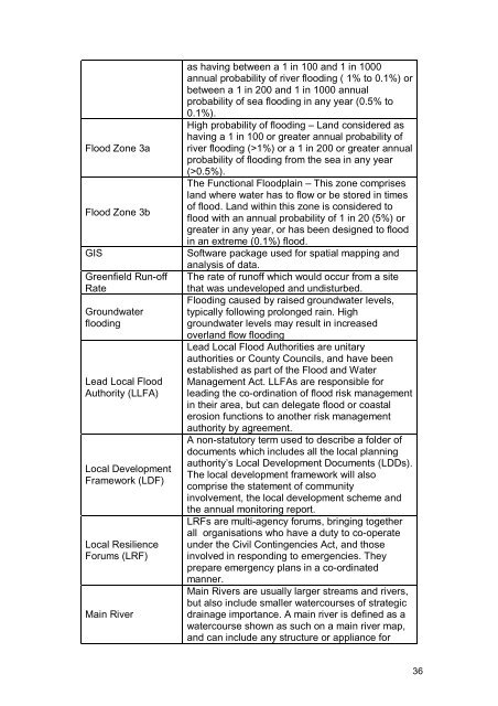
Flood Zone 3aFlood Zone 3bGISGreenfield Run-offRateGroundwaterfloodingLead Local FloodAuthority (LLFA)Local DevelopmentFramework (LDF)Local ResilienceForums (LRF)Main Riveras having between a 1 in 100 and 1 in 1000annual probability of river flooding ( 1% to 0.1%) orbetween a 1 in 200 and 1 in 1000 annualprobability of sea flooding in any year (0.5% to0.1%).High probability of flooding – Land considered ashaving a 1 in 100 or greater annual probability ofriver flooding (>1%) or a 1 in 200 or greater annualprobability of flooding from the sea in any year(>0.5%).The Functional Floodplain – This zone comprisesland where water has to flow or be stored in timesof flood. Land within this zone is considered toflood with an annual probability of 1 in 20 (5%) orgreater in any year, or has been designed to floodin an extreme (0.1%) flood.Software package used for spatial mapping andanalysis of data.The rate of runoff which would occur from a sitethat was undeveloped and undisturbed.Flooding caused by raised groundwater levels,typically following prolonged rain. Highgroundwater levels may result in increasedoverland flow floodingLead Local Flood Authorities are unitaryauthorities or <strong>County</strong> <strong>Council</strong>s, and have beenestablished as part of the Flood and <strong>Water</strong><strong>Management</strong> Act. LLFAs are responsible forleading the co-ordination of flood risk managementin their area, but can delegate flood or coastalerosion functions to another risk managementauthority by agreement.A non-statutory term used to describe a folder ofdocuments which includes all the local planningauthority’s Local Development Documents (LDDs).The local development framework will alsocomprise the statement of communityinvolvement, the local development scheme andthe annual monitoring report.LRFs are multi-agency forums, bringing togetherall organisations who have a duty to co-operateunder the Civil Contingencies Act, and thoseinvolved in responding to emergencies. Theyprepare emergency plans in a co-ordinatedmanner.Main Rivers are usually larger streams and rivers,but also include smaller watercourses of strategicdrainage importance. A main river is defined as awatercourse shown as such on a main river map,and can include any structure or appliance for36


