Surface Water Management Plan - Hampshire County Council
Surface Water Management Plan - Hampshire County Council
Surface Water Management Plan - Hampshire County Council

Create successful ePaper yourself
Turn your PDF publications into a flip-book with our unique Google optimized e-Paper software.
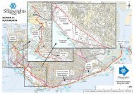
<strong>Hampshire</strong> <strong>Surface</strong> <strong>Water</strong> <strong>Management</strong> <strong>Plan</strong>s (SWMP)- EastleighExecutive SummaryThis is one of a suite of <strong>Surface</strong> <strong>Water</strong> <strong>Management</strong> <strong>Plan</strong>s being prepared fordistricts in <strong>Hampshire</strong>. By 2015 it is anticipated that there will be full coverageof all <strong>Hampshire</strong> districts with SWMPs.The document has been prepared by <strong>Hampshire</strong> <strong>County</strong> <strong>Council</strong> inconjunction with stakeholder and partner organisations through a stakeholderofficer group comprising representatives from the relevant district council andadjoining authorities, the Environment Agency and the water companies.The document focuses on surface water flood risk in Eastleigh borough. Itshould be read alongside the Strategic Overview and Background InformationSWMP document which provides a context for this report and the others to beprepared in future.The document describes the topography, geology and hydrology of Eastleighborough and describes other significant features which can impact on surfacewater flood risk. It collates and assesses historic data on surface water floodevents in Eastleigh and uses Defra / Environment Agency mapping data andprojections to determine likely future flood risk taking into account the impactsof climate change.This data is described and assessed by Parish (including the un-parishedarea of Eastleigh town itself) looking at each area’s susceptibility to floodingbased on information from past flood events and the likelihood of futureflooding based on national modelling data.This allows a hierarchy of flood risk in the borough to be identified along withsurface water flooding ‘hotspots’ where further, more detailed work may berequired into the causes of, and possible responses to, flood risk. It highlightswhat solutions may be required to address and/or mitigate flood risk in those‘hotspot’ areas and where further investigation is recommended.Flood risk management responses are proposed which cover a range of areasincluding effective communication, policy responses and physical works.Ultimately the aim of identifying hotspots is to bring these areas to theattention of all parties who may be able to influence and reduce flood risk.This SWMP report will continue to evolve as flood risk is better understoodand as additional flood risk areas are identified, ultimately leading to areduction in the risk of flooding as well as an increase in the understanding offlood risk across the borough.