Edgeworth Renewal Corridor Project - Lake Macquarie City Council
Edgeworth Renewal Corridor Project - Lake Macquarie City Council
Edgeworth Renewal Corridor Project - Lake Macquarie City Council

Create successful ePaper yourself
Turn your PDF publications into a flip-book with our unique Google optimized e-Paper software.
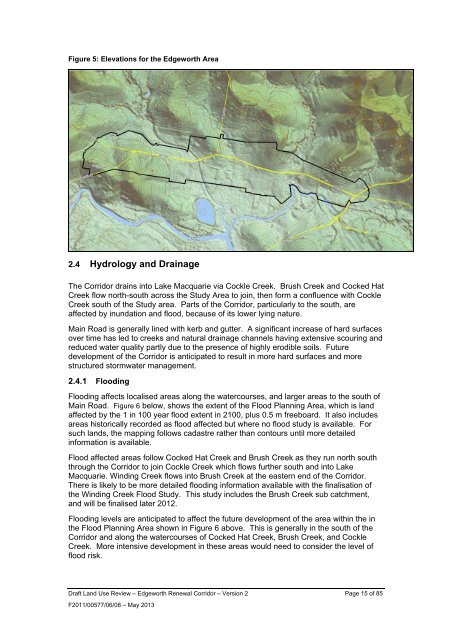
Figure 5: Elevations for the <strong>Edgeworth</strong> Area2.4 Hydrology and DrainageThe <strong>Corridor</strong> drains into <strong>Lake</strong> <strong>Macquarie</strong> via Cockle Creek. Brush Creek and Cocked HatCreek flow north-south across the Study Area to join, then form a confluence with CockleCreek south of the Study area. Parts of the <strong>Corridor</strong>, particularly to the south, areaffected by inundation and flood, because of its lower lying nature.Main Road is generally lined with kerb and gutter. A significant increase of hard surfacesover time has led to creeks and natural drainage channels having extensive scouring andreduced water quality partly due to the presence of highly erodible soils. Futuredevelopment of the <strong>Corridor</strong> is anticipated to result in more hard surfaces and morestructured stormwater management.2.4.1 FloodingFlooding affects localised areas along the watercourses, and larger areas to the south ofMain Road. Figure 6 below, shows the extent of the Flood Planning Area, which is landaffected by the 1 in 100 year flood extent in 2100, plus 0.5 m freeboard. It also includesareas historically recorded as flood affected but where no flood study is available. Forsuch lands, the mapping follows cadastre rather than contours until more detailedinformation is available.Flood affected areas follow Cocked Hat Creek and Brush Creek as they run north souththrough the <strong>Corridor</strong> to join Cockle Creek which flows further south and into <strong>Lake</strong><strong>Macquarie</strong>. Winding Creek flows into Brush Creek at the eastern end of the <strong>Corridor</strong>.There is likely to be more detailed flooding information available with the finalisation ofthe Winding Creek Flood Study. This study includes the Brush Creek sub catchment,and will be finalised later 2012.Flooding levels are anticipated to affect the future development of the area within the inthe Flood Planning Area shown in Figure 6 above. This is generally in the south of the<strong>Corridor</strong> and along the watercourses of Cocked Hat Creek, Brush Creek, and CockleCreek. More intensive development in these areas would need to consider the level offlood risk.Draft Land Use Review – <strong>Edgeworth</strong> <strong>Renewal</strong> <strong>Corridor</strong> – Version 2 Page 15 of 85F2011/00577/06/08 – May 2013