Analisies of exsisting situation on dumpsite Vrtijeljka.pdf
Analisies of exsisting situation on dumpsite Vrtijeljka.pdf
Analisies of exsisting situation on dumpsite Vrtijeljka.pdf

You also want an ePaper? Increase the reach of your titles
YUMPU automatically turns print PDFs into web optimized ePapers that Google loves.
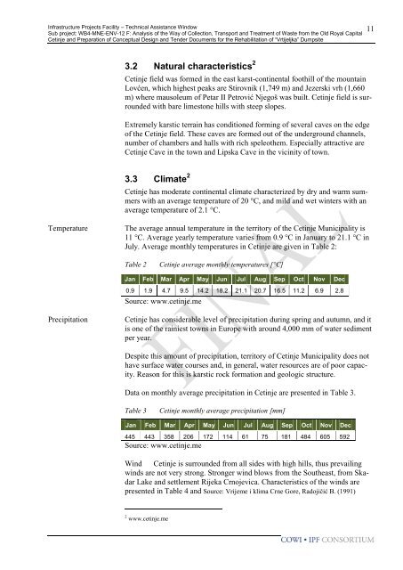
Infrastructure Projects Facility – Technical Assistance WindowSub project: WB4-MNE-ENV-12 F: Analysis <str<strong>on</strong>g>of</str<strong>on</strong>g> the Way <str<strong>on</strong>g>of</str<strong>on</strong>g> Collecti<strong>on</strong>, Transport and Treatment <str<strong>on</strong>g>of</str<strong>on</strong>g> Waste from the Old Royal CapitalCetinje and Preparati<strong>on</strong> <str<strong>on</strong>g>of</str<strong>on</strong>g> C<strong>on</strong>ceptual Design and Tender Documents for the Rehabilitati<strong>on</strong> <str<strong>on</strong>g>of</str<strong>on</strong>g> “<strong>Vrtijeljka</strong>” Dumpsite113.2 Natural characteristics 2Cetinje field was formed in the east karst-c<strong>on</strong>tinental foothill <str<strong>on</strong>g>of</str<strong>on</strong>g> the mountainLovćen, which highest peaks are Stirovnik (1,749 m) and Jezerski vrh (1,660m) where mausoleum <str<strong>on</strong>g>of</str<strong>on</strong>g> Petar II Petrović Njegoš was built. Cetinje field is surroundedwith bare limest<strong>on</strong>e hills with steep slopes.Extremely karstic terrain has c<strong>on</strong>diti<strong>on</strong>ed forming <str<strong>on</strong>g>of</str<strong>on</strong>g> several caves <strong>on</strong> the edge<str<strong>on</strong>g>of</str<strong>on</strong>g> the Cetinje field. These caves are formed out <str<strong>on</strong>g>of</str<strong>on</strong>g> the underground channels,number <str<strong>on</strong>g>of</str<strong>on</strong>g> chambers and halls with rich speleothem. Especially attractive areCetinje Cave in the town and Lipska Cave in the vicinity <str<strong>on</strong>g>of</str<strong>on</strong>g> town.3.3 Climate 2Cetinje has moderate c<strong>on</strong>tinental climate characterized by dry and warm summerswith an average temperature <str<strong>on</strong>g>of</str<strong>on</strong>g> 20 °C, and mild and wet winters with anaverage temperature <str<strong>on</strong>g>of</str<strong>on</strong>g> 2.1 °C.TemperatureThe average annual temperature in the territory <str<strong>on</strong>g>of</str<strong>on</strong>g> the Cetinje Municipality is11 °C. Average yearly temperature varies from 0.9 °C in January to 21.1 °C inJuly. Average m<strong>on</strong>thly temperatures in Cetinje are given in Table 2:Table 2Cetinje average m<strong>on</strong>thly temperatures [°C]Jan Feb Mar Apr May Jun Jul Aug Sep Oct Nov Dec0.9 1.9 4.7 9.5 14.2 18.2 21.1 20.7 16.5 11.2 6.9 2.8Source: www.cetinje.mePrecipitati<strong>on</strong>Cetinje has c<strong>on</strong>siderable level <str<strong>on</strong>g>of</str<strong>on</strong>g> precipitati<strong>on</strong> during spring and autumn, and itis <strong>on</strong>e <str<strong>on</strong>g>of</str<strong>on</strong>g> the rainiest towns in Europe with around 4,000 mm <str<strong>on</strong>g>of</str<strong>on</strong>g> water sedimentper year.Despite this amount <str<strong>on</strong>g>of</str<strong>on</strong>g> precipitati<strong>on</strong>, territory <str<strong>on</strong>g>of</str<strong>on</strong>g> Cetinje Municipality does nothave surface water courses and, in general, water resources are <str<strong>on</strong>g>of</str<strong>on</strong>g> poor capacity.Reas<strong>on</strong> for this is karstic rock formati<strong>on</strong> and geologic structure.Data <strong>on</strong> m<strong>on</strong>thly average precipitati<strong>on</strong> in Cetinje are presented in Table 3.Table 3Cetinje m<strong>on</strong>thly average precipitati<strong>on</strong> [mm]Jan Feb Mar Apr May Jun Jul Aug Sep Oct Nov Dec445 443 358 206 172 114 61 75 181 484 605 592Source: www.cetinje.meWind Cetinje is surrounded from all sides with high hills, thus prevailingwinds are not very str<strong>on</strong>g. Str<strong>on</strong>ger wind blows from the Southeast, from SkadarLake and settlement Rijeka Crnojevica. Characteristics <str<strong>on</strong>g>of</str<strong>on</strong>g> the winds arepresented in Table 4 and Source: Vrijeme i klima Crne Gore, Radojičić B. (1991)2 www.cetinje.me.