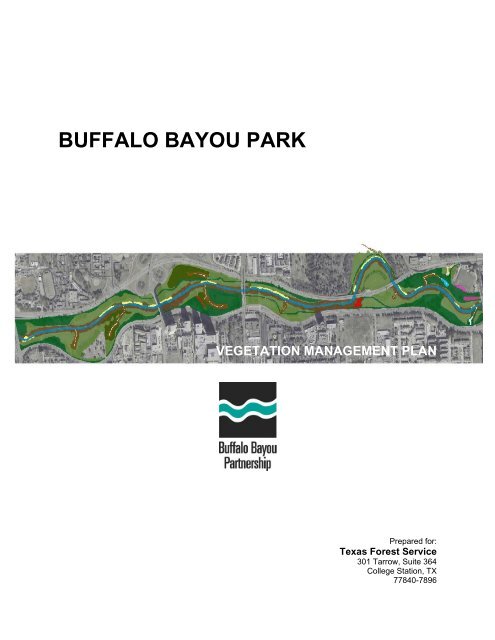
Buffalo Bayou Park Vegetation Management Plan (PDF)
Buffalo Bayou Park Vegetation Management Plan (PDF)
Buffalo Bayou Park Vegetation Management Plan (PDF)

You also want an ePaper? Increase the reach of your titles
YUMPU automatically turns print PDFs into web optimized ePapers that Google loves.
CHAPTER 1OVERVIEW1.1 <strong>Buffalo</strong> <strong>Bayou</strong> <strong>Park</strong> Site <strong>Plan</strong><strong>Buffalo</strong> <strong>Bayou</strong> <strong>Park</strong>Miles0 0.125 0.25 0.5²Existing <strong>Buffalo</strong> <strong>Bayou</strong> <strong>Park</strong> ZonesForested Riparian 19.6 acresForests 6.7 acresGardens 0.7 acresNon-Forested Riparian 2.5 acresWildflower Slopes 0.82 acresActive Use <strong>Park</strong>space 41 acresTributary ChannelPrairie 0.3 acresPassive Use <strong>Park</strong> Space 60 acresRiparian Tributaries 6.8 acresWetland 0.2 acres<strong>Buffalo</strong> <strong>Bayou</strong> WaterwayOctober 2004 1 <strong>Buffalo</strong> <strong>Bayou</strong> <strong>Park</strong> <strong>Vegetation</strong> <strong>Management</strong> <strong>Plan</strong><strong>Buffalo</strong> <strong>Bayou</strong> Partnership
Chapter 1Overview1.3 How to Use This <strong>Plan</strong>The purpose of the <strong>Buffalo</strong> <strong>Bayou</strong> <strong>Vegetation</strong> <strong>Management</strong> <strong>Plan</strong> is to direct vegetation management insignificant zones in <strong>Buffalo</strong> <strong>Bayou</strong> <strong>Park</strong>. It is not intended to be used as a technical manual for habitatrestoration, rather as basic guidelines for increasing species diversity and wildlife habitat, stabilizing<strong>Bayou</strong> banks in the <strong>Park</strong> and increasing the aesthetic value of the <strong>Park</strong>. Further, the VMP was written tobe understood and used for maintenance managers and personnel using basic landscape and restorationprinciples.Depending on the intended function, individual sections will apply to individual goals being accomplished.The VMP is meant to be broad enough to apply anywhere along the <strong>Bayou</strong> and specific enough to guidepractical care of <strong>Buffalo</strong> <strong>Bayou</strong> <strong>Park</strong>’s natural resources. This section should provide the essentialinformation to move quickly through the document to reach particular sections of interest. The VMP wasconceived with flexibility and accessibility in mind.Chapters 1 – 4 provide basic information on the park, its problems and needs, its history and baselinevegetation information for ten management zones in the park.Chapter 5 describes each significant management zone. It provides restoration procedures andmanagement recommendations on the three existing significant management zones including theriparian, tributary and forest zones. It also provides establishment procedures and managementrecommendations for three current pilot projects in the park: wetlands, prairies and wildflower slopes.Each section includes a map of the existing area and offers recommendations for future sites of the pilotprojects. A maintenance frequency table, maintenance goals and a plant list appropriate to each zoneare at the end of each section.Chapter 6 provides information on the current maintenance in the <strong>Park</strong> by the City of Houston <strong>Park</strong>s andRecreation Department and technical maintenance information including watering, mulching, pruning,fertilizing, disease and pest control, tree removal, invasive species control and herbicide use.Chapter 7 describes erosion types occurring in the <strong>Park</strong>. It proposes a particular site that was chosenbecause the erosion occurring is undercutting the parks hike and bike trail. Finally, it recommendsstreambank stabilization objectives for the site.October 2004 3 <strong>Buffalo</strong> <strong>Bayou</strong> <strong>Park</strong> <strong>Vegetation</strong> <strong>Management</strong> <strong>Plan</strong><strong>Buffalo</strong> <strong>Bayou</strong> Partnership
CHAPTER TWOGOALS AND OBJECTIVESChapter 2Goals and Objectives2.1 Overall Goals of the West SectorNo comprehensive vegetation management plan has been developed and implemented for the ecologicalfunctioning of <strong>Buffalo</strong> <strong>Bayou</strong> <strong>Park</strong>. Current vegetation maintenance practices in the corridor includemowing terraced, turf conditions and pruning trees within the turf. Although maintained turf parkspace isan overwhelming portion of the West Sector, areas that go neglected by maintenance can potentiallycreate the most interesting and unique features of the corridor. Some managed parkspace currentlyrequiring intense maintenance can be converted to more sustainable conditions that will decreasemaintenance while providing a richer aesthetic and ecological value to the <strong>Park</strong>.2.2 Urban Forestry GoalsUrban forestry, “the study of trees and forests in and around towns and cities” is essential to the health ofthe West Sector trees and forests (EPA). The following goals were developed to guide the <strong>Buffalo</strong> <strong>Bayou</strong>Partnership’s Urban Forester to begin implementing the VMP. The Texas Forest Service 2004Partnership Grant Program objectives include:• promoting natural conditions within the corridor;• monitoring trees and forests;• implementing a bioengineered streambank protection demonstration project;• enhancement of the riparian buffer by removing invasive species;• enhancement of the riparian buffer by developing planting plans for native species;• managing Forestry Volunteer Program;• and, increase Public Safety.2.3 <strong>Buffalo</strong> <strong>Bayou</strong> <strong>Park</strong> <strong>Vegetation</strong> <strong>Management</strong> <strong>Plan</strong> Goals and ObjectivesThe primary goal for the VMP is to determine the existing conditions and make recommendations on themanagement for the natural resources within the Sector.Goal: Use best vegetation management practices for the bayou corridorObjectives:• Identify the conditions and needs of the West Sector• Review city, county and state agencies, and other best management practices (BMP’s) foreach condition represented or proposed in the West Sector• Incorporate those BMPs into the maintenance structure of managing agenciesGoal: Protect and enhance native vegetation and natural resourcesObjectives:• Restore forest community with site-specific reforestation projects• Restore and enhance grasslands, wetlands and wildflower slopes• Develop and maintain lists of native vegetation for each area• Increase migratory bird habitat (snags and large native trees)• Make recommendations for the re-establishment of historically existing conditions (includingprairies, vegetated swales, etc.)• Work toward the possible designation of park habitat areas as wildlife areasGoal: Develop a streambank restoration plan utilizing erosion control techniquesObjectives:• Identify a specific location where severe erosion is occurring in the West Sector for ademonstration project• Upon completion of Harris County Flood Control District’s erosion study of the <strong>Buffalo</strong> <strong>Bayou</strong>,apply their recommendations to a demonstration project in the West SectorOctober 2004 4 <strong>Buffalo</strong> <strong>Bayou</strong> <strong>Park</strong> <strong>Vegetation</strong> <strong>Management</strong> <strong>Plan</strong><strong>Buffalo</strong> <strong>Bayou</strong> Partnership
Chapter 2Goals and ObjectivesGoal: Improve the aesthetic value of natural areasObjectives:• Provide maintenance procedures for the perimeter of tributaries, riparian and forest zonesthat will increase the aesthetic value of the corridor• Recommend locations for re-grading the <strong>Bayou</strong> banks for greater visual and pedestrianaccess to the <strong>Bayou</strong>• Enable use and enjoyment of <strong>Buffalo</strong> <strong>Bayou</strong> <strong>Park</strong>’s natural resources while protecting wildlifeand habitatOctober 2004 5 <strong>Buffalo</strong> <strong>Bayou</strong> <strong>Park</strong> <strong>Vegetation</strong> <strong>Management</strong> <strong>Plan</strong><strong>Buffalo</strong> <strong>Bayou</strong> Partnership
CHAPTER 3CONTEXT OF PLANChapter 3Context of <strong>Plan</strong>3.1 West Sector History• 1871 The Glenwood Cemetery opened as a park• 1877 Founding of the Old Sixth Ward, bounded by Memorial Drive, Glenwood Cemetery,Washington Avenue and Houston Avenue• 1880's Daniel Shepherd built a dam at present day Shepherd Drive on <strong>Buffalo</strong> <strong>Bayou</strong>. In time,floods washed away his dam.• 1880’s Beth Yeshurun Cemetery created by the Orthodox Congregation of Adath Yeshurun at3500 Allen <strong>Park</strong>way.• 1912 Arthur Coleman Comey’s <strong>Plan</strong>ning Report for the Houston <strong>Park</strong> Commission publishedas 1 st proposal for <strong>Buffalo</strong> <strong>Bayou</strong> improvements. Comey envisioned a linear park systemalong the city’s waterways.• 1917 Forty-four acres of land on the north bank of <strong>Buffalo</strong> <strong>Bayou</strong> between Studemont Streetand Waugh Drive became Vick's <strong>Park</strong>. This tract included a small oxbow lake, calledVick’s Lake. Later, the park was incorporated as a part of Cleveland <strong>Park</strong> and the VicksLake oxbow was filled and contoured during the construction of Memorial Drive and theWaugh Drive cloverleaf. Today, a portion of the former park site remains at Spotts <strong>Park</strong>.• 1926 Creation of <strong>Buffalo</strong> <strong>Bayou</strong> <strong>Park</strong> between Taft Street and Sabine Street aimed at linkingDowntown with the nearby suburban area of River Oaks and preserving urban waterfrontgreenspace, including an attractive, lush segment of the <strong>Bayou</strong>. <strong>Buffalo</strong> <strong>Bayou</strong> <strong>Park</strong>extends from Shepherd Drive along the south side of the bayou to Sam Houston <strong>Park</strong>.• 1929 Severe flood causing millions of dollars in damage.• 1953-58 Channelization of <strong>Buffalo</strong> <strong>Bayou</strong> between Shepherd and Sabine by the Army Corps ofEngineers to improve floodwater conveyance to Galveston Bay. In conjunction with theconstruction of Memorial Drive into downtown, the banks of the bayou were cleared oftheir natural woodland environment. Both sides were scraped, as the process was called,and most of the trees were removed to be replaced by landscaped, grassy banks. Workalso removed the northward curving bend in the bayou at Waugh Drive• 1972 Charles Tapley designed a flowing tributary scheme for a section of the northern banks ofthe West Sector with granite steps and seating areas.• 1978 Wortham Fountain built at Allen <strong>Park</strong>way and Waugh• 1978 Two springs were found; one poured 11 lps from Beaumont sand and shell deposits atStanford Street. The other discharged 0.95 lps at Tirrell Street. Pennywort fringes theflow, shaded by willows. Azaleas bloom in the park in spring. (Springs of Texas 1971).• 1979 “Large Spindle Piece,” a 12-ft. abstract bronze structure by English sculptor Henri Moorewas donated to the City of Houston for placement outdoors. It is located a short distanceupstream of Tinsley <strong>Park</strong>, east of Taft Street on the crest of a low hill between Allen<strong>Park</strong>way and Memorial Drive. The greenbelt area along Allen <strong>Park</strong>way and <strong>Buffalo</strong><strong>Bayou</strong>, where the skyline drops behind fertile foothills of grass, trees, and flowers wasselected as the ideal space that combined the sculptural form with the naturalenvironment.• 1979 Near the Sabine St. bridge, there is a side drainage that enters from the south bank. Asmall riparian plaza has been built at the base of the Heiner St. storm sewer in which fish,turtles and aquatic fowl are seen frequenting this pleasant oasis. Stairs descend fromAllen <strong>Park</strong>way to the plaza as part of the hiking trail that continues under the bridge to theCivic Center area near Sam Houston <strong>Park</strong> and City Hall Annex.• 1980 Spotts <strong>Park</strong>, 16.24 acres, (401 South Heights Boulevard) -acquired by the Houston <strong>Park</strong>s& Recreation Department.• 1987 The creation of the <strong>Buffalo</strong> <strong>Bayou</strong> Art <strong>Park</strong> by a group of artists who wanted a place toexhibit their masterpieces in downtown open-air arenas.• 1992 The Police Officers’ Memorial was erected across from Memorial Drive. Created by JesusBautista Moroles, consisting of a five stepped pyramid in a ziggurat design (each 40 ftsquare at the base) formed together in a Greek cross shape. A 12.5 ft central pyramidrises from ground to apex. There is a reflecting pool surrounded by four inscribed slabs ofTexas pink granite at the apex.October 2004 6 <strong>Buffalo</strong> <strong>Bayou</strong> <strong>Park</strong> <strong>Vegetation</strong> <strong>Management</strong> <strong>Plan</strong><strong>Buffalo</strong> <strong>Bayou</strong> Partnership
Chapter 4Assessment of Existing ResourcesZone 1Zone 2Zone 3Zone 4Zone 5Zone 6Zone 7Zone 8Zone 9RiparianTributariesForestsWildflower SlopesPrairieWetlandsMaintained Active-use <strong>Park</strong>spaceMaintained Passive-use <strong>Park</strong>spaceOrnamental GardensSubsequent to channelization in the 1950’s, portions of the West Sector were turned into usable parkspace planted with specimen trees and Bermuda grass turf establishing vast lawn-like space. Otherareas, where the ground depressed and held water, or areas that contained a relatively constant sourceof running water were allowed to reseed with the deposition of seeds from birds, wind and flooding.Leaving these areas alone allowed them to succeed under semi-natural conditions enabling both nativeand invasive vegetation to establish and flourish. <strong>Park</strong> zones vary in composition from highly managedlandscape and lawn areas containing controlled species growth, to natural conditions of native riparianand forest remnants. Other natural areas such as prairies and wildflower slopes have been carved fromthe existing maintained areas of the park.In wooded zones, the most common, oldest and significant tree species are noted as the “dominant treespecies”, while shrub species covering over 10% of area are recorded as “dominant shrub species.”Common grasses and forbs are recorded as “dominant non-woody.” Invasive species, covering largeportions of zones are recorded as “dominant invasive spp.” For maintained landscapes, groundcover andcanopy were recorded.4.7 <strong>Vegetation</strong> ZonesZone 1 Riparian Edge of <strong>Buffalo</strong> <strong>Bayou</strong>Acreage:19.6 acresSlope:North and SouthSoils Present:SedimentCanopy Closure: 60-75%Dominant Trees:black willow, elderberry, cottonwood, red mulberry,rough-leaf dogwoodDominant Shrubs:yaupon hollyDominant Non-Woody:romerillo, Philadelphia fleabane, Paspallum spp.Dominant Vines:morning glory, mustang grapeDominant Invasive Spp:giant ragweed, love in a puff, Johnson grass,Chinaberry, Chinese tallowThe riparian zone of <strong>Buffalo</strong> <strong>Bayou</strong> contains both heavily woody conditions and bare slopes of exposedsediment with relatively few native herbaceous plants. Approximately one-quarter mile of bank has beenstabilized using brick, and another 870 feet with gabion baskets and riprap. No restoration work usingbioengineering techniques or managed succession is known to have occurred within the <strong>Park</strong>. Becauseriparian conditions are largely limited by swaled or sloped maintained park space, pioneer species havelittle or no room to establish after the existing vegetation is gone. Areas that are wide enough aretypically overwhelmed by invasive plants that have poor stabilization capabilities.October 2004 9 <strong>Buffalo</strong> <strong>Bayou</strong> <strong>Park</strong> <strong>Vegetation</strong> <strong>Management</strong> <strong>Plan</strong><strong>Buffalo</strong> <strong>Bayou</strong> Partnership
Chapter 4Assessment of Existing ResourcesZone 2 TributariesAcreage:6.8 acresSoils:SedimentCanopy: 80-90%Dominant Trees:bald cypress, black willow, river birch, roughleafdogwood, elderberry,Dominant Shrubs:wax myrtleDominant Non-Woody:turk’s cap, Philadelphia fleabane, lantanaDominant Vinesmorning glory, poison ivy, passion flowerDominant Invasive Spp:giant ragweed, Johnson grass, giant reed, Chinesetallow, ChinaberryDown Woody Debris (ave/acre)n/aSnags/acre 3Tributaries contain a mixture of native, non-native and invasive plants. Three tributaries have had initialrestoration work done to them including plantings native trees and various native groundcover forstabilization after invasive plants have been weeded. Much of this work has been done on a volunteerbasis typically involving weeding, litter removal and tree planting. For the most part, these smalltributaries in the <strong>Park</strong> have gone unmaintained and unnoticed for decades.Zone 3 ForestAcreage:6.7 acresSoils:Clay and fill materialCanopy: 70-85%Dominant Trees:cottonwood, sycamore, water oak, elderberryDominant Shrubs:n/aDominant Non-Woody:Philadelphia fleabane, lantanaDominant Vinesmustang grape, morning glory, poison ivy, passionflowerDominant Invasive Spp:giant ragweed, Chinaberry, Chinese tallowForests, existing around tributaries and small pools on the West end of the park have been allowed togrow without interference from PARD maintenance. The largest forest on the southwest side of the parkis seasonally flooding acting as a green tree reservoir (although it is currently unknown if it functionsecologically as a green tree reservoir) while the other forest areas on the southside are expanded regionsof tributaries. These areas have tremendous potential to become accessible native tree stands with theestablishment of hiking trails. Currently they have little to no access due to dense stands of invasivespecies that block their perimeter. Leaving the forest neglected creates numerous problems includingsafety issues, homeless shelters and storehouses for invasive species that are allowed to reseed theforest year after year.Zone 4 Wildflower slopesAcreage:Soils:Canopy:Dominant Trees:Dominant Shrubs:Dominant Non-Woody:Dominant Invasive Spp:1.5 acresClay filln/an/an/abee-balm, black-eyed Susan, phlox, clasping-leafconeflower, skullcap, Texas vervain, Indian blanket,bluebonnet, lance-leaf loosestrifeBermuda grass, giant ragweedTwo slopes in the West Sector are currently classified as wildflower slopes. Established in the fall of 2003they have done very well for their first year blooming all spring and summer. The slopes were mowed bythe <strong>Park</strong>s Department in July. A second annual seeding will be performed in November 2004.October 2004 10 <strong>Buffalo</strong> <strong>Bayou</strong> <strong>Park</strong> <strong>Vegetation</strong> <strong>Management</strong> <strong>Plan</strong><strong>Buffalo</strong> <strong>Bayou</strong> Partnership
Chapter 4Assessment of Existing ResourcesZone 5 PrairieAcreage:Soils:Canopy:Dominant Trees:Dominant Shrubs:Dominant Non-Woody:Dominant Invasive Spp:0.5 acresAlluvial, clay fill materialn/an/an/abee-balm, common sunflower, clasping-leafconeflower, foxtail, little bluestem, Paspallum floridanumgiant ragweed, bermuda grassOne half-acre prairie exists in the West Sector. It started as a demonstration project in 2003 to determineestablishment procedures, maintenance and long-term management of prairies. The area was mowed bythe <strong>Park</strong>s Department in July and has since been mowed on a 14-day cycle, possibly causing summerand fall forbs and grasses to be lost. Before mowing, maintenance for the prairie included removinginvasive giant ragweed three times during the spring and summer.Future sites for more prairie restoration projects will be limited to level areas between the riparian zoneand the first sideslope. These surfaces are the least used as recreational space and offer better growingconditions than higher terraces. Criteria for selected areas for the establishment of prairies includedlocation, pedestrian access, pedestrian visibility, prior use and environmental conditions.Zone 6 WetlandsAcreage:0.25 acresSoils:ClayCanopy: 20-30%Dominant Trees:bald cypress, black willow, sweet-bay magnoliaDominant Shrubs:yaupon hollyDominant Non-Woody:spikerush, pickerel weed, grassy arrowhead, southernblue-flag iris, spiderwort, white-topped sedgeDominant Invasive Spp:alligatorweed, wediliaOnly one wetland has been established in the West Sector. Located at the head of the Tapley Tributaryat the northeast end of the park, this man-made wetland created by combined community effort containsover 20 species of native wetland plants.Zone 8 Maintained Active-Use <strong>Park</strong> SpaceAcreage:41 AcresSlopeVariableSoils Present:Clay fill material, alluvialCanopy Closure 20%Dominant Trees:live oak, Chinese elm, shumard oak, red maple,crape myrtleDominant Shrubs:n/aSignificant Non-woody:Bermuda grassSignificant Invasive Species:n/aDown Woody Debris:n/aTerraced active use park space describes turf areas that are mowed and maintained regularly by PARDand receives more use than zone 9.October 2004 11 <strong>Buffalo</strong> <strong>Bayou</strong> <strong>Park</strong> <strong>Vegetation</strong> <strong>Management</strong> <strong>Plan</strong><strong>Buffalo</strong> <strong>Bayou</strong> Partnership
Chapter 4Assessment of Existing ResourcesZone 9 Maintained Passive-Use <strong>Park</strong> SpaceAcreage:60 acresSlopeVariableSoils Present:Clay fill material, alluvialCanopy Closure 30%Dominant Trees:live oak, Chinese elm, shumard Oak, red Maple,crape myrtleDominant Shrubs:n/aSignificant Non-woody:Bermuda grassSignificant Invasive Species:n/aDown Woody Debris:n/aMaintained passive-use park space is the area mowed and maintained regularly by PARD receiving theleast amount of traffic of the maintained park space. Zone 9 offers the greatest potential to expand andrestore the riparian, tributary and forest zones and establish wildflower slopes and prairies.Terraced turf conditions (active and passive) primarily receive full-sun. Bermuda grass forming a lawnlike appearance serves as a closely cropped ground cover for most of the year. Winter rye overseedingoccurs on an irregular basis. Native and non-native trees, such as live oak, American sycamore andChinese elm have been dispersed throughout to stand as specimens that grow in 360 degrees of turf.They provide shade along trails and throughout the turf. Active and passive turf areas are mowed andpruned on a 14-day summer cycle. Trees along the trail are generally pruned to 8 feet high; along theroad 14 feet; and those trees that are neither along trails and roads are pruned high enough for PARDmowers to move under their canopy.Zone 10Ornamental GardensCount: 2Acreage:0.7 acresSoils Present:Transplanted Top Soil with clay-fill baseCanopy Closure: 75-85%Dominant Trees:live oakDominant Shrubs:azaleas,Dominant non-woody:Rotating showy forbsDominant Invasive Spp:giant caneThe Jane Gregory Garden and the Wortham Fountain Garden are more formal gardens containing a mixof showy native and non-native herbaceous plants backed by stands of trees and shrubs. Tree canopyabove the gardens are pruned back to allow sunlight to penetrate to the gardens and allow pedestrianaccess. The Jane Gregory Garden has a path winding through it and a bench to sit under the trees.Gardens are mulched annually and receive spring plantings by PARD.October 2004 12 <strong>Buffalo</strong> <strong>Bayou</strong> <strong>Park</strong> <strong>Vegetation</strong> <strong>Management</strong> <strong>Plan</strong><strong>Buffalo</strong> <strong>Bayou</strong> Partnership
CHAPTER FIVESIGNIFICANT MANAGEMENT ZONES<strong>Buffalo</strong> <strong>Bayou</strong> <strong>Park</strong>: Significant <strong>Management</strong> ZonesMiles ²0 0.125 0.25 0.5LegendForests 6.7 acresForested Riparian 19.6 acresRiparian Tributaries 6.8 acresPrairie 0.3 acresProposed Prairie 8.3 arcresWildflower Slopes 0.82 acresProposed Wildflower Slopes 4.0 acresWetland 0.2 acresProposed Wetlands 1.6 acres<strong>Buffalo</strong> <strong>Bayou</strong> WaterwayOctober 2004 13 <strong>Buffalo</strong> <strong>Bayou</strong> <strong>Park</strong> <strong>Vegetation</strong> <strong>Management</strong> <strong>Plan</strong><strong>Buffalo</strong> <strong>Bayou</strong> Partnership
Chapter 5Significant <strong>Management</strong> ZonesSignificant <strong>Management</strong> Zones (SMZ) are those areas in the <strong>Park</strong> that require maintenance beyond thecurrent practices of the PARD, the <strong>Buffalo</strong> <strong>Bayou</strong> Partnership and other groups that work in the park. Sixof the ten vegetative zones have been classified as significant management zones. They were classifiedas such because they offer the greatest potential to preserve and protect aquatic resources, restoreecological integrity, restore natural structure, restore natural function, address ongoing causes ofdegradation and restore self-sustainability (EPA: River Corridor and Wetland Restoration). They alsocontain unique features such as upper canopy forest and small, flowing streams that, with propermanagement, add interest and aesthetic value to the <strong>Bayou</strong>.Sections 5.1, 5.2 and 5.3 SMZ’s are already established throughout the <strong>Park</strong>. These areas need to berestored and managed for them to provide greater benefits to the <strong>Park</strong>. Sections 5.4, 5.5 and 5.6 SMZ’sexist in the park only as pilot projects. These zones are included here because of the success of the pilotprojects for increasing species diversity, wildlife habitat and park interest. Procedures for establishmentare recommended here on the basis of the lessons learned in the pilot project.October 2004 14 <strong>Buffalo</strong> <strong>Bayou</strong> <strong>Park</strong> <strong>Vegetation</strong> <strong>Management</strong> <strong>Plan</strong><strong>Buffalo</strong> <strong>Bayou</strong> Partnership
5.1 Riparian <strong>Management</strong> Zone (RMZ)<strong>Buffalo</strong> <strong>Bayou</strong> <strong>Park</strong>: <strong>Bayou</strong> Riparian AreaMiles²0 0.125 0.25 0.5LegendForested Riparian 19.6 acres<strong>Bayou</strong> Riparian i.d.Non-Forested Riparian 2.5 acresNon-Forested Riparian i.d.<strong>Bayou</strong> Riparian Restoration Project Riparian after Ragweed Removal!!October 2004 15 <strong>Buffalo</strong> <strong>Bayou</strong> <strong>Park</strong> <strong>Vegetation</strong> <strong>Management</strong> <strong>Plan</strong><strong>Buffalo</strong> <strong>Bayou</strong> Partnership
Chapter 5Significant <strong>Management</strong> ZonesRiparian areas, also known as riparian zones, streamside zones, stream protection zones and bufferstrips, are the transitional boundaries between aquatic and terrestrial ecosystems. This unique conditioncontributes to water quality by removing pollutants, nutrients and sediment, reducing sheetflowmaintaining lower water temperatures and creating aquatic habitat. The riparian ecosystem alsoenhances wildlife habitat on land and greatly increases biological diversity of a region. In addition to theirecological importance, riparian conditions provide a range of functions with economic and social value.(Kilgore,4).In the West Sector, the riparian zone is generally the area between the bayou channel and the point atwhich PARD stops mowing managed parkspace, or the transition from the <strong>Bayou</strong> to a tributary.Numerous studies report that potential contributions of riparian vegetation to the ecological functionswithin a stream are present within the first 15 to 100 feet from the stream bank. “RMZ widths in that rangetypically provide at least 50 percent of potential effectiveness and often 75 percent or greatereffectiveness at protecting various stream functions” (Castelle and Johnson 2000).The riparian zone of the West Sector varies greatly in size and condition. Some portions containovergrown understories consisting of tall invasive plants such as giant ragweed with an upper canopyengrossed in vines; a vegetative condition typical of riparian transitioning into a forested tributary. Otherportions are barren eroding banks. Eroding banks with no upper canopy are dominated by giant ragweedleaving them susceptible to further erosion requiring streambank stabilization intervention to restabilize aneroding bank. Other sections of the riparian zone are over 20 feet wide with a strong bank composed ofadequate species diversity.Restoration and <strong>Management</strong> RecommendationsObjectives:• Establish section boundaries and needs• Remove invasive and noxious vegetation• Re-establish native riparian vegetation• Prune hazardous trees and specific visual obstructions• Develop a maintenance scheduleArea: 20 acres corresponding to <strong>Vegetation</strong> Zone 1Restoration:When restoring the riparian zone, divide the area into manageable plots to restore sections at a time.Where possible, use natural breaks and begin with sections that offer the most to the corridor in bothappearance and function. After assessing the boundary and condition of the site, outline the stepsneeded for restoration. Restoration of 20 foot wide and greater thriving natural riparian sections will onlyinvolve routine fringe maintenance of ragweed, pruning hazard branches, cut-treat herbicide applicationsto invasive trees and planting native understory vegetation. Under 20 to 30 feet wide, native woody andherbaceous riparian vegetation should be planted through managed parkspace to increase the width ofthe section with desired species. Sections of severe erosion will require streambank stabilization and theestablishment of a minimum 20 foot riparian zone planted with native riparian vegetation.Canopy: Dominant trees throughout the RMZ include black willow (Salix nigra), cottonwood (Populusdeltoids), elderberry (Sambucus canadensis), American sycamore (<strong>Plan</strong>tanus occidentalis), rough-leafdogwood (Cornus drummondii).Understory: Along the tree line, dominant vegetation includes rough-leaf dogwood (Cornus drummondii),elderberry (Sambucus canadensis), romerillo (Bidens alba), morning glory (Ipomoea cordatortriloba),Philadelphia fleabane (Erigeron philadelphicus), wood sorrel (Dryopteris marginalis), and commonsunflower (Helianthus annuus).Invasive plants: Giant ragweed (Ambrosia trifida) dominates canopy fringes along the bank and intreeless areas. Woody invasive species include Chinaberry (Melia azedarach) and Chinese tallow(Sapium sebiferum). On the western end, dense stands of Chinaberry cover the south banks.October 2004 16 <strong>Buffalo</strong> <strong>Bayou</strong> <strong>Park</strong> <strong>Vegetation</strong> <strong>Management</strong> <strong>Plan</strong><strong>Buffalo</strong> <strong>Bayou</strong> Partnership
RIPARIAN MAINTENANCE FREQUENCY SCHEDULE:MonthChapter 5Significant <strong>Management</strong> ZonesMaintenance <strong>Management</strong>NJan Feb Mar Apr May June July Aug Sept OctPracticesovDec TotalWeeding & Invasive sppTrees x 1Shrubs x x 2Herbs x x x x X 5Tree Pruning x x x x 4<strong>Plan</strong>tingsTreesShrubsHerbsFringe Mowing x x x x 4Indicates range of time to perform maintenancex Indicates specific times to perform maintenanceWEEDING AND INVASIVE SPECIES CONTROLWeeding in the riparian zone should be done in sections, beginning with the most visible areas. Weedingthe east and west ends, Eleanor Tinsley <strong>Park</strong> and <strong>Bayou</strong> edges around tributaries will visually expose thewaterway to park users and vehicular traffic on Allen <strong>Park</strong>way and Memorial Drive. Because the <strong>Bayou</strong> isa virtual seed highway, rising water consistently delivers new seeds that must be addressed during thesummer months. Weed as needed during the growing season and should be done monthly in newlyplanted areas. Manage woody invasive species in July and August before the tree goes dormant. Toprohibit coppicing re-growth of woody species a systemic herbicide will be used. A complete list ofacceptable herbicides used for invasive species control is located in Appendix III.REMOVING PLANTSUnlike invasive species, the removal of native trees should be conducted only under the followingconditions:• To relieve conditions where floatable materials caught in foliage and unnatural eddies causeflooding or danger on the waterway,• To remove hazardous trees threatening the safety of maintenance personnel or park users,• To allow for more desired trees during the restoration of a site.PRUNING TREESLimit tree pruning within the riparian zone to limbs blocking visual access to specific areas and tooverhanging limbs that back up floatables in the waterway. Procedures for pruning are located in section6.2.PLANTING RIPARIAN VEGETATIONTree and herbaceous planting should primarily occur when widening the riparian zone for bankstabilization and improving ecological integrity. When choosing native plants, those best adapted to theriparian zone for bank stabilization and for water treatment purposes are preferred. A complete list ofriparian vegetation is located at the end of this section. Follow mulching procedures in section 6.2 for anytree installations performed in the riparian zoneMOWINGMow riparian fringes in conjunction with hand weeding and power weeding at least four times per year toprohibit giant ragweed from going to seed and to maintain a clear view of the bayou and native riparianconditions.TWO YEAR CARERiparian care for new plantings is limited to minor pruning and removing invasive species where they mayovertake the natives before they are established.October 2004 17 <strong>Buffalo</strong> <strong>Bayou</strong> <strong>Park</strong> <strong>Vegetation</strong> <strong>Management</strong> <strong>Plan</strong><strong>Buffalo</strong> <strong>Bayou</strong> Partnership
Riparian Restoration <strong>Plan</strong>t ListScientific Name Common Name Type StatusAcer negundo Box Elder TreeBetula nigra River Birch TreeCatalpa bignonioides Southern Catalpa TreeCornus drummondii Rough-leaf Dogwood TreeFraxinus pennsylcanica Green Ash TreeLiquidamber styraciflua Sweetgum TreeMorus rubra Red Mulberry TreePinus taeda Loblolly Pine Tree<strong>Plan</strong>tanus occidentalis American Sycamore TreePopulus deltoids Eastern Cottonwood TreeQuercus nigra Water Oak TreeQuercus phellos Willow Oak TreeQuercus prinus Swamp Chestnut Oak TreeSalix nigra Black Willow TreeSambucus canadensis Elderberry TreeTaxodium distichum Bald Cypress TreeIlex vomitoria Yaupon Holly ShrubChasmanthium latifolia Inland Sea Oats GrassSchizachyrium scoparium Little Bluestem GrassTridens strictus Long-Spike Tridens GrassBidens Alba Romerillo ForbCassia fasciculata Partridge Pea ForbErigeron philadelphicus Daisy Fleabane ForbMelocactus intortus Turk’s Cap ForbPassiflora incarnata Passion Flower ForbChapter 5Significant <strong>Management</strong> ZonesOctober 2004 18 <strong>Buffalo</strong> <strong>Bayou</strong> <strong>Park</strong> <strong>Vegetation</strong> <strong>Management</strong> <strong>Plan</strong><strong>Buffalo</strong> <strong>Bayou</strong> Partnership
Chapter 5Significant <strong>Management</strong> ZonesTributaries play an important role to the health of stream systems. <strong>Buffalo</strong> <strong>Bayou</strong> <strong>Park</strong> tributaries areformed by stormwater outfalls ending somewhere in the corridor, instead of reaching the actual waterway.The riparian zone of tributaries provides increased opportunities for wildlife habitat, and can function as atreatment zone for effluent, when treatment vegetation is established. Preliminary water tests should berun on the effluent to help determine types of vegetation best suited for each tributary before beginningrestoration. Tributaries also offer a natural aesthetic that park users enjoy seeing and interacting with.Tributary management zones (TMZ) are similar to the <strong>Bayou</strong>’s riparian management zone but include amore diverse topography with intermittent flow. Typically in TMZ’s, the entire channel has an upper treecanopy and the channel itself is between 6 inches and 5 feet wide. Many tributary management zoneshave had deliberate tree and herbaceous vegetation plantings of both native and non-native plants todecrease erosion and for beautification. Maintenance procedures for TMZ’s will follow the sameprocedures as RMZ’s. During restoration some added plant material may vary slightly to increasediversity of the corridor but should be restricted to the TMZ plant list.Restoration and <strong>Management</strong> RecommendationsArea: 6.8 acres corresponding to vegetation zone 2.Objectives:• Increase the riparian width with trees,• Remove invasive species,• Re-establish herbaceous riparian vegetation,• Prune hazard trees and specific visual obstructions.RESTORATIONThe <strong>Bayou</strong> banks once hosted dozens of natural tributaries. Today, these streams have beenchannelized and the water arrives at the <strong>Park</strong> from neighboring areas through storm drains. While theorigins of the tributaries are unlikely to be restored to pre-development conditions, the small areasbetween stormwater outfalls and the <strong>Bayou</strong> itself can improve some ecological benefits to the <strong>Bayou</strong> andthe <strong>Park</strong>.Restoration should begin by removing herbaceous invasive species like ragweed and love in a puff.Mulch the banks after removing large sections of invasives to stabilize the banks and to deter re-growth ofinvasives. Next, use a systemic herbicide to remove invasive trees such as Chinese tallow andchinaberry. Replanting should follow with native trees and understory plants. To provide a dense canopy,trees should be planted throughout the tributaries riparian area and should be extended laterally throughturf parkspace to widen the forest canopy when applicable. This will not only increase wildlife habitat butwill also decrease park maintenance. Additionally, adding rocks and boulders, grading slopes andexcavating pools to establish pool, riffle and run conditions will increase ecological integrity and theaesthetic value of the channel.Canopy: The majority of the native tree canopy is composed of black willow (Salix nigra), bald cypress(Taxodium distichum), water oak (Quercus nigra), elderberry (Sambucus canadensis), red mulberry(Morus rubra), American sycamore (<strong>Plan</strong>tanus occidentalis) and eastern cottonwood (Populus deltoids).Understory: The understory consists of herbaceous plants including Turk’s cap (Melocactus intortus),wedilia (Wedilia trilobata), passion flower (Passiflora incarnata), Paspallum spp., morning glory (Ipomoeacordatortriloba) and mustang grape (Vitis mustangensis).Invasive plants: Invasive species include woody species such as Chinese tallow (Sapium sebiferum),Chinaberry (Melia azedarach); herbaceous plants including giant ragweed (Ambrosia trifida), love in apurr (Cardiospermum halicacabum), Johnson grass (Sorghum halepense) and giant reed (Arundodonax).October 2004 20 <strong>Buffalo</strong> <strong>Bayou</strong> <strong>Park</strong> <strong>Vegetation</strong> <strong>Management</strong> <strong>Plan</strong><strong>Buffalo</strong> <strong>Bayou</strong> Partnership
TRIBUTARY MAINTENANCE FREQUENCY SCHEDULE:MonthChapter 5Significant <strong>Management</strong> ZonesMaintenance <strong>Management</strong>NJan Feb Mar Apr May June July Aug Sept OctPracticesovDec TotalWeeding & Invasive sppTrees x 1ShrubsHerbs x x x x 4Tree Pruning x x x x x x 2<strong>Plan</strong>tingsTrees x x x x 4Shrubs x 1Herbs x x 2Selective Weed Cutting onParameterx x x 3Vine Removal x x x x x 5Indicates range of time to perform maintenancex Indicates specific times to perform maintenanceWEEDING AND INVASIVE SPECIES CONTROLWeeding tributaries should occur primarily around the perimeter of the tree canopy and within thetributary where light penetrates. Relieving the perimeter of tall invasive species allows light into theinterior of the tributary including the waterway to the <strong>Bayou</strong> exposing small rippling falls and pools thathave naturally formed.REMOVING PLANTSRemoval of trees should be conducted with sensitivity to the goals. Most often, the only native trees thatshould be removed are hazardous trees and trees that block access into the tributary and cannot bepruned accordingly. In rare cases, a tree can be removed to allow for more desirable native species.Leave at least 5-10% of the cut woody material inside the tributary to add decomposing wood to the soilsystem.PRUNING TREESTrees along the perimeter should be pruned for two reasons. First, removing low branches around theperimeter enables much easier maintenance of the area. Secondly, it enhances the view into and aroundtributaries and the overall appearance of the tributary. It is also necessary to cut down any hazardoustree limbs in or around the tributary. Because the interior of tributaries often already have a high canopy,little pruning will be necessary inside the riparian zone unless the area has never been pruned or it is ayoung system. In such cases, initial interior pruning may be extensive. Leave at least 5-10% of the cutwoody material inside the tributary. Standard pruning procedures are located in section 6.2.PLANTING RIPARIAN VEGETATIONTree planting can be done either within the tributary when more desirable trees are needed or around theperimeter of the tributary to increase its area and push back ragweed fringes. Understory herbaceousmaterial should be planted to increase diversity and to stabilize tributary banks. Follow mulchingprocedures for any tree installations performed. Establish a 2 inch layer of mulch around herbaceousinstallations.VINE REMOVALVines are often a problem around the perimeter of tributaries. Removing vines is part of the initialmaintenance done around perimeter and from around tree trunks.TWO YEAR CAREContinued removal of giant ragweed will be necessary for the first two years to allow for native plants tobecome established and to maintain its appearance. Watering and periodic stake adjustments and stakeremoval will be necessary to establish new plants. Tree stakes should be removed no earlier than oneyear after planting and no later than two years.October 2004 21 <strong>Buffalo</strong> <strong>Bayou</strong> <strong>Park</strong> <strong>Vegetation</strong> <strong>Management</strong> <strong>Plan</strong><strong>Buffalo</strong> <strong>Bayou</strong> Partnership
Chapter 5Significant <strong>Management</strong> ZonesTributary Restoration <strong>Plan</strong>t ListScientific Name Common Name Type StatusBetula nigra River Birch TreeCornus drummondii Rough-leaf Dogwood TreeCrataegus marshallii Parsley Hawthorne TreeFraxinus pennsylcanica Green Ash TreeLiquidamber styraciflua Sweetgum TreeMorus rubra Red Mulberry TreePinus taeda Loblolly Pine Tree<strong>Plan</strong>tanus occidentalis American Sycamore TreePopulus deltoids Eastern Cottonwood TreeQuercus nigra Water Oak TreeQuercus phellos Willow Oak TreeQuercus prinus Swamp Chestnut Oak TreeSalix nigra Black Willow TreeSambucus canadensis Elderberry TreeTaxodium distichum Bald Cypress TreeTilia caroliniana Carolina Basswood TreeUlmus crassifolia Cedar Elm TreeIlex vomitoria Yaupon Holly ShrubSymphoricarpos orbiculatus Coral Berry ShrubChasmanthium latifolia Inland Sea Oats GrassSchizachyrium scoparium Little Bluestem GrassTridens strictus Long-Spike Tridens GrassIris virginica Southern Blue Iris ForbBidens Alba Romerillo ForbHymenocallis liriosme Spider Lilly ForbMelocactus intortus Turk’s Cap ForbPassiflora incarnata Passion Flower ForbDryopteris marginalis Common Wood Fern FernLorinseria areolata Chain Fern FernOnoclea sensibilis Sensitive Fern FernParthenocissus quinquefolia Virginia Creeper VineOctober 2004 22 <strong>Buffalo</strong> <strong>Bayou</strong> <strong>Park</strong> <strong>Vegetation</strong> <strong>Management</strong> <strong>Plan</strong><strong>Buffalo</strong> <strong>Bayou</strong> Partnership
5.3 Forest <strong>Management</strong> Zone (FMZ)<strong>Buffalo</strong> <strong>Bayou</strong> <strong>Park</strong>: Forests0 0.125 0.25 0.5Miles²LegendForests 6.7 acresForest exampleRiparian Tributaries 6.8 acresForest Condition From the Trail Interior Conditions of Corridor Forests!!October 2004 23 <strong>Buffalo</strong> <strong>Bayou</strong> <strong>Park</strong> <strong>Vegetation</strong> <strong>Management</strong> <strong>Plan</strong><strong>Buffalo</strong> <strong>Bayou</strong> Partnership
Chapter 5Significant <strong>Management</strong> ZonesThe importance of forests within urban areas cannot be underestimated. Forests provide many functionsto cities including “the absorption of carbon dioxide by trees, reduction in temperature and provision ofhabitat for urban wildlife, they act as natural storm water management areas filtering particulate matter(pollutants, some nutrients, and sediment) and by the absorption of water, and they reduce noise levels,provide recreational benefits and increase property value” (EPA Office of Water).Forest management zones (FMZ’s) between Shepherd Drive and Sabine Street are extended riparianzones of the <strong>Bayou</strong> or its tributaries, or surround ephemeral pools with an average tree canopy at least 30feet beyond the center of the reservoir. These conditions make them difficult to maintain within theframework of PARD maintenance policy. Because there is little or no fringe maintenance of forest’,perimeters form a thick vegetative barrier that discourages accessibility to their interior atmosphere whilealso decreasing the aesthetic value, safety and overall experience of the corridor. Maintenance offorests will create a substantial aesthetic boost to the area with minimal effort.Objectives:• Increase fringe maintenance• Increase the forest acreage through perimeter tree plantings• Remove invasive species• Increase native forest species abundances• Prune hazard trees and specific visual obstructionsActual Area: 6.7 acres corresponding to vegetation zone 3Canopy: Dominant mature trees in forest zones include cottonwood (Populus dactyloides), Americansycamore (<strong>Plan</strong>tanus occidentalis), loblolly pine (Pinus taeda), water oak (Quercus nigra), cedar elm(Ulmus crassifolia), red mulberry (Morus rubra) and green ash (Fraxinus pennsylvanica).Understory: The interior of forest understory receives almost no direct sunlight, allowing few plant speciesto grow. The dominant understory plants found in West Sector forest’ include elderberry (Sambucuscanadensis), flowering dogwood (Cornus florida), southern dewberry (Rubus trivialis) passion flower(Passiflora incarnata), mustang grape (Vitis mustangensis) and poison ivy (Rhus toxicodendron).Invasive species: Invasive species include woody species in the interior such as Chinese tallow (Sapiumsebiferum), chinaberry (Melia axedarach), herbaceous plants on the forest fringe including giant ragweed(Ambrosia trifida), Johnson grass (Sorghum halepense)FOREST MAINTENANCE FREQUENCY SCHEDULE:MonthMaintenance <strong>Management</strong>NJan Feb Mar Apr May June July Aug Sept OctPracticesovDec TotalWeeding & Invasive sppTrees x x 2Shrubs x x 2Herbs x x 2Tree Pruning x x x x 4<strong>Plan</strong>tingsTrees x x x 3Shrubs x x 2Herbaceous x x 2Vine Removal x x x 3Fringe Maintenance x x x x x x 6Indicates range of time to perform maintenancex Indicates specific times to perform maintenanceOctober 2004 24 <strong>Buffalo</strong> <strong>Bayou</strong> <strong>Park</strong> <strong>Vegetation</strong> <strong>Management</strong> <strong>Plan</strong><strong>Buffalo</strong> <strong>Bayou</strong> Partnership
Chapter 5Significant <strong>Management</strong> ZonesINVASIVE SPECIES CONTROLDense stands of giant ragweed and vines are well established along the fringe which needs to bemaintained throughout the spring and summer by bush hogging. Sensitivity should be taken to insure anynative vegetation doesn’t get lost which may require site specific hand weeding. Chinese tallow andchinaberry have established periodically throughout the forest interior, as well as along forest perimeter.Once a year trees and saplings should be cut and treated with herbicide to insure complete removal.Procedures for invasive species control are described in section 6.4.REMOVING PLANTSTree removal should be limited to hazard trees. If a falling tree does not pose a threat to human safety,girdling or trimming to provide snag habitat is preferred to complete removal.PRUNING TREESTree pruning should be limited to low hanging perimeter limbs that prohibit ease of maintenance to thevines and invasive species along the forest fringe. If a trail exists, hazardous tree limbs should beremoved and placed along side the trail to provide a distinct boundary in conjunction with routinemonitoring for new hazards. Large limbs removed during pruning should never be placed directly on treeroot crowns. Standard pruning maintenance is detailed in section 6.2.PLANTING FOREST VEGETATIONAs in any forest, when a tree dies, falls or is removed, pioneer species move in and begin succession. Inan area with little natural habitat such as the West Sector, these locations present an opportunity to plantboth understory and desired saplings to out-compete less desirable species likely to grow, thus increasingdiversity and improving the health of the system from the interior. With any new installation of trees mulchthe base according to mulching procedures in section 6.2.TWO YEAR CAREPerimeter removal of invasive species and low hanging limbs through an establish maintenance programwill enable forests to be viewed, increase safety and reduce homeless shelters. <strong>Plan</strong>ting herbaceousspecies and trees should be monitored on a quarterly basis to ensure the development of natives andwatering, in some cases, may be necessary. If so, a bi-weekly, two year watering schedule should bedeveloped at the time of planting.October 2004 25 <strong>Buffalo</strong> <strong>Bayou</strong> <strong>Park</strong> <strong>Vegetation</strong> <strong>Management</strong> <strong>Plan</strong><strong>Buffalo</strong> <strong>Bayou</strong> Partnership
Chapter 5Significant <strong>Management</strong> ZonesForest Restoration <strong>Plan</strong>t ListScientific Name Common Name Type StatusAcer negundo Box Elder TreeBetula nigra River Birch TreeCarya illinoensis Pecan TreeCeltis occidentalis Hackberry TreeCornus drummondii Rough-leaf Dogwood TreeCornus florida Flowering Dogwood TreeFraxinus pennsylvanica Green Ash TreeLiquidamber styraciflua Sweetgum TreeMagnolia grandiflora Southern magnolia TreeMorus rubra Red Mulberry TreePinus taeda Loblolly Pine Tree<strong>Plan</strong>tanus occidentalis American Sycamore TreePopulus deltoids Eastern Cottonwood TreePrunus caroliniana Cherry-laurel TreeQuercus alba White Oak TreeQuercus falcate Souther Red Oak TreeQuercus laurifolia Laurel Oak TreeQuercus lyrata Overcup Oak TreeQuercus macrocarpa Bur Oak TreeQuercus nigra Water Oak TreeQuercus phellos Willow Oak TreeQuercus prinus Swamp Chestnut Oak TreeQuercus shumardii Shumard Oak TreeSambucus canadensis Elderberry TreeTaxodium distichum Bald Cypress TreeTilia caroliniana Carolina Basswood TreeUlmus crassifolia Cedar Elm TreeIllicuim floridanum Florida Anise ShrubIlex vomitoria Yaupon Holly ShrubItea virginica Virginia Sweetspire ShrubLeucothoe axilliaris Coast Leucothoe ShrubLeucothoe populifolia Florida Leucothoe ShrubSymphoricarpos orbiculatus Coral Berry ShrubBidens Alba Romerillo ForbOxalis stricta Yellow Wood Sorrel ForbPassiflora incarnata Passion Flower ForbPhysla incise Frog Fruit ForbPhysostegia spp. Obedient <strong>Plan</strong>t ForbRivina humilis Pigeonberry ForbRubus trivialis Southern Dewberry ForbStachys coccinea Texas Betony ForbCarex cherokeensis Cherokee Sedge SedgeCarex leavenworthii Little Sedge SedgeChasmanthium latifolia Inland Sea Oats GrassChasmanthium sessiliflora Small Flowered Chasmanthium GrassMuhlenbergia capillaris Gulf Muhley GrassTridens strictus Long-spike Tridens GrassTripsacum dactyloides Eastern Gama Grass GrassDryopteris marginalis Common Wood Fern FernLorinseria areolata Chain Fern FernOnoclea sensibilis Sensitive Fern FernOctober 2004 26 <strong>Buffalo</strong> <strong>Bayou</strong> <strong>Park</strong> <strong>Vegetation</strong> <strong>Management</strong> <strong>Plan</strong><strong>Buffalo</strong> <strong>Bayou</strong> Partnership
5.4 Wildflower Slope <strong>Management</strong> Zone (WMZ)<strong>Buffalo</strong> <strong>Bayou</strong> <strong>Park</strong>: Wildflower SlopesMiles0 0.125 0.25 0.5²LegendEstablished Wildflower Slopes 0.82 acresEstablished Wildflower Slopes i.d.Proposed Wildflower Slopes 4.0 acresProposed Wildflower Slopese i.d.Wildflower Slope Establishment Project Spring Wildflowers!!October 2004 27 <strong>Buffalo</strong> <strong>Bayou</strong> <strong>Park</strong> <strong>Vegetation</strong> <strong>Management</strong> <strong>Plan</strong><strong>Buffalo</strong> <strong>Bayou</strong> Partnership
Chapter 5Significant <strong>Management</strong> ZonesWildflower SlopesWildflower management zones (WMZ’s) are areas where native forbs and grasses have been establishedto increase diversity, butterfly habitat and improve the overall appearance and enjoyment of <strong>Buffalo</strong><strong>Bayou</strong> <strong>Park</strong>. Wildflower slopes also reduce annual maintenance costs, reduce cut organic debris into the<strong>Bayou</strong> and have no impact on floodwater conveyance (HCFCD). North and south facing sideslopes offernumerous locations throughout the <strong>Park</strong> to establish wildflowers. Existing wildflower slopes wereestablished within active and passive use parkspace because few, if any, trees were growing on themand they enabled high visibility with low through traffic. Both existing and other recommended sites forfuture wildflower slopes are identified in map 5.4.Area: 1.5 acres. Boundary corresponds with vegetation zone 4 consisting of two wildflower slopes. Theareas were established in 2003 as a pilot project for <strong>Buffalo</strong> <strong>Bayou</strong> <strong>Park</strong>. They are located just west ofSabine Street on the top two north facing slopes. The largest of the two lies within the <strong>Buffalo</strong> <strong>Bayou</strong>artpark while the second, smaller one is just up the hill. Both can be observed from the Sabine StreetBridge throughout spring and early summer.Groundcover: Dominant forbs include spotted bee balm (Monarda punctata), common sunflower(Helianthus annuus), Drummond’s phlox (Phlox drummondii), skullcap (Scutellaria drummondii), Texasvervain (Verbena halei), brown-eyed Susan (Rudbeckia hirta) and Indian Blanket (Gaillardia pulchella).Invasive and undesired plants: Dominant invasives include giant ragweed (Ambrosia trifida), Bermudagrass (Cynodon dactylon) and Johnson grass (Sorghum halepense).Wildflower Slope Establishment and <strong>Management</strong> RecommendationsObjectives:• Increase wildflower slope acreage (establishment)• Maintain existing wildflower slopes• Re-establish native wildflowers and grasses to <strong>Buffalo</strong> <strong>Bayou</strong> <strong>Park</strong>Establishing a Wildflower Slope in <strong>Buffalo</strong> <strong>Bayou</strong> <strong>Park</strong>The establishment of wildflower slopes begins by choosing an appropriate location that takes into accountland use, visual accessibility, stormwater run-off filtering and erosion control. Recommended slopes areshown in Map 5.4, but there are many other slopes available that will work equally well to establishwildflowers.Step 1: The entire slope being utilized for wildflowers should be mowed as low as possible to expose theground below, 1 to 3 days before being seeded.Step 2: Spread a layer of organic compost over the whole slope at least 1 inch thick. This willsuppress the current groundcover, give the seeds a good soil to establish in and provide nutrientsfor the seeds.Step 3: Spread seeds at approximately 20 lbs. per acres. The seed mix will determine the exact quantityof seed per acre.Step 4: Rake the seeds in lightly over the area so that they are covered by the compost. This will holdseed in place and better protect them over the winter.October 2004 28 <strong>Buffalo</strong> <strong>Bayou</strong> <strong>Park</strong> <strong>Vegetation</strong> <strong>Management</strong> <strong>Plan</strong><strong>Buffalo</strong> <strong>Bayou</strong> Partnership
WILDFLOWER SLOPE MAINTENANCE FREQUENCY SCHEDULE:MonthChapter 5Significant <strong>Management</strong> ZonesMaintenance & <strong>Management</strong>PracticesJan Feb Mar Apr May June July Aug Sept Oct Nov Dec TotalWeeding & Invasive sppShrubsHerbs x x x x 4Tree Pruning x x 2<strong>Plan</strong>tingsTreesShrubsHerbs x 1Seeding x x 2Mowing x x x 3Indicates range of time to perform maintenancex Indicates specific times perform maintenanceWEEDING AND INVASIVE SPECIES CONTROLInvasive species control will be limited to hand pulling weeds. In rare cases, it may be necessary to applya selective herbicide after a site has been seeded with wildflowers. In cases such as the presence ofpoison ivy, herbicides shall be applied following the procedures outlined in Section 6.5.REMOVING PLANTSOther than invasives, removing plants from a site should be performed on a case by case basis.PRUNING TREESCurrently, no trees are established on wildflower slopes. Trees along the fringe of wildflower slopesshould be pruned following procedures in section 6.3.MOWINGMowing should be performed using a brush hog following the wildflower slope frequency table. Cutmaterial should be left on the slope to restore the area and increase slope stability.SEEDING:Seeding occurs between mid October and mid November for best results and, when possible, seedsshould be harvested naturally. Otherwise, insure the seeds purchased are from a source that suppliesseeds native to this region.THREE YEAR CARE:Weeding, mowing and re-seeding are essential in the first three years to establish wildflower slopes.October 2004 29 <strong>Buffalo</strong> <strong>Bayou</strong> <strong>Park</strong> <strong>Vegetation</strong> <strong>Management</strong> <strong>Plan</strong><strong>Buffalo</strong> <strong>Bayou</strong> Partnership
Chapter 5Significant <strong>Management</strong> ZonesWildflower Establishment <strong>Plan</strong>t ListScientific Name Common Name Type StatusAmsonia illustris Showy Blue Star ForbAsclepias longiflora Florida Milkweed ForbAsclepias verticillata Whorled Milkweed ForbAsclepias viridis Green Milkweed ForbCacalia lanceolata Prairie <strong>Plan</strong>tain ForbCassia fasciculata Partridge Pea ForbCentella erecta Erect Centella ForbCooperia drummondi Rain Lilly ForbCracopis amplexicaulis Clasping-leaved Coneflower ForbErigeron philadelphicus Philadelphia Fleabane ForbEryngium yucciflora Rattlesnake Master ForbEupatorium serotinum Boneset ForbEuphorbia bicolor Snow on the Prairie ForbEustoma exaltatum Bluebells ForbEuthamia leptocephala Slender-headed Euthemia ForbGaillardia pulchella Indian Blanket ForbGuara lindheimeri White Guara ForbHelianthus angustifolia Swamp Sunflower ForbHelianthus maximiliani Maximilian Sunflower ForbIpomoea sagittata Morning Glory ForbLiatris acidota Sharp Blazing-Star ForbLiatris bracteata Coastal Gay-feather ForbLiatris pycnostachya Prairie Blazing-Star ForbLobelia puberula Downy Lobelia ForbLupinus texensis Bluebonnet ForbLythrum lanceolatum Lance-leaf Loosestrife ForbManfreda virginica Prairie Agave (American Aloe) ForbMimosa strigillosa Powderpuff ForbMonarda punctata Spotted-Beebalm ForbOenothera speciosa Showy Primrose ForbOxalis stricta Yellow Wood Sorrel ForbOxalis violacea Violet Wood Sorrel ForbPassiflora incarnata Passion Flower ForbPenstemon murrayanus Red Penstemon ForbPetalostemum decumbens Prairie Clover ForbPrunella vulgaris Self Heal ForbRudbeckia hirta Brown-eyed Susan ForbRudbeckia nitida Shining Coneflower ForbRuellia humilus Low Ruellia ForbRuellia nudiflora Violet Ruellia ForbSabatia campestris Meadow Pink ForbSalvia azrea Blue Sage ForbScutellaria drummundii Skullcap ForbSisyrinchium langloisii Dotted Blue-eyed Grass ForbSolidago canadensis Common Goldenrod ForbSolidago sempervirens Mexican Goldenrod ForbVerbena canadensis Rose Verbena ForbVerbena halei Texas Vervain ForbOctober 2004 30 <strong>Buffalo</strong> <strong>Bayou</strong> <strong>Park</strong> <strong>Vegetation</strong> <strong>Management</strong> <strong>Plan</strong><strong>Buffalo</strong> <strong>Bayou</strong> Partnership
5.5 Prairie <strong>Management</strong> Zone (PMZ)<strong>Buffalo</strong> <strong>Bayou</strong> <strong>Park</strong>: PrairiesMiles0 0.125 0.25 0.5²LegendEstablished Prairie 0.3 acresEstablished Priarie i.d.Proposed Prairie 8.3 arcresProposed Prairie i.d.Established West Sector Prairie Prairie Wildflowers & Grasses!!October 2004 31 <strong>Buffalo</strong> <strong>Bayou</strong> <strong>Park</strong> <strong>Vegetation</strong> <strong>Management</strong> <strong>Plan</strong><strong>Buffalo</strong> <strong>Bayou</strong> Partnership
Chapter 5Significant <strong>Management</strong> ZonesSmall pocket prairies and numerous species related to prairie ecology have historically been found alongthe <strong>Bayou</strong>. Establishing pocket prairies in underutilized parkspace throughout the West Sector willreduce annual maintenance costs; improve habitat conditions for birds, butterflies and other wildlife;enable interpretive recreation; disrupt floodwater sheetflow; improve soil permeability and floodwatercapacity; and create a higher aesthetic value when management needs are met.Area: 0.5 acres. Boundary corresponds to vegetation zone 7. One small prairie has been established onin a street level field just of Sawyer Drive. It was seeded with native prairie and wildflower mixes inNovember 2003 in conjunction with the wildflower slopes.Groundcover: Dominant groundcover includes spotted bee balm (Monarda punctata), common sunflower(Helianthus annuus), Maximilian Sunflower (Helianthus maximiliani), foxtail (Setaria geniculata),Paspallum spp. and Drummond Phlox (Phlox drummondii).Invasive and Unwanted <strong>Plan</strong>ts: Invasives species that were present in the first year have been giantragweed (Ambrosia trifida) and Bermuda grass (Cynodon dactylon) and dallisgrass (Paspallumdilatatum).Prairie Establishment and <strong>Management</strong> RecommendationsObjectives:• Increase prairie acreage• Maintain existing pilot prairie• Re-establish native vegetation• Prune hazard trees and specific visual obstructionsEstablishing a PrairieChoosing a Location:With approximately 100 acres of mowed, unused parkspace the <strong>Park</strong> provides ample opportunities toestablish pocket prairies. Generally, these are relatively level, open areas away from the trail and nearthe waterway. Map 5.5 shows several potential locations for prairie establishment.Step 1: Choosing a location• a turf-maintained area under-utilized by park-users• receives direct solar radiation• sandy soil with good drainage• A level surface with depressions, when possibleStep 2: Scalp and treat the existing vegetation to prepare the site for the new prairie. The entire areashould be mowed as low as possible and tilled if possible. If known vegetation problems exist, it may bebeneficial to treat some areas with an appropriate herbicide to prepare the site. With any chosen site, a10 foot wide, mowed border should be established around the prairie between zone transitions such as aforests or trails. This will help clearly define the prairie and prevent invasive species from encroaching.Step 3: Spread a 1 – 3 inch layer of organic compost throughout the site to stabilize and replenish theexisting soil.Step 4: Select and acquire local seeds harvested within 100 miles of the site when possible. In somecases seedlings may be available to plant directly into the prairie.Step 5: Seed area between October and NovemberOctober 2004 32 <strong>Buffalo</strong> <strong>Bayou</strong> <strong>Park</strong> <strong>Vegetation</strong> <strong>Management</strong> <strong>Plan</strong><strong>Buffalo</strong> <strong>Bayou</strong> Partnership
Chapter 5Significant <strong>Management</strong> ZonesPrairie Maintenance:• Hand-weed giant ragweed (Ambrosia trifida) bi-monthly for the first summer. Decrease maintenanceaccording to monitoring reports.• Treat woody invasive species with herbicide using the cut-treat method• Monitor other herbaceous species like vines and poison ivy which may need herbicide applicationsPRAIRIE MAINTENANCE FREQUENCY SCHEDULE:MonthMaintenance <strong>Management</strong>NJan Feb Mar Apr May June July Aug Sept OctPracticesovDec TotalWeeding & Invasive sppTrees x x 2Shrubs x x 2HerbsTree Pruning x x x 3<strong>Plan</strong>tingsTreesShrubsHerbsSeeding x 1Bush Hog x x 2Indicates range of time to perform maintenancex Indicates specific time to perform maintenanceWEEDING AND INVASIVE SPECIES CONTROLHerbaceous vegetation such as Giant Ragweed should be pulled by hand. Systemic herbicides should beused to control invasive woody species. Encroaching poison ivy should be avoided when hand pullingother weeds and treated with herbicides. Woody invasives should be treated with cut-treat herbicideapplications described in section 6.5.CONTROLLING WILD SAPLINGSDesired native shrubs, such as Yaupon holly, that grow in established prairies should be transplanted orleft to let prairie succession occur.PRUNING TREESPrairie perimeters should be clearly defined. If a prairie butts up to a row or stand of trees, the treesshould be pruned and maintained to identify the area as maintained and intentional. Native woodyprairie species including Baccharis (Baccharis halimifolia), Yaupon holly (Ilex vomitoria), and Wax myrtle(Myrica cerifera) established in the prairie should be left to provide habitat for birds and insects.MOWINGBush hogging shall occur annually in the spring between February and March. The cutting will removeold growth, disperse seeds, manage woody plants and help control invasives. It also simulates naturaldisturbances such as grazing, and to a lesser degree, fires.Boundaries should be maintained around the entire perimeter of each prairie. A 10-foot mowed swathbetween prairies and trails or wooded areas should be maintained during regular park mowing.SEEDINGAfter the initial establishment of a prairie, re-seeding shall occur as needed.THREE YEAR CAREPrairies will need brush hogging, weeding, plantings and re-seeding for the first three years to ensureproper establishment. Maintenance may drop to annual brush hogging after three years with reducedweeding beyond three years.October 2004 33 <strong>Buffalo</strong> <strong>Bayou</strong> <strong>Park</strong> <strong>Vegetation</strong> <strong>Management</strong> <strong>Plan</strong><strong>Buffalo</strong> <strong>Bayou</strong> Partnership
Chapter 5Significant <strong>Management</strong> ZonesPrairie Restoration and Establishment <strong>Plan</strong>t ListScientific Name Common Name Type StatusAgrostis hyemalis Spring Bentgrass GrassAndropogon gerardii Big Bluestem GrassAndropogon glomeratus Bushy Bluestem GrassBothriochloa exaristata Silver Bluestem GrassBriza minor Quaking Grass GrassCoelorachis cylindrica Carolina Jointtail GrassCyperus digitatus Flat Sedge SedgeEleocharis montana Knotty Spike-Rush SedgeEleocharis verrucosa Slender Spike-Rush SedgeEragrostis spectabilis Purple Lovegrass GrassFimbristylis puberula Chestnut Sedge SedgeMuhlenbergia capillaris Gulf Muhley GrassPanicum virgatum Switch Grass GrassPaspallum floridanum Florida Paspallum GrassRhynchospora caduca Anglestem Beaksedge SedgeRhynchospora colorata White-topped Sedge SedgeRhynchospora corniculata Shortbristle Horned Beaksedge SedgeSchizachyrium scoparium Little Bluestem GrassScleria ciliate Fringed Nutrush SedgeSetaria geniculata Knotroot Bristlegrass GrassSorghastrum nutans Indiangrass GrassTridens strictus Long-Spike Tridens GrassTripsacum dactyloides Eastern Gama Grass GrassAmsonia illustris Showy Blue Star ForbAsclepias longiflora Florida Milkweed ForbAsclepias verticillata Whorled Milkweed ForbAsclepias viridis Green Milkweed ForbCacalia lanceolata Prairie <strong>Plan</strong>tain ForbCassia fasciculata Partridge Pea ForbCentella erecta Erect Centella ForbCooperia drummondi Rain Lilly ForbCracopis amplexicaulis Clasping-leaved Coneflower ForbErigeron philadepphicus Philadelphia Fleabane ForbEryngium yucciflora Rattlesnake Master ForbEupatorium serotinum Boneset ForbEuphorbia bicolor Snow on the Prairie ForbEustoma exaltatum Bluebells ForbEuthamia leptocephala Slender-headed Euthemia ForbGaillardia pulchella Indian Blanket ForbGuara lindheimeri White Guara ForbHelianthus angustifolia Swamp Sunflower ForbHelianthus maximiliani Maximilian Sunflower ForbIpomoea sagittata Morning Glory ForbLiatris acidota Sharp Blazing-Star ForbLiatris bracteata Coastal Gay-feather ForbLiatris pycnostachya Prairie Blazing-Star ForbLobelia puberula Downy Lobelia ForbLythrum lanceolatum Lance-leaf Loosestrife ForbManfreda virginica Prairie Agave (American Aloe) ForbMimosa strigillosa Powderpuff ForbMonarda punctat Spotted-Beebalm ForbOenothera speciosa Showy Primrose ForbPassiflora incarnata Passion Flower ForbPetalostemum decumbens Prairie Clover ForbPhlox drummondii Drummond’s Phlox ForbPrunella vulgaris Self Heal ForbRudbeckia hirta Brown-eyed Susan Forb
Rudbeckia nitida Shining Coneflower ForbRuellia humilus Low Ruellia ForbRuellia nudiflora Violet Ruellia ForbSabatia campestris Meadow Pink ForbSalvia azrea Blue Sage ForbScutellaria drummundii Skullcap ForbSisyrinchium langloisii Dotted Blue-eyed Grass ForbSolidago canadensis Common Goldenrod ForbSolidago sempervirens Mexican Goldenrod ForbBaccharis halimifolia Baccharis ShrubMyrica cerifera Wax Myrtle ShrubIlex vomitoria Yaupon Holly ShrubOctober 2004 35 <strong>Buffalo</strong> <strong>Bayou</strong> <strong>Park</strong> <strong>Vegetation</strong> <strong>Management</strong> <strong>Plan</strong><strong>Buffalo</strong> <strong>Bayou</strong> Partnership
5.6 Wetland <strong>Management</strong> Zone (WMZ)<strong>Buffalo</strong> <strong>Bayou</strong> <strong>Park</strong>: WetlandsMiles0 0.125 0.25 0.5²LegendEstablished Wetland 0.2 acresEstablished Wetlands i.d.Proposed Wetlands 1.6 acresProposed Wetland i.d.Tapley Wetland Before Restoration Tapley Wetland After Restoration!!October 2004 36 <strong>Buffalo</strong> <strong>Bayou</strong> <strong>Park</strong> <strong>Vegetation</strong> <strong>Management</strong> <strong>Plan</strong><strong>Buffalo</strong> <strong>Bayou</strong> Partnership
Chapter 5Significant <strong>Management</strong> ZonesWetlandsOne small wetland exists in the West Sector and one other is proposed in the VMP. The existing wetlandwas established in 2003 and 2004 as a community effort involving Eagle Scout, Corporate and othervolunteers. It currently contains over 20 species of native wetland plant species and hosts breeding ofnumerous dragonfly species. Mosquito fish (Gambusia affinis) and sunfish (lepomis spp.) currentlyinhabit the standing water along with red-eared sliders (Trachemys scripta elegans) and toads (Bufonidaespp.).Area: 0.25 acres. Boundary corresponding to zone 6.Canopy: Dominant canopy species cover 35% of the established wetland composed of Bald Cypress(Taxodium distichum), black willow (Salix nigra), and Swamp Red Maple (Acer rubrum).Understory: Dominant herbaceous vegetation includes horned beakrush (Rhynchospora corniculata),Long-lobed arrowhead (Sagittaria logniloba), rush (Juncus nodatus), American bulrush (Scirpuspungens), thin-scale sedge (Carex hyalinolepsis) and white-topped sedge (Dichromena colorata)Invasive <strong>Plan</strong>ts: Dominant invasive plants in existing wetland include alligatorweed (Alternantheraphiloxeroides), Bermudagrass (Cynodon dactylon) and wedilia (Wedilia trilobata).Wetland Establishment and Maintenance RecommendationsObjectives:• Increase wetland acreage• Remove invasive species• Prune hazard trees and specific visual obstructionsEstablishing a Wetland in <strong>Buffalo</strong> <strong>Bayou</strong> <strong>Park</strong>Choosing a Location:There are only a few locations to establish wetlands in <strong>Buffalo</strong> <strong>Bayou</strong> <strong>Park</strong> without major grading and landwork. This <strong>Plan</strong> only proposes one additional site behind the Jewish Cemetery because it is a clearedand maintained site that holds water, has a tributary that can easily be diverted into it and is far enoughaway from trails to pose no threat to safety.Step 1: Site Selection: When selecting a site it is essential to choose a site that will receive and holdwater sufficient to support wetland indicator vegetation and be at least 20 feet away from any hike andbike trail segment. If unsure, soil samples should be taken to ensure that a site will retain water.Step 2: Design a planting and landscape plan to best suite the desired goals of the wetland. Forinstance, if you want it to be a full sun marsh condition, include appropriate plants for marsh. A generallist of wetland plants is located at the end of this section.Step 3: Remove unwanted vegetation and perform earthwork to develop pools and other featuresincorporated into the design.Step 4: <strong>Vegetation</strong> installation.Step 5: Monitor this site to ensure that the wetland plants are receiving the appropriate conditions. Watersampling may be included if the wetland is being used to treat effluent.October 2004 37 <strong>Buffalo</strong> <strong>Bayou</strong> <strong>Park</strong> <strong>Vegetation</strong> <strong>Management</strong> <strong>Plan</strong><strong>Buffalo</strong> <strong>Bayou</strong> Partnership
Chapter 5Significant <strong>Management</strong> ZonesWETLAND MAINTENANCE FREQUENCY SCHEDULE:MonthMaintenance <strong>Management</strong>PracticesJan Feb Mar Apr May June July Aug Sept OctWeeding & Invasive sppTrees xShrubs xHerbs x x x xTree Pruning x x<strong>Plan</strong>tingsTrees x xShrubs x xHerbs x x xMowingSeedingNovxDecTotalIndicates range of time to perform maintenancex Indicates specific times to perform maintenanceINVASIVE SPECIES CONTROLThe biggest problem in the Tapley Wetland is alligator weed and Bermudagrass. Controllingalligatorweed is to periodically rake clumps of it out of the area. Bermudagrass is being controlledthrough using a power weeder (weedeater) to cut the grass down.CONTROLLING WILD SAPLINGSWild Saplings such as black willow should be pulled out when they are spotted. If the entire plant cannotbe pulled out, then a cut-tree herbicide application should be applied to control all woody species asdescribed in section 6.5.PRUNING TREESPrune trees to increase solar radiation into the wetland and to improve the <strong>Park</strong>s appearance. Prunedesired trees according to maintenance procedures in section 6.3.TWO YEAR CAREOver the first two years, controlling invasive species will be the most laborious maintenance and shouldbe accomplished according to the frequency schedule. Unwanted woody plants should be controlledusing herbicides. Procedures for herbicide use are located in section 6.5. Other care may include diggingthe area out if it fills with sediment, installing more plants and controlling wild saplings.October 2004 38 <strong>Buffalo</strong> <strong>Bayou</strong> <strong>Park</strong> <strong>Vegetation</strong> <strong>Management</strong> <strong>Plan</strong><strong>Buffalo</strong> <strong>Bayou</strong> Partnership
Chapter 5Significant <strong>Management</strong> ZonesWetland Restoration and Establishment <strong>Plan</strong>t listScientific Name Common Name Type StatusBacopa monnieri Coastal Water Hissop ForbCanna glauca Canna ForbCarex hyalinolepsis Thinscale Sedge SedgeCeratophyllum demersum Coontail SedgeCladium famaicense Jamaica Sawgrass ForbCrinum americanum Swamp Lilly ForbEleocharis Montana Spikerush SedgeEleocharis quadrangulata Square-stemmed Spikerush SedgeHeteranthera dubia Water Stargrass ForbHymenocallis liriosme Spider Lilly ForbIris virginica Southern Blue Iris ForbJuncus rowmerianus Black Needlerush SedgeLudwigia pepliodes Floating Seedbox ForbNajas guadalupensis Souther Naiad ForbNymphaea mexicana Yellow Water Lilly ForbNymphaea odorata White Water Lilly ForbPanicum hemitomon Maidencane GrassPanicum virgatum Switchgrass GrassPontederia cordata Pickerel Weed ForbPotamogton spp. Pondweed ForbSagittaria graminea Grassy Arrowhead ForbSagittaria lancifolia Bull Tongue ForbSagittaria logniloba Narrow-leaf Arrowhead ForbSagittaria platyphylla Delta Duck Potato ForbSchizachyrum scoparium Little Bluestem GrassScirpus pungens American Bulrush SedgeScirpus robustus Saltmarsh Bulrush SedgeScirpus validus Soft-stem Bulrush SedgeTaxodium distichum Bald Cypress TreeThalia dealbata Powdery Thalia ForbUlmus crassifolia Cedar Elm TreeZizaniopsis miliacea Cutgrass GrassOctober 2004 39 <strong>Buffalo</strong> <strong>Bayou</strong> <strong>Park</strong> <strong>Vegetation</strong> <strong>Management</strong> <strong>Plan</strong><strong>Buffalo</strong> <strong>Bayou</strong> Partnership
Chapter 6Maintenance ProceduresCHAPTER SIXMAINTENANCE PROCEDURES6.1 Current <strong>Management</strong> Practices in <strong>Buffalo</strong> <strong>Bayou</strong> <strong>Park</strong>The City of Houston’s <strong>Park</strong>s and Recreation Department maintains the usable park space in theWest Sector. Their maintenance practices include mowing the open-terraced lawn space, thescattered landscape tree conditions, swales that meet the riparian edge, and the upper terracenear the trails and roadways. PARD mows monthly during the summer months, shifting to a bimonthlyschedule in fall and winter. Scattered landscape trees, trees along the trails and trees onthe upper terrace whose canopy extends over roadways are pruned annually according to PARDand TxDOT specifications (8 ft. over hike and bike trails and 13 ft. over roadways). Ornamentalgarden areas are maintained by the <strong>Park</strong>s Department. These areas have some annualsincorporated into perennial beds. The beds are pruned and mulched annually and have irrigationsystems installed for watering. Ornamental gardens are also weeded regularly.BBP Board Member, Mike Garver and his field crew donate their time to perform <strong>Bayou</strong> riparianmaintenance in <strong>Buffalo</strong> <strong>Bayou</strong> <strong>Park</strong> to clear giant ragweed. Four times a year the crew clears theragweed with a tractor and machetes.The <strong>Buffalo</strong> <strong>Bayou</strong> Partnership has numerous volunteer plantings, invasive species removal andlitter pick up work days. A two man crew also maintains the Tapley tributary once a monthremoving ragweed, cutting hazard limbs, and performs maintenance to new plantings.6.2 TREE MAINTENANCE GUIDELINES (USDA Urban Forestry Manual, Summary)Tree InstallationDetermine the Size of the HoleThe planting area should be dug the depth of the rootball or slightly less, and 3 to 5 times widerthan the rootball. This will allow the tree roots to spread and discourage competing vegetation.Installation of the TreeInstall the tree by removing it from its container and loosen any bound roots that may haveformed. Place the tree in the center of the planting area and backfill the area with organiccompost.Stake the TreeDrive stakes on either side of the tree near the edge of the planting area. Be sure to install themparallel with the <strong>Bayou</strong> channel to decrease any obstructions and strengthen the tree where it willneed it most during flooding event. Fasten plastic chain or other form of approved guy wiremaking sure that the tree is as straight as possible from all directions. Some adjustments to theguy wire may be required to get the tree straight up.Initial WateringOnce the tree has been staked, apply approximately 5-10 gallons of water to ensure that therootball and surrounding planting area has been fully saturated.MulchSpread a 3 inch layer of mulch from the trunk of the tree to the canopy’s dripline. Make sure nobark is touching the base of the tree. Form a saucer with the mulch to ensure that any availablewater will stay within the saucer. On slopes build the saucer up on the downward side to preventrunoff.October 2004 40 <strong>Buffalo</strong> <strong>Bayou</strong> <strong>Park</strong> <strong>Vegetation</strong> <strong>Management</strong> <strong>Plan</strong><strong>Buffalo</strong> <strong>Bayou</strong> Partnership
Chapter 6Maintenance ProceduresWateringWatering, especially the first two years after a tree is planted, is essential to a maintenanceprogram. Trees that do not receive enough water during the first few years of establishment havean increased risk for dieback, development of weak, multi-trunks, and possible death (Gilman1997). Because every planting situation is unique, it is difficult to prescribe a rule of thumb forwatering trees; however, keeping the soil in the root ball moist (but not wet) will promote rapidroot growth (Gilman 1997).Young and Established TreesYoung trees need adequate water to become established. For recently planted trees, apply thewater directly on the root ball where the absorbing roots are located. When watering 2 or 3 yearsafter establishment, determine by inspection the location and extent of the root system and applywater accordingly.Timing of Irrigation SystemsIrrigation systems that are timed for watering turf or other groundcover plants typically do notadequately water trees. These systems are generally designed to provide 1 inch of water eachweek in daily applications of 1/7 inch. This watering regime does not penetrate soil deep enoughfor tree roots.MulchingGuidelinesThe mulch area should cover as much of the root system as practical. Ideally, it should extendwell beyond the drip line of the canopy. Gilman (1997) uses the rule-of-thumb, “…mulch at least2 feet in diameter for each inch of trunk diameter.” The mulch area should therefore increase asthe tree grows. Whenever possible, trees should be mulched in groups to provide a “shared”mulch and rooting area.Determine Mulch DepthOrganic mulches should be applied 4 to 6 inches deep except for pine straw mulch which shouldbe applied to a depth of 8 inches. Because pine straw decomposes faster than wood chips andbark, it typically needs to be replenished annually. Pine straw may be used in conjunction withwood chips as a top covering for aesthetic purposes.Check Source and Composition of MulchThe source and composition of the mulch are important, as contaminants in the mulch may leachinto the soil, reduce aesthetic characteristics, or require additional maintenance. Examples ofcontaminants include: non-composted mulch that contains herbicides, acorns and other weedseed, litter, plastic bags, insects, oil from chippers and chainsaws, and soil. Ideally, compostedmulch is best.Expose Root CollarMulch should not be placed against the trunk of the tree. Leave an un-mulched area 6-12 inchesin radius around the trunk. The root collar needs adequate air circulation. Use non-metallic handtools when working near the root collar to prevent damaging the trunk and roots.October 2004 41 <strong>Buffalo</strong> <strong>Bayou</strong> <strong>Park</strong> <strong>Vegetation</strong> <strong>Management</strong> <strong>Plan</strong><strong>Buffalo</strong> <strong>Bayou</strong> Partnership
Chapter 6Maintenance ProceduresPruningPruning is the selective removal of plant parts, typically shoots and branches. Knowledge of atree’s development pattern, including the importance of the apical bud in the growth and structureof a branch, is necessary for understanding how pruning affects a tree. Trees may need pruningto:• Improve and maintain health• Eliminate and reduce risks, such as limbs falling and electrical line interference• Enhance appearance• Improve viewsWhen and How Often to Prune• Winter is often the best time to prune, except for those trees that flower in the spring (e.g.magnolia). Branch removal is easier during dormancy because the structure of the tree ismore visible and physiological activity is lowest. Trees that flower in the summer can bepruned during the winter (e.g. crapemyrtle, vitex)• Spring is the primary growth and flowering period for many trees. To maximize flowering andfruiting, trees that bloom in spring should be pruned soon after flowers have faded.• Summer pruning can be done to remove hazard limbs, diseased leaves and/or limbs, andstorm or construction damage although it may slow the growth of the tree.• Do not prune in the fall. The tree needs to conserve energy for it’s dormant period.Pruning Tools• A by-pass (or hook and blade) pruning tool should be used for small branches and limbs(usu. ½ to ¾ inch diameter)• Loppers can be used to reduce the weight of a limb before making the final pruning cut at thebranch collar and bark ridge. Use of loppers on small limbs may preclude cuts 1 and 2 in a 3-cut pruning operation (see following section on “How to Prune”).• Saws with fine teeth and narrow, curved blades are recommended for most pruning jobs.Saws are available in a variety of blade lengths (6 to 13 inches) and can be easily used inclose areas (i.e. acute or narrow branch angles) with minimum damage to the tree trunk orparent limb. Chainsaws should not be used to prune limbs less than 6 inches in diameterand should be used by someone who is trained and experienced.Training and Pruning Young TreesProper training of trees begins with the selection of tree stock in the nursery. Using structuralpruning (discussed later in this section) to shape the tree early avoids the necessity for severepruning later and limiting subsequent hazards. Training has several goals:• Developing a strong vertical leader and eliminating co-dominant stems• Establishing well-spaced branches• Removing branches that rub other branchesPruning your trees requires an understanding of the site and purpose of the tree as well as thegrowth pattern of the species itself.First and second growing seasonPruning a young tree during the first growing season should be limited to removing dead orproblem branches. Early arboricultural practices assumed that top pruning would compensate forthe loss of roots when trees were transplanted, but this not true. Reducing the leaf area availablefor photosynthesis reduces the amount of energy available for growth, reproduction, defense andmaintenance. Moreover, pruning apical buds in newly planted trees decreases a growth regulatorneeded to stimulate root growth.Third through fifth growing seasonsBeginning in the 3 rd year, pruning can promote strong structural growth and prevent futureproblems. The goal of structural pruning is to develop a strong dominant vertical stem with wellattachedalternate branches.October 2004 42 <strong>Buffalo</strong> <strong>Bayou</strong> <strong>Park</strong> <strong>Vegetation</strong> <strong>Management</strong> <strong>Plan</strong><strong>Buffalo</strong> <strong>Bayou</strong> Partnership
Chapter 6Maintenance ProceduresTypes of Pruning• Structural pruning encourages the development of one strong leader• Cleaning removes dead, diseased, broken, and weakly attached branches. This type ofpruning helps maintain tree health, prevents tree limbs from falling, and other hazardousconditions.• Reducing decreases height and/or spread. Reducing is primarily used to provide clearancefor utilities and structures and to minimize potential for failure. (overhead utility line pruning)• Thinning reduces the density of live branches. Trees may need thinning if branches are tooheavy or if there is a foliar disease problem. Thinning can increase airflow and light withinthe canopy, enhance the appearance of the tree and increase its storm resistance.• Raising provides vertical clearance so people and vehicles can move easily under a tree.Raising is best done by reducing the length of the branch (cutting back to a lateral branch)instead of completely removing the branch.Pruning CutsVisible branch collarAt the base of the branch, where it meets the trunk, there is often an enlarged area call thebranch collar. The raised bark that develops at the angle of attachment between the branch andthe trunk is the branch bark ridge. It is best to cut as close as possible to the branch bark ridgeand branch collar at the base of the branch without damaging either one. Cutting just outside thebranch collar offers several advantages:• Prevents damage to the trunk tissue• Limits possibility of trunk tissue decay• Retains branch collar as natural protective area• Creates a smaller woundHow to Make the Pruning CutHow the cut is made is as important as where it is made. Removing a limb larger than 1 inch indiameter should be done with three cuts.1 A partial undercut to keep the branch from tearing bark as it is removed.2 A cut through the entire branch slightly farther out than the undercut to remove the branch.On small limbs (less than 1 ¾ inch) a lopper may be used to do this.3 A cut just beyond the branch collar and branch bark ridge to remove the stub.FertilizingDetermining if a Tree Needs FertilizerExamining the tree and the site and conducting foliar and soil analysis will help determinefertilization needs. Fertilizing trees that are under stress, such as newly planted, root damaged,or diseased trees, is not recommended because the tree usually does not have the energyreserves necessary for the increased growth that will occur due to fertilization. Gilman (1997)recommends that during the establishment period, maintenance resources should be restricted towatering, mulching and weed control.Examine the TreeExamine the tree for any abnormalities in leaf color, leaf size, and twig growth rate, which may besymptomatic of a nutrient imbalance. For example, a lack of nitrogen will turn foliage yellow, butit is not the only cause of yellow leaves.October 2004 43 <strong>Buffalo</strong> <strong>Bayou</strong> <strong>Park</strong> <strong>Vegetation</strong> <strong>Management</strong> <strong>Plan</strong><strong>Buffalo</strong> <strong>Bayou</strong> Partnership
Chapter 6Maintenance ProceduresExamine the SiteSite conditions can also hint at nutrient imbalances. If nearby turf and shrubs are being fertilized,there is typically no need to fertilize the trees (Yeager and Gilman 1991). Also, too much of anynutrient in the soil, which is often the result of over-fertilization in an urban area, may cause stressin a tree.Establish Nutrient Level StandardsBased on literature and local monitoring, acceptable nutrient and pH levels should be established.For example, a national arboricultural firm has established a 2% leaf nitrogen level for most treespecies and recommends soil pH in the 5.5 to 6.5 range. Locally, you can select “healthy” treesthat represent the predominant species and age-classes and analyze foliage and associated soilsamples. The foliage analyses from these “healthy” trees can be used to establish acceptablenutrient levels for nitrogen, phosphorus, and potassium (and other nutrients). Dr. Kim D Coder(2001) recommends 1.5% as an acceptable nitrogen target for urban forest management untilfurther regional research is completed.Send Samples to a Lab for TestingTo reveal a nutrient imbalance, estimate fertilization needs, or detect how the tree is respondingto a fertilizer program, send leaf (tissue) and soil samples to a Texas A&M for testing.ApplicationFertilizers should be used according to the manufacturer’s instructions, which are usuallyprovided on the packaging. The application method depends on the type of fertilizer, equipmentneeded, soil composition, site location, environmental concerns and the tree itself. Refer to themanufacturers label and MSDS for rates of application and safety precautions.Fertilizers can be applied in various ways; slow-release nitrogen fertilizers are the preferred overquick-release. Fertilizers may be applied in granular (dry) or in liquid form. Both of these formsare available as quick-release or slow-release formulations. Fertilizers are also rated for saltindex; a rating of 50 or less is preferred.Disease and Pest ControlDevastating damage from disease and insects can occur in any urban forest. The long-termhealth of the forest depends on protecting trees from harmful diseases and pests. Keeping treeshealthy by establishing and following a maintenance plan can prevent many diseases and pestproblems.Most pests do minimal damage and can remain untreated and others can be kept in control(suppressed) with attention to the health of the tree. A monitoring program, where trees areexamined regularly is important to any tree management plan. This is also the first line ofdefense when dealing with disease and pest problems that can become critical.RemovalTree removal is an option in managing the urban forest. Trees of all ages and conditions may becandidates for removal according to the desired management plan for a particular area. Trees forpotential removal should be evaluated according to current arboricultural standards for conditionand hazard. Refer to the publications Guide for <strong>Plan</strong>t Appraisal (2000) and A Photographic Guideto the Evaluation of Hazard Trees in Urban Areas (1994) for more information. Factors to beconsidered when evaluating a tree for removal include tree biology (e.g. an evaluation of growingspace), other applicable standards (e.g. adopted engineering safety standards), or local policy(e.g. hazard tree standards, recommended tree species, site selection standards, and long-termobjectives).October 2004 44 <strong>Buffalo</strong> <strong>Bayou</strong> <strong>Park</strong> <strong>Vegetation</strong> <strong>Management</strong> <strong>Plan</strong><strong>Buffalo</strong> <strong>Bayou</strong> Partnership
Chapter 6Maintenance ProceduresIn urban areas, trees may be removed for a number of reasons:• The tree is in poor condition and is in a stage of decline.• A hazard has been identified and removing the entire tree is the best option.• The tree is diseased or the host to a pest that may spread to adjacent trees in the urbanforest.• The tree may be interfering (i.e. competing) with other trees considered to be more valuableor more important in meeting long-term objectives.• The tree is located in the path of infrastructure development.• The tree is obstructing a view or interfering with pedestrian or vehicular traffic.• The tree is an invasive species.Removal GuidelinesDuring tree removal, the possibility for damage to the site (e.g. soil compaction), adjacent trees,or infrastructure always needs to be considered. Only people who are properly trained in safetyissues and procedures for reducing or eliminating potential for damage should remove trees.Liability is also an issue and, in some cases, a written contract specifying penalties for damage tolandscape and infrastructure would be recommended.For greater detail on tree maintenance refer to: USDA Forest Service Southern, SouthernResearch Station, and the Southern Group of state Foresters. 2001. The Urban Forestry Manual6.3 NON-HERBICIDE INVASIVE SPECIES CONTROLBecause of the coppicing ability of woody vegetation maintenance should include herbicideapplications for complete removal. Specifications for herbicide use are found in section 6.5. Alist of approved herbicides, application procedures and species specs are located in Appendix III.Other invasive species can be controlled in small areas through other forms of control includinghand weeding and cutting in sensitive areas such as in the wetland, and mechanical methods ofmowing, brush-hogging and power weeding (weedeater) in less sensitive areas such as forestfringes.6.4 HERBICIDE INVASIVE SPECIES CONTROL (USDA SRS-62, Summary)The best defense against nonnative plant takeovers is constant monitoring followed by effectivecontrol measures at the first appearance of new arrivals. Early detection and treatment willminimize efforts and costs that come with treating well-established plants or full-blowninfestations. More effort is required for successful eradication of established infestations. Insevere cases, large-scale conversion of existing infestations is the only solution, involvingeradication procedures that incorporate integrated management treatments and reestablishmentof native plants. Fortunately, in southern-forest native plants in the soil seed bank and plantsfrom surrounding areas will naturally reestablish once the invaders are eliminated.The application of herbicide makes up a small part of the overall management program. It isused when necessary as part of a sustainable approach to managing noxious species bycombining biological, cultural, physical, and chemical tools to minimize economic, health andenvironmental risks (HCFCD). A sustainable method includes the application of species- specificherbicide products, timely mowing operations that correspond to herbicide application, and wickapplications that eliminate over-spray effectsEffective TreatmentsIf an infestation of an invasive species is spotted, then proper and aggressive eradicationmeasures should be undertaken quickly to avoid the inevitable spread of the species. Continuedtreatment and re-treatment will be necessary. Most nonnative invasive plants are perennials,having extensive tough roots and runners. This means that effective herbicide applications offerthe best means of containment or eradication, because herbicides can kill roots and do so withoutbaring soil for reinvasion or erosion. To be successful with herbicide treatments:October 2004 45 <strong>Buffalo</strong> <strong>Bayou</strong> <strong>Park</strong> <strong>Vegetation</strong> <strong>Management</strong> <strong>Plan</strong><strong>Buffalo</strong> <strong>Bayou</strong> Partnership
Chapter 6Maintenance Procedures• Use the most effective herbicide for the species.• Follow the application methods prescribed on the label.• Choose an optimum time period to apply treatments; for foliar-applied herbicides this is latesummerto early fall and not later than a month before expected frost.• Adhere to all label prohibitions, precautions, and Best <strong>Management</strong> Practices (BMP) duringherbicide transport, storage, mixing and application.• Remember that some herbicides require up to a month before herbicidal activity is detectableas yellowing of foliage or leaves with dead spots or margins. Thus, after application, bepatient; allow herbicides to work before resorting to other treatment options.Selective Herbicide Application MethodsAlthough treating extensive inaccessible infestations may require broadcast treatments ofherbicide sprays or pellets by helicopter or tractor-mounted application systems, the bestapproach is usually selective applications of herbicides to target non-native plants while avoidingor minimizing application to desirable plants. The selective methods described are directed foliarsprays, stem injection, cut-treat, basal sprays, and soil spots.Directed Foliar SpraysDirected foliar sprays are herbicide-water sprays aimed at target plant foliage and covering allleaves to the point of run off. Herbicide application by directed foliar spray is the most costeffectivemethod for treating most types of invasive plant species. With this method, herbicidesare thoroughly mixed in water with a non-ionic surfactant and applied either to the foliage andgrowing tips of woody plants or to the entire herbaceous plant.Directed sprays are usually applied either with a backpack sprayer or with spray systemsmounted on all-terrain vehicles, trucks or tractors with a spray wand equipped with a full cone, flatfan, or adjustable cone spray tip. To minimize drift, use a spray shield, wand extensions or driftretardants.Foliar sprays are usually most effective when applied from midsummer to late fall, although springand winter applications can be used on specific plants and situations. Selective treatment ispossible because the applicator directs the spray towards target plants and away from desirableplants.Stem InjectionStem injection (including hack-and-squirt) involves applying herbicide concentrate or herbicidewatermixtures into downward incision cuts spaced around woody stems made by an ax, hatchet,machete, brush ax, or tree injector.Tree injection, including the hack-and-squirt technique, is a selective method of controlling largertrees and shrubs (more than 2 inches in diameter) with minimum damage to surrounding plants.It requires cuplike downward incisions spaced around the stem with a measured amount ofherbicide applied into each of the incisions. Special tree injectors are available to perform thisoperation, or a narrow-bit ax, hatchet, or machete along with a spray bottle can be used insequence to perform the hack-and-squirt method.Completely frilling the stem with edge-to-edge cuts or injections is required for very large stems ordifficult-to-control species. The herbicide should remain in the injection cut to avoid wastingherbicide on the bark and to prevent damage of surrounding plants. All injected herbicides canbe transferred to untreated plants by root grafts and uptake of root exudates. Herbicides with soilactivity can damage nearby plants when washed from incisions into the soil by unexpectedrainfall soon after application. For that reason, avoid injection treatments if rainfall is predictedwithin 48 hours.October 2004 46 <strong>Buffalo</strong> <strong>Bayou</strong> <strong>Park</strong> <strong>Vegetation</strong> <strong>Management</strong> <strong>Plan</strong><strong>Buffalo</strong> <strong>Bayou</strong> Partnership
Chapter 6Maintenance ProceduresTree injection treatments are most effective when applied in late winter and throughout thesummer. However, heavy spring sap flow can wash herbicide from incision cuts, making springan ineffective period.Cut-TreatCut-treat involves herbicide concentrates or herbicide-water mixtures applied to the outercircumference of freshly cut stumps or the entire top surface of cut stems, applied with abackpack sprayer, spray bottle, wick, or paint brush. Freshly cut stems and stumps of woodystems, including canes and bamboo, can be treated with herbicide mixtures to prevent resproutingand to kill roots. Cutting is usually accomplished using a chainsaw, but can beaccomplished by handsaws or cutting blades. To minimize deactivation of the herbicide, removesawdust from stumps before treatment. Treat large stems and stumps as quickly as possibleafter cutting with a backpack sprayer or utility spray bottle. Use a wick applicator, lab wash bottle,or paintbrush for small stems. Add a non-ionic surfactant to the mix to aid in penetration, ifpermitted by the label.For stumps over 3 inches in diameter, completely wet the outer edge with the herbicide mixture.Completely wet the tops of smaller stumps and all cut stems in a clump. Apply a basal spraymixture of herbicide, oil and penetrate the stumps that have remained untreated for over 2 hours.The most effective time for the stump spray method is late winter and summer. Although wintertreatments are slightly less effective than growing season applications, the absence of foliage oncut stems and branches produces some offsetting gains in application efficiency.Basal SpraysBasal sprays are herbicide-oil-penetrant mixtures sprayed or daubed onto the lower portion ofwoody stems, usually applied with a backpack sprayer or wick applicator. Full basal treatmentsrequire that the lower 12 to 20 inches of target woody stems be completely wetted on all sideswith an oil-based spray mixture.Sprays should be applied to smooth juvenile bark. Full basal sprays are usually effective incontrolling woody stems less than 6 inches in diameter or larger diameters of susceptible species,before bark becomes thick, corky, and furrowed. The appropriate equipment for this treatment isa backpack sprayer with a wand or spray gun fitted with a narrow-angle flat fan, cone, oradjustable tip. A wick applicator can also be used.Herbicides that are soluble in oil (mainly Garlon 4) are mixed with a commercially available basaloil, diesel fuel, or kerosene often adding a special penetrant. Some herbicides, such asPathfinder II and Pathway, are sold ready-to-use with these ingredients.The Rehabilitation PhaseRehabilitation is the most important final phase of an integrated invasive plant eradication andreclamation program. The rehabilitation phase requires establishment and/or release of fastgrowingnative plants that can out-compete and outlast any surviving nonnative plants whilestabilizing and protecting the soil. If the soil seed bank remains intact, native plant communitiesmay naturally reinitiate succession after eradication of nonnative plants. Lightly-seeded nativespecies are usually present in the seed bank while heavier seeded plants will gradually bedeposited on a site by birds and other animals.October 2004 47 <strong>Buffalo</strong> <strong>Bayou</strong> <strong>Park</strong> <strong>Vegetation</strong> <strong>Management</strong> <strong>Plan</strong><strong>Buffalo</strong> <strong>Bayou</strong> Partnership
Chapter 6Maintenance ProceduresOften it is necessary to establish fast-growing tree species during the later control phase to hinderreestablishment of shade intolerant nonnative invasive plants. Reestablishing native grasses andforbs is equally important. Tree nurseries operated by State forestry agencies are a good sourceof many species of native trees and shrubs. Native plant seeds will require proper treatments toassure timely germination. Seedling native plants can be also collected and transplanted fromsuitable field sites. Their establishment will be more challenging than the commonly availablenonnative plants so often used for soil stabilization and wildlife food plots. Monitoring andmaintaining forest vigor with minimal disturbance, treating new unwanted arrivals, andrehabilitating the area following invasive eradication are critical to preventing and controllinginvasions on a specific site.Summary of “Nonnative Invasive <strong>Plan</strong>ts of Souther Forests: A Field Guide for Identification andControl”. USDA Forest Service Southern Research Station General Technical Report SRS-62.October 2004 48 <strong>Buffalo</strong> <strong>Bayou</strong> <strong>Park</strong> <strong>Vegetation</strong> <strong>Management</strong> <strong>Plan</strong><strong>Buffalo</strong> <strong>Bayou</strong> Partnership
CHAPTER 7STREAMBANK STABILIZATION DEMONSTRATION PROJECT<strong>Buffalo</strong> <strong>Bayou</strong> <strong>Park</strong>: Streambank Stabilization Demonstration ProjectMiles ²0 0.125 0.25 0.5LegendForests 6.7 acresForested Riparian 19.6 acresRiparian Tributaries 6.8 acresNon-forested StreambankStreambank Stabilization Project Location<strong>Buffalo</strong> <strong>Bayou</strong> WaterwayTributary ChannelStreambank Stabilization Demonstration SiteOctober 2004 49 <strong>Buffalo</strong> <strong>Bayou</strong> <strong>Park</strong> <strong>Vegetation</strong> <strong>Management</strong> <strong>Plan</strong><strong>Buffalo</strong> <strong>Bayou</strong> Partnership
Chapter 7Streambank Stabilization Demonstration Project7.1 Project ObjectivesA principle objective of the <strong>Vegetation</strong> <strong>Management</strong> is to determine a strategy to implement Best<strong>Management</strong> Practices (BMP’s) for an embankment stabilization demonstration project along an erodingbank section of <strong>Buffalo</strong> <strong>Bayou</strong> <strong>Park</strong>. The pilot project will test efficacy of re-vegetation through soilbioengineering in the riparian management zone. “Soil bioengineering is an integrated technology thatuses sound engineering practices in conjunction with integrated ecological practices. It is a means toassess, design, construct and maintain living vegetation systems, to repair damage caused by erosionand land failures and to protect and enhance functioning systems”(Sotir, 2002). The primary purpose ofthis pilot project is to minimize erosion, protect <strong>Park</strong> infrastructure, increase safety and improve instreamand downstream water quality within the <strong>Buffalo</strong> <strong>Bayou</strong> watershed.7.2 Streambank ErosionStream bank erosion is a natural process that results in the formation of productive floodplains, habitatand other unique characteristics of waterways. “Erosion rates vary due to many factors including: theforces due to flowing water, the embankment soil composition, slope geometry and the type and densityof vegetation along the bank” (Erosion Control Along <strong>Buffalo</strong> <strong>Bayou</strong> (ECABB), 3). Stable riversexperience some erosion, however, “the rate at which erosion is occurring in stable systems is generallymuch slower and of a smaller scale than that which occurs in unstable systems” (NRM, 2002). Bankscour and mass failure are two primary mechanisms of erosion in the <strong>Park</strong>. Bank scour “occurs when theforce applied to a bank by flowing water exceeds the resistance of the bank surface to withstand thoseforces,” causing direct removal of bank materials (Rutherfurd, 2002). One obvious form of scour isundercutting of the bank toe. Common strategies for improving scour are aimed at “reducing flow speedthrough revegetation” (NRM, 2002). Mass failure, including bank collapse and slumping, “occurs whenlarge chunks of bank material become unstable and topple into the stream or river in a single event”(NRM, 2002). Mass failure often occurs after the banks have been saturated from flooding. As the bankdries, heavier, saturated portions shear off. Flooding also deposits sediment throughout the park. Asingle flood event can deposit over a foot of sediment along the <strong>Park</strong>s lower terrace.7.3 Types of Streambank StabilizationThere are many types of streambank stabilization techniques. When determining the type of stabilizationfor a particular site it is important to consider the location and condition of the site to determine the besttype of erosion control for the site. Streambank stabilization techniques fall into three general categoriesincluding “(1) conventional vegetative treatments (usually grass, alone or in conjunction with erosionmats, geotextiles, or riprap); (2) conventional bank armoring with riprap, gabions, concrete, or other hardmaterials; and (3) soil bioengineering” (Sotir, 2002). Both conventional vegetative treatments and bankarmoring have been used in the <strong>Park</strong> with limited success.There are many locations in <strong>Buffalo</strong> <strong>Bayou</strong> <strong>Park</strong> where conventional vegetation treatments have beeninstalled that are now eroding severely. Conventional bank armoring with stone stabilizes the bank for aboat launch site at the base of Eleanor Tinsley <strong>Park</strong>. Although the bank has been stabilized by thestructure, severe sedimentation occurs on the boat launch and large sand bars have formed in thewaterway often obstructing boat access upstream during low tide. Where gabion baskets have beeninstalled, the baskets have almost completely sedimented over and native trees and forbs have begungrowing their root systems into the baskets. The banks have stabilized at the gabion, but slumping hasbeen recorded on either end. “No one action can be described as best for the whole bayou since eachsection is distinctive, with different needs” (ECABB, 5). Soil bioengineering has not been usedspecifically to stop erosion in the <strong>Park</strong> although there are many streambank sites that are stable due to anative riparian edge. The demonstration project proposed will use one form of soil bioengineering todemonstrate its effectiveness.October 2004 50 <strong>Buffalo</strong> <strong>Bayou</strong> <strong>Park</strong> <strong>Vegetation</strong> <strong>Management</strong> <strong>Plan</strong><strong>Buffalo</strong> <strong>Bayou</strong> Partnership
Chapter 7Streambank Stabilization Demonstration Project7.4 Soil BioengineeringNumerous soil bioengineering techniques exist to use to stabilize streambanks. What follows are a fewgeneral types of soil bioengineering techniques. Each technique has multiple variation depending on siteconditions and desired effect. The appropriate technique will be determined upon review by the teamestablished to complete the project. Descriptions were taken from Guidelines for Streambank Restoration,by Robbin Sotir.1. Live StakesLive stakes are living, woody stems capable of rooting. Black willow work best along the <strong>Bayou</strong> for livestaking projects. The cuttings should be long enough (2 to 3 feet) and wide enough (0.5 – 2 inches) tobe hammered into the slope until approximately 4/5 of the stake is left exposed. They will quickly rootand mature into shrubs that will stabilize the slope and restore the riparian habitat zone. The livematerials should be freshly harvested and side branches clipped so as to not damage the bark on thestake. The end being driven into the ground should be cut at an angle for ease of installation with a flattop, similar to a standard wooden stake. The stakes should be driven in perpendicular to the slope andangled downstream. Generally, there should be 2 – 4 stakes per square yard. Other steps that maybe required for the project includes bank grading and installing natural geotextiles mats that can beheld in place by the stakes.2. Joint <strong>Plan</strong>tingJoint planting includes the installation of live willow stakes (as previously discussed) between a rockladen streambank. Combining a rocky slope and live staking improves stabilization other eithertechnique alone. When developing a joint planting, the type and size of rock is important for asuccessful project.3. Live FascineLive fascines are long, live branches tied together to form bundles that can be used to stabilizestreambanks.. Like live staking, fascines are best constructed of willow tree branches. The differencebetween them is that instead of driving them perpendicular to the slope, the roll is placed along theslope perpendicular to the waterway in a shallow trenches. The fascines are held in place with deadstakes driven through them at 3 foot intervals to secure them to the slope. Installation should occur ona 3 to 1 or flatter foot slope with bundles set 3 to 7 feet apart depending on soil type. If the slope issteeper than a 3 to 1 foot slope, place the fascines 3 to 5 feet apart. Finally, live stakes should bedriven in on the downslope of each fascine.There are many other techniques of soil bioengineering that can be used alone or in combination withgabion baskets or riprap when needed. At this time it is not known if the banks, particularly cutbanks, willrequire the combination of soil bioengineering and other treatment to permanently stop erosion.7.5 Streambank Stabilization Demonstration ProjectBank scour on the outside of a meander bend (cut bank) is apparent throughout <strong>Buffalo</strong> <strong>Bayou</strong> <strong>Park</strong>.“Over eighty percent of the bank failures studied along <strong>Buffalo</strong> <strong>Bayou</strong> were located at cutbanks” (ECABB,3). In developing a streambank demonstration project, a number of factors determined where and whattype of erosion should be stabilized for the pilot project including:• Type of erosion ( scour)Bank scour was chosen for the pilot project because scour is a dominant form of erosion in the <strong>Park</strong>.Refining a technique to treat scour will allow the techniques to be reproduced throughout the park.• Location of erosion (cutbank)A large percent of bank scour is occurring on the cut bank of a meander bend. By installing the pilotproject on a dominant condition occurring in the <strong>Park</strong>, the procedures can be used and improvedupon numerous times.October 2004 51 <strong>Buffalo</strong> <strong>Bayou</strong> <strong>Park</strong> <strong>Vegetation</strong> <strong>Management</strong> <strong>Plan</strong><strong>Buffalo</strong> <strong>Bayou</strong> Partnership
Chapter 7Streambank Stabilization Demonstration Project• Impact to hike and bike trail (encroachment on trail system)Erosion is a problem throughout the riparian section of the <strong>Bayou</strong>, decreasing habitat andencroaching on parkspace. Threats to public safety, like when erosion creates high, steep andweek shoulders and when it begins cutting into a trail segment, were both criteria for determining thebest location to perform the pilot project.• Visibility (ability to be demonstrated to park users)To increase public awareness about erosion in the park and display alternate methods forembankment stabilization to bulk heading or other forms of hard banks, a high visibility location waspreferred.The site chosen for the Demonstration Project is located on the north bank, just east of the Waugh Streetoverpass. Here, the trail slopes toward the bayou to reach an intersection of dense tributary forest andthe riparian edge of <strong>Buffalo</strong> <strong>Bayou</strong>. Bank erosion of the riparian zone immediately west of the mouth ofthe tributary has begun undercutting the trail exposing layers of the trail’s base material, cracking off theedge of the blacktop. The Streambank Stabilization Demonstration Project Map on Page 49 shows thelocation proposed for the project within the <strong>Park</strong>.University of St. Thomas professor and students settingerosion pins at the SSD site.Streambank Stabilization Demonstration site from the trail.Project TeamFor a successful project, a project team will be assembled to ensure that all the necessary steps havebeen taken for a successful project. The team will consist of the following:• Project Manager:The project manager will be the <strong>Buffalo</strong> <strong>Bayou</strong> Partnership’s Urban Forester. They will beresponsible for organizing the rest of the team, scheduling, acquiring permits, monitoring costs andkeeping the project on target. They will also be responsible for keeping all records of work done onthe project for the agency funding the project.• SurveyorThe surveyor will perform a geological survey of the site. This information will be given to the rest ofthe project team to determine engineering and soil bioengineering needs.• Civil EngineerThe civil engineer will be responsible for ensuring that the proposed project has the necessarypermits and will sign off on engineering drawings for project approval.• BiologistThe biologist will perform a habitat assessment before and after the installation of the stabilizationprocedures.October 2004 52 <strong>Buffalo</strong> <strong>Bayou</strong> <strong>Park</strong> <strong>Vegetation</strong> <strong>Management</strong> <strong>Plan</strong><strong>Buffalo</strong> <strong>Bayou</strong> Partnership
Chapter 7Streambank Stabilization Demonstration Project• Soil BioengineerWorking with the engineer, the soil bioengineer will determine the best soil bioengineering strategy tostabilize the streambank and perform the streambank stabilization installation.Regulatory AgenciesRegulatory agencies including Harris County Flood Control District, the City of Houston <strong>Park</strong>s andRecreations and the US Army Corps of Engineers require survey information and Engineering drawingsfor approval. It will be the responsibility of the project manager to acquire permits necessary for theproject to move forward.Once the project has acquired the appropriate funding to perform the demonstration project and theproject team has been assembled, an accurate assessment of the site by the project team will determinethe specific method of bioengineering to stabilization and restore the bank. Site monitoring andmaintenance should be clearly defined in the initial project description.October 2004 53 <strong>Buffalo</strong> <strong>Bayou</strong> <strong>Park</strong> <strong>Vegetation</strong> <strong>Management</strong> <strong>Plan</strong><strong>Buffalo</strong> <strong>Bayou</strong> Partnership
!!!!!!!!!!!Appendix I: Line-Intercept Transect Sample Locations<strong>Buffalo</strong> <strong>Bayou</strong> <strong>Park</strong>: SMZ Sample Locations3211! 9843 !2!Satellite Image of Sample Locations 2 and 31765010Miles0 0.125 0.25 0.5 ²Legend!SMZ Sample LocationsForested Riparian 19.6 acresRiparian Tributaries 6.8 acresTributary ChannelForests 6.7 acres<strong>Buffalo</strong> <strong>Bayou</strong> WaterwayOctober 2004<strong>Buffalo</strong> <strong>Bayou</strong> <strong>Park</strong> <strong>Vegetation</strong> <strong>Management</strong> <strong>Plan</strong><strong>Buffalo</strong> <strong>Bayou</strong> Partnership
Appendix II: Invasive and Non-native <strong>Plan</strong>t ListScientific Name Common Name Type Status LocationAlternanthera philoxeroides Alligatorweed Forb Invasive WetlandAmbrosia trifida Giant Ragweed Forb Invasive Wooded edgesArundo donax Giant Reed Grass Invasive TributaryCardiospermum halicacabum Love in a Puff Vine / Forb Invasive ThroughoutCynodon dactylon Bermudagrass Grass Invasive Wildflower & PrairieMelia azedarach Chinaberry Tree Invasive Wooded AreasPueraria montana Kudzu Vine Invasive Wooded EdgesSapium sebiferum Chinese Tallow Tree Invasive Wooded AreasSorghum halepense Johnson Grass Grass Invasive RiparianWedelia trilobiteWedeliaForb, GroundCoverNon-native Wooded AreasTrachelospermum asiaticum Asian JasmineForb, GroundCoverNon-native Wooded AreasUlmus parvifolia Chinese Elm Tree Non-nativeActive-useparkspaceKoelreuteria bipinnata Goldenrain Tree Tree Non-nativeTributaries, ActiveuseparkspaceAppendix III: Herbicide ListHerbicideTarget SpeciesApplicationTypeApplicationTimeNoteAqua-kingArsenal (Imazapyr)Garlon 3A (Triclopyr)Grazon p+dOutrider (Sulfosulfuron)Plateau (Imazapic)Rodeo (Glyphosate)Roundup Pro(Glyphosate)Sapium sebiferumand other woodyspeciesSorghumhalepenseFoliarFoliarCut-treatFoliarFoliarFoliarFoliarJune -OctoberSurfactant additivePre-emergent effectused early in the springControls large areas ofragweed, applied to wetvegetationTreat individualcoppicing stems on cutstumpsSelective herbicide forannual and perennialgrass and broadleafweedsSelectiveApproved for aquaticapplicationsSelective broad-leafOctober 2004<strong>Buffalo</strong> <strong>Bayou</strong> <strong>Park</strong> <strong>Vegetation</strong> <strong>Management</strong> <strong>Plan</strong><strong>Buffalo</strong> <strong>Bayou</strong> Partnership
Habitat AssessmentAppendix IVThis activity is performed post <strong>Vegetation</strong> <strong>Management</strong> <strong>Plan</strong> to monitor restoration progress.The site description is easy to do and consists of observing, measuring and noting the main features ofyour site. It is useful for• learning about the natural areas within the bayou corridor and• identifying degraded conditions for future restoration.Things to do at the siteTake a walk.Determine the extent of the area to be assessed. Pace 10m upstream and 10m downstream from a pointof reference such as a tree or rock. Walk the 20m area along the stream bank and become familiar withthe features of the site and surrounding land.Fill in the details of the top portion of the Site Description Sheets.You must identify the portion of the corridor you are in with latitude and longitude points along with thename if it has one. For instance, when assessing the Taft Tributary, name it such.Make a sketch or take a photographMake a sketch or take photographs of the area on your Site Description Sheet. Sketches andphotographs are useful means of keeping a visual record of the site.RATING THE HEALTH OF THE SITE HABITATThis section describes how you can reate the health of the habitat on a scale of excellent , good, fair orpoor. This survey is designed for assessing the health of stream habitats but can be used for wetlands,lakes and ponds.Riparian vegetationThe riparian zone is an area up to about 30m wide directly adjoining the waterway and can includevegetation such as trees, shrubs, forbs and grasses.Instream CoverIn-stream cover includes overhanging banks and aquatic vegetations, snags, fallen trees, logs and rocks.Streams with a rich diversity of in-stream cover allow fish and macro-invertebrates to shelter from thecurrent, feed and reproduce. Aquatic plants provide food and oxygen, and protruding snags provideroosting and preening sites for birds.Bank Erosion and StabilityStreams naturally erode on the outside of bends (meanders) and deposit sediment on the inside of thebend. However, changes in nearby land uses can cause a stream to become unstable, resulting incontinuous erosion along its channels. You may find steep walled gullies, bank collapse, slumping andhanging roots from riparian vegetation.Riffles, Pools and RunsA riffle is a section of a flowing waterway where shallow water flows over rocks in rapid turbulent flow. Asthe water flows downstream the stream bed may deepen and form a quiet pool or the water may deepenand run smoothly.Steams that contain a number of pools and riffles are able to support a greater variety of species thatthose that do not vary in character at all.To obtain an overall assessment of the site, add each score to obtain a total. The total gives anoverall indication of habitat conditions.October 2004<strong>Buffalo</strong> <strong>Bayou</strong> <strong>Park</strong> <strong>Vegetation</strong> <strong>Management</strong> <strong>Plan</strong><strong>Buffalo</strong> <strong>Bayou</strong> Partnership
Description of Habitat RatingsHabitatExcellent = 8 Good = 6 Fair = 4 Poor = 2CategoriesRiparian <strong>Vegetation</strong>(examinevegetation fromthe water to about30m back)Mixture of native andnon-native on eitheror both sides of thebayou or tributary.Mainly undisturbednative plants on bothsides of the bayou ortributary. Introducedspecies are absentor insignificant.Riparian zone up to30m wideNative vegetation onboth sides of thebayou or tributary ingenerally goodcondition. Someintrusion ofintroduced species.Wide riparian zone.Any nativevegetation present isseverly modified onboth sides. Clearedland on both sides.Species present arevirtually all exotics.In-steam cover(aquatic plants,snags, logs, bankoverhangs andoverhangingvegetationHigh cover on banks.Abundant in-streamand overhangingvegetation.Abundant snags andlogs or boulders.Good coverage onthe banks, moderateareas of in-streamand overhangingvegetation. Somesnags and logs.Some cover. Someareas of in-stream oroverhangingvegetation. Invasionof by terrestrialgrasses. Few snagsand logs.Little or no cover.No overhangingvegetation or instreamplants. Thestream is largelycleared with rare orno snags and logs.Bank erosion &stability (roots,bare soil, slumping,fall-ins, cracking onbanksStable. No erosionor depositionevident. Noslumping or banks.Lower bankscompletely coveredwith root mat,grasses, reeds orshrubs.Very occasional andvery localizederosion. Littleslumping orundercutting of bank.No significantdamage to the bank.Good vegetationcover.Some erosionevident but notlocalized. Nocontinuous damageto bank structure.Moderatedvegetation cover.Extensive areas oferosion. Unstable,extensive areas ofbare ground, bankfailure, such ascracks and fall-ins.Little vegetationcover.Riffles, Pools andRunsWide variety ofhabitats. Riffles andpools of varyingdepths present.Bends present.Good variety ofhabitat eg. riffles andruns or riffles andpools. Variation indepth of riffle andpool.Some variety ofhabitats eg.occasional riffle orbend. Somevariation in depth.Uniform or only slightvariety of habitat. Allriffles or pools withuniform or only slightvariation in depth.October 2004<strong>Buffalo</strong> <strong>Bayou</strong> <strong>Park</strong> <strong>Vegetation</strong> <strong>Management</strong> <strong>Plan</strong><strong>Buffalo</strong> <strong>Bayou</strong> Partnership
Site DescriptionFor each site you will need to complete this sheet, in the future it will be used to assess if there have beenany changes in or around the site and to help assess restoration efforts. Describe the area 10mupstream and 10m downstream from where you are standing.Investigators:________________________________________________________________________Name of Water Body: _________________________________Latitude: _________________________________ Longitude: ______________________________Date: ____________________ Time: ______________Zone Type: <strong>Bayou</strong> Riparian Tributary Riparian ForestWetlandBank Side: North SouthBrief Description of the Site:October 2004<strong>Buffalo</strong> <strong>Bayou</strong> <strong>Park</strong> <strong>Vegetation</strong> <strong>Management</strong> <strong>Plan</strong><strong>Buffalo</strong> <strong>Bayou</strong> Partnership
Birds Eye View of Site:Sketch the site showing bends, adjacent land use on both sides. Mark areas of vegetation, erodedbanks, fences, roads, drains, etc. Try to draw 20m of stream length. Label sketch where possible. Markand number any photos and draw an arrow to show the direction from which each photograph was taken.Show direction of streamflow.Bird’s Eye View of Survey SiteGeneral Features of Waterway1. Appearance of WaterClear Muddy Milky Stained Green Foamy/Frothy Oily SheenStained BrownReddishOTHER (describe) ____________________________________________________________________2. Smell of WaterSewage Fishy Chlorine Rotten Egg NoneOTHER (describe) ____________________________________________________________________October 2004<strong>Buffalo</strong> <strong>Bayou</strong> <strong>Park</strong> <strong>Vegetation</strong> <strong>Management</strong> <strong>Plan</strong><strong>Buffalo</strong> <strong>Bayou</strong> Partnership
Habitat RatingCircle the appropriate score for each part of the habitat below:HabitatRatingRiparian<strong>Vegetation</strong>In-StreamCoverErosion andStabilityPools, Riffles& RunsExcellentGoodFairPoor8642864286428642How to get an overall assessment of the siteIf you wish to get a general rating for the site then add up each condition rating for a total score. Theninimum total score is 6 and the maximum is 24. Compare the total score with the range of scores to finda description of the general condition of the stream habitat.HABITAT RATINGTOTALSCORERATINGCONDITION OF HABITAT21 – 24 Excellent Site in natural or virtually natural condition; excellent habitatcondition.16 – 20 Good Some alteration from natural state; good habitat conditions.11 – 15 Fair Significant alterations from the natural state but still offeringmoderate habitat; stable.6 – 10 Poor Significant alterations from the natural state to very degraded.May have moderate to sever erosion or sedimentationproblems.October 2004<strong>Buffalo</strong> <strong>Bayou</strong> <strong>Park</strong> <strong>Vegetation</strong> <strong>Management</strong> <strong>Plan</strong><strong>Buffalo</strong> <strong>Bayou</strong> Partnership
REFERENCESHarris County Flood Control District. January 26, 2004. <strong>Vegetation</strong> Maintenance Manual. UnpublishedDraft.Helms, Amy C. October 1996. A Handbook for Forest <strong>Vegetation</strong> <strong>Management</strong> in Recreation and Historic<strong>Park</strong>s. Virginia Cooperative Extension, Publication Number 420-143, Accessed July 22, 2004Kilgore, Michael A., Blinn, Charles R. September 2001. Riparian <strong>Management</strong> Practices in the UnitedStates: A Summary of State Guidelines.Miller, J.H., August 2003. USDA Forest Service Southern Research Station General Technical ReportSRS-62. Nonnative Invasive <strong>Plan</strong>ts of Southern Forests: A Field Guide for Identification and Control.Rutherfurd, I., Abernethy, B. Controlling stream erosion. Guideline C, Volume 2.http://www.rivres.gov.au/acribat/techguidelines/tech_guide_vol2_cahpc.pdf. Accessed September 28,2004Sotir, Robbin B. Revised March 2000. Guidelines for Streambank Restoration. Developed by the GeorgiaSoil and Water Conservation Commission, in cooperation with Metro Atlanta Association of ConservationDistricts, USDA Natural Resources Conservation Service and Georgia Environmental Protection Division.Sotir, Robbin B . January 2002. Soil Bioengineering: An interview with WaterLaws.com.www.waterlaws.com. Accessed September 27, 2004.The State of Queensland (Department of Natural Resources and Mines). March 2002. River Series: WhatCauses Bank Erosion? QNRM 2093 www.nrm.qld.gove.au. Accessed September 15, 2004Turner, Collie & Braden. May 2002. <strong>Buffalo</strong> <strong>Bayou</strong> Master <strong>Plan</strong> Technical Report: Volume AEnvironmental Quality and the Eco-Region. Draft.USDA Forest Service Southern Region, Southern Research Station, and the Southern Group of StateForesters. 2001. The Urban Forestry Manual.http://www.urbanforestrysouth.org/pubs/ufmanual/index.htm. Accessed April 23, 2004USEPA, 2000. Principles for the Ecological Restroation of Aquatic Resources. EPA841-F-00-003. Officeof Water (4501F). http://www.epa.gov/owow/wetlands/restore/. Accessed April 15, 2004.USEPA, Office of Wastewater <strong>Management</strong>. 2001. “Urban Forestry: Post-construction Storm Water<strong>Management</strong> in New Development and Redevelopment.” Storm Water Phase II Menu of BMP’s andModel Permits. http://www.epa.gov/npdes/menuofbmps/post_25.html. Accessed August 18, 2004.October 2004<strong>Buffalo</strong> <strong>Bayou</strong> <strong>Park</strong> <strong>Vegetation</strong> <strong>Management</strong> <strong>Plan</strong><strong>Buffalo</strong> <strong>Bayou</strong> Partnership