Springfield Main Street District - Kentucky: Heritage Council
Springfield Main Street District - Kentucky: Heritage Council
Springfield Main Street District - Kentucky: Heritage Council

Create successful ePaper yourself
Turn your PDF publications into a flip-book with our unique Google optimized e-Paper software.
United States Department of the InteriorNational Park Service / National Register of Historic Places Registration FormNPS Form 10-900 OMB No. 1024-0018 (Expires 5/31/2012)<strong>Springfield</strong> <strong>Main</strong> <strong>Street</strong> <strong>District</strong>Name of PropertyWashington <strong>Kentucky</strong>County and State5. ClassificationOwnership of Property(Check as many boxes as apply.)Category of Property(Check only one box.)Number of Resources within Property(Do not include previously listed resources in the count.)Contributing NoncontributingX private building(s) 125 52 buildingsX public - Local X district 7 sitespublic - State site 3 structuresX public - Federal structure 2 objectsobject 130 59 TotalName of related multiple property listing(Enter "N/A" if property is not part of a multiple property listing)Number of contributing resources previouslylisted in the National RegisterNA6. Function or UseHistoric Functions(Enter categories from instructions.)COMMERCE/TRADE/businessDOMESTIC/single dwellingRELIGION/religious facilityGOVERNMENT/courthouse34 (includes 3 outside original boundaries)Current Functions(Enter categories from instructions.)COMMERCE/TRADE/businessDOMESTIC/single dwellingRELIGION/religious facilityGOVERNMENT/courthouse7. DescriptionArchitectural Classification(Enter categories from instructions.)Materials(Enter categories from instructions.)Italianate foundation: stone, concrete, brickQueen Anne walls: brick, synthetics, concrete, woodRomanesqueBungalow/Craftsman roof: asphalt, metalGeorgianother:2
United States Department of the InteriorNational Park Service / National Register of Historic Places Registration FormNPS Form 10-900 OMB No. 1024-0018 (Expires 5/31/2012)<strong>Springfield</strong> <strong>Main</strong> <strong>Street</strong> <strong>District</strong>Name of PropertyWashington <strong>Kentucky</strong>County and StateNarrative DescriptionSummary ParagraphThis nomination for the <strong>Springfield</strong> <strong>Main</strong> <strong>Street</strong> <strong>District</strong> proposes an expansion of the original<strong>Springfield</strong> Commercial Historic <strong>District</strong>, listed in 1989 (NR ID 88003434). That original district includedcommercial buildings focused on the northwest-southeast running <strong>Main</strong> <strong>Street</strong>. The authors of thisnomination will simplify the expression of direction, following the residents of <strong>Springfield</strong>, who refer tonorthwest as “west,” southeast as “east,” and so on. The original district encompassed an areastretching two blocks, from Doctor <strong>Street</strong> eastward to Walnut <strong>Street</strong>. That district contained thirty-ninebuildings, thirty-one of which contributed. The area, which the current document proposes for listing,barely stretches beyond the original district’s two-block north-south width, and has greatly expanded eastwest,spanning almost twenty blocks, from Commercial <strong>Street</strong> on the west to College <strong>Street</strong> on the east.The original district remains in roughly the center of the proposed new district. With the larger areacontaining a mix of commercial, residential, and institutional buildings, and with <strong>Main</strong> <strong>Street</strong> continuing toserve as the district’s spine, the new district name seems a more appropriate way to acknowledge thelarger identity than it would to retain the 1989 district’s name.The <strong>Springfield</strong> <strong>Main</strong> <strong>Street</strong> <strong>District</strong>, as proposed by this nomination form, covers approximately83 acres total, 62 acres of which are proposed for addition to the previously listed acreage. In addition tothe 31 sites listed within the <strong>Springfield</strong> Historic Commercial <strong>District</strong>, three sites outside the boundaries ofthis original district were individually listed before the start of this project. These include St. Dominic’sChurch (WSS-3; Inventory #152), the <strong>Springfield</strong> Graded School (WSS-14; Inventory #34), and theCovington Institute Teacher’s Residence (WSS-19; Inventory #99). The Washington County Courthouse(WSS-2; Inventory #38) had been individually listed in addition to its inclusion as a contributing buildingwithin the boundaries of the original <strong>Springfield</strong> Historic Commercial <strong>District</strong>. This is a breakdown of theresource count:Currently listed Proposed for new listing TotalContributing Buildings 40 125 165Non-contributing Buildings 8 52 60Non-contributing sites 1 7 8Contributing Structures 3 3Contributing Objects 2 2Total 49 189 2383
United States Department of the InteriorNational Park Service / National Register of Historic Places Registration FormNPS Form 10-900 OMB No. 1024-0018 (Expires 5/31/2012)<strong>Springfield</strong> <strong>Main</strong> <strong>Street</strong> <strong>District</strong>Name of PropertyWashington <strong>Kentucky</strong>County and StateDescription of the <strong>Springfield</strong> <strong>Main</strong> <strong>Street</strong> <strong>District</strong> as a <strong>District</strong><strong>Springfield</strong>, with a 2009 population of 2,782, is located near the southern boundary ofWashington County in the Outer Bluegrass region of <strong>Kentucky</strong>. i <strong>Main</strong> <strong>Street</strong> itself is a portion of U.S.Highway 150 (BUS) as well as <strong>Kentucky</strong> Route 152 and is located southeast of <strong>Kentucky</strong> Route 555.<strong>Kentucky</strong> Route 555 or the “Triple 5 Highway” is one of three AAA-rated trucking highways, including<strong>Kentucky</strong> Route 55 and U.S. Highway 150, which serve the <strong>Springfield</strong> area. <strong>Kentucky</strong> Route 555provides direct access to the Bluegrass Parkway fifteen miles north. The Bluegrass Parkway, opened in1965, connects <strong>Springfield</strong> with Lexington, I-64, I-75 and Elizabethtown, I-65, and the Western <strong>Kentucky</strong>Parkway. R.J. Corman Railway currently provides the nearest rail service at Bardstown, seventeen milesnorthwest.<strong>Springfield</strong> is located fifty-seven miles southeast of Louisville, <strong>Kentucky</strong>; fifty-four miles southwestof Lexington, <strong>Kentucky</strong>; and 181 miles northwest of Knoxville, Tennessee. ii Road Run, a creek flowingalong the southern boundary of the <strong>Springfield</strong> <strong>Main</strong> <strong>Street</strong> <strong>District</strong>, is an important natural feature. Theportion of Road Run which runs through <strong>Springfield</strong> is known locally as Town Branch. Spanning RoadRun at South Lincoln Park and South Walnut <strong>Street</strong>s are 1920s-era concrete bridges. A later, 1955 steelstringer bridge carries South Doctor <strong>Street</strong> over Road Run Creek. Paralleling the creek is the historic L &N Railroad right-of-way, a significant geographic feature. The L&N Railroad stopped service on this linearound 1985 and the tracks were removed around 1987, but the 100-foot-wide right-of-way preservesboth the feeling and setting of the historic transportation corridor. iii The nearest rail service, locatedseventeen miles northwest of <strong>Springfield</strong> in Bardstown, has been provided by R. J. Corman since the L &N stopped service. The original public square, which was located northwest of the courthouse on NorthCross <strong>Main</strong> <strong>Street</strong>, remains visible today as a widened section of the road. At the far southeastern end ofthe <strong>Springfield</strong> <strong>Main</strong> <strong>Street</strong> <strong>District</strong> boundary is Mackville Hill, the highest elevation on <strong>Main</strong> <strong>Street</strong>.The topography of the district is influenced by Road Run Creek. North and south of <strong>Main</strong> <strong>Street</strong>within the original <strong>Springfield</strong> Commercial Historic <strong>District</strong> parcels are necessarily flat in order to providelevel commercial entrances, whereas moving west of Doctor <strong>Street</strong> or east of Walnut <strong>Street</strong> parcels northof <strong>Main</strong> <strong>Street</strong> rise to a low hill. Concrete or stone retaining walls remain in place along the front parcellines of the houses on this side of <strong>Main</strong> <strong>Street</strong>. East of Walnut <strong>Street</strong> parcels south of <strong>Main</strong> <strong>Street</strong> slopegently down toward the creek. <strong>Main</strong> <strong>Street</strong> itself is a two-lane, asphalt-paved road with concrete curbsand gutters. Twentieth century concrete sidewalks line both sides of the street. The only portion of <strong>Main</strong><strong>Street</strong> without sidewalks is the short section beginning at 324 W. <strong>Main</strong>, running past 326, 332, and 334W. <strong>Main</strong>, and continuing west to the Bluegrass Dairy complex at the intersection of W. <strong>Main</strong> <strong>Street</strong> and<strong>Kentucky</strong> Route 555. Mature trees are located in the residential portions of East and West <strong>Main</strong>; in thecommercial center, street trees have been more recently planted.Near the historic <strong>Springfield</strong> Graded School (WSS-14; Inventory #34), Perryville Road branchesoff to the southeast and continues past in this direction. Northeast of <strong>Main</strong> <strong>Street</strong>, the depth of the newdistrict boundary is generally the same as the depth of current parcels. East and west of the original<strong>Springfield</strong> Historic Commercial <strong>District</strong> are historically residential portions of <strong>Main</strong> <strong>Street</strong>. Lots for thesemainly twentieth century houses were typically subdivided out of larger parcels containing originalresidential buildings; some of these residential buildings remain and pre-date the commercial buildings of<strong>Main</strong> <strong>Street</strong>. Southwest of <strong>Main</strong> <strong>Street</strong>, the district expands to the historic L & N Railroad right-of-wayand includes historic resources on intersecting streets South Locust, South Doctor, South Cross<strong>Main</strong>/Lincoln Park, and South Walnut. Also included is Ballard <strong>Street</strong>, a historic alley running west-eastparallel to <strong>Main</strong> <strong>Street</strong>. These streets contain surviving examples of frame houses, shops, andi <strong>Springfield</strong>-Washington County KY Economic Development Authority, “Community Data,”http://www.sweda.org/Demog.html, accessed on May 28, 2011.ii “<strong>Kentucky</strong> Resources for Economic Development – <strong>Springfield</strong>.”iii Interview with Carroll Kelly by Jennifer Ryall, telephone interview, June 2011.4
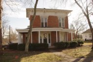
United States Department of the InteriorNational Park Service / National Register of Historic Places Registration FormNPS Form 10-900 OMB No. 1024-0018 (Expires 5/31/2012)<strong>Springfield</strong> <strong>Main</strong> <strong>Street</strong> <strong>District</strong>Name of PropertyWashington <strong>Kentucky</strong>County and Statemanufacturing buildings associated with feed and lumber operations intentionally located in closerproximity to the railway right-of-way and farther from <strong>Main</strong> <strong>Street</strong> residences.In the early 1800s, roads in <strong>Springfield</strong> were simply dirt with “foot bridges” over the areas wherewater encroached. Roads retained stumps and sink holes, leading the town founders to improve them.An 1838 act of the General Assembly ordered roads paved with flat stones or bricks. The northern sideof <strong>Main</strong> <strong>Street</strong> from Walnut <strong>Street</strong> to the public square was the first to be paved in this fashion. Originally,<strong>Springfield</strong>’s water supply came from large springs which may have given the town its name. This 1802Town Plat of <strong>Springfield</strong> shows the locations of the public well (lot #40) and public spring (lot #30); thesewere located on parcels. The town eventually outgrew these springs, updating to cisterns located along<strong>Main</strong> and Cross <strong>Main</strong> <strong>Street</strong>s. ivMost of the commercial area’s antebellum landscape has disappeared. The Washington CountyCourthouse (WSS-2; Inventory #38) is the oldest identified building within the district and encouragedfuture development centered on the node of <strong>Main</strong> and Cross <strong>Main</strong>. While the population of <strong>Springfield</strong>declined from 1830 to 1860, the business center of <strong>Springfield</strong> began to develop anyway. v The 1893Sanborn map for <strong>Springfield</strong> shows a pattern of dense, mixed-use development within the current<strong>Springfield</strong> Historic Commercial <strong>District</strong> NRHP boundaries. Two-story frame dwellings are locatedalongside brick two- and three-story commercial buildings and built on the same long, narrow urban lots;in rare cases a building may have a dual commercial residential function. Located just one block awayare much larger, more widely-spaced frame houses. The earliest churches were rebuilt in the latenineteenthcentury. For example, the Presbyterian Church of 1888 (WSS-9; Inventory #60) incorporatesa tower from its previous 1838 church. Other nineteenth-century buildings of note include the 1896Robertson’s Dry Goods - originally Robertson and McCord (WSS-22; Inventory #115), 1896 G.L. HaydonBuilding (WSS-23; Inventory #117), mid-1890s Cunningham’s Dry Goods (WSS-54; Inventory #58), andthe Louisville Store (WSS-44; Inventory #116).<strong>Main</strong> <strong>Street</strong> in <strong>Springfield</strong> historically developed in a linear fashion, dominated by a node at itsintersection with Cross <strong>Main</strong> <strong>Street</strong>. This significant intersection still serves as the dividing line betweenWest and East <strong>Main</strong>. At its northeastern corner is the Georgian, brick, Washington County Courthouse,completed in 1816 by Thomas H. Fletcher (WSS-2; Inventory #38). The courthouse cupola, althoughinstalled in 1840, has become an architectural feature synonymous with <strong>Springfield</strong>. To the northwest ofthe courthouse was the historic public square which has since been partially paved. It remains as a widerportion of North Cross <strong>Main</strong>. The courthouse is the focal point for <strong>Main</strong> <strong>Street</strong> in <strong>Springfield</strong> and wasoriginally associated with a public square, located at the widened portion of North Cross <strong>Main</strong> <strong>Street</strong>.Across the original public square were civic and professional office buildings. These included the 106North Cross <strong>Main</strong> location of the late 1870s, two story, brick Circuit and County Clerk’s Offices (WSS-106; Inventory #35); the frame, single-story office buildings at 108-110 North Cross <strong>Main</strong> (WSS-46 andWSS-47; Inventory #36 and #37); single-story, brick Progress Printing Office at 114 North Cross <strong>Main</strong>(WSS-48; Inventory #40), and single-story brick Pat Grigsby Law Office at 116 Cross <strong>Main</strong> (WSS-49;Inventory #41). An irregular boundary for the original <strong>Springfield</strong> Historic Commercial <strong>District</strong> was causedby the inclusion of the 201 Lincoln Park Road location of the William H. Hayes Law Office (WSS-32;Inventory #25), now belonging to the <strong>Springfield</strong> Woman’s Club. This building, due to its originalinclusion, is also included in the <strong>Springfield</strong> <strong>Main</strong> <strong>Street</strong> <strong>District</strong>.At the southwestern corner of the <strong>Main</strong>–Cross <strong>Main</strong> intersection is the prominent 1896 Robertson& McCord Building (WSS-22; Inventory #115). With its Romanesque Revival architecture and cornerturret, this brick commercial building commands attention. The 1875-1899 Louisville Store (WSS-44;iv Washington County History Book Committee, p. 52.v Washington County Multiple Resource Area, National Register of Historic Places Nomination Form,1988, Item #7, p. 8.5
United States Department of the InteriorNational Park Service / National Register of Historic Places Registration FormNPS Form 10-900 OMB No. 1024-0018 (Expires 5/31/2012)<strong>Springfield</strong> <strong>Main</strong> <strong>Street</strong> <strong>District</strong>Name of PropertyWashington <strong>Kentucky</strong>County and StateInventory #116), located at the northwestern corner of the intersection provides another commercialanchor.During the nineteenth century economic and building boom in <strong>Springfield</strong>, <strong>Main</strong> <strong>Street</strong>businesses were typically housed in Italianate or Romanesque Revival style brick, two-story commercialbuildings. Houses built during this period were predominantly of frame construction and often hadVictorian decorative features. In the late-nineteenth century, the population of <strong>Springfield</strong> began toexpand. Turn-of-the-century <strong>Main</strong> <strong>Street</strong> businesses tended to employ mass-produced features such asthe George Mesker storefronts and metal cornices still well represented on <strong>Main</strong> <strong>Street</strong> in <strong>Springfield</strong>.From the 1880s through the second decade of the twentieth century, Mesker’s Evansville, Indiana,company sold an estimated 5,000 manufactured facades to building owners across the country. Thesefacades could imitate the look of brick, stone, or concrete block. vi These were advertised in catalogs andcould be used to update the look of older buildings or more cheaply and easily ensure that newcommercial buildings featured current styles. They also indicated a certain level of prosperity on <strong>Main</strong><strong>Street</strong>. Twentieth-century domestic architecture in the city consisted mainly of one- and two-story T-planhouses, with American Foursquares and bungalows also being built. In the later twentieth century,buildings were updated with new materials and streamlined architectural details aimed at luring theconsumer. New buildings in the core were built on increasingly smaller lots. As land values increasedand lots subdivided, <strong>Main</strong> <strong>Street</strong> became more densely developed. The building density along <strong>Main</strong><strong>Street</strong> in the blocks near the courthouse increased into the first quarter of the twentieth century.The telephone appears to have reached <strong>Springfield</strong> when the L & N reached Lebanon - wellbefore the railroad arrived in <strong>Springfield</strong> itself. An 1883-4 Gazetteer noted the “connection by telephonewith Lebanon.” vii An 1896 Gazeteer was more specific, noting <strong>Springfield</strong>’s “W.U. telephoneconnection.” viii The original telephone exchange was housed on the second story of the brick Haydonand Robertson Drugs building (WSS-50; Inventory #52) at 111-115 East <strong>Main</strong> <strong>Street</strong>. Original telegraphlines, associated with the railroad, were removed about twenty years before the L & N Railroad tracks in<strong>Springfield</strong> were removed in 1987. ix By 1890, gas lamps had been added, replacing the older oil lampsfor street lighting. xThe <strong>Springfield</strong> Electric Light and Water Company incorporated in 1900, and the city purchasedtwenty-five hydrants and twelve 2,000-candle power arc lamps which would burn until midnight. ByDecember 1900, the local newspaper noted that most businesses had installed wires for incandescentlights and that owners of private residences were contracting for them. The new plant was in operationby January 1901. Water mains originally extended as far as Walnut <strong>Street</strong> from the western end of town;these four- to six-inch-diameter pipes appear on the 1903 Sanborn Fire Insurance map for the first time.The power house produced electricity by burning coal. xi In 1907, a fire ravaged <strong>Main</strong> <strong>Street</strong> from what isnow 125 East <strong>Main</strong> through the end of the block, destroying most of these buildings. The late-nineteenthcentury two-story Wall Building at 139 East <strong>Main</strong> (WSS-10; Inventory #61), originally frame with ironsheathing and brick veneer facade, was one of only two that survived the fire. Several of the buildingsbuilt in the early-twentieth century after that fire were themselves burned in the mid-1960s, replaced bythe <strong>Springfield</strong> State Bank (WSS-111; Inventory #56). In 1912, residents on the south side of <strong>Main</strong> <strong>Street</strong>vi Tom Wyman, “Evansville firm becomes iron giant,” Indiana Preservationist, volume 5,September/October 2005, p. 4.vii <strong>Kentucky</strong> State Gazetteer and Business Directory, vol. IV, (Louisville: R.L. Polk & Co.: 1883-4), pp.788-789.viii <strong>Kentucky</strong> State Gazetteer and Business Directory, vol. VII, (Louisville: R.L. Polk & Co.: 1896), pp. 788-789.ix Interview with Carroll Kelly by Jennifer Ryall, telephone interview, June 2011.x Washington County History Book Committee, p. 52.xi Washington County History Book Committee, p. 53.6
United States Department of the InteriorNational Park Service / National Register of Historic Places Registration FormNPS Form 10-900 OMB No. 1024-0018 (Expires 5/31/2012)<strong>Springfield</strong> <strong>Main</strong> <strong>Street</strong> <strong>District</strong>Name of PropertyWashington <strong>Kentucky</strong>County and Stateuncommon in Washington County and several identified examples in the county dated to the lateantebellumperiod. xxviiiThere is an approximately equal representation in the numbers of frame buildings of the 1875-1899 and 1925-1949 time periods. The majority of the frame houses on <strong>Main</strong> <strong>Street</strong> date to 1900-1924,when the Pettus and Kelly Lumber Companies would have been active. Both companies were locatedwithin the boundary of the <strong>Springfield</strong> <strong>Main</strong> <strong>Street</strong> <strong>District</strong>. Pettus Lumber Company, founded by JosephFranklin Pettus first as a branch yard for the Lebanon Lumber Company in 1901, was in business through1974. His son John I. Pettus joined his father in the business later. The Pettus Lumber Company hadboth lumber yards and a general contracting business. xxix The Kelly Lumber Company was organized byJohn R. Kelly in 1918. xxxAlso of note, brick veneer-sided frame buildings and structural masonry buildings are representedin approximately equal numbers within the district. Although many date to the twentieth century, theMeekes/Craycroft Saddler’s Shop (WSS-52; Inventory #55), the commercial building at 126 E. <strong>Main</strong>(WSS-112; Inventory #57), and the Wall Building (WSS-10; Inventory #61) are all brick veneer-sidedframe commercial examples with 1875-1899 periods of construction. All three are located in the 100block of East <strong>Main</strong>.MasonryMasonry buildings represented only about 8 percent of those documented in the RHDI survey.The author noted that the importance of masonry is greater than its numbers suggest “since eachstructure represents a relatively greater investment in permanence than a comparable frame building.” xxxiThe author also describes the industrialization of brick which occurred in the late-nineteenth and earlytwentiethcenturies. Brick became increasingly standardized and easier to obtain. The core of the countyseat would have been the ideal location to obtain brick to build commercial symbols of success and, thus,attract customers. The number of brick buildings in <strong>Springfield</strong> is proportionally higher than arerepresented in the county; this is not uncommon and would have helped differentiate the county seat anddefine the identity of Washington County. Structural brick was used for institutional, religious, andcommercial buildings in <strong>Springfield</strong>. Brick was introduced early in Washington County – perhaps in the1780s. xxxii Good examples include most of the late-nineteenth- and early-twentieth-century commercialbuildings in <strong>Springfield</strong> as well as the 1877-1879 Clerks’ Office (WSS-106; Inventory #35), the 1816Washington County Courthouse (WSS-2; Inventory #38), and the 1888 <strong>Springfield</strong> Presbyterian Church(WSS-9; Inventory #34). A later example is the 1903 <strong>Springfield</strong> Graded School (WSS-14; Inventory#35). A good example of a structural brick building serving a religious function in <strong>Springfield</strong> is St.Dominic’s Church (WSS-3; Inventory #152).In addition to structural brick, concrete block as a construction method is included in the RHDIsurvey report as a “fully manufactured” masonry sub-type. Concrete block is represented in several latercommercial and light industrial buildings in the <strong>Springfield</strong> <strong>Main</strong> <strong>Street</strong> <strong>District</strong>; most of these date from1925-1949. Good examples of concrete block buildings in the district are the 1927 Haydon Coal & OilCompany Building (WSS-188; Inventory #170) and the 1949 Cowden Manufacturing Company Plant(WSS-105; Inventory #33).xxviii Washington County Multiple Resource Area, Item #7, p. 8.xxix Washington County History Book Committee, p. 373.xxx Washington County History Book Committee, p. 328xxxi Macintire, p. 28.xxxii Washington County Multiple Resource Area, Item #7, continuation sheet #2.10
United States Department of the InteriorNational Park Service / National Register of Historic Places Registration FormNPS Form 10-900 OMB No. 1024-0018 (Expires 5/31/2012)<strong>Springfield</strong> <strong>Main</strong> <strong>Street</strong> <strong>District</strong>Name of PropertyWashington <strong>Kentucky</strong>County and StateINVENTORY OF DISTRICT RESOURCESKey:blank| outside original district boundaryL| outside original district boundary, listed NRHPNE| not evaluatedWP| wooden panelingNA| not applicableNC/A| non-contributing (age)NC/E| non-contributing (empty lot)NC/M| non-contributing (modification)A| aluminumB| brickBB| board & battenBV| brick veneerCC| cast concreteCS| composite sidingCB| concrete blockCM| corrugated metalF| frame (TF – timber frame)HB| horizontal boardL| logM| metalP – prefabPC| poured concreteS| stoneU – undeterminedV| vinyl sidingVB| vertical boardW| weatherboard13
United States Department of the InteriorNational Park Service / National Register of Historic Places Registration FormNPS Form 10-900 OMB No. 1024-0018 (Expires 5/31/2012)<strong>Springfield</strong> <strong>Main</strong> <strong>Street</strong> <strong>District</strong>Name of PropertyWashington <strong>Kentucky</strong>County and State17 114 S.DoctorSt.,SuitesA & B18 200 S.DoctorSt.19 S.DoctorSt.20 204 S.DoctorSt.21 206 S.DoctorSt.22 226 S.DoctorSt.23 S.DoctorSt.24 101Fairground Ln.25 201LincolnParkRd.26 105 S.LocustSt.27 S.LocustSt.28 106 S.LocustSt.29 101Mackville Hill30 103Mackville Hill31 105Mackville Hill32 107Mackville Hill33 109Mackville HillWSS-205WSS-206WSS-207WSS-208WSS-208.001WSS-210WSS-211WSS-100U CB CB no yes 1925-1949U U V no yes 1925-1949U U CM no no 1925-1949U U CM no yes 1925-1949U CB CB no no 1950-1974U U V no no 1925-1949Bridge OverRoad RunCreekM & JConstructionWSS-32 William H.Hayes LawOfficeWSS-212WSS-213WSS-214WSS-101WSS-102WSS-103WSS-104WSS-105NA NA no no 1955 NA CBV BV no no 2001 BV NC/AB B yes yes 1850-1874U U V yes yes 1875-1899PinkyThompson’sWelding ShopU CM no yes 1925-1949U U V no yes 1925-1949U U V yes yes 1900-1924U U V yes yes 1900-1924U U V no yes 1900-1924U U V no yes 1900-1924CowdenManufacturingCompanyPlantCBFFFCBFCCCCCCB C CCB CB yes no 1949 CB CFFFFFFFCCCCCNC/MC15
United States Department of the InteriorNational Park Service / National Register of Historic Places Registration FormNPS Form 10-900 OMB No. 1024-0018 (Expires 5/31/2012)<strong>Springfield</strong> <strong>Main</strong> <strong>Street</strong> <strong>District</strong>Name of PropertyWashington <strong>Kentucky</strong>County and State34 120Mackville Hill35 106 N.Cross<strong>Main</strong>St.36 108 N.Cross<strong>Main</strong>St.37 110 N.Cross<strong>Main</strong>St.38 111 N.Cross<strong>Main</strong>St.39 112 N.Cross<strong>Main</strong>St.40 114 N.Cross<strong>Main</strong>St.41 116 N.Cross<strong>Main</strong>St.42 117 N.Cross<strong>Main</strong>St.43 100 S.Cross<strong>Main</strong>St.44 100 S.Cross<strong>Main</strong>St.45 112 S.Cross<strong>Main</strong>St.46 116-120 S.Cross<strong>Main</strong>St.WSS-14WSS-106<strong>Springfield</strong>GradedSchoolClerks’ Office B B no yes 1875-1899B B no yes 1903 B L CWSS-46 U W V no yes 1875-1899WSS-47 U W V no yes 1875-1899WSS-2WSS-107WSS-48WSS-49WSS-108WSS-215WSS-216WSS-217WSS-218WashingtonCo.CourthouseB B yes no 1814-1816Polin Building BV BV no no 1950-1974ProgressPrinting OfficePat GrigsbyLaw OfficeB B yes yes 1875-1899B B no yes 1875-1899U BV BV yes yes 1900-1924U B B yes yes 1875-1899U B B yes no 1875-1899U U CS no yes 1925-1949G.L.H.BuildingB C(as pt.ofLvilleStore)CF C NC/MF C NC/MB C CBV NC CB C CB C CBVBBC (w/oownsite #)B B no yes 1939 B CFCCCNC/M16
United States Department of the InteriorNational Park Service / National Register of Historic Places Registration FormNPS Form 10-900 OMB No. 1024-0018 (Expires 5/31/2012)<strong>Springfield</strong> <strong>Main</strong> <strong>Street</strong> <strong>District</strong>Name of PropertyWashington <strong>Kentucky</strong>County and State47 200 S.Cross<strong>Main</strong>St.48 S.Cross<strong>Main</strong>St.49 206 S.Cross<strong>Main</strong>50 207 S.Cross<strong>Main</strong>51 100 E.<strong>Main</strong>St.52 111-115 E.<strong>Main</strong>St.53 117 E.<strong>Main</strong>St.54 120-124 E.<strong>Main</strong>St.55 121 E.<strong>Main</strong>St.56 125 E.<strong>Main</strong>St.57 126 E.<strong>Main</strong>St.58 128 E.<strong>Main</strong>St.59 135 E.<strong>Main</strong>St.60 138 E.<strong>Main</strong>St.61 139 E.<strong>Main</strong>St.62 140 E.<strong>Main</strong>St.63 140 E.<strong>Main</strong>St.WSS-219WSS-222WSS-220WSS-221WSS-110WSS-50WSS-51WSS-55WSS-52WSS-111WSS-112WSS-54U CB CB no yes 1925-1949Bridge OverRoad RunCreekWash. Co.Senior CenterNA NA no no 1923 NA CBV BV NA NA 1975-2000Taylor Tire CB CM yes no 1900-1924WashingtonCo. JudicialCenterHaydon &RobertsonDrugsMcCord andRobertsonStoreLeo HaydonDrugsMeekes/Craycroft Saddler’sShop<strong>Springfield</strong>State BankCBBVCBCNC/ABV BV NA NA 2009 BV NE NC/AB B yes yes 1850-1874B B no yes 1850-1874B B no yes 1875-1899BV BV no yes 1875-1899BV BV NA NA 1968-1969U BV BV yes yes 1875-1899Cunningham’sDry GoodsB B no yes 1893-1895WSS-53 U B BV yes yes 1900-1924CB C CB C CB C CBV C CBV NC NC/ABV NC CB C CB C CWSS-9 <strong>Springfield</strong>PresbyterianCh.B B yes no 1888 B C CWSS-10 Wall Building BV BV yes yes 1875- BV C C1899WSS-30WSS-194McClure &MayesBuildingB B no yes 1910-1916B C CEmpty Lot NA NA no yes NA NA NE NC/E17
United States Department of the InteriorNational Park Service / National Register of Historic Places Registration FormNPS Form 10-900 OMB No. 1024-0018 (Expires 5/31/2012)<strong>Springfield</strong> <strong>Main</strong> <strong>Street</strong> <strong>District</strong>Name of PropertyWashington <strong>Kentucky</strong>County and State64 145 E.<strong>Main</strong>St.65 145 E.<strong>Main</strong>St.66 145 E.<strong>Main</strong>St.67 201 E.<strong>Main</strong>St.68 201 E.<strong>Main</strong>St.69 202 E.<strong>Main</strong>St.70 206 E.<strong>Main</strong>St.71 206 E.<strong>Main</strong>St.72 210 E.<strong>Main</strong>St.73 216 E.<strong>Main</strong>St.74 221 E.<strong>Main</strong>St.75 225 E.<strong>Main</strong>St.76 226 E.<strong>Main</strong>St.77 226 E.<strong>Main</strong>St. – R78 233 E.<strong>Main</strong>St.79 301 E.<strong>Main</strong>St.80 302 E.<strong>Main</strong>St.81 306 E.<strong>Main</strong>St.WSS-113WSS-109WSS-196WSS-13WSS-114WSS-37WSS-115WSS-115.001WSS-116WSS-57WSS-58WSS-117WSS-118WSS-223WSS-119WSS-120WSS-121WSS-122Simms ShellStationBV BV NA NA 1950-1974BVNC/AEmpty Lot NA NA no yes N/A NA NC/EEmpty Lot NA NA no yes N/A NA NC/E<strong>Springfield</strong>ChristianChurchB B yes no 1900 B CEmpty Lot NA NA no yes NA NA NC/EU.S. PostOffice –<strong>Springfield</strong>DX GasStationB B no yes 1939 B CCB CB no yes 1950-1974Garage 1925-1949Wash Co.Public LibraryGeorgeDudleyRobertsonHomeHale-Polin-RobinsonCBCBNC/MBV BV NA NA 1965 BV NC/ACB CB no no 1879 TF CW V no yes 1893 F CU W W yes no 1875-1899Bell SouthBuildingBV BV no yes 1950-1974U CB CB NA NA 1975-2000FBVCBCCCNC/AEmpty Lot NA NA yes yes NA NA NC/EU U BV no yes 1900-1924F/BVWashingtonCounty HealthCenterBV BV NA NA 1976 BV NC/AU U V yes yes 1875- FC1899C18
United States Department of the InteriorNational Park Service / National Register of Historic Places Registration FormNPS Form 10-900 OMB No. 1024-0018 (Expires 5/31/2012)<strong>Springfield</strong> <strong>Main</strong> <strong>Street</strong> <strong>District</strong>Name of PropertyWashington <strong>Kentucky</strong>County and State82 308 E.<strong>Main</strong>St.83 309 E.<strong>Main</strong>St.84 309 E.<strong>Main</strong>St.85 310 E.<strong>Main</strong>St.86 311 E.<strong>Main</strong>St.87 312 E.<strong>Main</strong>St.88 314 E.<strong>Main</strong>St.89 315 E.<strong>Main</strong>St.90 319 E.<strong>Main</strong>St.91 323 E.<strong>Main</strong>St.92 324 E.<strong>Main</strong>St.93 324 E.<strong>Main</strong>St.94 325 E.<strong>Main</strong>St.95 327 E.<strong>Main</strong>St.96 328 E.<strong>Main</strong>St.97 329 E.<strong>Main</strong>St.98 329 E.<strong>Main</strong>St.WSS-123WSS-25WSS-25.001WSS-124WSS-125WSS-126WSS-7WSS-127WSS-128WSS-129WSS-130WSS-209WSS-131WSS-132WSS-133WSS-134WSS-134.001U U V yes yes 1875-1899MethodistEpiscopalChurch SouthMethodistEpiscopalChurch SouthB B yes no 1911 B CU V no yes 1900-1924RectoryU U BV yes yes 1925-1949U U V yes yes 1900-1924U U A no yes 1900-1924William PlattHs.YeagerApartmentsW W yes yes 1825-1849U V yes yes 1875-1899U BV BV NA NA 1950-1974U U A yes yes 1900-1924Reed’sFoodlandFFFFFLFBVFCCCNC/MNC/MCCNC/ACM CM NA NA 1993 F NC/AEmpty Lot NA NA yes yes NA NA NC/EWilliam D. &Ella CraycroftMcElroyHouseW W yes yes 1900-1924U U V yes yes 1875-1899U U V no yes 1900-1924HaydonDuplexHaydonDuplex Unit #2FFFCCNC/MV V NA NA 2000 F NC/AV V NA NA 2000 F NC/AC19
United States Department of the InteriorNational Park Service / National Register of Historic Places Registration FormNPS Form 10-900 OMB No. 1024-0018 (Expires 5/31/2012)<strong>Springfield</strong> <strong>Main</strong> <strong>Street</strong> <strong>District</strong>Name of PropertyWashington <strong>Kentucky</strong>County and State99 333 E.<strong>Main</strong>St.100 402 E.<strong>Main</strong>St.101 405 E.<strong>Main</strong>St.102 406 E.<strong>Main</strong>St.103 408 E.<strong>Main</strong>St.104 409 E.<strong>Main</strong>St.105 410 E.<strong>Main</strong>St.106 411 E.<strong>Main</strong>St.107 412 E.<strong>Main</strong>St.108 413 E.<strong>Main</strong>St.109 415 E.<strong>Main</strong>St.110 417 E.<strong>Main</strong>St.111 418 E.<strong>Main</strong>St.112 419 E.<strong>Main</strong>St.113 420 E.<strong>Main</strong>St.114 422 E.<strong>Main</strong>St.115 100 W.<strong>Main</strong>St.116 101 W.<strong>Main</strong>St.WSS-19WSS-135WSS-136WSS-228WSS-137WSS-138WSS-139WSS-140WSS-141WSS-142WSS-143WSS-144WSS-145WSS-146WSS-147WSS-148WSS-22WSS-44CovingtonInst. Teacher’sResidenceW W yes no 1884 F L CU U V yes yes 1900- FC1924U BV BV yes yes 1900-1924El-Mar Motel S S no no 1950-1974U U V yes yes 1900-1924U U A yes yes 1900-1924U U V yes yes 1925-1949U U V no yes 1900-1924U U V yes yes 1900-1924U W W yes no 1900-1924U U V yes yes 1900-1924U U V no yes 1900-1924U W W no yes 1900-1924U U A yes yes 1900-1924U U V no yes 1900-1924U W W yes yes 1900-1924Robertson &McCordBuildingLouisvilleStoreB B yes no 1896 B C CB B yes yes 1875-1899BVFFFFFFFFFFFFFCCCCCNC/MNC/MCNC/MCCCCCB C C20
United States Department of the InteriorNational Park Service / National Register of Historic Places Registration FormNPS Form 10-900 OMB No. 1024-0018 (Expires 5/31/2012)<strong>Springfield</strong> <strong>Main</strong> <strong>Street</strong> <strong>District</strong>Name of PropertyWashington <strong>Kentucky</strong>County and State117 102-104 W.<strong>Main</strong>St.118 103 W.<strong>Main</strong>St.119 105 W.<strong>Main</strong>St.120 106 W.<strong>Main</strong>St.121 108-114 W.<strong>Main</strong>St.122 116-122 W.<strong>Main</strong>St.123 117 W.<strong>Main</strong>St.124 123 W.<strong>Main</strong>St.125 124 W.<strong>Main</strong>St.126 126 W.<strong>Main</strong>St.127 127 W.<strong>Main</strong>St.128 127 W.<strong>Main</strong>St. - R129 128-132 W.<strong>Main</strong>St.130 133 W.<strong>Main</strong>St.131 137 W.<strong>Main</strong>St.132 138 W.<strong>Main</strong>St.WSS-23WSS-149WSS-61WSS-36G.L. HaydonBuildingB B no yes 1896 B C CKelly’s Drugs BV BV NA NA 1950-1974David BottomChevroletWashingtonBank BuildingB B no yes 1900-1924BV NC NC/AB C CB B yes yes 1860s B C CWSS-41 U B B yes yes 1875-1899WSS-38WSS-150WSS-151<strong>Springfield</strong>MasonicLodgeBuildingCecconi’sRestaurantB B yes no 1900-1924U V yes yes 1875-1899U BV BV yes yes 1900-1924B C CB C CF NC CBVWSS-12 Opera House B B no yes 1900 B C CC(w/dupl.site #WSS-32)WSS-152WSS-153WSS-202WSS-154WSS-40WSS-155WSS-21Joe MayesBarber Shop<strong>Springfield</strong>City HallBV BV no yes 1950-1974CU NC CBV BV NA NA 1983 BV NC NC/AU B B no yes 1925-1949U U U no yes 1925-1949E.H. CampbellBuildingB NE CU NC CB B no yes 1926 B C CU BV BV NA NA 1975-2000Barber/RiceHouseB BV yes yes 1875-1899BVB C CNC/A21
United States Department of the InteriorNational Park Service / National Register of Historic Places Registration FormNPS Form 10-900 OMB No. 1024-0018 (Expires 5/31/2012)<strong>Springfield</strong> <strong>Main</strong> <strong>Street</strong> <strong>District</strong>Name of PropertyWashington <strong>Kentucky</strong>County and State133 138 W.<strong>Main</strong>St.134 144 W.<strong>Main</strong>St.135 146 W.<strong>Main</strong>St.136 200 W.<strong>Main</strong>St.137 201 W.<strong>Main</strong>St.138 208 W.<strong>Main</strong>St.139 209 W.<strong>Main</strong>St.140 213 W.<strong>Main</strong>St.141 219 W.<strong>Main</strong>St.142 220 W.<strong>Main</strong>St.143 223 W.<strong>Main</strong>St.144 226 W.<strong>Main</strong>St.145 227 W.<strong>Main</strong>St.146 228 W.<strong>Main</strong>St.147 229 W.<strong>Main</strong>St.148 231 W.<strong>Main</strong>St.149 300 W.<strong>Main</strong>St.150 301 W.<strong>Main</strong>St.WSS-42WSS-156L.A. BurnsBuildingB B yes yes 1900-1924U B CB yes yes 1925-1949WSS-39 U W W yes yes 1875-1899WSS-157WSS-158WSS-159WSS-160WSS-161WSS-162WSS-163WSS-164WSS-165WSS-166WSS-167WSS-168WSS-169WSS-170WSS-171B C CB C CF C NC/MU WP WP NA NA 1984 BV NC NC/APontiacGarageCB CM yes yes 1950-1974U BV BV NA NA 1980s BV NC/AMilburn ShoeShopCB CB yes no 1950-1974U U BV yes yes 1875-1899<strong>Springfield</strong>MedicalAssociatesBV BV no yes 1955 BV CU U V yes yes 1925- FC1949Mary HamiltonHouseU V no no 1925-1949U U BV yes yes 1900-1924U U V yes yes 1900-1924CBCBFFBVFCCNC/MU U CM NA NA 1997 U NC/AU BV BV no yes 1925-1949PurdomHouseU V yes yes 1900-1924U U V yes yes 1875-1899U U V no yes 1925-1949BVFFFCCCCCCC22
United States Department of the InteriorNational Park Service / National Register of Historic Places Registration FormNPS Form 10-900 OMB No. 1024-0018 (Expires 5/31/2012)<strong>Springfield</strong> <strong>Main</strong> <strong>Street</strong> <strong>District</strong>Name of PropertyWashington <strong>Kentucky</strong>County and State151 302 W.<strong>Main</strong>St.152 305 W.<strong>Main</strong>St.153 303 W.<strong>Main</strong>St.154 309 W.<strong>Main</strong>St.155 304 W.<strong>Main</strong>St.156 306 W.<strong>Main</strong>St.157 308 W.<strong>Main</strong>St.158 310 W.<strong>Main</strong>St.159 312 W.<strong>Main</strong>St.160 314 W.<strong>Main</strong>St.161 317 W.<strong>Main</strong>St.162 320 W.<strong>Main</strong>St.163 321 W.<strong>Main</strong>St.164 323 W.<strong>Main</strong>St.165 324 W.<strong>Main</strong>St.166 325 W.<strong>Main</strong>St.167 326 W.<strong>Main</strong>St.WSS-172WSS-3WSS-3.001WSS-3.003WSS-173WSS-174WSS-175WSS-176WSS-177WSS-178WSS-179WSS-180WSS-181WSS-182WSS-183WSS-184WSS-185U U V no yes 1900-1924St. Dominic’sChurchSt. Dominic’sRectorySt. Dominic’sSchoolB B no no 1890-1894U V yes yes 1900-1924BV BV yes yes 1928-1929U U V yes yes 1900-1924Frank andLouiseHamiltonHouseU V no yes 1925-1949FCB L CU U V no yes 1935 F CHamiltonBarber HouseClell BoblittHouseU V no yes 1925-1949U V no no 1925-1949U W A no no 1900-1924U W W no yes 1875-1899<strong>Springfield</strong>ApartmentsBV BV NA NA 1960s BV NC/AU U V yes yes 1900-1924U U V no yes 1875-1899Leon F. andDelina SimmsHouseBV BV no no 1925-1949U U V yes yes 1875-1899Tom andKathleenWheatleyHouseBV BV no no 1925-1949FBVFFFFFFFFBVFBVCCCCCCCCCCCCC23
United States Department of the InteriorNational Park Service / National Register of Historic Places Registration FormNPS Form 10-900 OMB No. 1024-0018 (Expires 5/31/2012)<strong>Springfield</strong> <strong>Main</strong> <strong>Street</strong> <strong>District</strong>Name of PropertyWashington <strong>Kentucky</strong>County and State168 327 W.<strong>Main</strong>St.169 332 W.<strong>Main</strong>St.170 334 W.<strong>Main</strong>St.171 401 W.<strong>Main</strong>St.172 403 W.<strong>Main</strong>St.173 403 W.<strong>Main</strong>St.174 405 W.<strong>Main</strong>St.175 407 W.<strong>Main</strong>St.176 501 W.<strong>Main</strong>St.177 503 W.<strong>Main</strong>St.178 110 S.Walnut179 114-118 S.Walnut180 S.WalnutWSS-186WSS-188.005WSS-188WSS-189WSS-190WSS-187WSS-191WSS-192WSS-193WSS-195WSS-224WSS-225WSS-227U U V yes yes 1925-1949Haydon Coal& Oil TireRetreadBuildingHaydon Coal& Oil<strong>Springfield</strong>Wrhs. of theBurleyTobaccoGrwrs. Co-Op.Wrhsng. Assn.No. 95CB CB no yes 1950-1974CB CB yes yes 1927 CB CU CM no yes 1900-1924U U V yes yes 1875-1899HistoricallyEmpty LotNA NA yes yes NA NA NC/MU U V yes yes 1900-1924U BV BV no yes 1950-1974U U V no yes 1900-1924U U V yes yes 1900-1924U CB CB no yes 1950-1974U CB CB no yes 1950-1974Bridge overRoad RunNA NA no no 1900-1924FFFFFBVFFCBCBNACCCCCCCCCNC/MC24
United States Department of the InteriorNational Park Service / National Register of Historic Places Registration FormNPS Form 10-900 OMB No. 1024-0018 (Expires 5/31/2012)<strong>Springfield</strong> <strong>Main</strong> <strong>Street</strong> <strong>District</strong>Name of PropertyWashington <strong>Kentucky</strong>County and StateOutbuilding Inventory<strong>Street</strong>Add.181 E. BallardSt.182 E. BallardSt.183 232 E.Ballard184 201LincolnPark Rd.185 101MackvilleHill Rd.186 103MackvilleHill Rd.187 105MackvilleHill Rd.188 107MackvilleHill Rd.189 120MackvilleHill Rd.190 120MackvilleHill Rd.191 111 N.Cross <strong>Main</strong>St.192 111 N.Cross <strong>Main</strong>St.193 226 E.<strong>Main</strong> St. -R194 226 E.<strong>Main</strong> St. –R195 301 E.<strong>Main</strong> St.196 310 E.<strong>Main</strong> St.197 311 E.<strong>Main</strong> St.198 314 E.<strong>Main</strong> St.199 314 E.<strong>Main</strong> St.Site # Descrip. Orig.Exter.Mat.WSS-226.001WSS-226.002WSS-98.001WSS-32.001WSS-101.001WSS-102.001WSS-103.001WSS-104.001WSS-14.001WSS-14.002WSS-2.001WSS-2.002WSS-223.001WSS-223.002WSS-120.001WSS-124.001WSS-125.001WSS-7.001WSS-7.002Crrnt.Exter.Mat.Signif.Altn.DuringP.O.S.Signif.Altn.AfterP.O.S.Est.Date ofConstr.Const.Mthd.1989Nom.Status2011StatusU U A U U U F NC/MU U CM U U 2001-presentFNC/AU M M NA NA 1975- PNC/A2000U U CM U U U F NE CU U CM U U U F CU U CM U U U F CU U V U U U F CU U U NA NA U U NC/AU NA NA U U 1900-1924U NA NA U U U U CU NA NA U U 1900-1924PC25CS NE CU NA NA U U U CC NE CU NA NA NA NA 1975-2000U U U NA NA 1975-2000MUNC/ANC/AU CB CB U U 1950-1974CBCU U A U U 1925- FC1949U V V NA NA 2001- FNC/ApresentU NA NA U U U NA CU U CS U U 1900-1924FC
United States Department of the InteriorNational Park Service / National Register of Historic Places Registration FormNPS Form 10-900 OMB No. 1024-0018 (Expires 5/31/2012)<strong>Springfield</strong> <strong>Main</strong> <strong>Street</strong> <strong>District</strong>Name of PropertyWashington <strong>Kentucky</strong>County and State200 314 E.<strong>Main</strong> St.201 325 E.<strong>Main</strong> St.202 325 E.<strong>Main</strong> St.203 333 E.<strong>Main</strong> St.204 333 E.<strong>Main</strong> St.205 405 E.<strong>Main</strong> St.206 406 E.<strong>Main</strong> St.207 409 E.<strong>Main</strong> St.208 412 E.<strong>Main</strong> St.209 413 E.<strong>Main</strong> St.210 418 E.<strong>Main</strong> St.211 418 E.<strong>Main</strong> St.212 419 E.<strong>Main</strong> St.213 420 E.<strong>Main</strong> St.214 213 W.<strong>Main</strong> St.215 220 W.<strong>Main</strong> St.216 220 W.<strong>Main</strong> St.217 227 W.<strong>Main</strong> St.218 227 W.<strong>Main</strong> St.219 227 W.<strong>Main</strong> St.220 229 W.<strong>Main</strong> St.221 229 W.<strong>Main</strong> St.222 231 W.<strong>Main</strong> St.223 300 W.<strong>Main</strong> St.224 317 W.<strong>Main</strong> St.225 321 W.<strong>Main</strong> St.226 325 W.<strong>Main</strong> St.WSS-7.003WSS-131.001WSS-131.002WSS-19.001WSS-19.002WSS-136.001WSS-228.001WSS-138.001WSS-141.001WSS-142.001WSS-145.001WSS-145.002WSS-146.001WSS-147.001WSS-161.001WSS-163.001WSS-163.002WSS-166.001WSS-166.002WSS-166.003WSS-168.001WSS-168.002WSS-169.001WSS-170.001WSS-179.001WSS-181.001WSS-184.001U U WP NA NA U F NC/AU HB HB U U 1900-1924FCU CB CB NA NA 1950- CBNC/A1974U NA NA U U U NA CU U V NA NA 2001- FNC/ApresentU NA NA U U U MS CU NA NA U U 1950- MC1974U VB VB U U U F CU CB CB U U 1950- CBC1974U U U U U U F CU U CM U U 1900-1924FNC/AU VB VB NA NA 1900- FC1924U U CM NA NA U F NC/AU U CB NA NA 1950-1974CBNC/AU U CM U U 1925- FC1949U U CM NA NA 2001- FNC/ApresentU VB VB U U 1925- FC1949U BB BB U U U F NC/MU HB HB U U U F CU BB BB U U U F NC/MU NA NA U U U NA CU U V U U 1925- FC1949U NA NA U U U NA CU M M U U 1950-1974U V V U U 2001-presentU V V U U 2001-presentU U V U U 1925-1949MFFF26NC/ANC/ANC/ANC/M
United States Department of the InteriorNational Park Service / National Register of Historic Places Registration FormNPS Form 10-900 OMB No. 1024-0018 (Expires 5/31/2012)<strong>Springfield</strong> <strong>Main</strong> <strong>Street</strong> <strong>District</strong>Name of PropertyWashington <strong>Kentucky</strong>County and State227 326 W.<strong>Main</strong> St.228 326 W.<strong>Main</strong> St.229 327 W.<strong>Main</strong> St.230 334 W.<strong>Main</strong> St.231 334 W.<strong>Main</strong> St.232 334 W.<strong>Main</strong> St.233 334 W.<strong>Main</strong> St.234 401 W.<strong>Main</strong> St.235 403 W.<strong>Main</strong> St.236 405 W.<strong>Main</strong> St.237 405 W.<strong>Main</strong> St.238 501 W.<strong>Main</strong> St.WSS-185.001WSS-185.002WSS-186.001WSS-188.001WSS-188.002WSS-188.003WSS-188.004WSS-189.001WSS-190.001WSS-191.001WSS-191.002WSS-193.001U U U U U U F CU BV BV U U 1950- BVC1974U BV BV U U 1925- BVC1949U U CM U U 1925- FC1949U U CM U U 1925- FC1949U U CM U U 1925- FC1949U U CM U U 1925- FC1949U U CM NA NA 1950- FNC/A1974U BB BB U U U F CU VB VB U U 1900- FC1924U V V U U 1900- FC1924U VB V U U U F C27
United States Department of the InteriorNational Park Service / National Register of Historic Places Registration FormNPS Form 10-900 OMB No. 1024-0018 (Expires 5/31/2012)<strong>Springfield</strong> <strong>Main</strong> <strong>Street</strong> <strong>District</strong>Name of PropertyWashington <strong>Kentucky</strong>County and State8. Statement of SignificanceApplicable National Register Criteria(Mark "x" in one or more boxes for the criteria qualifying the propertyfor National Register listing.)XABProperty is associated with events that have made asignificant contribution to the broad patterns of ourhistory.Property is associated with the lives of personssignificant in our past.Areas of Significance(Enter categories from instructions.)COMMUNITY PLANNING AND DEVELOPMENTCProperty embodies the distinctive characteristicsof a type, period, or method of construction orrepresents the work of a master, or possesses highartistic values, or represents a significantand distinguishable entity whose components lackindividual distinction.Period of Significance1816-1961DProperty has yielded, or is likely to yield, informationimportant in prehistory or history.Criteria Considerations(Mark "x" in all the boxes that apply.)Property is:AOwned by a religious institution or used for religiouspurposes.Significant Dates1816 – courthouse constructed1888 – railroad arrives1896 – Robertson & McCord Building1907 – fire on East <strong>Main</strong>Significant Person(Complete only if Criterion B is marked above.)NABCDEFGremoved from its original location.a birthplace or grave.a cemetery.a reconstructed building, object, or structure.a commemorative property.less than 50 years old or achieving significancewithin the past 50 years.Cultural AffiliationNAArchitect/BuilderFrank Brewer, architectThomas H. Fletcher, builderJohn Barber, builderPeriod of Significance (justification)The period of significance for the <strong>Springfield</strong> <strong>Main</strong> <strong>Street</strong> <strong>District</strong> begins in 1816, with the completion of the countycourthouse (WSS-2), and ends at the conventional point, 50 years prior to the listing date. The district and communitycontinue to be the most important planning, development, and commercial entities in Washington County, <strong>Kentucky</strong>,through the present.Criteria Considerations (explanation, if necessary): NA28
United States Department of the InteriorNational Park Service / National Register of Historic Places Registration FormNPS Form 10-900 OMB No. 1024-0018 (Expires 5/31/2012)<strong>Springfield</strong> <strong>Main</strong> <strong>Street</strong> <strong>District</strong>Name of PropertyWashington <strong>Kentucky</strong>County and StateStatement of Significance Summary ParagraphThe <strong>Springfield</strong> <strong>Main</strong> <strong>Street</strong> <strong>District</strong> meets National Register Criterion A for its associations with events that havemade contributions to broad patterns of local history. The district’s significance is evaluated within the context,“Community Planning and Development in Washington County, <strong>Kentucky</strong>, 1816-1961.” This nomination proposesexpansion of the area listed on the National Register as the <strong>Springfield</strong> Historic Commercial <strong>District</strong> (1989, NR ID88003434). The current nomination will draw heavily upon the commercial activity that resulted from planning anddevelopment decisions and it expands that focus to include residential and institutional uses of land as well – indeedencompassing activity of the entire town into the consideration. Two distinct periods of town planning and growthoccurred on either side of the town’s main development event, the arrival of the Louisville and Nashville Railroad in 1888.Though a small community, <strong>Springfield</strong>’s efforts to urbanize and distinguish itself from similarly-sized Washington Countytowns and villages are understood through the buildings in this historic district. These comparisons show thatKentuckians were well aware of national development trends, and when conditions presented themselves, opportunisticcitizens worked together to erect a community more complex than its small size might suggest._______________________________________________________________________________________________________________________Narrative Statement of Significance (Provide at least one paragraph for each area of significance.)Historic Context: Community Planning and Development in Washington County, <strong>Kentucky</strong>, 1816-1961:The spot that became <strong>Springfield</strong> was located along the Wilderness Trace, the road connecting Bardstown andDanville, which supported its initial settlement. This road appears on the 1784 Filson map of the area, running alongCartwright Creek and entering Washington County where Cartwright emptied into the Beech Fork. From here, it followedthe creek for several miles, branching off along Road Run in the area which would become <strong>Springfield</strong>. From there itextended toward Danville. xxxiii In 1785, this portion of the road between Danville and Bardstown was developed forwagons and named “The Big Road.” Such improvements provided early development opportunities for people coming to<strong>Kentucky</strong> at that time – land speculators, veterans of the Revolutionary War with land grants, people disadvantaged byprimogeniture, and others looking for a fresh start. Counties and towns along the Wilderness Road are some of theoldest and most heavily populated in an area that had been wilderness just a decade before.Additionally, development was encouraged by the sizable Salt River system in Washington County which led westto Ohio and south to New Orleans. Early Washington County stations, including 1776 Sandusky Station located onPleasant Run and 1779 Cartwright’s Station (about halfway between <strong>Springfield</strong> and Lebanon) located on CartwrightCreek, were established near Salt River tributaries. The Beech and Rolling Forks of the Salt River were then navigableand were used to transport goods to market. xxxiv The Salt River encouraged not only early settlement but also latershipping, excellent water supply and power. When shipping by water was not a possibility, livestock was driven overroads. Taverns, meeting houses, courthouses, and schools developed in this pioneer period of development. Manybuildings were multi-purpose and initially-large urban house lots also contained work buildings. Sales were conductedfrom the home or the shop before an actual downtown emerged. Located near what later became <strong>Springfield</strong>, on or nearWest <strong>Main</strong> <strong>Street</strong>, was the 1785 tavern of Elizabeth Grundy. Grundy was issued a deed for town lots 3, 4, and 5 when<strong>Springfield</strong> was first platted in 1795. xxxvIn the 1780s Matthew Walton, a Revolutionary War veteran who attained the rank of general, became the largestlandowner in Washington County, amassing thousands of acres under a surveying license from the Commonwealth ofVirginia. In 1784 Walton settled on Cartwright Creek on a large holding west of <strong>Springfield</strong>. xxxvi Walton was later electedas Nelson County representative to the Virginia Legislature and Nelson County delegate to the 1792 ConstitutionalConvention in Danville. As a member of the new <strong>Kentucky</strong> General Assembly, Walton introduced the bill creating400,000-acre Washington County from a portion of Nelson. xxxviixxxiii Washington County Multiple Resource Area, National Register of Historic Places nomination form, NR ID 64000261,listed 1989, section 7, continuation sheet # 17.xxxiv Orval W. Baylor, Early Times in Washington County, (Cynthiana: The Hobson Press: 1942), p. 68.xxxv Washington County History Book Committee, Washington County, <strong>Kentucky</strong> Bicentennial History, 1792-1992, (TurnerPublishing Company: 1991), p. 9.xxxvi Washington County Multiple Resource Area, section 7.xxxvii Baylor, p. 9.29
United States Department of the InteriorNational Park Service / National Register of Historic Places Registration FormNPS Form 10-900 OMB No. 1024-0018 (Expires 5/31/2012)<strong>Springfield</strong> <strong>Main</strong> <strong>Street</strong> <strong>District</strong>Name of PropertyWashington <strong>Kentucky</strong>County and StateThe community which would become <strong>Springfield</strong> had tapped its transportation advantage to become a crossroadscommunity lying near the center of the county with its original boundaries. It was <strong>Springfield</strong>’s central location whichmade it the site of the county courthouse in 1793. By 1800 the population of Washington County had already grown toover 9,000. xxxviii The decade from 1800-1810 was prosperous for <strong>Springfield</strong> and Washington County. Desirable land hadbeen claimed or bought. Local products were shipped to southern markets and merchants and manufacturingbusinesses flourished. A building representative of this period but outside the boundaries of <strong>Springfield</strong> <strong>Main</strong> <strong>Street</strong><strong>District</strong> is the house at 301 North Walnut <strong>Street</strong>. The house is within the Walnut <strong>Street</strong> Historic <strong>District</strong> and theboundaries of early <strong>Springfield</strong>. This log house was built in 1800 by John Thompson and operated as the JohnBainbridge tavern from 1817-1830. The house was later owned by well-known silversmith David H. Spears and, evenlater, by James P. Calhoun. This house remains the oldest extant house identified in <strong>Springfield</strong>. xxxix The next decadebrought setbacks - the War of 1812 discouraged building and the courthouse burned in 1814. xlAs the county’s fortunes increased, citizens further from <strong>Springfield</strong> campaigned for greater control over localaffairs. By 1820, Washington County was the third most populous behind Fayette County. There were 1,026 WashingtonCounty land owners, each owning approximately 419 acres. xli In 1827, Anderson County was created from northernportions of Washington County. When Marion County was carved from its southern half in 1834, the population ofWashington County decreased once again, but <strong>Springfield</strong>’s commerce was still expanding. Into the 1830s MatthewWalton remained the largest landowner in Washington County.By March 1850 the L & N Railroad had reached Lebanon in adjacent Marion County by way of southern NelsonCounty. xlii In 1857 came a challenge from the northern portion of the county. A bill was introduced in Frankfort to submitthe question of whether the county seat should be centrally relocated closer to Willisburg. In 1858 the governor signed abill calling for a referendum. The county judge was ordered to open a poll on the issue at the August election. W.E. Bellwas appointed as surveyor to run a line to determine the new central location for a court house if the bill passed. xliii A votewas taken and resulted in 679 in favor and 840 against. The bill was defeated. xliv According to a state vital statisticssurvey report from 1859-1860, Washington County was the fourth largest and was the location of twenty-nine stores.Washington County experienced hardships during the Civil War caused by the burning of its bridges and from propertyconfiscations by both the Union and Confederate forces. A setback for its economy was caused by the loss of southernmarkets for several years following the war. xlvBy 1890 Washington County had 253 miles of toll roads. Less than twenty <strong>Kentucky</strong> counties at that time hadsuch a well-developed toll road system. xlvi By the time an 1896 News-Leader article about the <strong>Kentucky</strong> toll gate raidswas written, Washington County was described as having “almost as many miles of turnpikes as any other in the state.”Eight pikes, each seven to fifteen miles in length, radiated out from <strong>Springfield</strong>. Others wound around the hills and valleysbetween the “twenty-five smaller towns within the borders of the county.” The beginnings of the toll gate wars occurred inWashington County. xlvii These pikes were supplemented and fed by county roads which existed through the turnpike era.In the early-twentieth century, farmers that had originally sold tobacco in Louisville or to the American TobaccoCompany began organizing into local county units of the <strong>Kentucky</strong> Union of the American Society for Equity. Farmerspooled their tobacco instead of selling it, and those farmers refusing to join the pool were threatened. Businesses in<strong>Springfield</strong> declined as farmers were without money to buy their goods. A compromise was made where farmers wouldbe able to sell tobacco to the highest bidder at the new Washington County Warehouse Company Warehouse. Poolingxxxviii Washington County Multiple Resource Area, section 7, continuation sheet #2.xxxix <strong>Springfield</strong> Tourism Commission, “Footprints to the Park,” Historical Walking Tour and Arboretum.xl Washington County History Book Committee, pp. 18-19.xli Washington County History Book Committee, p. 21.xlii Washington County History Book Committee, p. 23.xliii Washington County History Book Committee, p. 34.xliv Baylor, p. 111.xlv Washington County History Book Committee, pp. 35-37.xlvi Washington County History Book Committee, p. 51.xlvii “Toll Road Wars,” News-Leader, December 1896, private files of Mary Jo Maguire housed at Washington CountyClerk.30
United States Department of the InteriorNational Park Service / National Register of Historic Places Registration FormNPS Form 10-900 OMB No. 1024-0018 (Expires 5/31/2012)<strong>Springfield</strong> <strong>Main</strong> <strong>Street</strong> <strong>District</strong>Name of PropertyWashington <strong>Kentucky</strong>County and Statedisappeared and farmers were successful again, increasing the value of farm and town land. xlviii In the early-1920stobacco warehouses closed due to poor sales; land values, along with the economy of Washington County, againdeclined. xlixIn 1938 rural electrification came to Washington County and brought power to approximately 100 county farms. lBy the 1960s transport trucks had increased and the Greyhound bus lines had arrived in the county. In the 1970s schoolswere consolidated and <strong>Kentucky</strong> Route 555 was built to connect <strong>Springfield</strong> to the Bluegrass Parkway.Patterns of Development in Washington CountyMackville and Willisburg, the county’s second and third largest communities, illustrate the patterns of localdevelopment. In the late-nineteenth century, Mackville and Willisburg were considered “subsidiary centers” ofWashington County. Continued development in these communities occurred because of their location along one or moreof the turnpike roads. The Washington County Multiple Resource Area nomination, however, notes, “While <strong>Springfield</strong>grew, Mackville and the other smaller villages decreased in population or remained almost stationary.” li Like <strong>Springfield</strong>,both were later incorporated. Unlike in <strong>Springfield</strong>, however, there was never a direct rail connection and neither everserved as the county seat. Interestingly, in a late-twentieth-century interview, Alexander Hamilton “Ham” Barberdescribes remembering three <strong>Springfield</strong> blacksmiths and three livery stables. He states that “over half the houses in<strong>Springfield</strong> had barns” and remembers fondly the barn where the horses the pupils rode to the <strong>Springfield</strong> Graded Schoolwere stabled. lii This quote provides additional evidence that <strong>Springfield</strong> developed along similar tracks as did othercommunities within the county at large. The stunted development of Mackville and Willisburg likely also has something todo with the construction of the <strong>Kentucky</strong> Route 555. KY-555 was completed in the 1970s and almost definitely resulted inautomobile travelers bypassing these small cities on the new faster and more direct connection to <strong>Springfield</strong>.Interestingly, the degree of prosperity in the three cities seems to be directly related to their distances from KY-555.Although downtown <strong>Springfield</strong> was also technically bypassed by the new route, it lies the closest.MackvilleMackville, originally Maxville or Macks ville, was established in December 1818 on the lands of John McKittrickand Matthew Flournoy. liii It was named for early settlers John McKittrick, a Revolutionary War soldier from Virginia, andtwins Alexander and Richard McDonald. John McKittrick initially settled on the outskirts of Mackville and owned 2,000acres of land; he eventually moved to what is now the center of Mackville. Possibly the first house in what is nowMackville was McCowan’s Tavern, an eighteenth century stage coach stop on the route from Mackville to Bardstown toLouisville. The Old Hotel or Thompson Hotel was another business important for early stage coach travelers. liv The hotelhad an associated livery stable and catered to the “drummers” who brought their wares in trunks from Louisville to<strong>Springfield</strong> on wagons. lv The McKittricks had the hotel built; it was located on the northern side of <strong>Main</strong> <strong>Street</strong>. Its roomswere later used as individual apartments and it was finally razed in the 1970s. lvi McKittrick donated land as early as 1832for the site for a church for use by all denominations. The Methodists bought this site and demolished a previous churchfor its present building (the third in that location). McKittrick also donated land for the first school house in 1832. It wascalled the Rocky Hill School. The school was demolished for a later college built on the lot where the present adaptivelyreusedhigh school is located. The college, too, was demolished for the first high school in Mackville. lvii By 1860,Mackville was the second largest community in Washington County second to <strong>Springfield</strong>. <strong>Springfield</strong>’s population wasxlviii Washington County History Book Committee, p. 69.xlix Washington County History Book Committee, p. 71.l Washington County History Book Committee, p. 76.li Washington County Multiple Resource Area, Item #7, continuation sheet #14.lii Washington County History Book Committee, p. 73.liii Washington County History Book Committee, p. 123.liv Violet Elliott and Helen Gabhart, Mackville, <strong>Kentucky</strong>: A Pictorial Review, (Harrodsburg: The Harrodsburg Herald,2002), p. 11.lv Elliott and Gabhart, p. 421.lvi Violet Elliott and Helen Gabhart, Mackville, <strong>Kentucky</strong>: A Pictorial Review, (Harrodsburg: The Harrodsburg Herald,2002), p. 35.lvii Elliott and Gabhart, pp. 13-14.31
United States Department of the InteriorNational Park Service / National Register of Historic Places Registration FormNPS Form 10-900 OMB No. 1024-0018 (Expires 5/31/2012)<strong>Springfield</strong> <strong>Main</strong> <strong>Street</strong> <strong>District</strong>Name of PropertyWashington <strong>Kentucky</strong>County and State497 and Mackville’s was 216. lviii After the Civil War; however, as <strong>Springfield</strong> continued to expand, the population ofMackville had decreased to 158 by 1880. lixBy 1870, the Maxville, Willisburg, and Louisville Turnpike (now Route 433 or Mackville-Willisburg Road) as well asthe Maxville and Perryville Turnpikes (now Route 152 or Mackville-Harrodsburg Road) had been completed. lx There wasa toll house in Mackville. An 1896 Courier-Journal article included a description of the Mackville, Willisburg, and LouisvilleTurnpike, or Louisville and Mackville Turnpike, as extending from Mackville and continuing through a number ofintervening communities, including Willisburg and Maple Hill (Mt. Zion), before reaching Louisville. lxi These two turnpikesconverge at the most densely-built portion of the community.References to lot numbers indicate that Mackville had a numbered plat although it has not been located. Althoughthey provide no reference or copy of the plat, the authors of the 2002 Mackville Pictorial History note that,When the town was surveyed it was laid off like other towns. It had two streets running parallel with <strong>Main</strong> <strong>Street</strong>and two streets running parallel with Rochester Avenue, now the alley next to the Baptist Church. lxiiThe 1877 Beers map of Washington County, however, included a map of “Macksville” Precinct No. 5 which showsthe general layout of the town as well as the names of its property owners. It is obvious from this map this Mackville stilllacks a well-defined core and appears as a crossroads community with residential, religious, and commercial functionsinterspersed in a mixed use fashion. Interestingly, four churches, one identified as African American, are indicated on the1877 map. Churches actually outnumber the identified commercial entities – a drug store and a Masonic hall. We know,however, that as early as the nineteenth century, Mackville included an 1820 hotel, an 1830 cigar factory, stores, shops, apost office, furniture and basket makers, Daughter’s College (later purchased for a county school), and a toll house. lxiiiAdditional early businesses include a cabinet maker, carding factory, tanning yard, tobacco manufacturer, hat maker,tailor, and photography studio. The first drug store was located at the corner where the Masonic building is today andsold lamps and kerosene. lxiv The comparatively low number of commercial entities indicated on the map as comparedwith the previous list likely indicates that many of the property owners were operating in businesses still serving asprimary residences.A present day look at Mackville shows that, if it was indeed platted it was not on a grid system. Mackville is devoidof true alleys and, besides where major roads cross one another, has no cross streets. South Church <strong>Street</strong> appears tohave originally functioned as an access alley for two houses built between it and KY-152 (Mackville-Harrodsburg Road),but has no development along it. Larger lots with a rural crossroads feel exhibit its pattern of development throughpresent day. Many sites retain domestic outbuildings and even barns. Instead of another row of narrow urban lots,farmland forms the northern and southern boundaries of most parcels fronting on Mackville Road, the main artery. Theoldest houses remaining today are late-nineteenth century and retain low rock walls along their front parcels lines.Houses are larger, closer to the road, and maintain a high level of integrity. Lack of alterations may indicate a lessereconomic ability to make these changes. Many of the large parcels these older homes remain on were never subdividedfurther, indicating a truncated period of development for the community. Its dominant period of construction appears tohave been at the turn of the twentieth century.Twentieth-century business included the 1902 Farmer’s Bank of Mackville, a roller mill, an undertaker and agarage. The bank was later purchased May 1947 by <strong>Springfield</strong> State Bank; it is now called the Mackville Branch<strong>Springfield</strong> State Bank. The Mackville Roller Mill was operated by Otis Milton and Harry Wright; it not only supplied flourand meal but the mill engine was used to pull a dynamo to supply electricity until 9 p.m. lxv The mill burned in 1923. A signon the front of the mill read “The Farmer’s Friend Mackville Roller Mill—Electricity for Light and Power—Supplies of Alllviii Washington County Multiple Resource Area, Item #7, continuation sheet #8.lix Washington County Multiple Resource Area, Item #7, continuation sheet #14.lx Washington County History Book Committee, p. 40.lxi “Lawless Outbreak by Night Raiders Destroyed <strong>Kentucky</strong>’s Toll Road System,” reprinted from 1896 Courier-Journalarticle, <strong>Kentucky</strong> Explorer, November 1995, p. 3.lxii Elliott and Gabhart, p. 15.lxiii Washington County History Book Committee, p. 123.lxiv Elliott and Gabhart, p. 12.lxv Washington County History Book Committee, p. 124.32
United States Department of the InteriorNational Park Service / National Register of Historic Places Registration FormNPS Form 10-900 OMB No. 1024-0018 (Expires 5/31/2012)<strong>Springfield</strong> <strong>Main</strong> <strong>Street</strong> <strong>District</strong>Name of PropertyWashington <strong>Kentucky</strong>County and StateKinds.” Jessie may was in charge of the power generation. lxvi In 1905 the first automobile was driven through Mackville.Mackville always seems to have had a high proportion of general stores, garages, and service stations. From theturnpike era through the automobile era, the prosperity of Mackville has depended heavily upon travelers moving throughneeding to stop for necessities. By 1913 the first telephone exchange service came to Mackville. A new automatictelephone exchange was constructed in 1938 on Oakie Graham’s property on the western side of the Old Hotel. Thistelephone exchange served the community through the 1970s when the current building was erected. lxvii In 1914 the firsthigh school opened in Mackville and in 1935 the new Mackville High School and gym were built. In the 1940s and 1950s,Mackville may have been at its height. The town had numerous groceries, restaurants, stores, a creamery, and garages.Resident Ollie Gray Clark described Mackville as “a booming little town on Saturday nights back in the 1940s” and noteda wait to get served at the Don Rogers Restaurant. lxviii In 1959, a modern post office was built by the Masons and leasedto the federal government. lxix The city of Mackville incorporated as a sixth class city in 1967 and the fire department wasformed in 1968 after the burning of the Corner Store, an important store and landmark in Mackville. lxx The 1970s broughturban renewal to Mackville with the demolition of some of its oldest residential and commercial buildings including theMcKittrick or Thompson Hotel and the Berry House, Mackville landmarks. lxxi A new fire department was built in 1976. lxxiiIn the late-1990s, Mackville was without a high school for the first time since the turn of the twentieth century. MackvilleCommunity Development, Inc. was formed to raise funds to purchase the Mackville Elementary School building for use asa community center. lxxiii In 1995, the Mackville School gave land for the 1995 fire house.The remaining Mackville Bank and neighboring store serve as rare examples of adjacent commercial buildingstoday. Closer to the center of Mackville the old high school (now the community center) and the later fire department areneighbors; the post office is directly across from them. Most of the twentieth-century commercial buildings, including aconcrete block garage and a concrete block service station remain at or near the intersection of Routes 433 and 152showing that this crossroads development pattern persisted even into the automobile era.WillisburgWillisburg, established in February 1838, is located on Route 433 just off <strong>Kentucky</strong> Route 555. Its original namewas Paeola due to its location in the election district of the same name. Willisburg was named for Captain Henry Willis, aRevolutionary War veteran and member of the <strong>Kentucky</strong> Militia. Lots for houses and businesses were already being soldbefore the Civil War. At this time, Willisburg already had businesses, physicians, a church, school, cemetery, post office,and Masonic lodge. The Willisburg Post Office was established in 1844 and the Christian Church built in 1888. Due tothe 1834 severing of the southern portion of Washington County to create Marion, the northern portion of the countybelieved the county seat should be centrally relocated. <strong>Springfield</strong>, as a result of the modified county boundaries, was nolonger located at its center but only four miles from the southern border of Washington County. Willisburg had a courthouse (later occupied by the J. Speed Smith Masonic Lodge) and an attempt was made in 1858 to move the county seathere. The proposition was defeated. lxxiv By 1859, the population of Willisburg had increased significantly. By the 1870sthere were two toll houses, several turnpikes, and a steam mill in Willisburg. lxxv The turnpikes roads were such that, dueto a lack of a bridge at the Beech Fork at Mackville, travelers had to go through Willisburg to get to <strong>Springfield</strong>. lxxvi The J.Speed Smith Masonic Lodge later sold a half interest in its building; the first floor would become a courthouse, the site ofcourt trials conducted by constables, and the upper floor would remain the Masonic lodge. The first floor had previouslybeen used by the school district. lxxvii In the early-twentieth century, the population of Willisburg increased again. In 1910lxvi Elliott and Gabhart, pp. 37-38.lxvii Elliott and Gabhart, p. 72-73.lxviii Elliott and Gabhart, p. 417.lxix Elliott and Gabhart, p. 69.lxx Elliott and Gabhart, p. 15.lxxi Elliott and Gabhart, pp. 34, 45.lxxii Washington County History Book Committee, p. 123.lxxiii Elliott and Gabhard, p. 20.lxxiv Washington County History Book Committee, p. 131.lxxv Bruce Welch, The History of Willisburg, p. 24.lxxvi Violet Elliott and Helen Gabhart, Mackville, <strong>Kentucky</strong>: A Pictorial Review, (Harrodsburg: The Harrodsburg Herald,2002), p. 14.lxxvii Bruce Welch, The History of Willisburg, p. 28.33
United States Department of the InteriorNational Park Service / National Register of Historic Places Registration FormNPS Form 10-900 OMB No. 1024-0018 (Expires 5/31/2012)<strong>Springfield</strong> <strong>Main</strong> <strong>Street</strong> <strong>District</strong>Name of PropertyWashington <strong>Kentucky</strong>County and Statethe Willisburg Graded School was founded and in 1914 the first high school in Willisburg began. lxxviii The Highland Parksubdivision opened in 1916. During the Great Depression there was an influx of population due to relatives returninghome and “doubling up” with family members. Few businesses in Willisburg closed during this time; however, a seriousdrought exacerbated the poor economic situation in the 1930s. From 1936-1937, the WPA built the new school with itsgym and cafeteria. In 1938, the Salt River Electric Company purchased easements for electrical lines and soon electricitywas available to all residents of Willisburg. Before this time, businesses had electricity provided by generators. lxxixEarly Willisburg may have had a brick yard and a distillery. It definitely had a drug store and furniture store as wellas a hotel, general store, an undertaker, and multiple doctors’ offices in the late-nineteenth century. By the earlytwentieth,it had a flour mill and multiple churches. Willisburg had a large cemetery in which land was donated for aninternal road and expansion room in 1906. The Bank of Willisburg was chartered in 1906 and closed in April 1935. lxxx In1963, Willisburg’s high school closed and in 1965 the town incorporated. In 1967, the town sponsored the WillisburgLake project to dam an area as a base for the new <strong>Kentucky</strong> Route 555 and as a way to create a recreational lake. lxxxiWillisburg Lake also provides the drinking water for the county, treated at the plant in <strong>Springfield</strong>.Willisburg, too, apparently had an original plat, although it has not been located. In the History of Willisburg,Welch notes that the boundaries of Willisburg were settled on and surveyed soon after its establishment. Robert A.Mitchell laid out the town in blocks and lots. Each block apparently contained several lots, most of which were onequarter of an acre. A plat was used to record deeds. The town acquired some of the lots not yet built upon and later soldthese lots and placed the money in the town treasury. lxxxii The 1877 Beers map again provides a glimpse into thedevelopment of this small town with its map of the “Willisburg Precinct No. 4.” Willisburg developed near the junction ofthe Mackville-Willisburg-Louisville Pike (now two portions of Highway 433 - Polin Road north of Willisburg and Mackville-Willisburg Road south of Willisburg) and the <strong>Springfield</strong>-Willisburg-Fox’s Creek Pike (now Highway 53 or LawrenceburgRoad). The former was chartered in 1869 and completed by 1873, and the latter was chartered in 1870. lxxxiii Without astrict grid plan to channel development, Willisburg has farm fields abutting the rear parcel lines of some homes built alongthe main travel artery, the town’s <strong>Main</strong> <strong>Street</strong>. Before <strong>Springfield</strong>’s connection with the L & N, residents of Willisburgreceived shipments from Lebanon, the nearest L & N depot. The post office in Willisburg was not established until1844. lxxxiv After World War II, there were two auto repair shops, a furniture shop, two funeral homes, three general stores,two restaurants, a barber shop, billiard room, Masonic lodge, three churches, a school for high school students, cemetery,and a drug store. The 1950s saw young people leaving Willisburg due to a lack of local employment. In the early 1950s,the Lion’s Club installed street lights. lxxxv In the 1960s, Willisburg residents fought school consolidation and the closing oftheir high school. <strong>Springfield</strong> businesses were boycotted due to a local belief that <strong>Springfield</strong> wanted control of theschools. Willisburg ultimately lost its battle and its high school. lxxxvi In 1965, Willisburg incorporated as a sixth class city inorder to sponsor the Lick Creek dam project which created recreational Willisburg Lake and provided a platform for KY-555. lxxxviiIn Willisburg, unlike in Mackville, a longer period of development can be observed. Buildings on the 1877 platbegan at the dominant curve on <strong>Main</strong> <strong>Street</strong> near the location of the Masonic Lodge and continued south, ending at theintersection of <strong>Main</strong> <strong>Street</strong> and present Highway 53. Beyond these end points, development appears to have continuedinto the 1940s with evidence of early-twentieth-century T-plan houses, along with narrower lots subdivided to make wayfor later Craftsman and Cape Cod houses. Also unlike in Mackville there is evidence of later-twentieth-centurydevelopment at the Highway 433-Highway 53 junction. A modern bank, gas station/convenience market, and post officeoccur at this node.lxxviii Washington County History Book Committee, p. 66.lxxix Bruce Welch, The History of Willisburg, p. 33.lxxx Bruce Welch, The History of Willisburg, p. 27.lxxxi Washington County History Book Committee, p. 131.lxxxii Bruce Welch, The History of Willisburg, p. 17.lxxxiii Washington County History Book Committee, p. 40.lxxxiv Ibid.lxxxv Bruce Welch, The History of Willisburg, p. 35.lxxxvi Bruce Welch, The Historyof Willisburg, p. 36.lxxxvii Bruce Welch, The History of Willisburg, p. 37.34
United States Department of the InteriorNational Park Service / National Register of Historic Places Registration FormNPS Form 10-900 OMB No. 1024-0018 (Expires 5/31/2012)<strong>Springfield</strong> <strong>Main</strong> <strong>Street</strong> <strong>District</strong>Name of PropertyWashington <strong>Kentucky</strong>County and StateAt the dominant curve in <strong>Main</strong> <strong>Street</strong> remain the Masonic Lodge building and an early-twentieth-centurycommercial building, apparently a store, next to it. These have been preserved, although both are clad in aluminumsiding. Larry’s Tire and Auto, a current business housed in a modern metal-clad commercial building, is located directlyacross from these historic buildings. Demolitions are evident at this curve as well. Twentieth-century residences havereplaced many of the residences and livery stables indicated on the 1877 map; remaining homes from this period areconcentrated near what was the center of Willisburg in 1877. The twentieth-century Willisburg Church of Christ, as wellas a twentieth-century brick commercial building, are located near what was indicated in 1877 as a small nineteenthcenturycore of commercial buildings including a store and post office, drug store, and cabinet shop. Houses in Willisburggenerally do not retain as high a level of integrity as those in Mackville – many have been vinyl- or aluminum-sided withreplacement windows and roofs. Later demolitions and alterations, the subdivision of earlier lots, the small groupings ofcommercial buildings, and the extended period of development in Willisburg indicate a more thriving town. On the otherhand, with many houses remaining on large lots as well as the lack of a distinct commercial core, it is obvious thatWillisburg did not have the manufacturing and marketing advantages of the county seat.History of the Growth of <strong>Springfield</strong> as a TownAlthough there were improvements present within the limits of what would become <strong>Springfield</strong> as early as 1776there did not appear to be any additional settlement there for several years after that. lxxxviii In 1793, a bill was passedestablishing the beginnings of “<strong>Springfield</strong>” on fifty acres of Matthew Walton’s land. lxxxix David Caldwell was appointed todetermine the geographic center of the county. The center, by his measurements, was located nearest the crossroadscommunity called Washington Courthouse which would soon be platted as the town of <strong>Springfield</strong>. After the location ofthe court house was decided, the court proceeded to establish roads extending in various directions from the site. Thesecond road established by order extended from the courthouse to Walton’s Lick to the mouth of David’s Run (laterFrankfort Road). Along this road stagecoaches and mail traveled from Frankfort to Nashville. xcAs early as 1794 Hugh McElroy, Sr. built the first courthouse, fronting on Cross <strong>Main</strong> <strong>Street</strong> or “Walton’s LickPike.” McElroy died of smallpox shortly after. The original public buildings burned quickly and a new court house, clerk,and jail had been constructed by 1802. Matthew Walton, the largest land holder in Washington County, provided fiftyacres of land for the town. Both Walton as well as the town’s first trustees apparently sold lots early on and, as Waltonwas often out of town and record keeping was poor, lots were accidentally sold multiple times. Original lots wereapparently about 80 feet wide and 192 feet deep. Title holders often only sold portions of the lots which caused disorderwithin the orderly system of planning streets and lots. xci No brick or stone residences were built on the original town lots.Early businesses in <strong>Springfield</strong> included tanyards, tinware and iron shops, and taverns. Town trustee William Pile markedthe four corners of each town lot with stone blocks and checked that they were clear of “rubbage” for erecting a 16’ X 16’building with a stone or brick chimney. The law stipulated that a building must be erected within five years or the lot wouldbe resold. xciiThe 1802 Town Plat of <strong>Springfield</strong> produced by Samuel Williams shows rows of regular blocks, measuring fivepoles wide and twelve poles deep. These blocks stretched from two blocks east of Walnut <strong>Street</strong> to one block west ofwhat would become Locust <strong>Street</strong>. From one block east of Walnut <strong>Street</strong> to what would become Locust <strong>Street</strong> theregular-sized platted lots stretched two blocks north and south of <strong>Main</strong> <strong>Street</strong>. Surrounding these regular-sized lots werelarger out-lot parcels which remained at lot numbers one through twenty. The eight lots to the north and south of thesingle blocks fronting on <strong>Main</strong> <strong>Street</strong> (lots 6-9 and 16-19) were 1 7/8 acres each. Those lots surrounding the main portionof the plat (lots 1-5, 10-15, and 20) were four acres each. Cross streets were laid out at regular intervals to form a grid.These cross streets, in addition to the regular platted widths and depths of the lots on <strong>Main</strong> <strong>Street</strong> encouraged a morestandardized appearance in the county seat as well as defined the maximum depths of the lots.The 1794 courthouse fronted on Cross <strong>Main</strong> <strong>Street</strong> or “Walton Lick Pike.” xciii By the time the 1814 courthouse wascommissioned, its position had been changed so that it would front on <strong>Main</strong> <strong>Street</strong>, a portion of the Big Road. It wouldlxxxviii Baylor, p. 30.lxxxix Washington County History Book Committee, p. 13.xc Baylor, p. 31.xci Washington County History Book Committee, p. 13.xcii Washington County History Book Committee, p. 14.xciii Washington County History Book Committee, p. 13.35
United States Department of the InteriorNational Park Service / National Register of Historic Places Registration FormNPS Form 10-900 OMB No. 1024-0018 (Expires 5/31/2012)<strong>Springfield</strong> <strong>Main</strong> <strong>Street</strong> <strong>District</strong>Name of PropertyWashington <strong>Kentucky</strong>County and Stateoccupy no ground south of the original site. xciv The public square containing the courthouse implied permanence andencouraged the development of the office buildings along the public square at Cross <strong>Main</strong> <strong>Street</strong>. In fact, citizensbelieved that the prosperity of the town “depends much upon the attendance to its [courthouse] elegance.” xcv With theestablishment of the courthouse came taxes levied on county residents. County-levied taxes increased the economicbase and stimulated building. Two clerk’s office buildings, including the 1878 Circuit and County Clerk’s office remainingat 106 Cross <strong>Main</strong> <strong>Street</strong> (WSS-106; Inventory #36), were constructed with these funds. The 1878 Clerks’ office buildingwas used through 1940 by which time the current, late-1930s stone annex to the courthouse had been built as the newClerk’s office.Early <strong>Springfield</strong> merchants, such as Elias Davison, chose to invest in more up-to-date sophisticated inventoriesfrom larger cities rather than relying on regional market centers. Davison first rented his business from Henry Hilton onoriginal town lot number 19 (east of the courthouse square). Davison became one of <strong>Springfield</strong>’s most successful earlymerchants, owning a two-story log house on original town lots number 86-88 and, later, Hilton’s brick store building.When Davison died in 1843, his widow and four children inherited thirty town lots, five out-lots, and the John Reedplantation which became Kalarama Farm (listed 2010, NR ID 10000528). The old house on East <strong>Main</strong> <strong>Street</strong> wasdemolished in 1976; its drive later became Grundy Avenue. xcviIn 1854, a private secondary academy was opened by Alva Covington. It was the only graded school in thecounty until 1903 and the only secondary school in <strong>Springfield</strong> until 1914. The school was associated with the frame1884 Covington Institute Teacher’s Residence which remains today (WSS-19; Inventory #99). By 1837 a bridge hadbeen completed across the Little Beech Fork River between <strong>Springfield</strong> and Harrodsburg. By 1840 <strong>Springfield</strong> was acounty seat of only 598 people. By the 1840s, <strong>Springfield</strong> had a wool carding plant, haberdashery, hat maker’s shop,harness and saddle shop, tanneries, a pork packing plant (near the old depot), blacksmith shop, wagon shop, rope walk,silversmithing, watchmaking, and cigar manufacturing. William Platt’s log house (WSS-7; Inventory #88), built around1840 on West <strong>Main</strong> <strong>Street</strong>, is one of the remnants from this era of early residential development in <strong>Springfield</strong>.The completion of the Bardstown and Louisville Turnpike in the early 1840s contributed to the survival of bothBardstown and <strong>Springfield</strong>. <strong>Springfield</strong> became a stopping point for travelers with goods going to market in Louisville.The James P. Barbour 1841 Town Plat of <strong>Springfield</strong> indicated lot owners and illustrated the locations of the court house,seminary, jail, and original Presbyterian Church. On this plat, larger original lot numbers 16, 17, 18, and 19 have eachbeen subdivided into five smaller, approximately equal-sized lots – the standard number of lots per block in early<strong>Springfield</strong>. Although these blocks appear extremely standardized, <strong>Main</strong> <strong>Street</strong> businesspeople often owned only aportion of these lots. There were, in fact, a number of buildings with varying widths to a single lot. The 1841 plat alsoindicates that the official boundaries of <strong>Springfield</strong> have expanded by one block to the west of what is now Locust<strong>Street</strong>. xcviiThe turnpike stimulated commerce in what would have been an already-commercializing <strong>Springfield</strong>. Roads alsomeant the end of much of the early river transportation and associated warehousing. According to Orval Baylor, at theeve of the Civil War, <strong>Springfield</strong> already had approximately 130 buildings. xcviii Between the 1865-66 and 1879-80 issuesof the <strong>Kentucky</strong> State Gazetteer and Business Directory the expansion of commerce in <strong>Springfield</strong> is obvious; listingsmore than tripled, jumping from just sixteen to fifty-one. Three listings in the 1879-80 issue were printed in bold; theseincluded the <strong>Springfield</strong> Hotel, Washington County Watchman (newspaper), and Benjamin F. Wilson, proprietor of the<strong>Springfield</strong> Hotel and livery. Also in the 1879-80 Gazetteer was a note that <strong>Springfield</strong> had daily mail deliveries and adaily stage to Lebanon. There was a tri-weekly stage to Bardstown. xcix By the 1906-7 issue, eighty-seven businesseswere listed. Those printed in bold were Allen & Begemann (harness and strap manufacturers), E.A. Cox(photographer/florist), W.F. Grigsby (attorney at law), J.A. Johnston (fine cigar manufacturer), People’s Deposit Bank,Red Cross Drug Store, Smock & Haydon (proprietors of Red Cross Drug Store), George B. Taylor (shoemaker, generalrepair, picture frames), and the Walton Hotel. cxciv Baylor, p. 92.xcv Washington County History Book Committee, p. 19.xcvi Washington County History Book Committee, p. 16.xcvii Washington County History Book Committee, p. 30.xcviii Baylor, p. 121.xcix <strong>Kentucky</strong> State Gazetteer and Business Directory, (Louisville: R.L. Polk & Co.: 1879-80), pp. 479-480.c <strong>Kentucky</strong> State Gazetteer and Business Directory, (Louisville: R.L. Polk & Co.: 1906-7), pp. 587-589.36
United States Department of the InteriorNational Park Service / National Register of Historic Places Registration FormNPS Form 10-900 OMB No. 1024-0018 (Expires 5/31/2012)<strong>Springfield</strong> <strong>Main</strong> <strong>Street</strong> <strong>District</strong>Name of PropertyWashington <strong>Kentucky</strong>County and StateConstruction of a Cumberland and Ohio Railroad line linking <strong>Springfield</strong> with Louisville and Cincinnati began in the1870s but was abandoned in the 1880s. Due to the efforts of William Caldwell McCord, who knew <strong>Springfield</strong> needed therailroad to remain competitive in the Louisville market, the L & N began a spur line from Bardstown to <strong>Springfield</strong> in 1887.McCord successfully negotiated for the twenty miles of track with Milton Smith, President of the L & N Railroad. Therailroad eventually reached <strong>Springfield</strong> in January 1888. Approximately 11.37 miles of the track lay within WashingtonCounty and only .45 miles in <strong>Springfield</strong> itself. There were two other stations in Washington County including one inValley Hill and one in Booker to serve Mooresville; later, one was added at Croaks’ Station to serve Fredericktown. ci Thearrival of the railroad stimulated both <strong>Springfield</strong> and Washington County’s most prolific building period. The <strong>Springfield</strong>Historic Commercial <strong>District</strong> began to acquire its current form.To rural areas, the railroad brought industrialization, time-keeping, new building materials, and the first telegraphlines. The railroad usually followed the courses of rivers and previously-established roads. The railroad expandedmarkets for county residents, brought new customers to <strong>Main</strong> <strong>Street</strong>, and made available new supplies from urbanmanufacturing centers. Traditional town centers retained their importance, but the railroad also had a draining effect onsome retailers on <strong>Main</strong> <strong>Street</strong> as townspeople, eager to acquire products from eastern urban centers, began to purchasegoods by mail-order. This is at least one of the factors which contributed to the decline of specialized tradespeople on<strong>Main</strong> <strong>Street</strong> in <strong>Springfield</strong>, while it expanded dry goods and department store businesses such as the Louisville Store andRobertson & McCord. While these businesses had close ties to the railroad, they still had to keep abreast of trends andstock the latest merchandise if they wanted to compete with the emerging catalog retailers such as Sears. The railroadalso helped diffuse new social ideas, such as the designs found in architectural pattern books. This allowed buildingdesigns to become more uniform from county-to-county, while at the same time new styles of architecture were adoptedmore rapidly. During this period, many commercial buildings on long, narrow lots, expanded to the rear to fill those lotsand ancillary buildings were demolished.By 1891, <strong>Springfield</strong> had about twenty businesses, but a flour mill was its only manufacturer. About six churcheshad been constructed. The L & N Railroad was called the city’s “grand point.” About 100 carloads of tobacco wereshipped annually, along with 15 to 25 carloads of mules, 30 carloads of lambs, and 100-200 carloads of cattle and hogs. cii<strong>Springfield</strong> typically received at least one carload of merchandise daily year round. There were two trains each day. Therailroad helped farmers create a viable dairy industry in Washington County. An explosion in tobacco resulted from thecombination of the new rail line and the new white burley tobacco, introduced in the Bluegrass Region in 1864. Therewas no loose leaf market for tobacco until around 1908, however. Much tobacco was packed into hogsheads andshipped to Louisville, but much was also sold at individual farms to traveling tobacco company agents. Tobacco moneyfueled Washington County and flooded commercial banks in the late 1800s. New businesses such as warehouses,hotels, department stores, grocery stores, hardware stores, high schools, movie theaters, an opera house, and publicutilities were constructed. ciiiApparent on the 1893 <strong>Springfield</strong> Sanborn Fire Insurance Map, the first to indicate parcel lines and numbers, isdevelopment which has radiated in all directions from the Washington County Courthouse, expanding to completely buildup half a block to the east and west of the courthouse with approximately two to three commercial buildings per eachoriginal parcel. Original parcel boundaries are apparent, but so are consolidations and divisions of those original parcels.In general, commercial buildings are of even widths, ranging from twenty to thirty-six feet wide, and sized to fit fairly neatlywithin original parcel boundaries. civ One notable <strong>Springfield</strong> merchant in the post-railroad period was Isaac Curry. Curryopened the largest “retail staple and fancy grocery” in the Cunningham’s Dry Goods building (WSS-54; Inventory #58) in1895. cv The railroad, running southeast of <strong>Main</strong> <strong>Street</strong>, also encouraged the development of twentieth-century warehouseand lumber operations located on adjacent alleys such as Ballard and on cross streets like South Locust, South Doctor,South Cross <strong>Main</strong>, and South Walnut. These buildings existed within the framework of railroad commerce which broughtci Washington County History Book Committee, p. 47.cii Washington County History Book Committee, p. 48.ciii Washington County History Book Committee, pp. 48-49.civ Sanborn-Perris Map Co., Limited of New York, <strong>Springfield</strong>, Washington County, KY, February 1893.cv News Leader, News Leader Pictorial, Historical and Industrial Supplement, 1896, files of Mary Jo Maguire housed at<strong>Springfield</strong> County Clerk.37
United States Department of the InteriorNational Park Service / National Register of Historic Places Registration FormNPS Form 10-900 OMB No. 1024-0018 (Expires 5/31/2012)<strong>Springfield</strong> <strong>Main</strong> <strong>Street</strong> <strong>District</strong>Name of PropertyWashington <strong>Kentucky</strong>County and Statecommercial development to <strong>Springfield</strong>. They encouraged builders within a tobacco-prosperous county by supplyingthem with the products they needed to build more efficiently and stylishly. This level of commercial development isreflected not in the commercial district of <strong>Main</strong> <strong>Street</strong> but in its residential areas.Twentieth-century commercial buildings of note include the 1900 Opera House (WSS-12; Inventory #125), 1903<strong>Springfield</strong> Masonic Lodge (WSS-38; Inventory #122), 1904 Walton Hotel (demolished), 1910 McClure and MayesBuilding (WSS-30; Inventory #62), and 1926 E.H. Campbell Building (WSS-40; Inventory #130). Several earliercommercial building facades were altered to match current architectural styles. In 1903, the <strong>Springfield</strong> Graded School(WSS-14; Inventory #34), designed by Frank Brewer, was built. In 1907 a fire ravaged <strong>Main</strong> <strong>Street</strong>, claiming a number offrame commercial buildings from 125 East <strong>Main</strong> southeast to the Walnut-<strong>Main</strong> intersection. The courthouse was alteredwith porch additions designed by architect Frank Brewer in 1918. In 1908 <strong>Springfield</strong> was one of only five loose-leaftobacco markets in the state. By fall 1910 there were four tobacco companies and warehouses. A notable earlytwentiethcentury businessperson was Miss Effie Foster, who operated a millinery in the <strong>Springfield</strong> Masonic LodgeBuilding (WSS-38; Inventory #122) from 1913 through at least 1968. cviThe construction of the Walton Hotel in <strong>Springfield</strong>, once located at the southeastern corner of the <strong>Main</strong>-Cross<strong>Main</strong> intersection and a <strong>Springfield</strong> landmark, was due directly to the demand arising from tobacco buyers in town for themarket. To lure traveling salespeople, the Walton also provided a “sample room” in the basement. Here, local buyershad the opportunity to view the goods these salespeople offered. cvii A 1975 <strong>Springfield</strong> Sun article noted that horse-drawncarriages housed at local liveries would haul the salespeople’s sample trunks to local merchants. The Walton ceasedoperation as a hotel in 1964. About five hotels had been located in <strong>Springfield</strong> from its founding through 1975. Theseincluded the “Old Berry Hotel” on the site of the Haydon Building, a “large hotel” on the site of the Walton Hotel, theRawlings Hotel on a large lot later housing the <strong>Springfield</strong> Locker Plant, a hotel located on the spot occupied by the I.G.A.grocery (it and the Berry Hotel burned in the early 1900s). There was also the large <strong>Springfield</strong> Hotel, with its “hugewooden canopy,” removed in the late 1920s. By the 1970s, the Walton and <strong>Springfield</strong> Hotels were used for offices andrental rooms. cviiiAlso fueling residential development on <strong>Springfield</strong>’s <strong>Main</strong> <strong>Street</strong> during the twentieth century were improvementssuch as street lighting, electricity, and city water services. Churches formed an integral part of the commercial network in<strong>Springfield</strong>. Churches were an important part of commercial <strong>Springfield</strong>. It was here that business connections weremaintained and family ties secured. In fact, even in the twentieth century on <strong>Main</strong> <strong>Street</strong> in <strong>Springfield</strong>, Catholic-operatedbusinesses and Protestant-operated businesses were grouped either to the north or south of <strong>Main</strong> <strong>Street</strong>. Examples ofCatholic-operated businesses included First and People’s Bank (demolished for the new Washington County JudicialCenter), Willet and Mudd Drugs (was in Opera House), and Kelly’s Drugs. The <strong>Springfield</strong> State Bank, among otherbusinesses on the opposite side of <strong>Main</strong> <strong>Street</strong>, was apparently Protestant-operated. cixBy 1900 there were no automobiles in Washington County and by 1921 there were 611. cx Automobiles placedhigher demands on the local government and people’s ability to travel. Apparently in 1921 Mr. John Pettus of PettusLumber had the first delivery truck in <strong>Springfield</strong>. People still came to town to buy supplies. By the 1930s, Sanborn mapsshow that auto garages or dealership had nearly replaced liveries; indeed, Alexander Hamilton “Ham” Barber observesthat by 1929-1931 wagons had been mostly replaced with automobiles. cxi <strong>Springfield</strong>, in fact, was able to support multipleauto dealerships at a time, indicating that it served a much larger regional market area. Significant businesses thatstimulated residential building at the eastern and western ends of <strong>Main</strong> <strong>Street</strong> in the twentieth century were the Kelly andPettus Lumber Companies. The Pettus Lumber Company was founded in 1901 by Joseph Franklin Pettus and the KellyLumber Company was founded in 1918 by John R. Kelly. These two businesses were stimulated by the railroad and thenew ability to easily transport building components from urban centers. These two lumber companies would haveprovided the building supplies necessary to build homes at either end of <strong>Main</strong> <strong>Street</strong> and, in fact, had their own builders.cvi “Miss Foster in Same Location a Half Century,” <strong>Springfield</strong> Sun, January 1968, files of Mary Jo Maguire housed at<strong>Springfield</strong> County Clerk.cvii “The Walton: It’s Gone, but Film Doesn’t Forget,” The <strong>Springfield</strong> Sun, Section B, November 18, 1981.cviii The <strong>Springfield</strong> Sun, August 28, 1975, vol. 71, no. 44, private files of Mary Jo Maguire housed at Washington CountyClerk.cix Interview with Hamilton Simms by Jennifer Ryall, <strong>Springfield</strong>, April 2011.cx Washington County History Book Committee, p. 70.cxi Washington County History Book Committee, p. 75.38
United States Department of the InteriorNational Park Service / National Register of Historic Places Registration FormNPS Form 10-900 OMB No. 1024-0018 (Expires 5/31/2012)<strong>Springfield</strong> <strong>Main</strong> <strong>Street</strong> <strong>District</strong>Name of PropertyWashington <strong>Kentucky</strong>County and StateThe Kelly Lumber Company was located in the 200 block of West <strong>Main</strong> <strong>Street</strong>. The railroad ran at the rear of that parceland, via the railroad, they received sand for mixing concrete. The sand was stored in an elevator. There were fivebuildings including their own cabinet shop operated by Ed Dowling. Kelly constructed quite a few of the homes on West<strong>Main</strong> <strong>Street</strong> and certainly sold building components to other general contractors for these homes. Interestingly, KellyLumber constructed many homes during the Great Depression. cxii Kelly Lumber Company operated through 1980.Pettus Lumber Company was located at the rear of the 100 block of West <strong>Main</strong> near Cross <strong>Main</strong> and WestBallard but did not have <strong>Main</strong> <strong>Street</strong> frontage; it did, however, encompass the entire block bounded by West Ballard,South Locust, South Cross <strong>Main</strong>, and the railroad right-of-way. This was another large building operation focused notonly on residences but also on commercial buildings. In 1918, Pettus was awarded the contract to build the newcourthouse porches. In the early 1920s, a spark from the L & N Railroad spur caused a fire at the Pettus LumberCompany, but the business was rebuilt. By 1923 J.F. Pettus had become the President of the <strong>Kentucky</strong> Retail LumberDealers Association. In 1942, Baylor wrote that, “No public movement for about a quarter of a century in <strong>Springfield</strong> orWashington County has been projected or carried out without the aid of Mr. Pettus.” cxiii Much later, Pettus LumberCompany remodeled churches within Washington County; provided the materials for the <strong>Springfield</strong> Baptist Church; andbuilt the concrete block Armour Creamery on West <strong>Main</strong> <strong>Street</strong> and the Cowden Manufacturing Company Plant (WSS-105; Inventory #33) on Mackville Hill. Pettus worked to gradually buy out the company during World War II andcompleted the buyout in the 1950s. cxiv The Pettus Lumber Company was sold out of the Pettus family around 1974; in theten to fifteen years before this, Pettus moved out of larger construction and focused on building houses and smallercommercial buildings. Johnny Pettus, grandson of Joseph Franklin Pettus, the founder, stressed that Pettus LumberCompany’s primary business had always been retail sales. Another business dependent on rail shipping would havebeen 1920s Haydon Coal and Oil, which received the coal to stock their piles via a special rail siding and tipple. The coalcompany was owned by Charles J. Haydon, Sr. and his son.In the 1930s and 1940s commerce in <strong>Springfield</strong> may have been strengthened by federal government aidprograms. Through its post-1934 Modernization Credit Plan and “Modernize <strong>Main</strong> <strong>Street</strong>” initiative, the FHA encouragedthe updating of historic commercial storefronts with mass-produced, widely marketed, easily purchased, instantlyrecognizable, and up-to-date stylings. Updated storefronts in this period reflect an investment on the part of <strong>Main</strong> <strong>Street</strong>merchants in hopes of acquiring increased business and stimulating the American economy. These storefronts may berecognizable by the stark division between the styles of their storefronts and their upper stories, typically retaining earlierarchitectural features. The focus at this time, due to the rise of consumer culture and increasing dominance of theautomobile, shifted more to a horizontal scale, making the storefronts the image that mattered. Carrara marble, structuralglass, terracotta tile, ribbon windows, streamlining, and Art Deco or Art Moderne features. One example of an updatedstorefront within the <strong>Springfield</strong> <strong>Main</strong> <strong>Street</strong> <strong>District</strong> is the Washington Bank Building at 106 West <strong>Main</strong> <strong>Street</strong> (WSS-36;Inventory #120). This 1860s brick commercial building has been updated with an early-twentieth-century Art Decosandstone storefront.In the 1980s and 1990s, <strong>Springfield</strong>’s commitment to its historic <strong>Main</strong> <strong>Street</strong> businesses was expressed throughthe Industrial Authority acquiring land and selling it to the Armour Food Company (in <strong>Springfield</strong> since 1929) for theexpansion of that plant. Additionally, a Community Development Block Grant allowed the purchase of the CowdenManufacturing Company (WSS-105; Inventory #33), in <strong>Springfield</strong> since 1949, and saved 100 sewing jobs. cxv From 1980through 1990, <strong>Springfield</strong>’s population declined, but census figures for its housing stock showed that 75 percent of housesin <strong>Springfield</strong> were single-family residences and 98.4 percent were owner-occupied. Apartments and detached rentalproperties in the city all had waiting lists. cxviChange continued into the twenty-first century as façade matching grants were offered through the <strong>Main</strong> <strong>Street</strong>-Renaissance Program, a statewide initiative that attempted to fuse the values held both by preservation and developmentcommunities. Several <strong>Main</strong> <strong>Street</strong> building owners obtained grants to make necessary rehabilitations. While the eligibleactivities on these façade grants’ included “demolition/gutting,” there is no evidence that owners undertook projects thatcxii Interview with Hamilton Simms by Jennifer Ryall, telephone interview, March 5, 2011.cxiii Baylor, p. 140.cxiv Interview with Johnny Pettus by Jennifer Ryall, telephone interview, March 4, 2011.cxv <strong>Springfield</strong>-Washington County Chamber of Commerce, p. 19.cxvi <strong>Springfield</strong>-Washington County Chamber of Commerce, p. 29.39
United States Department of the InteriorNational Park Service / National Register of Historic Places Registration FormNPS Form 10-900 OMB No. 1024-0018 (Expires 5/31/2012)<strong>Springfield</strong> <strong>Main</strong> <strong>Street</strong> <strong>District</strong>Name of PropertyWashington <strong>Kentucky</strong>County and Stateextreme in <strong>Springfield</strong>. cxvii Many historic buildings that once housed businesses in the commercial core now serveprofessional office functions. A number of owner-occupied single-family residences on East and West <strong>Main</strong> <strong>Street</strong> havebecome rentals.Evaluation of the Historic Significance of <strong>Springfield</strong> <strong>Main</strong> <strong>Street</strong> <strong>District</strong> within the context “Community Planningand Development in Washington County, <strong>Kentucky</strong>, 1816-1961”The <strong>Springfield</strong> <strong>Main</strong> <strong>Street</strong> <strong>District</strong> is significant within the context listed above because it shows how aWashington County crossroads community evolved as an early county seat and, after the 1888 arrival of the L & NRailroad, expanded into a market town. As James Lane Allen wrote, in the court square the county resident “had thecentre of his public social life, the arena of his passions and the amusements, the rallying-point of his politicaldiscussions, the market-place of his business transactions, the civil unit of his institutional history.” cxviii Development wasdrawn to <strong>Springfield</strong> from the surrounding county and encouraged by court day activities and merchants supplyingnecessities. The <strong>Springfield</strong> <strong>Main</strong> <strong>Street</strong> <strong>District</strong> exhibits at least one log house from its early period of settlement, wheninitial town lots were purchased and its first houses built. County seat status encouraged an additional layer ofdevelopment after the settlement period. This is reflected in the stately frame Victorian houses on larger lots.After the coming of the railroad, the dispersed commercial entities on <strong>Main</strong> <strong>Street</strong> began to develop in a centralcore. As development continued, the commercial core expanded slightly. Larger lots for early residences weresubdivided for smaller turn-of-the-century houses. These lots, in turn, were further subdivided for houses built 1920-1940.The residential portions of <strong>Main</strong> <strong>Street</strong> are important in illustrating the continued period of development in <strong>Springfield</strong>. Asdevelopment in Mackville wound down around the turn of the century, development in <strong>Springfield</strong> continued, encouragedby local lumber companies which operated at the same time. This continued period of development is most obvious inthe expansion along its principal artery, <strong>Main</strong> <strong>Street</strong>.Alleys tell another part of the story of <strong>Springfield</strong>. Where Mackville and Willisburg lacked alleys, in <strong>Springfield</strong>they performed an important function. Alleys were the locations for activities that kept <strong>Springfield</strong> thriving but which thetown chose to make less visible. These were the locations of tobacco and other warehouses, lumber companies, andsome pockets of African American housing. Obviously, alleys were useful for a variety of service-related purposes.Where, in the county, few brick buildings were documented, in <strong>Springfield</strong> there were proportionally more. Thiswas where prominent county citizens chose to display their wealth. After the coming of the railroad, Washington Countyexpressed its prosperity in the <strong>Main</strong> <strong>Street</strong> of <strong>Springfield</strong>. The economy boomed and so did new businesses catering tothe prosperous residents. Large hotels opened as well as prominent retail establishments and banks. Although some ofthese buildings have been demolished, this is just another part of the story of prosperity on <strong>Main</strong> <strong>Street</strong>. Where there waslittle demolition in Mackville and, less so, in Willisburg, <strong>Main</strong> <strong>Street</strong> in <strong>Springfield</strong> has been built and rebuilt in severalphases. In addition to fires, many buildings have simply been demolished to make way for larger and more modernbuildings. Many of the first commercial buildings in the original core of <strong>Springfield</strong> were demolished at the turn of thetwentieth century for larger, more permanent, and deeper brick buildings that filled their lots from <strong>Main</strong> <strong>Street</strong> back to thealleys behind. This is a story that continues from the railroad days. With the coming of the railroad and access to newmarkets, merchants were forced to keep larger inventories and remain constantly up-to-date as customers saw catalogsand demanded new merchandise. The same is true of <strong>Main</strong> <strong>Street</strong>. To show continued prosperity in the mid- to latetwentiethcentury meant revitalization by replacing old with new, by updating storefronts, replacing windows, demolishingneglected buildings. This change is evidence of continued prosperity in the community as residents had the ability tomake these changes.Evaluation of the Integrity of <strong>Springfield</strong> <strong>Main</strong> <strong>Street</strong> <strong>District</strong> according to this view of its SignificanceThe significance of <strong>Springfield</strong>’s <strong>Main</strong> <strong>Street</strong> <strong>District</strong> is interpreted through the terms of Criterion A. The districtpossesses significance from the way it displays the primary theme, Community Planning and Development, by virtue ofcxvii “Façade Matching Grant Pre-Application Form,” 2002, Mary Jo Maguire files, private collection housed at <strong>Springfield</strong>County Clerk.cxviii James Lane Allen, The Bluegrass Region of <strong>Kentucky</strong> and Other <strong>Kentucky</strong> Articles, (New York: Harper & Brothers,Publishers: 1892), p. 90.40
United States Department of the InteriorNational Park Service / National Register of Historic Places Registration FormNPS Form 10-900 OMB No. 1024-0018 (Expires 5/31/2012)<strong>Springfield</strong> <strong>Main</strong> <strong>Street</strong> <strong>District</strong>Name of PropertyWashington <strong>Kentucky</strong>County and Statethe two watershed events in the community’s life: the eighteenth-century establishment of the town as the county’s seatand the arrival of the railroad in 1888. Each of these events highly influenced the way that the town’s subsequentphysical development, for nearly a century after each event. By comparison, the county’s other towns of any size—Mackville and Willisburg—lacked the advantage of both the county governmental function and the railroad corridor, andso have much different developmental patterning. Three other small named places in Washington County stood alongthe old L & N line--Valley Hill, Booker, and Croakes—and have been affected by the reduction in railroad use over time.<strong>Springfield</strong>, by comparison to these other towns, has thrived even through the downscaling of railroad transport. It hascontinued to thrive and develop, which means that physical change continues to happen to the community, including onbuildings within the historic district.This nomination attempts to establish which part of <strong>Springfield</strong> retains the strongest evidence, among allWashington County locales, of the most locally complex planning and development decisions during the historic period.The boundary of the district provides that judgment. The integrity factors that are essential to conveying the significancein the historic context are location, setting, materials, and design. Any district in Washington County possessing thosefour integrity factors will be said to have integrity of associations. Integrity of association is equivalent to eligibility, asCriterion A is expressed in terms of the ability of the property to maintain associations with the important event, whichhere is the chain of planning and development decisions.All of <strong>Springfield</strong>’s growth and physical changes until the end of the Period of Significance (1961) are seen aspositive changes. Due to the community’s overall economic health, property growth and change continued after 1961.Those changes after 1961 are considered, by definition, as not contributing to our understanding and appreciation of thisdistrict’s value in telling a historic story of planning and development change. In alignment with the National Registerguidelines, each property was evaluated so that it could be given an overall status, either contributing or non-contributing,to identify which areas of the district are the most intact and which spots make it more difficult for us to see the valuablehistoric planning and development information.The <strong>Springfield</strong> <strong>Main</strong> <strong>Street</strong> <strong>District</strong> possesses integrity of Location, obviously, because it hasn’t moved. Butfurther than that, this location delivers a great deal to the story of the district’s significance. As the county seat, <strong>Springfield</strong>became an important local market center shortly after its period of settlement. Early businesses appealed to thosepassing through town on their way to larger cities to sell agricultural products. Money continued to flow into the civic andcommercial enterprises on <strong>Main</strong> <strong>Street</strong>. The arrival of the L & N Railroad spur from Bardstown in 1888 meant thatdevelopment in this location would undergo radical change, propelling <strong>Springfield</strong> into another version of town, verydistant from its previous era when it was more like Washington County’s other crossroads communities. New businesseswere built, properties were subdivided, and the town became a commercial hub whose citizens became consumers ofgoods from as far as the national rail network stretched. <strong>Main</strong> <strong>Street</strong> continued to be built up and formed a truecommercial core centered on the Washington County Courthouse.The district provides a portrait of stable property areas, which resulted from planning decisions, enough tosuggest that the district retains integrity of setting. From its earliest days, the town’s plan channeled choices for wherenew buildings would be placed on the landscape. With the development opportunities provided by the county seat, andlater by the railroad, the town experienced denser growth over time. We can see some variety in <strong>Springfield</strong> over howlots were subdivided from the larger parcels. The town’s landscape, particularly the district’s internal setting, exhibitsqualities which tell the values which Kentuckians prize, and still cling to today. On one hand, the subdivision of oneproperty into two of unequal size, satisfies the impulse to make more individualistic choices, that the larger property ownerhas the freedom to dispose of his or her property according to his or her own wishes without the dictates of a rigid landdivision system calling for equal-sized lots. On the other hand, the creation of small subdivisions, whose lots have greaterregularity, is a second approach to development, more communal than the first, which Kentuckians also have embraced.Both approaches are seen in <strong>Springfield</strong>’s <strong>Main</strong> <strong>Street</strong> <strong>District</strong>. By the end of the Period of Significance, most of thesubdivision of properties within the district had been completed, so that the post-1961 the residential development of thetown occurs outside of the district.To have integrity of design, the district must exhibit sufficient retention of overall design so that at the least, theproperties collectively are recognizable as historic products, as creations from the Period of Significance. The housesand business buildings in the district exhibit modifications both during and after the Period of Significance, as <strong>Springfield</strong>’scitizens have possessed the economic ability and the social desire to continue expanding and updating their properties.41
United States Department of the InteriorNational Park Service / National Register of Historic Places Registration FormNPS Form 10-900 OMB No. 1024-0018 (Expires 5/31/2012)<strong>Springfield</strong> <strong>Main</strong> <strong>Street</strong> <strong>District</strong>Name of PropertyWashington <strong>Kentucky</strong>County and StateEstablishing the dividing line between a contributing vs. a non-contributing property occurred in a different place than itwould have had this nomination selected Criterion C, with a focus upon architectural significance. The emphasis in thisnomination is upon the way that these properties’ design continues to inform us about the process of <strong>Springfield</strong>’sdevelopment and growth. That perspective makes changes to a building’s original design less problematic than aperspective holding a higher value on the purity of the original architect’s design.The continuing evolution of design through the Period of Significance testifies to the reality that <strong>Springfield</strong> was aplace where image was important. Just as local merchants were forced to keep the latest products in stock to competewith new catalog business, store owners felt the need to update storefronts with the latest architectural styles. Thecommercial fortunes of <strong>Main</strong> <strong>Street</strong> are encoded in the ways, places, and times that houses were built in the residentialareas beyond the central business core. Thus, this nomination will look at a <strong>Springfield</strong> house from 1895 that has a 1935addition to give greater evidence of a community that thrived during the Great Depression, than the story that house mighttell of how successfully those builders in the 1930s adapted their work to Victorian-era aesthetics.<strong>Springfield</strong>’s <strong>Main</strong> <strong>Street</strong> <strong>District</strong> has integrity of materials because the great majority of building materials ispresent and remains visible. Quite sufficient amount of materials remain to render legible the story of the town’s planningand development. There has been loss of materials in <strong>Springfield</strong> after the Period of Significance through front-projectingadditions, enclosed front porches, replacement windows, and brick veneer siding. Most post-1961 demolitions in<strong>Springfield</strong> have been the result of fire damage; a few others have been due to neglect and perceived needs forcommercial expansions. There are eight non-contributing sites (vacant lots), many of which now serve as surface parkinglots. As automobiles became the dominant method of transportation, <strong>Main</strong> <strong>Street</strong> has evolved and the amount ofavailable parking on or near <strong>Main</strong> <strong>Street</strong> today corresponds with economic development. The <strong>Main</strong> <strong>Street</strong> Program in<strong>Springfield</strong> began in 1986. In circa 1990s <strong>Main</strong> <strong>Street</strong> <strong>Kentucky</strong> it was noted that “despite overall recessionary trends, sixbuildings in downtown <strong>Springfield</strong> have undergone major rehabilitation in 1990 and 1991. cxix Included in the list ofcontributing and non-contributing resources are outbuildings as well as buildings. On their own, outbuildings accountedfor 37 contributing and 21 non-contributing resources. Outbuildings, like barns, tend to be altered based on theirfunctions. Many new garages account for the high number of non-contributing outbuildings.Insofar as <strong>Springfield</strong> <strong>Main</strong> <strong>Street</strong> <strong>District</strong> has integrity of location, setting, materials, and design, it has integrity ofassociation, and thus is eligible for National Register listing.LIST OF FIGURES(Figures appear on continuation sheets)Figure 1.1 The 1802 Town Plat of <strong>Springfield</strong>Figure 1.2 The 1841 Town Plat of <strong>Springfield</strong>Figure 1.3 1877 Beers Map Section of <strong>Springfield</strong>Figure 1.4 1877 Beers Map Section of “Macksville”Figure 1.5 1877 Beers Map Section of WillisburgFigure 1.6 Aerial View of MackvilleFigure 1.7 Aerial View of WillisburgFigure 1.8 Aerial View of <strong>Springfield</strong>cxix “<strong>Springfield</strong>” in <strong>Main</strong> <strong>Street</strong> <strong>Kentucky</strong>, <strong>Kentucky</strong> <strong>Main</strong> <strong>Street</strong> Program, <strong>Kentucky</strong> <strong>Heritage</strong> <strong>Council</strong>, 1990 & 1991, p. 33.42
United States Department of the InteriorNational Park Service / National Register of Historic Places Registration FormNPS Form 10-900 OMB No. 1024-0018 (Expires 5/31/2012)<strong>Springfield</strong> <strong>Main</strong> <strong>Street</strong> <strong>District</strong>Name of PropertyWashington <strong>Kentucky</strong>County and State9. Major Bibliographical ReferencesBaylor, Orval W. Early Times in Washington County, (Cynthiana: The Hobson Press: 1942), p. 68.Elliott, Violet and Helen Gabhart, Mackville, <strong>Kentucky</strong>: A Pictorial Review, (Harrodsburg: The Harrodsburg Herald, 2002),p. 15.Macintire, William. “A Survey of Historic Sites in Rural Marion and Washington Counties, <strong>Kentucky</strong>,” ed. Janie-RiceBrother, Rachel Kennedy, & Jennifer Ryall, (Frankfort: <strong>Kentucky</strong> <strong>Heritage</strong> <strong>Council</strong>: 2008), p. 25.Washington County History Book Committee, Washington County, <strong>Kentucky</strong> Bicentennial History, 1792-1992, (TurnerPublishing Company: 1991), p. 83.Welch, Bruce. The History of Willisburg.Previous documentation on file (NPS):preliminary determination of individual listing (36 CFR 67 has beenrequested)X previously listed in the National Registerpreviously determined eligible by the National Registerdesignated a National Historic Landmarkrecorded by Historic American Buildings Survey #____________recorded by Historic American Engineering Record # __________recorded by Historic American Landscape Survey # ___________Primary location of additional data:X State Historic Preservation OfficeOther State agencyFederal agencyLocal governmentUniversityOtherName of repository:Historic Resources Survey Number (ifassigned):WSS-95 through WSS-230 (new site numbers assigned)10. Geographical DataAcreage of Propertyabout 62 acres addedUTM References<strong>Springfield</strong> QuadAll Coordinates calculated via GIS (KYGeonet)All Coordinates below expressed according to NAD 271 16N 656 024 4172 251 3 16N 657 752 4171 850Zone Easting Northing Zone Easting Northing2 16N 657 608 4171 540 4 16N 656 175 4172 608Zone Easting Northing Zone Easting NorthingVerbal Boundary Description: See sketch map43
United States Department of the InteriorNational Park Service / National Register of Historic Places Registration FormNPS Form 10-900 OMB No. 1024-0018 (Expires 5/31/2012)<strong>Springfield</strong> <strong>Main</strong> <strong>Street</strong> <strong>District</strong>Name of PropertyWashington <strong>Kentucky</strong>County and StateBoundary JustificationThrough the years, the boundary of the <strong>Springfield</strong> Historic Commercial <strong>District</strong> has remained clearly defined. OnEast <strong>Main</strong> the boundary is delineated by its intersection with the historic <strong>Springfield</strong> and Perryville Pike (now U.S.Highway 150 Bus. or Perryville Road) and by its extension (and accompanying name change) as it extends farther east,curving northward into Mackville Hill and then Mackville Road (historically the <strong>Springfield</strong> and Mackville Pike). On West<strong>Main</strong> the district is defined by a change in use from residential and light industrial to larger, heavier industrial operations atits far western end. These heavier industrial uses include the Bluegrass Dairy complex to the south as well as the<strong>Springfield</strong> Water Treatment Plant to the north. To the south, the district is defined by Road Run Creek and the historic L& N Railroad right-of-way and to the north by historically-African American High <strong>Street</strong>.11. Form Prepared Byname/title Jennifer Ryallorganization University of <strong>Kentucky</strong>/<strong>Kentucky</strong> Archaeological Survey date June 7, 2011street & number 1020A Export <strong>Street</strong>telephonecity or town Lexington state KY zip code 40506-9854e-mail bluebug70@gmail.comPHOTOGRAPH LOG44
United States Department of the InteriorNational Park Service / National Register of Historic Places Registration FormNPS Form 10-900 OMB No. 1024-0018 (Expires 5/31/2012)<strong>Springfield</strong> <strong>Main</strong> <strong>Street</strong> <strong>District</strong>Name of PropertyWashington <strong>Kentucky</strong>County and StateName of Property: <strong>Springfield</strong> <strong>Main</strong> <strong>Street</strong> <strong>District</strong>City or Vicinity: <strong>Springfield</strong>, <strong>Kentucky</strong>County: Washington CountyPhotographers: Jennifer Ryall and Janie-Rice BrotherDates Photographed: 2/9/2011, 2/17/2011, 2/18/2011, 3/7/2011, 3/29/2011, 4/25, 2011, 4/29/2011Location of Original Photographs: CD housed at the <strong>Kentucky</strong> <strong>Heritage</strong> <strong>Council</strong> (SHPO)Description of Photograph and Number:1. <strong>Street</strong>scape view of the northern side of East <strong>Main</strong> <strong>Street</strong> showing (L-R): a portion of 225 East <strong>Main</strong> <strong>Street</strong>(Inventory # 75) as well as 301 (Inventory #79), 309 (Methodist Episcopal Church South and Methodist EpiscopalChurch South Rectory - Inventory #83 and Inventory #84), 311 (Inventory #86), 315 (Yeager Apartments -Inventory #89), and 319 E. <strong>Main</strong> <strong>Street</strong> (Inventory #90), looking northwest.2. <strong>Street</strong>scape view of the northern side of East <strong>Main</strong> <strong>Street</strong> showing (L-R): a portion of 125 East <strong>Main</strong> <strong>Street</strong>(<strong>Springfield</strong> State Bank – Inventory #56) as well as 135 (Inventory #59), 139 (Wall Building – Inventory #61), and145 East <strong>Main</strong> <strong>Street</strong> (Simms Shell Station – Inventory #64), looking northwest.3. <strong>Street</strong>scape view of the northern side of East <strong>Main</strong> <strong>Street</strong> showing (L-R): 109-115 (Haydon & Robertson Drugs –Inventory #52), 117 (McCord and Robertson Store – Inventory #53), 121 (Meekes/Craycroft Saddler’s Shop –Inventory #55), and a portion of 125 East <strong>Main</strong> <strong>Street</strong> (<strong>Springfield</strong> State Bank – Inventory #56), looking northwest.4. <strong>Street</strong>scape view of the northern side of East <strong>Main</strong> <strong>Street</strong> showing (L-R): 111 North Cross <strong>Main</strong> <strong>Street</strong>(Washington County Courthouse – Inventory #38) as well as 111-115 (Haydon & Robertson Drugs – Inventory#52), 117 (McCord and Robertson Store – Inventory #53), 121 (Meekes/Craycroft Saddler’s Shop – Inventory#55), 125 (<strong>Springfield</strong> State Bank – Inventory #56), and a portion of 139 East <strong>Main</strong> <strong>Street</strong> (Wall Building –Inventory #61), looking northwest.5. <strong>Street</strong>scape view of the northern side of East <strong>Main</strong> <strong>Street</strong> showing (L-R): 323 (Inventory #91), 325 (William D. &Ella Craycroft McElroy House – Inventory #94), and 327 East <strong>Main</strong> <strong>Street</strong> (Inventory #95) as well as a portion of329 East <strong>Main</strong> (Haydon Duplex – Inventory #97), looking northeast.6. <strong>Street</strong>scape view looking northwest down Mackville Hill toward the 300 and 400 (closest to the viewer) blocks ofEast <strong>Main</strong> <strong>Street</strong>. The southern side of East <strong>Main</strong> <strong>Street</strong> is at the left side of the photograph and the northernside at the right.7. <strong>Street</strong>scape view of the southern side of East <strong>Main</strong> <strong>Street</strong> showing (L-R): 422 (Inventory #114), 420 (Inventory#113), 418 (Inventory #111), 412 (Inventory #107), and 410 East <strong>Main</strong> <strong>Street</strong> (Inventory #105), looking southwest.8. <strong>Street</strong>scape view of the northern side of East <strong>Main</strong> <strong>Street</strong> showing (L-R): 409 (Inventory #104), 411 (Inventory#106), 413 (Inventory #108), 415 (Inventory #109), 417 (Inventory #110), and a portion of 419 East <strong>Main</strong> <strong>Street</strong>(Inventory #112), looking northeast.9. Detail photo of 146 West <strong>Main</strong> <strong>Street</strong> (Inventory #135) showing its northeastern (façade) and southwestern (rightside) elevations.10. <strong>Street</strong>scape view of the 100 block of West <strong>Main</strong> <strong>Street</strong>, looking west, showing the buildings on the southern sideof <strong>Main</strong> <strong>Street</strong> at the left side of the photograph and those on the northern side at the right. The three buildingsclosest to the viewer on the left side include (L-R): 108-114 (Inventory #121), 116-122 (<strong>Springfield</strong> Masonic LodgeBuilding – Inventory #122), and 124 West <strong>Main</strong> <strong>Street</strong> (Opera House – Inventory #125). The three buildingsclosest to the viewer on the right side include (R-L): 101 (Louisville Store – Inventory #116), 103 (Kelly’s Drugs –Inventory #118), and WSS-61 (David Bottom Chevrolet – Inventory #119).45
United States Department of the InteriorNational Park Service / National Register of Historic Places Registration FormNPS Form 10-900 OMB No. 1024-0018 (Expires 5/31/2012)<strong>Springfield</strong> <strong>Main</strong> <strong>Street</strong> <strong>District</strong>Name of PropertyWashington <strong>Kentucky</strong>County and State11. <strong>Street</strong>scape view of the southern side of East <strong>Main</strong> <strong>Street</strong> showing (L-R): 140 (McClure & Mayes Building –Inventory #62), 138 (<strong>Springfield</strong> Presbyterian Church – Inventory #60), 128 (Cunningham’s Dry Goods –Inventory #58), and a portion of 126 East <strong>Main</strong> <strong>Street</strong> (Inventory #57), looking west.12. <strong>Street</strong>scape view of the southern side of East <strong>Main</strong> <strong>Street</strong> showing (L-R): a portion of 138 (<strong>Springfield</strong>Presbyterian Church – Inventory #60) as well as 128 East <strong>Main</strong> (Cunningham’s Dry Goods – Inventory #58), 126East <strong>Main</strong> (Inventory #57), 120-124 East <strong>Main</strong> (Leo Haydon Drugs – Inventory #54), the roof of 100 East <strong>Main</strong>(Washington County Judicial Center – Inventory #51), and a portion of 100 West <strong>Main</strong> (Robertson & McCordBuilding – Inventory #115) looking west.13. <strong>Street</strong>scape view of the southern side of East <strong>Main</strong> <strong>Street</strong> showing (R-L): 100 (Washington County JudicialCenter – Inventory #51), 120-214 (Leo Haydon Drugs – Inventory #54), 126 (Inventory #57), 128 (Cunningham’sDry Goods – Inventory #58), the roof of tower at 138 (<strong>Springfield</strong> Presbyterian Church – Inventory #60), and 140East <strong>Main</strong> <strong>Street</strong> (McClure & Mayes Building - Inventory #62), looking southeast.14. <strong>Street</strong>scape view of the western side of North Cross <strong>Main</strong> <strong>Street</strong> showing (L-R): the southeastern (right) elevationof 101 West <strong>Main</strong> (Louisville Store – Inventory #116) as well as 106 (Clerks’ Office – Inventory #35), 108(Inventory #36), 110 (Inventory #37), 112 (Polin Building – Inventory #39), 114 (Progress Printing Office –Inventory #40), and 116 North Cross <strong>Main</strong> <strong>Street</strong> (Pat Grigsby Law Office – Inventory #41), looking southwest.15. <strong>Street</strong>scape view of the 100 block of North Cross <strong>Main</strong> and the 200 block of Lincoln Park Road, lookingnortheast. The western side of the street is at the left side of the photograph and the eastern side of the street atthe right. Closest to the viewer on the right side of the photograph include (R-L): the stone annex to 111 NorthCross <strong>Main</strong> <strong>Street</strong> (Washington County Courthouse – Inventory #38), 117 North Cross <strong>Main</strong> (Inventory #42), and201 Lincoln Park Road (William H. Hayes Law Office – Inventory #25).16. <strong>Street</strong>scape view of the southern side of West <strong>Main</strong> <strong>Street</strong> showing (L-R): 100 (Robertson & McCord Building –Inventory #115), 102-104 (G. L. Haydon Building – Inventory #117), 106 (Washington Bank Building – Inventory#120), 108-114 (Inventory #121), 116-122 (<strong>Springfield</strong> Masonic Lodge Building – Inventory #122), and a portionof the roof of 124 West <strong>Main</strong> <strong>Street</strong> (Opera House – Inventory #125), looking west.17. <strong>Street</strong>scape view of the southern side of West <strong>Main</strong> <strong>Street</strong> showing (L-R): a portion of 100 (Robertson & McCordBuilding – Inventory #115), 102-104 (G.L. Haydon Building – Inventory #117), 106 (Washington Bank Building –Inventory #120), 108-114 (Inventory #121), 116-122 (<strong>Springfield</strong> Masonic Lodge Building – Inventory #122), 124(Opera House – Inventory #125), 128-132 (Inventory #129), and 138 West <strong>Main</strong> <strong>Street</strong> (L.A. Burns Building,Barber/Rice House – Inventory #133 and 132), looking west.18. <strong>Street</strong>scape view of the northern side of West <strong>Main</strong> <strong>Street</strong> showing (R-L): 101 (Louisville Store – Inventory #116),103 (Kelly’s Drugs – Inventory #118), 105 (David Bottom Chevrolet – Inventory #119), 117 (Cecconi’s Restaurant– Inventory #123), 123 (Inventory #124), 127 (<strong>Springfield</strong> City Hall – Inventory #127), 133 (E.H. Campbell Building– Inventory #130), and 137 West <strong>Main</strong> <strong>Street</strong> (Inventory #131), looking northwest.19. <strong>Street</strong>scape view of East Ballard <strong>Street</strong> showing (R-L): 226 (Inventory #2), 228 (Inventory #3), 230 (Inventory #4),and 232 East Ballard <strong>Street</strong> (Inventory #5), looking southeast.20. <strong>Street</strong>scape view of the northern side of East <strong>Main</strong> <strong>Street</strong> showing (L-R): a portion of 233 (Empty Lot – Inventory#78), 225 (Inventory #75), 221 (Hale-Polin-Robinson – Inventory #74), 201 (Empty Lot – Inventory #68), and 201East <strong>Main</strong> <strong>Street</strong> (<strong>Springfield</strong> Christian Church – Inventory #67), looking northwest.21. <strong>Street</strong>scape view of the southern side of East <strong>Main</strong> <strong>Street</strong> showing (L-R): 226 (Bell South Building – Inventory#76), 210 (Washington County Public Library – Inventory #72), 216 (George Dudley Robertson House – Inventory#73), 202 (U.S. Post Office – <strong>Springfield</strong> – Inventory #69), and 140 East <strong>Main</strong> <strong>Street</strong> (McClure & Mayes Building –Inventory #62), looking northwest.46
United States Department of the InteriorNational Park Service / National Register of Historic Places Registration FormNPS Form 10-900 OMB No. 1024-0018 (Expires 5/31/2012)<strong>Springfield</strong> <strong>Main</strong> <strong>Street</strong> <strong>District</strong>Name of PropertyWashington <strong>Kentucky</strong>County and State22. <strong>Street</strong>scape view of the southern side of East <strong>Main</strong> <strong>Street</strong> showing (R-L): 306 (Inventory #81), 308 (Inventory#82), 312 (Inventory #87), and 314 East <strong>Main</strong> <strong>Street</strong> (William Platt House – Inventory #88), looking southeast.23. <strong>Street</strong>scape view of the 300 block of East <strong>Main</strong> <strong>Street</strong> showing the southern side of East <strong>Main</strong> at the left side ofthe photograph and the northern side of East main at the right side. Visible at the left side of the photo (L-R) are324 (Reed’s Foodland – Inventory #92), 314 (William Platt House – Inventory #88), and 312 East <strong>Main</strong> <strong>Street</strong>(Inventory #87). Visible at the right side of the photo (R-L) are 325 (William D. and Ella Craycroft McElroy House– Inventory #94), 327 (Inventory #95), and 329 East <strong>Main</strong> <strong>Street</strong> (Inventory #98).24. View looking southeast from the bridge over Road Run Creek at South Doctor <strong>Street</strong> (Inventory #23) toward thebridge over Road Run Creek at South Cross <strong>Main</strong> <strong>Street</strong> (Inventory #48). Visible at the left side of thephotograph is the southwestern (rear) elevation of the modern garage associated with 120 West Ballard <strong>Street</strong>(Inventory #8). Visible straight ahead, near the bridge at South Cross <strong>Main</strong> <strong>Street</strong>, is the modern Farmer’s MarketPavilion, constructed on the location of the demolished L & N Railroad Depot at what is now East Depot <strong>Street</strong>.25. <strong>Street</strong>scape view of the southern side of West <strong>Main</strong> <strong>Street</strong> showing (L-R): 226 (Inventory #144), 228 (Inventory#146), 300 (Inventory #149), 302 (Inventory #151), and 304 West <strong>Main</strong> <strong>Street</strong> (Inventory #155), lookingsoutheast.26. <strong>Street</strong>scape view of the southern side of West <strong>Main</strong> <strong>Street</strong> showing (L-R): 304 (Inventory #155), 306 (Frank andLouise Hamilton House – Inventory #156), and 308 West <strong>Main</strong> <strong>Street</strong> (Inventory #157), looking southeast.27. <strong>Street</strong>scape view of the southern side of West <strong>Main</strong> <strong>Street</strong> showing (L-R): 308 (Inventory #157), 310 (HamiltonBarber House – Inventory #158), 312 (Clell Boblitt House – Inventory #159), and 314 West <strong>Main</strong> <strong>Street</strong> (Inventory#160), looking southeast.SUPPLEMENTAL IMAGESPhotographer: Jennifer RyallDate Photographed: 5-10-2011Location of Original Photographs: CD housed at the <strong>Kentucky</strong> <strong>Heritage</strong> <strong>Council</strong> (SHPO)Description of Photograph(s) and Number:1-4. <strong>Street</strong>scape views of Mackville, <strong>Kentucky</strong>.5-9. <strong>Street</strong>scape views of Willisburg, <strong>Kentucky</strong>Property Owner:(Complete this item at the request of the SHPO or FPO.)Name Multiple Ownersstreet & numbertelephonecity or town state zip code47
NPS Form 10-900-a (Rev. 01/2009) OMB No. 1024-0018 (Expires 5/31/2012)United States Department of the InteriorNational Park ServiceNational Register of Historic Places Continuation SheetName of multiple property listing (if applicable)Name of Property <strong>Springfield</strong> <strong>Main</strong> <strong>Street</strong> Historic <strong>District</strong>County and State Washington County, <strong>Kentucky</strong>Section number Figures Page 1_________________________________________________________________________________________________________________________FIGURESFigure 1.1 The 1802 Town Plat of <strong>Springfield</strong> ii Washington County History Book Committee, Washington County, <strong>Kentucky</strong> Bicentennial History, 1792-1992, (TurnerPublishing Company: 1991), p. 15.
NPS Form 10-900-a (Rev. 01/2009) OMB No. 1024-0018 (Expires 5/31/2012)United States Department of the InteriorNational Park ServiceNational Register of Historic Places Continuation SheetName of multiple property listing (if applicable)Name of Property <strong>Springfield</strong> <strong>Main</strong> <strong>Street</strong> Historic <strong>District</strong>County and State Washington County, <strong>Kentucky</strong>Section number Figures Page 2Figure 1.2 The 1841 Town Plat of <strong>Springfield</strong> iiii Washington County History Book Committee, Washington County, <strong>Kentucky</strong> Bicentennial History, p. 30.
NPS Form 10-900-a (Rev. 01/2009) OMB No. 1024-0018 (Expires 5/31/2012)United States Department of the InteriorNational Park ServiceNational Register of Historic Places Continuation SheetName of multiple property listing (if applicable)Name of Property <strong>Springfield</strong> <strong>Main</strong> <strong>Street</strong> Historic <strong>District</strong>County and State Washington County, <strong>Kentucky</strong>Section number Figures Page 3Figure 1.3 1877 Beers Map Section of <strong>Springfield</strong> iiiFigure 1.4 1877 Beers Map Section of “Macksville” ivFigure 1.5 1877 Beers Map Section of Willisburg viii D.G. Beers & Co., “Map of Marion and Washington Counties, KY,” 1877, hard copy housed at Washington CountyClerk’s Office.iv D.G. Beers & Co., “Map of Marion and Washington Counties, KY,” 1877.
NPS Form 10-900-a (Rev. 01/2009) OMB No. 1024-0018 (Expires 5/31/2012)United States Department of the InteriorNational Park ServiceNational Register of Historic Places Continuation SheetName of multiple property listing (if applicable)Name of Property <strong>Springfield</strong> <strong>Main</strong> <strong>Street</strong> Historic <strong>District</strong>County and State Washington County, <strong>Kentucky</strong>Section number Figures Page 4Figure 1.6 Aerial View of Mackville vi Figure 1.7 Aerial View of Willisburg viiv D.G. Beers & Co., “Map of Marion and Washington Counties, KY,” 1877.vi Richard RoBards, “Bird’s Eye View of Washington County” in The <strong>Springfield</strong> Sun, Thursday, November 20, 1975,section two.vii Ibid.
NPS Form 10-900-a (Rev. 01/2009) OMB No. 1024-0018 (Expires 5/31/2012)United States Department of the InteriorNational Park ServiceNational Register of Historic Places Continuation SheetName of multiple property listing (if applicable)Name of Property <strong>Springfield</strong> <strong>Main</strong> <strong>Street</strong> Historic <strong>District</strong>County and State Washington County, <strong>Kentucky</strong>Section number Figures Page 5Figure 1.8 Aerial View of <strong>Springfield</strong> viiiviii Ibid.