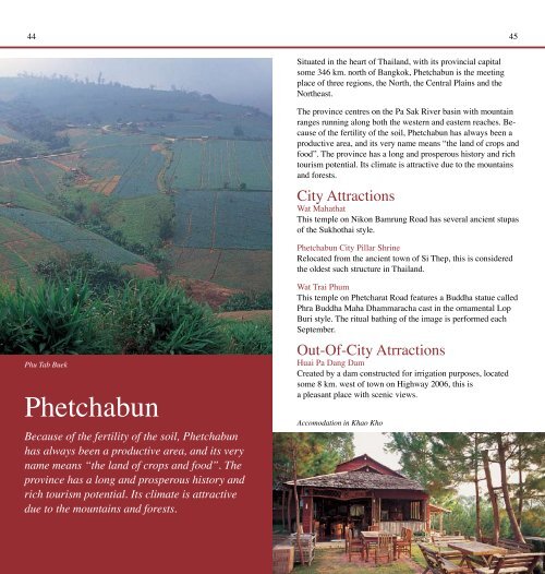
44 45Situated in the heart <strong>of</strong> <strong>Thailand</strong>, with its provincial capitalsome 346 km. north <strong>of</strong> Bangkok, Phetchabun is the meetingplace <strong>of</strong> three regions, the North, the Central Plains and theNortheast.The province centres on the Pa Sak River basin with mountainranges running along both the western and eastern reaches. Because<strong>of</strong> the fertility <strong>of</strong> the soil, Phetchabun has always been aproductive area, and its very name means “the land <strong>of</strong> crops andfood”. The province has a long and prosperous history and richtourism potential. Its climate is attractive due to the mountainsand forests.City AttractionsWat MahathatThis temple on Nikon Bamrung Road has several ancient stupas<strong>of</strong> the <strong>Sukhothai</strong> style.Phetchabun City Pillar ShrineRelocated from the ancient town <strong>of</strong> Si Thep, this is consideredthe oldest such structure in <strong>Thailand</strong>.Phu Tab BuekPhetchabunBecause <strong>of</strong> the fertility <strong>of</strong> the soil, Phetchabunhas always been a productive area, and its veryname means “the land <strong>of</strong> crops and food”. Theprovince has a long and prosperous history andrich tourism potential. Its climate is attractivedue to the mountains and forests.Wat Trai PhumThis temple on Phetcharat Road features a Buddha statue calledPhra Buddha Maha Dhammaracha cast in the ornamental LopBuri style. The ritual bathing <strong>of</strong> the image is performed eachSeptember.Out-Of-City AtrractionsHuai Pa Dang DamCreated by a dam constructed for irrigation purposes, locatedsome 8 km. west <strong>of</strong> town on Highway 2006, this isa pleasant place with scenic views.Accomodation in Khao Kho
46 47Tat Mok National ParkThis forest park has a huge waterfall fed by streams flowingdown mountain crevices, creating twelve beautiful tiers. Toreach the park, drive east for some 15 km. to Ban ChaliangLap, then take a right turn onto Highway 2275, then a left fork,continuing for 20 km.Si Thep Historical ParkSome 130 km. south <strong>of</strong> Phetchabun on Highway 21, and another9 km. after a left turn, lie the ruins <strong>of</strong> Si Thep. An ancient townwhere many structures still remain indicative <strong>of</strong> its past prosperityduring the 11 th -18 th Buddhist Centuries, Si Thep was thecentre <strong>of</strong> contact between the Dvaravati Kingdom in the CentralPlains and the Khmer Kingdom in the Northeast. There arewidespread remains <strong>of</strong> laterite buildings and <strong>of</strong> several ponds.Artefacts found here include elaborate lintels, Sema stones(used to mark out the limits <strong>of</strong> Buddhist temples) and jewellery.Khao KhoBare 1,000 m. high mountains to the northwest <strong>of</strong> town, KhaoKho was a base from which communist insurgents conductedtheir struggle from 1968 to1982. It is accessible via two routes:<strong>of</strong>f Highway 12 (Phitsanulok-Lom Sak) at Ban Camp Son,and <strong>of</strong>f Highway 21 at Ban Na Ngua, about 13 km. north <strong>of</strong>town. Both routes wind through steep terrain. Interesting placesinclude various viewing points, remains <strong>of</strong> guerrilla bases, a warmemorial, an arms museum, a stupa containing a holy relic, theSi Dit Falls and a royal palace.B.N. FarmThis experimental farm grows cold-climate crops, includingvarious flowers which bloom in season and is beautifully scenic.It is situated on the route to Khao Kho 3 km. from Ban CampSon, <strong>of</strong>f Highway 21 to the north <strong>of</strong> town. Fruit-based items areon sale.Phu Hin Rong KlaLocated in the mountains northwest <strong>of</strong> Lom Sak, in the north <strong>of</strong>the province, amidst exotic scenery, this was a communist guerrillabase in the 1970s and 1980s. See the Phitsanulok sectionfor more information.Namtok Man Daeng, Phu Hin Rong KlaNam Nao National ParkIts <strong>of</strong>fice located some 50 km. east <strong>of</strong> Lom Sak along Highway12, this is an immense tract <strong>of</strong> dry evergreen forest. Spread overrolling hills and including pineries and grasslands, it is the habitat<strong>of</strong> many diverse animals, and more than 100 bird species. InDecember and January, the temperature can drop to as low as2 degrees Celsius. Points <strong>of</strong> interest are spread out. Attractionsreached by taking Highway 12 include: Tham Pha Hong withstalactites and stalagmites, located 300 m. north from Km.39;Ban Paek Pinery, reached by a 5 km. walk from Km.49; PhuKhum Khao Pinery, 15 km. from Km.53, covering an area <strong>of</strong>about 10 sq.km. and Heo Sai and Sai Thong Falls, located onthe same trail, reached on foot, 1 km. and 1.5 km. respectively<strong>of</strong>f the main road at Km.67. There are also attractions on Highway2216 (Lom Kao-Huai Sanam Sai) such as Pha Lom-PhaKong which are 5 km. from Km.40 and Tham Yai Nam Naonear Km.60.FestivalsSweet Tamarind DayJanuary-FebruarySweet tamarind is strongly associated with Phetchabun andSweet Tamarind Day celebrates the harvest <strong>of</strong> this fruit. Duringthe festival, farmers bring their sweet tamarinds to sell atreasonable prices at Phetchabun’s provincial athletic field where