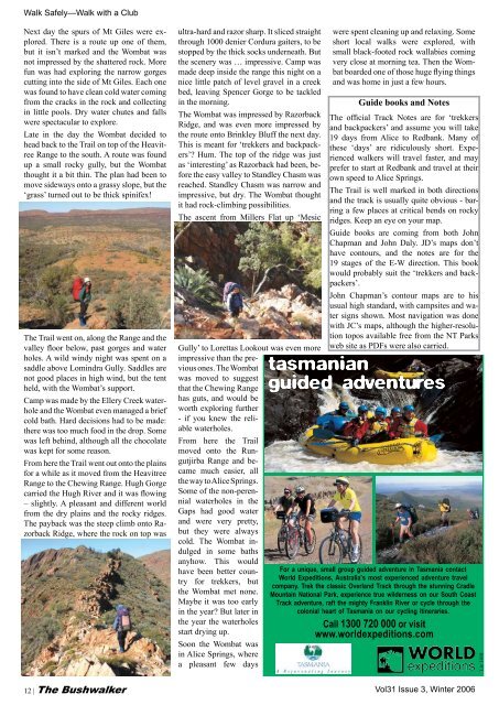
Walk Safely—Walk with a ClubNext day the spurs <strong>of</strong> Mt Giles were explored.There is a route up one <strong>of</strong> them,but it isn’t marked and the Wombat wasnot impressed by the shattered rock. Morefun was had exploring the narrow gorgescutting into the side <strong>of</strong> Mt Giles. Each onewas found to have clean cold water comingfrom the cracks in the rock and collectingin little pools. Dry water chutes and fallswere spectacular to explore.Late in the day the Wombat decided tohead back to the Trail on top <strong>of</strong> the HeavitreeRange to the south. A route was foundup a small rocky gully, but the Wombatthought it a bit thin. The plan had been tomove sideways onto a grassy slope, but the‘grass’ turned out to be thick spinifex!The Trail went on, along the Range and thevalley floor below, past gorges and waterholes. A wild windy night was spent on asaddle above Lomindra Gully. Saddles arenot good places in high wind, but the tentheld, with the Wombat’s support.Camp was made by the Ellery Creek waterholeand the Wombat even managed a briefcold bath. Hard decisions had to be made:there was too much food in the drop. Somewas left behind, although all the chocolatewas kept for some reason.From here the Trail went out onto the plainsfor a while as it moved from the HeavitreeRange to the Chewing Range. Hugh Gorgecarried the Hugh River and it was flowing– slightly. A pleasant and different worldfrom the dry plains and the rocky ridges.The payback was the steep climb onto RazorbackRidge, where the rock on top wasultra-hard and razor sharp. It sliced straightthrough 1000 denier Cordura gaiters, to bestopped by the thick socks underneath. Butthe scenery was … impressive. Camp wasmade deep inside the range this night on anice little patch <strong>of</strong> level gravel in a creekbed, leaving Spencer Gorge to be tackledin the morning.The Wombat was impressed by RazorbackRidge, and was even more impressed bythe route onto Brinkley Bluff the next day.This is meant for ‘trekkers and backpackers’?Hum. The top <strong>of</strong> the ridge was justas ‘interesting’ as Razorback had been, beforethe easy valley to Standley Chasm wasreached. Standley Chasm was narrow andimpressive, but dry. The Wombat thoughtit had rock-climbing possibilities.The ascent from Millers Flat up ‘MesicGully’ to Lorettas Lookout was even moreimpressive than the previousones. The Wombatwas moved to suggestthat the Chewing Rangehas guts, and would beworth exploring further- if you knew the reliablewaterholes.From here the Trailmoved onto the RungutjirbaRange and becamemuch easier, allthe way to Alice Springs.Some <strong>of</strong> the non-perennialwaterholes in theGaps had good waterand were very pretty,but they were alwayscold. The Wombat indulgedin some bathsanyhow. This wouldhave been better countryfor trekkers, butthe Wombat met none.Maybe it was too earlyin the year? But later inthe year the waterholesstart drying up.Soon the Wombat wasin Alice Springs, wherea pleasant few dayswere spent cleaning up and relaxing. Someshort local walks were explored, withsmall black-footed rock wallabies comingvery close at morning tea. Then the Wombatboarded one <strong>of</strong> those huge flying thingsand was home in just a few hours.Guide books and <strong>No</strong>tesThe <strong>of</strong>ficial Track <strong>No</strong>tes are for ‘trekkersand backpackers’ and assume you will take19 days from Alice to Redbank. Many <strong>of</strong>these ‘days’ are ridiculously short. Experiencedwalkers will travel faster, and mayprefer to start at Redbank and travel at theirown speed to Alice Springs.The Trail is well marked in both directionsand the track is usually quite obvious - barringa few places at critical bends on rockyridges. Keep an eye on your map.Guide books are coming from both JohnChapman and John Daly. JD’s maps don’thave contours, and the notes are for the19 stages <strong>of</strong> the E-W direction. This bookwould probably suit the ‘trekkers and backpackers’.John Chapman’s contour maps are to hisusual high standard, with campsites and watersigns shown. Most navigation was donewith JC’s maps, although the higher-resolutiontopos available free from the NT Parksweb site as PDFs were also carried.tasmanianguided adventuresFor a unique, small group guided adventure in Tasmania contactWorld Expeditions, Australia’s most experienced adventure travelcompany. Trek the classic Overland Track through the stunning CradleMountain National Park, experience true wilderness on our South CoastTrack adventure, raft the mighty Franklin River or cycle through thecolonial heart <strong>of</strong> Tasmania on our cycling itineraries.Call 1300 720 000 or visitwww.worldexpeditions.comLic 141812 | The Bushwalker<strong>Vol</strong><strong>31</strong> Issue 3, Winter 2006
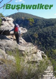
Walk Safely—Walk with a ClubOn the weekend <strong>of</strong> 11-March-06 I travelleddown the south coast <strong>of</strong> NSW to MysteryBay, south <strong>of</strong> Narooma to join the ShoalhavenBushwalkers for a weekend <strong>of</strong> carcamping, kayaking and bushwalking. Onewalk on the agenda was the steep trek upthe slopes <strong>of</strong> nearby Mount Dromedary, awalk I had wanted to do for many years.On Sunday 12th March five members <strong>of</strong>our large party decided today was the day.A clear sky, the sun beating down and thetemperature rising into the early 30s. Weneeded our heads read to be climbing the730 m to the summit <strong>of</strong> Mt Dromedary. Itwas 9.15 am when we jumped into Jan’scar for the 15 minute drive to the smallvillage <strong>of</strong> Tilba Tilba. We parked the caron a vacant patch next to Pam’s GeneralStore, put on our packs and set <strong>of</strong>f on thetrail which commences next to the store. Asmall breeze had started which did help tocool us but it was still quite hot.At first the Tilba Tilba track is quite wideand level and passes between dairy farms,but it soon ascends to a locked gate. Fromhere we had good views <strong>of</strong> the rocky westernflank <strong>of</strong> Little Dromedary to the east.By now the temperature had risen considerablyand already my shirt was soaked insweat - and we had hardly begun the walk.We continued on, the vegetation either side<strong>of</strong> the track quite thick and providing ampleshade. The track ascends continually, butthankfully the ascent isn’t overly steep andwe set an easy pace. We were starting togain some height and got occasional viewsthrough the trees <strong>of</strong> the coast below us, butI made an effort not to look at the summitabove as the distance to the top may justdampen my enthusiasm in this heat. I continuallysipped water from my hydrationbag, hoping the 3 litres would last the expected5 hour journey.<strong>Vol</strong><strong>31</strong> Issue 3 Winter 2006MOUNT DROMEDARYPaul Ellis (Shoalhaven Bushwalkers)Two party members at one <strong>of</strong> the TorsBefore long we passed a cairn on the right<strong>of</strong> the track, about 2 km from the start. Thismarks the grave in the nearby bush nearby<strong>of</strong> an unknown Chinaman, a miner from the1800s who died here after gold was discoveredon the mountain. The track itself wascreated by the miners during the gold rush.We climbed on, setting a steady pace butstopping for regular breathers. I was quitesurprised when we passed ‘Halfway Rock’a large granite boulder set at the left side <strong>of</strong>the track. Just a few metres past this rock isa well defined Battery Track leading <strong>of</strong>f tothe left for about 800 metres to where theold miners once had a steam powered rockcrusher. Some items <strong>of</strong> old equipment maystill be found in the area.We stopped for morning tea on some smallrocks in the track about 100 metres furtherup. The rest break was welcome after theclimb so far. We continued on, the tracksteeply climbing to the saddle. I concentratedon keeping a steady pace without tryingto push myself too hard. I felt the otherswere doing the same, no one was fallingbehind or pushing ahead too far. Eventuallywe passed a pit toilet to the left and just beyondwas a shelter and a large log table. Wehad arrived at Dromedary Saddle.It was here we were told that we could finda small footpad into the forest that wouldtake us to some impressive rock formations.We found the track behind the pittoilet and followed it for a short distancethrough the forest before we reached anamazing scene. Rock Tors and monolithsrose from the forest floor and dominated theforest. We were informed this was a sacredA spectacular balancing rockaboriginal area, for most <strong>of</strong> the formationshad a rather phallic resemblance. We spentthe next 30 minutes exploring. The shapesand colours were magnificent and I ran mydigital camera batteries low by continuallytaking photograph after photograph.The formations continued on and on, occasionallygiving us excellent views <strong>of</strong> thecoastline below, some framed with treeferns and other rainforest plant species.However, our main aim was to reach thesummit <strong>of</strong> Dromedary Mountain, so weheaded back to the saddle and followed thesignposted track through thick rainforest asit again started to ascend steeply.After a short distance we passed a signpostthat signalled a short cut track whichascended very steeply to the summit. Wedecided we would return via this track andinstead, follow the rainforest circuit to thesummit. The rainforest track was magnificent.Many species <strong>of</strong> plant and tree, manyYet another phallic Torsignposted along the trail such as the giantPinkwood and Sassafras and the floor <strong>of</strong>the rainforest adorned by ferns, lichens andmosses. The walk was so interesting thatwe were almost able to ignore the steepness<strong>of</strong> the track to the top and eventually wecame out onto the summit at exactly 1.05pm and sat down at the trig to enjoy lunch.The summit was well overgrown, but stillprovided views <strong>of</strong> the coast, but the bestpart was the cool breeze that helped driveaway the heat we had built up during theascent. With lunch finished we shoulderedour packs for the descent back to the car atTilba Tilba.As we reached the end <strong>of</strong> the forested areajust above the farmland we were treated to awonderfully strong cool breeze that almostknocked us <strong>of</strong>f our feet. We had just onekilometre to walk to Pam’s General Storeand a refreshing ice cold drink, my hydrationbag had only just lasted the day’s walk.We arrived back at 3.00 pm and were backat Mystery Bay Camping Area 15 minuteslater.The Bushwalker | 13