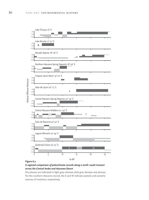
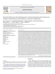
latorre et al. 85metres) at Quebrada Chaco and in <strong>the</strong> central <strong>Atacama</strong>. Aggradation beginningat approximately 20,800 cal. BP, however, agrees with low elevation middenevidence that <strong>the</strong>re was an earlier pluvial period between 23,800 and 18,100years ago. One source for this earlier pluvial could be <strong>the</strong> enhancement ornorthward migration <strong>of</strong> westerly storm tracks during <strong>the</strong> last glacial maximum(LGM). In <strong>the</strong> Holocene, absence <strong>of</strong> wetland deposits along with impoverishedmidden floras implies widespread aridity, with a slight increase in moistureover <strong>the</strong> last 1500 years. This pattern is clearly different from that foundfur<strong>the</strong>r north, and implies that increases in summer precipitation during<strong>the</strong> mid-Holocene were <strong>of</strong> insufficient magnitude to have reached QuebradaChaco. Ongoing work in <strong>the</strong> sou<strong>the</strong>rn <strong>Atacama</strong>, at localities directly north andsouth <strong>of</strong> Quebrada Chaco, will enable us to place both a maximum northwardlimit to <strong>the</strong> westerly excursion during <strong>the</strong> LGM as well as establishing <strong>the</strong>sou<strong>the</strong>rn limit <strong>of</strong> increased summer moisture during <strong>the</strong> late Glacial andmid-Holocene.Towards a regional syn<strong>the</strong>sisFigure 6.2 compares effective moisture interpretations from <strong>the</strong> diverse array<strong>of</strong> records <strong>of</strong> continental climate change now available. Large discrepancies inpalaeoclimate interpretation are readily apparent.Ω Lake cores from <strong>the</strong> Altiplano, including Lake Titicaca (Baker et al.2001b) and Salar de Uyuni (Baker et al. 2001a), seem to indicate a wetLGM (over 20,000 years ago) — a pattern not seen along <strong>the</strong> Pacificslope <strong>of</strong> <strong>the</strong> Andes except in <strong>the</strong> Salar de <strong>Atacama</strong> salt core (Bobstet al. 2001) and in <strong>the</strong> sou<strong>the</strong>rn <strong>Atacama</strong>. There are disagreementsbetween core and shoreline evidence for palaeolakes on <strong>the</strong> BolivianAltiplano. Twice in <strong>the</strong> last 110,000 years, overflow from Lake Titicacainundated and, when lake levels rose above 3700 metres, integrateddrier basins to <strong>the</strong> south (Poopó, Coipasa and Uyuni). The radiocarbonchronology for <strong>the</strong> oldest shoreline (Palaeolake Minchin) above 3700metres is questionable, and in <strong>the</strong> process <strong>of</strong> being resolved throughU-series dating. The younger and higher shoreline above 3700 metres(Palaeolake Tauca) is also being redated, but previous dates range
86 part one environmental historyFigure 6.2A regional comparison <strong>of</strong> paleoclimate records along a north–south transectacross <strong>the</strong> Central Andes and <strong>Atacama</strong> <strong>Desert</strong>Dry phases are indicated in light grey whereas dark grey denotes wet phases.For <strong>the</strong> sou<strong>the</strong>rn <strong>Atacama</strong> record, <strong>the</strong> E and W indicate easterly and westerlysources <strong>of</strong> moisture, respectively.