

Port Hedland maps 1-7 - Planning WA
Port Hedland maps 1-7 - Planning WA
Port Hedland maps 1-7 - Planning WA
- No tags were found...

Create successful ePaper yourself
Turn your PDF publications into a flip-book with our unique Google optimized e-Paper software.
WEDGEFIELDPORT HEDLANDBOODARIE<strong>WA</strong>LNUT GROVELAWSONSHELLBOROUGHPIPPINGARRATOWN CENTRECASSIASOUTH HEDLANDKOOMBANABOODARIE°0 5001000metresLegendLot status (as at July 2009)fully developedfully developed -non residentialpartially developedpartially developed -residential (& othermixed uses)cadastresuburb boundaryprecinct boundaryTown of<strong>Port</strong> <strong>Hedland</strong>Shire ofEast PilbaraMAP 6:Integrated LandInformation Database (ILID)outputs - South <strong>Hedland</strong>Produced by Infrastructure <strong>Planning</strong> Branch,Department of <strong>Planning</strong>.Base information supplied byWestern Australian Land Information Authority,LI 430-2009-2.Date 7/1/2011partially developed -non residentialundeveloped - vacantundeveloped - no data128 Western Australian <strong>Planning</strong> Commission
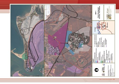
See A3 <strong>Port</strong> <strong>Hedland</strong> mapFINUCANE<strong>Port</strong> <strong>Hedland</strong> <strong>Port</strong> Authority* indicative expansion areas* includes Lumsden Hub (logisticshub to support resource andinfrastructure projects in theregion), BHP Billiton and multiuserstockyards* planning under way to develop11 additional berths in the innerharbour over the next 5 years* work also progressing ondevelopment of multi-user outerharbour facility, providing anadditional capacity of 400 Mt/aPORT HEDLANDBHP lease areaREDBANK■Dampier Saltevaporation pondsRedbank* area zoned rural residential and mixedbusiness* future land use options currently underinvestigation* potential tourism uses (as identified in<strong>Port</strong> <strong>Hedland</strong> Land Use Master Plan)* fragmented land ownership* unallocated Crown land to south* recent proposal to initiate amendmentto rezone to tourism not supported bycouncilSee A3 South <strong>Hedland</strong> mapWEDGEFIELDBOODARIEBoodarieIndustrialEstateSee A4 town centre mapSH134■SOUTH HEDLANDSH111PIPPINGARRATwelve Mile* capacity for additional rural residentiallots in this area* recent proposal to rezone lot 26 to ruralresidential refused by council* funding sought through North WestDevelopment Fund to prepare a structureplan guiding land use and developmentover this area* significant portion of area is Crown landwhich has private lease arrangementsin placeSH109SH110Boodarie (general & noxious industry)* area identified for future general &noxious uses (approx. 200 ha required)* area zoned strategic industry* subject to further investigation –drainage patterns, flooding, soil conditions,air quality impacts, heritage etc (studiesunder way)* draft structure plan to be prepared(anticipated early 2011)Produced by Infrastructure <strong>Planning</strong> Branch,Department of <strong>Planning</strong>.Base information supplied by:Western Australian Land Information Authority,LI 430-2009-2.Date: 10/1/2011°0 12502500metresLegendIntended land usecommercial (retail/office)potential mixed businessindustrialpotential industrialmixed useresidentialpotential residentialresidential - key worker housingpotential key worker housingtransient workforceaccommodationpotential transient workforceaccommodationrural residentialtourismBoodarie (strategic industry)* zoned for strategic industrial uses,suitable for downstream processingand support industries* structure planning commencedfor remainder of estate* requires further planning andinvestigative studiescadastresuburb boundaryrail networkcommercial, mixed business,town centre zonesindustry, strategic industryzoneswastewater treatment plantbuffer■ wastewater treatment plantSouth <strong>Hedland</strong> Rural Estate* conditional approvals in placeto develop an additional 79 lotsTown of<strong>Port</strong><strong>Hedland</strong>Shire ofEastPilbaraNote:The extent and timing of projectareas are indicative only. No onusis placed on the landowner orrelevant agency to comply withthese representations. Proposals fordevelopment on each site must stillfollow relevant planning procedures.MAP 7:Future Development -<strong>Port</strong> <strong>Hedland</strong> OverviewWestern Australian <strong>Planning</strong> Commission 129


