Critical Areas Ordinance Best Available Science ... - City of Bremerton
Critical Areas Ordinance Best Available Science ... - City of Bremerton
Critical Areas Ordinance Best Available Science ... - City of Bremerton

You also want an ePaper? Increase the reach of your titles
YUMPU automatically turns print PDFs into web optimized ePapers that Google loves.
CAO ORDINANCE EXHIBIT A – ATTACHMENT I<br />
<strong>City</strong> <strong>of</strong> <strong>Bremerton</strong>’s<br />
<strong>Critical</strong> Area <strong>Ordinance</strong><br />
<strong>Best</strong> <strong>Available</strong> <strong>Science</strong> References<br />
Growth Management Act Requirements<br />
In 1995 the Washington State Growth Management Act was amended to require the<br />
use <strong>of</strong> “<strong>Best</strong> <strong>Available</strong> <strong>Science</strong>” (BAS) when designating and protecting <strong>Critical</strong> <strong>Areas</strong>.<br />
The Act requires that cities and counties include best available science in developing<br />
policies and development regulations to protect the functions and values <strong>of</strong> critical<br />
areas. Five critical areas are identified by the GMA<br />
(RCW 36.70A.030 [5]):<br />
• Wetlands;<br />
• <strong>Critical</strong> Aquifer Recharge <strong>Areas</strong>;<br />
• Frequently flooded areas;<br />
• Geologically hazardous areas and;<br />
• Fish and wildlife habitat conservation areas.<br />
In addition, RCW 36.70A.172(1) states that special consideration must be given to<br />
“measures necessary to preserve or enhance anadromous fisheries,” which refers to<br />
those species that reproduce in fresh water and migrate to salt water for some portion <strong>of</strong><br />
their life, returning to fresh water. The term “fisheries” commonly refers to stocks <strong>of</strong> fish<br />
that are managed for commercial, recreational, cultural, or ceremonial uses (WDFW,<br />
1997).<br />
In response to this legislation, the State Office <strong>of</strong> Community, Trade, and Economic<br />
Development (CTED) promulgated rules to guide cities and counties in identifying and<br />
including the best available science in their critical area policies and regulations. These<br />
rules are found under WAC 365-195-900-925.<br />
BAS Process<br />
The <strong>City</strong> <strong>of</strong> <strong>Bremerton</strong> heavily relied upon the existing BAS literature determined by<br />
other local, state and federal natural resource agencies to meet the BAS Criteria (WAC<br />
365-195-905(2)). Review <strong>of</strong> BAS for local applicability to the <strong>City</strong> <strong>of</strong> <strong>Bremerton</strong> was<br />
assisted by a Technical Review Committee, convened by the <strong>City</strong> and composed <strong>of</strong><br />
representatives from local, state and natural resource agencies, and various community<br />
stakeholder groups. Committee members were guided by a duty and purpose <strong>of</strong><br />
assisting the city in determining what BAS is appropriate to consider” in updating the<br />
CAO.<br />
References<br />
When applicable the references will be separated by the critical area section however<br />
many references were used in several sections and are therefore listed as general<br />
references. While this represents an extensive list <strong>of</strong> CAO citations, it may not be all<br />
the best available science currently published on the subject.<br />
1 <strong>of</strong> 7
CAO ORDINANCE EXHIBIT A – ATTACHMENT I<br />
General References<br />
King County. 2003 BAS Review<br />
Kitsap County, Department <strong>of</strong> Community Development. 2004. Kitsap County’s Draft<br />
<strong>Critical</strong> <strong>Areas</strong> <strong>Ordinance</strong>: Review <strong>of</strong> <strong>Best</strong> <strong>Available</strong> <strong>Science</strong>.<br />
Municipal Research and Services Center <strong>of</strong> Washington. 2004. Website. <strong>City</strong> and<br />
county codes for Washington State jurisdictions available at URL =<br />
http://www.mrsc.org/codes.aspx<br />
RCW 36.70A.172 <strong>Critical</strong> <strong>Areas</strong> – Designation and Protection – <strong>Best</strong> <strong>Available</strong><br />
<strong>Science</strong>.<br />
WAC 365-190-080 <strong>Critical</strong> <strong>Areas</strong>.<br />
WAC 365-195-900 <strong>Best</strong> <strong>Available</strong> <strong>Science</strong>.<br />
Washington State Department <strong>of</strong> Community, Trade, and Economic Development.<br />
2003. <strong>Critical</strong> <strong>Areas</strong> Handbook: Protecting <strong>Critical</strong> <strong>Areas</strong> within the Framework <strong>of</strong> the<br />
Washington Growth Management Act.<br />
Washington State Department <strong>of</strong> Community Trade, and Economic Development. 2002.<br />
Model Code Recommendations for Designating and Protecting <strong>Critical</strong> <strong>Areas</strong>, First<br />
Edition, 2nd Draft. Prepared by Berryman & Henigar Inc., Adolfson Associates Inc., and<br />
GeoEngineers, Inc. OCD, Olympia, WA.<br />
Washington State Department <strong>of</strong> Ecology. 2001. Focus: Riparian <strong>Areas</strong>. Washington<br />
Department <strong>of</strong> Ecology. <strong>Available</strong> online at:<br />
http://www.ecy.wa.gov/pubs/0010023.pdf<br />
Washington State Department <strong>of</strong> Ecology. Digital Coastal Zone Atlas.<br />
<strong>Available</strong> online at: http://www.ecy.wa.gov/programs/sea/SMA/atlas_home.html<br />
Other Jurisdictions <strong>Critical</strong> Area <strong>Ordinance</strong>s and <strong>Best</strong><br />
<strong>Available</strong> <strong>Science</strong> Reviewed<br />
<strong>City</strong> <strong>of</strong> Auburn, Bainbridge Island, <strong>City</strong> <strong>of</strong> Bellevue, <strong>City</strong> <strong>of</strong> Edmonds, <strong>City</strong> <strong>of</strong> Everett,<br />
<strong>City</strong> <strong>of</strong> Issaquah, <strong>City</strong> <strong>of</strong> Kent, <strong>City</strong> <strong>of</strong> Mukilteo, <strong>City</strong> <strong>of</strong> Port Townsend<br />
<strong>City</strong> <strong>of</strong> Tacoma, <strong>City</strong> <strong>of</strong> Shoreline, <strong>City</strong> <strong>of</strong> Redmond, <strong>City</strong> <strong>of</strong> Renton, Kitsap County,<br />
Pierce County<br />
2 <strong>of</strong> 7
CAO ORDINANCE EXHIBIT A – ATTACHMENT I<br />
Section 20.14.300 – Wetlands<br />
Kitsap County Surface Water Resources Map. (includes all streams, wetlands, lakes<br />
and marine waters <strong>of</strong> the Puget Sound) URL:<br />
http://www.kitsapgov.com/dcd/gis/maps/Environmental/Streams_and_Surface_WaterD<br />
EC2005.pdf<br />
Kitsap County Wetland and Hydric Soils Map:<br />
http://www.kitsapgov.com/dcd/gis/maps/Environmental/WETLANDS_HYDRIC.pdf<br />
Washington State Department <strong>of</strong> Ecology. 2004. Guidance on Wetland Mitigation in<br />
Washington State Part 1: Laws, Rules, Policies, and Guidance Related to Wetland &<br />
Mitigation & Part 2: Guidelines for Developing Wetland Mitigation Plans and Proposals<br />
(Ecology Publications # 04-06-013a & # 04-06-013b)<br />
Washington State Department <strong>of</strong> Ecology. 1997. Washington State Wetlands<br />
Identification and Delineation Manual (Ecology Publication # 96-94).<br />
Washington State Department <strong>of</strong> Ecology. 2004. Washington State Wetlands Rating<br />
System – Western Washington (Ecology Publication # 04-06-025)<br />
Washington State Department <strong>of</strong> Ecology. 1992. Wetland Buffers: Use and<br />
Effectiveness, and Appendices (Ecology Publications # 92-10 & 92-10a)<br />
Washington State Department <strong>of</strong> Ecology & Washington State Department <strong>of</strong> Fish and<br />
Wildlife. 2005. Wetlands in Washington State – Volume 1: A Synthesis <strong>of</strong> the <strong>Science</strong><br />
& Volume 2: Guidance for Protecting and Managing Wetlands (Ecology Publications<br />
#05-06-006 & #05-06-008)<br />
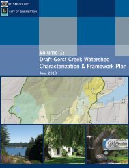
Section 20.14.400 – <strong>Critical</strong> Aquifer Recharge <strong>Areas</strong><br />
AGI Technologies Water Resource Group. 1996. Technical Memorandum #3<br />
Conceptual Hydrogeological Model Gorst Creek Basin. Publication reference number<br />
15842.001<br />
<strong>Bremerton</strong>-Kitsap County Board <strong>of</strong> Health <strong>Ordinance</strong> 2-1991, Rules and Regulations for<br />
Public and Private Water Supplies.<br />
Kitsap County <strong>Critical</strong> Aquifer Recharge Area Map. URL:<br />
http://www.kitsapgov.com/dcd/gis/maps/environmental/Aquifier_Rechage_<strong>Areas</strong>.pdf<br />
(Accessed 11/24/05)<br />
Kitsap Public Utilities District. Issue Paper: Well Construction and Decommissioning.<br />
Volume 4 Appendix 2. May 20, 1997.<br />
URL:http://www.kpud.org/reference/docs/kc_groundwater/wellcons.pdf<br />
3 <strong>of</strong> 7
CAO ORDINANCE EXHIBIT A – ATTACHMENT I<br />
Kitsap Public Utilities District. Issue Paper: Aquifer Water Balance (WB), Volume 4<br />
Appendix 2. May 20, 1997. URL:<br />
http://www.kpud.org/reference/docs/kc_groundwater/waterbal.pdf<br />
Puget Sound Action Team. 2005 “Low Impact Development Technical Guidance<br />
Document for Puget Sound” URL:<br />
http://www.psat.wa.gov/Publications/LID_tech_manual05/LID_manual2005.pdf<br />
RCW 18.104 - Water Well Construction Act (1971)<br />
RCW 43.20. Public Water Systems – Penalties and Compliance.<br />
RCW 70.119A. State Board <strong>of</strong> Health.<br />
U.S. Environmental Protection Agency. 2003. “Potential sources <strong>of</strong> drinking water<br />
contamination index. URL: http://www.epa.gov/safewater/swp/sources1.html (Accessed<br />
Nov. 2005)<br />
U.S. Environmental Protection Agency; Office <strong>of</strong> Ground-Water Protection; Office <strong>of</strong><br />
Water. 1990. “Citizen’s Guide to Ground-Water Protection”<br />
WAC 173-160 - Minimum Standards for Construction and Maintenance <strong>of</strong> Wells.<br />
WAC 246-290 - Drinking Water Regulations - State Board <strong>of</strong> Health<br />
Washington State Department <strong>of</strong> Ecology. 2000. Guidance document for the<br />
establishment <strong>of</strong> critical aquifer recharge area ordinances. (Ecology Publication # 05-<br />
10-028)<br />
Washington State Department <strong>of</strong> Health. 2005. Washington’s Source Water<br />
Assessment Program. DOH publication # 331-148<br />
Section 20.14.500 – Frequently Flooded <strong>Areas</strong><br />
US Department <strong>of</strong> Housing and Urban Development. 1979. Flood Boundary and<br />
Floodway Map, panel 15.<br />
Section 20.14.600 – Geologically Hazardous <strong>Areas</strong><br />
Kitsap County, Department <strong>of</strong> Community Development. 2003. Kitsap County’s Draft<br />
<strong>Critical</strong> <strong>Areas</strong> <strong>Ordinance</strong>: Review <strong>of</strong> <strong>Best</strong> <strong>Available</strong> <strong>Science</strong> – Geologically Hazardous<br />
<strong>Areas</strong>. Port Orchard, WA.<br />
Kitsap County Geologically Hazardous <strong>Areas</strong> Map. URL:<br />
http://www.kitsapgov.com/dcd/gis/maps/Environmental/Geohazards_DEC2005.pdf<br />
4 <strong>of</strong> 7
CAO ORDINANCE EXHIBIT A – ATTACHMENT I<br />
Soil Survey <strong>of</strong> Kitsap County Area, Washington. United State Department <strong>of</strong> Agriculture,<br />
Soil Conservation Service in cooperation with Washington State Department <strong>of</strong> Natural<br />
Resources and Washington State University, Agricultural Research Center.<br />
GIS Data Layer, Quaternary Geology and Stratigraphy <strong>of</strong> Kitsap County. Based on<br />
Jerald Deeter 1979 thesis (WWU).<br />
http://www.kitsapgov.com/gis/metadata/enviro/stability.htm<br />
<strong>City</strong> <strong>of</strong> Edmonds <strong>Best</strong> <strong>Available</strong> <strong>Science</strong> Report. 2004. Prepared by EDAW Inc.,<br />
Seattle, WA.<br />
<strong>City</strong> <strong>of</strong> Issaquah <strong>Best</strong> <strong>Available</strong> <strong>Science</strong> Report. 2004. Prepared by Issaquah Planning<br />
Department, Issaquah, WA.<br />
International Society <strong>of</strong> Arbiculture (ISA) Trees Are Good. Pruning Techniques.<br />
www.treesaregood.com/treecare/pruning_mature.aspx<br />
United States Department <strong>of</strong> Agriculture (USDA) How to Prune Trees.<br />
www.na.fs.fed.us/spfo/pubs/howtos/ht_prune/prun001.htm<br />
Dr. Ed Gilman, University <strong>of</strong> Florida. Pruning Shade Trees In The Landscape.<br />
<strong>Best</strong> <strong>Available</strong> <strong>Science</strong> Issue Paper: Snoqualmie Watershed Near Term Action Agenda<br />
Implementation Project. March 2004.<br />
Jefferson County Review <strong>of</strong> <strong>Best</strong> <strong>Available</strong> <strong>Science</strong> for 2004 Comprehensive Plan<br />
and Development Regulations Update.<br />
King County <strong>Best</strong> <strong>Available</strong> <strong>Science</strong>: Volume I Review <strong>of</strong> <strong>Science</strong> Literature. Chapter 5<br />
Geologic Hazard <strong>Areas</strong>.<br />
Thurston County <strong>Best</strong> <strong>Available</strong> <strong>Science</strong> / Guidance Geologic Hazard <strong>Areas</strong>. July 2005.<br />
Shipman, Hugh. 2001. Coastal landsliding on Puget Sound: A review <strong>of</strong><br />
landslides occurring between 1996 and 1999. Washington Department <strong>of</strong><br />
Ecology. Report #01-06-019.<br />
Washington Department <strong>of</strong> Ecology. Controlling Erosion Using Vegetation.<br />
http://www.ecy.wa.gov/programs/sea/pubs/93-30/index.html<br />
Washington Department <strong>of</strong> Ecology. Managing Vegetation on Coastal Slopes.<br />
http://www.ecy.wa.gov/programs/sea/pubs/93-31/intro.html<br />
USGS Seismic Hazards Investigation in Puget Sound (SHIPS). A U.S. / Canadian<br />
5 <strong>of</strong> 7
CAO ORDINANCE EXHIBIT A – ATTACHMENT I<br />
Consortium to provide public information for mitigating a potential earthquake disaster in<br />
the Pacific Northwest. http://walrus.wr.usgs.gov/ships/<br />
The Pacific Northwest Seismograph Network (PNSN). All about earthquakes and<br />
geologic hazards <strong>of</strong> the Pacific Northwest.<br />
http://www.pnsn.org/INFO_GENERAL/faq.html.<br />
International Building Code 2003. International Code Council, Inc. ISBN #1-892395-<br />
56-8.<br />
USGS Quaternary Fault and Fold Database for the United States.<br />
http://earthquake.usgs.gov/regional/qfaults/wa/sea.html.<br />
Tsunamis on the Pacific Coast <strong>of</strong> Washington State and Adjacent <strong>Areas</strong> – A Selected,<br />
Annotated Bibliography and Directory. Compiled by Connie J. Manson and Lee<br />
Walkling. Washington State Department <strong>of</strong> Natural Resources. Open File Report 98-4.<br />
April, 1998.<br />
Tsunami Inundation Map <strong>of</strong> the Port Townsend, Washington, Area. Washington State<br />
DNR. August, 2002.<br />
Tsunami Hazard Map <strong>of</strong> the Elliot Bay Area, Seattle, Washington: Modeled Tsunami<br />
Inundation from a Seattle Fault Earthquake. Walsh, Titov, Venturato, M<strong>of</strong>jeld,<br />
Gonzalez. 2003.<br />
Section 20.14.700 – Fish and Wildlife Habitat<br />
Bellevue <strong>Critical</strong> <strong>Areas</strong> Update. Wildlife BAS Paper. March 2003. URL:<br />
http://www.ci.bellevue.wa.us/departments/Development/pdf. (Accessed 12/7/05)<br />
Kitsap County Fish and Wildlife Habitat Map. URL:<br />
http://www.kitsapgov.com/dcd/gis/maps/Environmental/Fish_and_Wildlife_PHS.pdf<br />
(Accessed 12/08/05)<br />
Kitsap County Watershed Resource Management. URL:<br />
http://www.kitsapgov.com/dcd/nr/wrm/ (Accessed 12/7/05)<br />
Kitsap County, 2000. “Kitsap Peninsula salmonid Refugia Study.” Port Orchard, WA<br />
Knutson, K.L., and V. L. Naef. 1997. Management Recommendations for Washington<br />
Priority Habitats and Species: Riparian. Wash. Dept. Fish and Wildlife., Olympia.<br />
181pp. URL: http://www.wdfw.wa.gov/hab/phsrecs.htm. (Accessed 12/7/05)<br />
Ledwith, Tyler. 1996. “The effects <strong>of</strong> Buffer Strip Width on Air Temperature and Relative<br />
Humidity in a Stream Riparian Zone.” URL: watershed.org/news.sum_96/buffer.html<br />
6 <strong>of</strong> 7
CAO ORDINANCE EXHIBIT A – ATTACHMENT I<br />
May, C.W. 2003. Stream-Riparian Ecosystems in the Puget Sound Lowland Eco-<br />
Region: A Review <strong>of</strong> <strong>Best</strong> <strong>Available</strong> <strong>Science</strong>. Watershed Ecology LLC.<br />
Puget Sound Action Team: June 28, 2005. Compiled and edited by Scott Redman,<br />
Doug Myers, and Dan Averill. “Regional Nearshore and Marine Aspects <strong>of</strong> Salmon<br />
Recovery in Puget Sound” URL:<br />
http://www.psat.wa.gov/Programs/salmon_recovery/RegionalNearshore.pdf<br />
Shared Strategy for Puget Sound. Watershed Pr<strong>of</strong>ile<br />
http://www.sharedsalmonstrategy.org/watersheds/watershed-eastkitsap.htm (Accessed<br />
2/9/06)<br />
WAC 232-12-014 Washington State Endangered Species<br />
WAC 232-12-011 Washington State Threatened and Sensitive Species<br />
WAC 222-16-030 Department <strong>of</strong> Natural Resources Water Typing System<br />
Washington Environmental Council. 2004. Habitat Protection Tool Kit: A Guide to<br />
Habitat Conservation Planning Under Washington’s Growth Management and Shoreline<br />
Management Acts. URL: www.wecprotects.org<br />
Washington Department <strong>of</strong> Fish and Wildlife Priority Habitat and Species Map. Volume<br />
IV: Birds. URL http://wdfw.wa.gov/hab/phs/vol4/sage_grouse.pdf<br />
Washington State Department <strong>of</strong> Ecology. 2005. Protecting Aquatic Ecosystems: A<br />
Guide for Puget Sound Planners to Understand Watershed Processes (Publication #<br />
05-06-013)<br />
Washington State Department <strong>of</strong> Ecology. 2001. Focus: Riparian <strong>Areas</strong>. Washington<br />
Department <strong>of</strong> Ecology (Publication # 00-10-023)<br />
Water Resource Management Plan for Water Resource Inventory Area 15 (WRIA 15)<br />
URL: http://www.kitsappeninsulawatershed.org (Accessed 12/9/05)<br />
7 <strong>of</strong> 7