Data on girls’ and women’s education and literacyThe State of Senegal has committed to achieve schooling for all by 2015. In Kedougouregion however, the education system remains characterized by under-schooling,and particularly that of girls. In 2013, the drop-out rate was 8.9% for boys and 11.2%for girls. 4 Thus, the retention of girls at school is a challenge.Table 1Gender parity indexEducation (level)Number of pupilsGirls BoysGirl/boy RatioBasic education 1,218 1,179 1.03Elementary 12,409 13,782 0.90Middle 3,419 5,449 0.62Secondary 444 1,391 0.32Source: Annuaire statistique national – Année scolaire 2012-2013. 5(National Statistical Yearbook - 2012-2013 School Year)According to the Association of Teachers for the Education of Girls (SCOFI), girls’access to and retention in school conflicts with socio-cultural factors such as earlymarriage and pregnancy, responsibility for housework, poverty, incompatibilitybetween the school and agricultural calendars, and also and especially, traditionalgold-mining.BackgroundWhat is more, according to statistics from the Ministry of National Education for2013, more than half of elementary schools had no sanitary facilities. Thus, 52% ofschools had no toilets and 59% had no access to water. In the region as a whole,only 23% of schools had a handwashing facility. The lack of WASH infrastructure inschools is even more marked in middle and secondary education than in elementary. 6The literacy of the population is also a challenge. According to the National Agencyfor Statistics and Demographics (ANSD), the literacy rate in Kedougou is 35%.Thus, 65% of the population is illiterate. UNESCO data indicate that women accountfor 85% of this group. 7 There are few literacy classes in the region outside the townof Kedougou, the region’s capital, which has a small number. 8124 Senegal Education National Statistical Yearbook 2013, Kedougou School Inspectorate.5 Ministry of Education - Directorate of Education Planning and Reform, Office of Educational Statistics:http://www.education.gouv.sn/root-fr/upload_pieces/ANNUAIRE%20STAT%20EDUCATION%202012%202013.pdf6 Annuaire statistique national – Année scolaire 2012-2013 (National Statistical Yearbook - 2012-2013 SchoolYear), Senegal Ministry of National Education - Directorate of Education Planning and Reform, Office ofEducational Statistics: http://www.education.gouv.sn/root-fr/upload_pieces/ANNUAIRE%20STAT%20EDUCATION%202012%202013.pdf7 Women’s and Girls’ Literacy Project (PAJEF), UNESCO - Regional Office for Education in Africa (Dakar)http://www.unesco.org/new/fileadmin/MULTIMEDIA/FIELD/Dakar/pdf/Fiche_PAJEF_visite_DG.pdf8 Information taken from the Kedougou Municipal Investment Plan (2012). However, this document does notprovide precise figures.
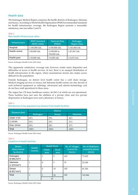
Health dataThe Kedougou Medical Region comprises the health districts of Kedougou, Salemataand Saraya. According to World Health Organization (WHO) recommended standardsfor health infrastructure coverage, the Kedougou Region presents a reasonablysatisfactory rate (see tables 2 and 5).Table 2Main health infrastructure ratiosInfrastructureWHO Standard(WHO 2005)National Data(PNDS)KedougouRegion DataHospital 1:150,000 inh. 1:150,000 inh. 1:141,846 inh.Health centre 1:50,000 inh. 1:100,000 to 1:47,267 inh.150,000 inh.Health post 1:10,000 inh. 1:5,000 inh. 1:5,672 inh.Source: Kedougou Health Centre (2011 data)This apparently satisfactory coverage rate, however, masks many disparities anddifficulties of access to health services. In fact, there is an unequal distribution ofhealth infrastructure in the region, where mountainous terrain also makes accessdifficult for the population.Outside Kedougou, no district level health centre has a cold chain storage.Medical imaging services in Saraya and Salemata health centres are also devoid ofsuch technical equipment as radiology, ultrasound and odonto-stomatology, anddo not have staff specialized in these areas.The region has 176 basic healthcare centres, 46 (26%) of which are not operational.These facilities have just seen the addition of a private clinic and two privatedispensaries in Kedougou town and a pharmacy in Saraya.Table 3Distribution of the population by distance from health facilitiesBackgroundDistance (km)DistrictKedougou Saraya SalemataUnder 5 km 45% 29% 42%5-10 km 25% 33% 31%Over 10 km 30% 38% 27%Total 100% 100% 100%Source: Kedougou Health Centre (2011 data)Table 4Condition of health facilitiesDistrict(Area coveredby district)HealthCentresHealth PostsUrbanareaRuralareaNo. of villagescovered bydistrictKedougou 1 1 9 163 77,652(9 984 km²)Salemata1 0 5 70 23,248(1 970 km²)Saraya1 0 10 102 41,326(6 837 km²)Total 3 1 24 335 141,846Source: Kedougou Health Centre (2011 data)25No. of inhabitantscovered by district(2013)13