Chapter 2: History of petroleum exploration and development - PIRSA
Chapter 2: History of petroleum exploration and development - PIRSA
Chapter 2: History of petroleum exploration and development - PIRSA

Create successful ePaper yourself
Turn your PDF publications into a flip-book with our unique Google optimized e-Paper software.
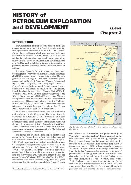
HISTORY <strong>of</strong>PETROLEUM EXPLORATION<strong>and</strong> DEVELOPMENT B.J. O'Neil 1<strong>Chapter</strong> 2INTRODUCTIONThe Cooper Basin has been the focal point for oil <strong>and</strong> gas<strong>exploration</strong> <strong>and</strong> <strong>development</strong> in South Australia since thefirst hydrocarbon discovery there in 1963. The Permo-Carboniferous sediments which comprise the basin wererevealed in Innamincka 1 in 1959. Progress in the region hasresulted in a substantial national <strong>development</strong>, so much sothat by the early 1980s the Moomba facilities were regardedas a Vital National Installation with respect to any actual orpresumed military, terrorist or serious v<strong>and</strong>alism threats oractions.The name ‘Cooper’s Creek Sub-basin’ appears to havebeen adopted in 1962 when the Bureau <strong>of</strong> Mineral Resources(BMR) flew an aeromagnetic survey in the region. Bouguergravity maps resulting in 1965 from helicopter gravitysurveys indicated the basin’s outline (Wongela GeophysicalPty Ltd, 1965; Wopfner, 1965, 1966; Kapel, 1966a, b).Cooper’s Creek Basin attained formal status throughsummaries <strong>of</strong> the extent <strong>of</strong> structural <strong>and</strong> stratigraphicknowledge about the basin (Kapel, 1966a, b; Martin 1967a, b;Wopfner, 1969, 1970). A basin definition referring to the‘Cooper Basin’ was not published (Evans, 1966). Within ashort period <strong>of</strong> time, however, the name was abbreviated forconvenience. This occurred informally at first (Hollingsworth,1989; see, e.g., Condon, 1967) <strong>and</strong> the first publishedreference in a scientific paper highlighting the ‘CooperBasin’ appears to have been that <strong>of</strong> Paten (1969).An outline <strong>of</strong> significant events in <strong>petroleum</strong> <strong>exploration</strong><strong>and</strong> production in the Cooper <strong>and</strong> Eromanga Basins ischronicled in Appendix 1. The account <strong>of</strong> <strong>petroleum</strong><strong>exploration</strong> <strong>and</strong> <strong>development</strong> in the Great Artesian Basin<strong>and</strong> the Eromanga Basin, contained in the second volume <strong>of</strong>the Petroleum geology <strong>of</strong> South Australia series (O’Neil,1996), is extended here to review Cooper Basin <strong>development</strong>s.Also included are notes pertaining to Aboriginal <strong>and</strong>European occupation <strong>of</strong> the region.The names for drillholes, topographic features <strong>and</strong>places in the Cooper Basin reflect both indigenous <strong>and</strong>non-indigenous aspects <strong>of</strong> the area (Wilkinson, 1997; Fig.2.1). Words or phrases from local Aboriginal dialects havebeen adapted <strong>and</strong> adopted in the region (Clel<strong>and</strong> et al., 1925;Johnston <strong>and</strong> Clel<strong>and</strong>, 1943; Johnston, 1943; Wilkinson,1997). For example, Gidgealpa Waterhole apparentlycomes from Kilyalpa, a mythical woman who created thel<strong>and</strong> <strong>and</strong> over whom a grey cloud once appeared while sheprayed for rain (Wilkinson, 1997; see also Manning, 1990);Innamincka from words meaning deep, dark hole, yernaminka (you deep) for the large waterhole in Cooper Creek at1 Consultant Historian, 36 Tallack St, Windsor Gardens SA 5087.135°#S‘Anna Creek’LakeGairdnerNorthern TerritoryOodnadatta%0 100KILOMETRES(South)LakeTorrensª#S#SCooperBirdsvillethis location, or yidriminkani (or yae-ni-mem-gi orYnaminka—you go into the hole); Kopperamanna from thelake which was a meeting place for Aboriginal people nearCooper Creek; P<strong>and</strong>o from the word for lake; the dryclaypans <strong>of</strong> Lake Moonba from moonba (big noise orthunder—Manning, 1990) or from moonda (beyond—Wilkinson, 1997; one version <strong>of</strong> the change <strong>of</strong> the name toMoomba is that American oilmen adapted it for ease <strong>of</strong>pronunciation—Manning, 1990—but another is that it waschanged to match the Melbourne Moomba Festival whichhad been inaugurated in 1955—Wopfner, pers. comm.1998); Boobook from the name for a mopoke bird; Brolgafrom Buralga, a dancer who turned into the bird; Cooba forsome acacia plants <strong>and</strong> Marpoo for the s<strong>and</strong>hill wattle inparticular; <strong>and</strong> Dieri after the lake <strong>and</strong> the main local tribe.#S#SCreekMurray#STrackRiverLakeFromeBetoota 1%SIMPSON DESERT‘CordilloDowns’Patchawarra Bore #Innamincka 1ª‘Kanowana’ Innamincka%%‘Mungeranie’%ªLakeGidgealpa 1#SEyreMoomba(North)% ‘Killalpaninna’Wilkatana1Port AugustaPort BonythonSPENCERGULFPoeppel Corner138°BirdsvilleMarree #S%Farina #S‘Moolawatana’#SLyndhurstElizabethADELAIDEStrzeleckiTrackFROMEEMBAYMENTFLINDERSRANGESª‘Haddon Downs’STURT STONYDESERT%141°Queensl<strong>and</strong>New South WalesVictoria26°28°30°32°34°98-1060Fig. 2.1 Map <strong>of</strong> some <strong>of</strong> the key locations referred to in the text (seealso Ch. 1).7
Petroleum geology <strong>of</strong> South Australia. Vol. 4: Cooper Basin.Some non-local Aboriginal words <strong>and</strong> placenames havebeen used (e.g. Lowanna, Mina <strong>and</strong> Pooraka). Other namesare derived from animals (e.g. toolache, brumby <strong>and</strong>perenty), plants (e.g. boxwood, mulga, beanbush <strong>and</strong>correa), geological <strong>and</strong> geographical connections (e.g.Namur, Nealyon <strong>and</strong> regolith), prominent people or industryidentities (e.g. Sir George Grey, Sir Sidney Kidman, W.Paxton, Sir Douglas Mawson, J. Lhotsky <strong>and</strong> R.C. Sprigg)<strong>and</strong> an assortment <strong>of</strong> miscellaneous origin.ABORIGINES, LAND EXPLORATION ANDPASTORAL SETTLEMENT IN THE‘CORNER COUNTRY’Archaeological <strong>and</strong> anthropological evidence (e.g.Fenner, 1936), together with contemporary data <strong>and</strong> oraltraditions, have helped designate several Aboriginal groupsin the Eyre region <strong>and</strong> that it was an important trade <strong>and</strong>ceremonial centre (Fig. 2.2). Northeast South Australia <strong>and</strong>South-West Queensl<strong>and</strong> ‘is the driest part <strong>of</strong> Australia (<strong>and</strong>the only part without a seasonal pattern to its rainfall) <strong>and</strong>one <strong>of</strong> the warmest … The Aboriginal people … had alifestyle closely attuned to this most unpredictable <strong>of</strong>Australian environments. In good seasons large groupscould gather to harvest the food <strong>and</strong> hold ceremonies ... Inpoor seasons people lived in smaller groups, making use <strong>of</strong>the rare water sources such as mound springs <strong>and</strong> using skinwater-bags for travelling’ (Horton, 1994, p.350). LakeKopperamanna, ~70 km southeast <strong>of</strong> the Cooper Basin, wasa focal point for the distribution <strong>of</strong> pituri (a narcotic) fromnorthern Australia, stone for artefacts from the east <strong>and</strong> west,<strong>and</strong> pigments, particularly ochre from the Flinders Ranges,from the south.The principal group associated with the region is theDieri tribe (alternatively Diyari, Diyeri or Diari), fringedesert <strong>and</strong> desert peoples who have occupied l<strong>and</strong> east <strong>of</strong>Lake Eyre <strong>and</strong> along the lower Cooper Creek towards theState border. There may be clans within the Dieri tribeaccording to regional affiliations: Berndt <strong>and</strong> Vogelsang(1939) divided the tribe into Ku´nari (Cooper Creek Dieri)98-1106ArrernteNorthern TerritoryArabanaWangkangurru(South)Kokatha0 100KILOMETRESLakeEyre(North)DhirariKuyaniQueensl<strong>and</strong>WangkamanaYarluy<strong>and</strong>iKaruwaliKaranguraNgaminiLIMIT OFCOOPER BASINDieriAndyamathanhaYawarawarkaWangkumaraY<strong>and</strong>ruw<strong>and</strong>haPirlatapaWadigaliMalyangabaBirriaNew South WalesFig. 2.2 Tribal groupings <strong>of</strong> Aborigines in the Eyre regionextending from the northeast <strong>of</strong> South Australia (after Horton,1994).<strong>and</strong> O<strong>and</strong>u (Lake Hope Dieri). The Dieri’s neighboursinclude the Dhirari (or Thirrari) people adjoining Lake Eyre,whose country ‘was the southernmost point known to havebeen reached by pearl shell in its extraordinary trade fromCape York’ (Horton, 1994, p.278); the Ngamini people onthe Warburton Creek <strong>and</strong> Diamantina River, whose majormeeting place for trade <strong>and</strong> ceremonies was Goyder’sLagoon north <strong>of</strong> Lake Eyre (Horton, 1994, p.780); <strong>and</strong> theYawarawarka people who attended big corroborees at AnnaCreek, west <strong>of</strong> Lake Eyre (Horton, 1994, p.1221) althoughtheir area extended beyond South Australia.In European times the area where South Australia, NewSouth Wales <strong>and</strong> Queensl<strong>and</strong> meet has been known as the‘Corner Country’. Early explorers associated with the areainclude: E.J. Eyre who travelled in 1840 south <strong>of</strong> LakeBlanche <strong>and</strong> through Dhirari country to the southern <strong>of</strong> thetwo lakes which bear his name (Eyre, 1845; Manning,1990); Captain C. Sturt in 1844–45; A.C. Gregory who camesouth from Queensl<strong>and</strong> to the east <strong>of</strong> Lake Blanche whilesearching for the missing explorer L. Leichhardt in 1858;R.O’H. Burke <strong>and</strong> W.J. Wills, who crossed the continentfrom Melbourne in the south to the Gulf <strong>of</strong> Carpentaria in thenorth, in 1860–61; <strong>and</strong> J. McKinlay <strong>and</strong> A.W. Howitt,leaders <strong>of</strong> search parties for Burke <strong>and</strong> Wills in 1861.Howitt made other journeys in the area. J.McD. Stuart, whohad accompanied Sturt as a draftsman <strong>and</strong> whoseexpeditions to <strong>and</strong> across the centre <strong>of</strong> the continent in1860–63 rivalled that <strong>of</strong> Burke <strong>and</strong> Wills without thecatastrophic consequences, also made two trips west <strong>of</strong> LakeEyre in 1858 <strong>and</strong> 1859 in the proximity <strong>of</strong> Dhirari country.In 1863 S. White traversed an area from Lake Blanche toCooper Creek <strong>and</strong> Lake Hope while recording bird life incentral Australia. Major P.E. Warburton explored forpossible stock routes northeast from Lake Eyre alongCooper Creek in 1866. J. Lewis also ventured along CooperCreek in 1874–75 while leading a government party north<strong>and</strong> east <strong>of</strong> Lake Eyre to see the extent to which it could benavigated.On his journey from Adelaide to discover the fabledinl<strong>and</strong> sea in central Australia, Sturt named the Great StonyDesert (now the Sturt Stony Desert), Strzelecki Creek afterthe Prussian-born Polish scientist <strong>and</strong> explorer P.E. deStrzelecki who had explored southeastern Australia, <strong>and</strong>‘Cooper’s Creek’ after South Australia’s Chief Justice, SirCharles Cooper. The latter was named in November 1845,three months after Sturt first discovered it, during whichtime he crossed it several times <strong>and</strong> confirmed that it was thesame river. Ten months later the New South WalesSurveyor-General, Major Sir Thomas Mitchell, anothernoted explorer, named the northeastern reaches <strong>of</strong> Cooper’sCreek, Victoria River, in honour <strong>of</strong> Queen Victoria(Mitchell, 1848). Gregory’s expedition in 1858 showed theywere the same river: from Sydney he had gone toQueensl<strong>and</strong> <strong>and</strong> ventured south along the upper Cooper <strong>and</strong>down Strzelecki Creek. Consequently, from May 1861 anAboriginal name, Barcoo, was adopted <strong>of</strong>ficially. By themid 1930s it was accepted that an Aboriginal name could notapply to the whole river <strong>and</strong> Barcoo was being consideredarchaic (Parker <strong>and</strong> Somerville, 1943). A local Aboriginalname for Cooper Creek was Kunadi (Mattingley <strong>and</strong>Hampton, 1988), Ku´nari (Berndt <strong>and</strong> Vogelsang, 1939) orKunara (Johnston <strong>and</strong> Clel<strong>and</strong>, 1943). From 1944 Cooper8
Petroleum geology <strong>of</strong> South Australia. Vol. 4: Cooper Basin.Creek was applied to the stretch from the mouth <strong>of</strong> the creekto its junction with the Thomson River in Queensl<strong>and</strong> <strong>and</strong>Barcoo was retained for the northeastern reaches (Parker,1944, p.100). Sixteen years after Sturt named it, CooperCreek achieved prominence in the annals <strong>of</strong> Australian<strong>exploration</strong> for its connection with the ill-fated Burke <strong>and</strong>Wills expedition (Moorehead, 1963). Their main depot,with the famous tree upon which the party members waitingfor them to return from the Gulf had carved ‘DIG’ to indicateburied supplies, lies northeast <strong>of</strong> Innamincka on CooperCreek across the border with New South Wales. In theattempt to reach Adelaide from this depot, Wills died onCooper Creek to the west <strong>of</strong> Innamincka <strong>and</strong> Burke perisheddownstream. J. King, their companion, survived through thetimely intervention <strong>of</strong> the local Aborigines (Donovan <strong>and</strong>Donovan, 1996; Wilkinson, 1997).The only semblance <strong>of</strong> a sea that Sturt might havelocated was the drainage system associated with CooperCreek: it drains ~155 000 km 2 including the Diamantina <strong>and</strong>Thomson Rivers originating in Queensl<strong>and</strong> <strong>and</strong> its widestfrontage is 60 km in the south. In an arid desert zone, thecreek usually flows between April <strong>and</strong> July. On theoccasions when it has been in flood, for example in 1891,1906, 1989 <strong>and</strong> 1997, the region is inundated with water <strong>and</strong>spectacular scenes <strong>of</strong> fauna <strong>and</strong> flora are evident. Althoughbetween 1918 <strong>and</strong> 1949 flooding <strong>of</strong> the Cooper did notextend beyond the Birdsville Track at Kopperamanna(Bonython, 1963), some <strong>of</strong> the floods have reached LakeEyre North. Among the notable occurrences were the floods<strong>of</strong> 1949 <strong>and</strong> 1950 when the lake was filled for the first timein more than 100 years <strong>of</strong> European history in the area(Fenner, 1952), 1974 when major flooding filled the lake fora second time (Vickery, 1974) <strong>and</strong> in 1984 when Lake EyreSouth filled <strong>and</strong> flooded into Lake Eyre North (Kotwicki,1986).The explorers did not consider the northeast suitable foragricultural or pastoral activities but the reports by leaders <strong>of</strong>search parties for Burke <strong>and</strong> Wills resulted in sheep <strong>and</strong>cattle stations being established in the vicinity <strong>of</strong> the CooperCreek <strong>and</strong> Diamantina River: better pastoral l<strong>and</strong> elsewherein South Australia had already been occupied (Donovan <strong>and</strong>Donovan, 1996; Wilkinson, 1997). Indicative <strong>of</strong> thetoughness <strong>of</strong> the country, however, was Pr<strong>of</strong>essor J.W.Gregory’s description <strong>of</strong> the vicinity <strong>of</strong> Lake Eyre <strong>and</strong>central Australia as ‘the Dead Heart <strong>of</strong> Australia’ after histravels there in the summer <strong>of</strong> 1901–02 (Gregory, 1906).His view was reinforced by the published accounts <strong>of</strong> theornithologist Captain S.A. White’s (1914) trip to centralAustralia, Into the dead heart, <strong>and</strong> <strong>of</strong> Dr C.T. Madigan’s(1946) geological investigations from 1927 to 1939 in <strong>and</strong>around the Simpson Desert, Crossing the dead heart.White’s father had explored around Cooper Creek in 1863<strong>and</strong> White himself participated in a South AustralianMuseum expedition in 1916.The initial tolerance by Aboriginal people <strong>of</strong> theinfrequent incursion by explorers onto their l<strong>and</strong> changedwith the encroachment <strong>of</strong> the pastoral industry: incomingpastoralists met with ‘fierce resistance by everyone, fromthe Dieri in the south to the Kalkadoon in the north’ (Horton,1994, p.350; Mattingley <strong>and</strong> Hampton, 1988). After oneclash when the Dieri wanted to prevent the Europeans frommoving cattle into their country, a wounded station h<strong>and</strong>The blacks have caught me asleep at last, <strong>and</strong> all but killedme. They have been giving us a great deal <strong>of</strong> trouble forsome time, <strong>and</strong> seemed determined to do as they liked withus <strong>and</strong> with the cattle until we were compelled for thepreservation <strong>of</strong> our lives <strong>and</strong> property to put a stop to theslaughter <strong>of</strong> our cattle <strong>and</strong> attacks upon our men … Wemust have more men <strong>and</strong> arms to defend our position <strong>and</strong>our property, otherwise this country will have to beab<strong>and</strong>oned by the settlers. It is very hard; for we have doneour best to form a station <strong>and</strong> have uniformly treated theblacks with kindness <strong>and</strong> consideration.In December 1865 a party <strong>of</strong> nine Europeans from Sir ThomasElder’s Lake Hope Station were at Lake Perigundi (on theperimeter <strong>of</strong> the Cooper Basin) where they were attacked by theDieri. This extract is part <strong>of</strong> the station manager’s accountcontained in Dean (1866).wrote: ‘We shall not be able to settle the up-creek countryuntil we are stronger-h<strong>and</strong>ed, as I am afraid it is now openwar between the blacks <strong>and</strong> us’ (Horton, 1994, p.282). Thispattern gradually broke down. Two German religiousgroups, Lutheran <strong>and</strong> Moravian Brethren, establishedmission stations in 1867 at Lake Killalpaninna, 65 km east <strong>of</strong>Lake Eyre, <strong>and</strong> at Lake Kopperamanna, 12 km further east(Stevens, 1994). The latter ceased in 1868 but theKillalpaninna Lutheran Mission survived until 1914 <strong>and</strong> wasclosed as a ration depot in 1917. Once the pastoral industrygained a foothold, a change <strong>of</strong> equal significance came withthe employment <strong>of</strong> Aborigines. Harry Redford (aliasCaptain Starlight) drove stolen cattle overl<strong>and</strong> down CooperCreek from Queensl<strong>and</strong> in 1870 <strong>and</strong> this route was soonextended south by pastoralists down Strzelecki Creek t<strong>of</strong>orm the primitive Strzelecki Track. In 1883 SouthAustralia’s Government Geologist, H.Y.L. Brown, followedthe creek on his return from the first formal geologicalsurveying work, for minerals, in the northeast <strong>of</strong> SouthAustralia.Graves at Killalpaninna ruins, Cooper Creek, 1979. (Photo T014689)As unreliable as the water supplies were, the route downStrzelecki Creek became the ‘lifeline to the Corner Country’<strong>and</strong> was used for transporting food, supplies <strong>and</strong> mail: evenshearers travelled to <strong>and</strong> from Cordillo Downs by bicycle9
Petroleum geology <strong>of</strong> South Australia. Vol. 4: Cooper Basin.In accordance with the instructions conveyed ... I leftAdelaide on March 21st <strong>and</strong> proceeded to Beltana, whichplace I left on the 24th, with two men <strong>and</strong> five camels,arriving at Waukaringa on April 4th, <strong>and</strong> remained until the9th, during which time I made an examination <strong>of</strong> the stratawith relation to the probability <strong>of</strong> obtaining artesian waterat the Government bore.Arriving at Thackaringa, in New South Wales, I crossedover to the Mooleulooloo Hills, <strong>and</strong> proceeded northwardto the Y<strong>and</strong>ama Creek, which I followed to Milparinka,arriving there on May 2nd. Bad weather <strong>and</strong> rain detainedme at the latter place a few days, <strong>and</strong> it was not until the 7ththat I left, via the Reefs <strong>and</strong> Granite diggings, forInnamincka, arriving on the 19th. On the 22nd I travellednorthward to the North-east corner peg, <strong>and</strong> thence alongthe Queensl<strong>and</strong> boundary to P<strong>and</strong>ie-P<strong>and</strong>ie station, on theDiamentina river ; then, turning southward down theDiamentina Swamp to Clifton Hills, <strong>and</strong> thence upCooper’s Creek to Innamincka, arriving there on June 16th.My return journey began on the 18th, following down theStrzelecki Creek to Mulligan Springs ; thence on toBlanchewater, Mount Lyndhurst, <strong>and</strong> Beltana, arriving atthe latter place on July 7th <strong>and</strong> Adelaide on the 10th.The chief objects <strong>of</strong> this journey were to ascertain theextensions from New South Wales into South Australia <strong>of</strong>the gold-bearing rocks <strong>of</strong> Mount Brown, <strong>and</strong> theCretaceous formation in which artesian <strong>and</strong> other water hasbeen found. The gold-bearing rocks were not found toextend across the border into South Australia, as far ascould be ascertained. The Flinders Ranges is the nearestpoint in this colony where rocks likely to prove auriferousoutcrop, the intervening country being covered over withCretaceous <strong>and</strong> Tertiary formations. There may, however,be some low outcrops occurring amongst the s<strong>and</strong>hills, butthis is not very likely, <strong>and</strong> they cannot exist to any greatextent. The extension <strong>of</strong> the Cretaceous <strong>and</strong> the Tertiaryarea into this colony from New South Wales <strong>and</strong>Queensl<strong>and</strong> was proved along a distance <strong>of</strong> 225 miles <strong>of</strong>boundary <strong>of</strong> the former , <strong>and</strong> 300 miles <strong>of</strong> that <strong>of</strong> the lattercolony.l<strong>and</strong> tenure, including details <strong>of</strong> pastoral holdings <strong>and</strong> nativetitle claims, can be obtained from the L<strong>and</strong>s Titles Office<strong>and</strong> the Native Title Group in the Department <strong>of</strong>Administrative <strong>and</strong> Information Services <strong>and</strong> the PastoralManagement Board in the Department <strong>of</strong> Environment,Heritage <strong>and</strong> Aboriginal Affairs (Figs 2.3, 2.4). Thefollowing comments on the properties <strong>and</strong> leasesparticularly associated with the region—Innamincka,Gidgealpa, Merty Merty, Tinga Tingana <strong>and</strong> CordilloDowns—have been compiled from those sources <strong>and</strong> fromDonovan <strong>and</strong> Donovan (1996).The northern portion <strong>of</strong> the Innamincka run was taken upin 1875 as Coongie Station by H. <strong>and</strong> N. Wilson.Subsequent transfers saw the run acquired by S. Kidman(later Sir Sidney Kidman) <strong>and</strong> issued under a new lease tohim in 1902. The first lease for the southern Innamincka runwas issued in 1874 to J. Becker <strong>and</strong> H. Colless <strong>and</strong> then in1882 to W. Campbell <strong>of</strong> Victoria. Between 1882 <strong>and</strong> 1886Campbell took up other leases in the surrounding area,which had been issued in 1875–78 <strong>and</strong> 1880–81 to peoplesuch as S. Newl<strong>and</strong>, <strong>and</strong> formed Innamincka Station. Asmall settlement began at Innamincka where a police campat a crossing point on Cooper Creek had been established in1882: then came the building <strong>of</strong> a police station (1883), store(1884) <strong>and</strong> hotel (1885). In April 1890, 2.59 km 2 (a squareSC97/03QUEENSLAND139°30´ 141°QC96/10926°27°Henry Brown’s introduction to the report on his ‘flying visit’ toparts <strong>of</strong> the northeast, 1 August 1883 (Brown, 1883).across the Cobbler S<strong>and</strong>hills <strong>and</strong> by following the pads <strong>of</strong>the camels used by Afghan <strong>and</strong> other camel drivers withwagons <strong>and</strong> coaches (Fitzpatrick, 1980; Donovan <strong>and</strong>Donovan, 1996; Wopfner, pers. comm. 1998). FromSeptember 1916, following the severe drought <strong>of</strong> 1913–15,E.R. Waite (Director <strong>of</strong> the South Australian Museum),Captain White <strong>and</strong> others travelled this route from Farinarailway station to Innamincka where they inspected Burke’sburial site (Waite et al., 1917; White, 1917; Linn, 1989).They used ‘Bullocky Jack ... an old Coongie black’ as theirguide along a flooded Cooper Creek between Innamincka<strong>and</strong> Kanowana (Waite et al., 1917, p.410) <strong>and</strong> returned to therailway at Hergott Springs (now Marree) via Mungerannie,Kopperamanna <strong>and</strong> Killalpaninna Lutheran Mission. Thegroup investigated the meteorological, anthropological <strong>and</strong>zoological aspects <strong>of</strong> the region, noting in particular theimpact <strong>of</strong> European people <strong>and</strong> settlement (especially sheep<strong>and</strong> cattle) on the l<strong>and</strong> <strong>and</strong> the Aborigines.A comprehensive summary <strong>of</strong> the origins <strong>and</strong><strong>development</strong> <strong>of</strong> the pastoral industry in the Cooper region isbeyond the scope <strong>of</strong> this chapter. Information pertaining toSC95/04SC97/04SC95/02SC97/0197/02COOPERBASINSC98/01QC98/440 50KILOMETRES98-1107NEW SOUTH WALESFig. 2.3 Native title claims relating to the Cooper Basin at30 October 1998: claims are registered on a state basis.28°29°10
Petroleum geology <strong>of</strong> South Australia. Vol. 4: Cooper Basin.ALTON DOWNSETADUNNADULKANINNA98-1108CLIFTON HILLSLIMIT OFCOOPER BASINMUNGERANIEMULKAMURNPEOWIE0 50KILOMETRES139°30´ QUEENSLANDPANDIE PANDIEGIDGEALPATingaTinganaINNAMINCKAMERTY MERTYCORDILLODOWNSLINDONQUINYAMBIEmile) <strong>of</strong> the lease was reserved for a town named Hopetoun:the Earl <strong>of</strong> Hopetoun was Governor <strong>of</strong> Victoria (1889–95)<strong>and</strong> Australia’s first Governor-General (1901–03). But inJanuary 1892 the name Innamincka was adopted instead. AsCampbell’s leases expired between 1895 <strong>and</strong> 1897, theywere re-issued to the executors <strong>of</strong> his estate. The leases weresurrendered <strong>and</strong> re-issued in 1902 before being acquired byS. Kidman in 1908. Kidman’s estate <strong>and</strong> other parties heldthe leases from 1930 followed by the Innamincka PastoralCo. The ‘town’ was able to survive, barely. The Innaminckapastoral lease was surrendered in December 1988 (after theInnamincka Regional Reserve was formed).Cordillo Downs Station lies in the far northeast corner <strong>of</strong>South Australia immediately beyond the northern extent <strong>of</strong>the Cooper Basin. J. Fraser (sometimes Frazer) took upCardilla [sic] Downs in about 1877 <strong>and</strong> the lease was takenup by E. Chapman in 1878. P. Waite took over the lease in1883, later transferring it to the Beltana Pastoral Co. (apartnership <strong>of</strong> Waite, Sir Thomas Elder <strong>and</strong> N.E. Phillipson,which gradually acquired control over an extensive portion<strong>of</strong> the Corner Country). After a severe drought in 1902Cadelga (once Cadelgo Downs) <strong>and</strong> Haddon Downs141°NEW SOUTH WALESFig. 2.4 Pastoral leases in the Cooper region at 30.6.1998. Theleases, including those referred to in the text, are named. Theseshould be regarded as indicative <strong>of</strong> their historic sense: the size<strong>and</strong> shape <strong>of</strong> most leases have changed significantly since theyoriginated late in the 19th century.26°27°28°29°Stations were added to their southern neighbour’s lease in1903 <strong>and</strong> 1905 respectively: those homesteads becameout-stations. Cadelga, on the Northern Territory border, wasfirst leased to Chapman in 1878 <strong>and</strong> it changed h<strong>and</strong>s threemore times before being held by the Bank <strong>of</strong> New SouthWales from 1890 <strong>and</strong> subsequently by the Beltana PastoralCo. Haddon Downs, which adjoined the Northern Territory<strong>and</strong> Queensl<strong>and</strong> borders, was first leased to Chapman in1877 <strong>and</strong> subsequent lessees included the AustralasianMortgage Co. <strong>of</strong> Sydney. The Beltana Pastoral Co. leasedall <strong>of</strong> these properties, including that which the Bank <strong>of</strong> NewSouth Wales held between Cadelga <strong>and</strong> Haddon Downs, asCordillo Downs from 1898 to 1981 when the lease was takenover by the Brookl<strong>and</strong>s Pastoral Co.In modern times a lease around Gidgealpa was taken upby H.L. Napier <strong>and</strong> J.E. Dunn as tenants in common inFebruary 1966. Dunn held the lease for 17 years from March1968. Since March 1985 P.D. Brazel <strong>and</strong> various partnershave held the lease whose southern boundaries borderedMerty Merty Station <strong>and</strong> traversed the area <strong>of</strong> Lake Moonba<strong>and</strong> Big Lake Moonba. Merty Merty, part <strong>of</strong> the Strzeleckicountry, had been taken up by M.R. Oakes in 1919. Kidmantook it over when Oakes left in 1924 <strong>and</strong> it was subsequentlyheld by Kidman’s estate <strong>and</strong> other parties. From January1930 the lease was held by the Innamincka Pastoral Co. untilDecember 1965 when R.G. <strong>and</strong> W.E. Rieck took over thelease, which was later managed by their estate. TingaTingana Station was created in 1877 by W.C. Burkitt whocombined the l<strong>and</strong> he had taken up in the mid 1870s withother lessees’ l<strong>and</strong>. Burkitt occupied the run when it was<strong>of</strong>fered for sale in 1877 but did not renew the lease when itexpired in 1889. The lease was then auctioned as four blockswith Bristow Bros securing one block for 21 years.However, this <strong>and</strong> the other unsold blocks were acquired bythe Warren family <strong>of</strong> Anna Creek in 1892 under amiscellaneous lease (a reduced rent <strong>and</strong> no deposit wasrequired for improvements upon the property). Droughtapparently caused J. Warren to ab<strong>and</strong>on the lease in 1895<strong>and</strong> the run was left under various caretakers such as A. Pope<strong>and</strong> J. Patterson. In 1909 Pope moved from Innamincka topart <strong>of</strong> Tinga Tingana Station, possibly as a lessee. Fouryears later he was joined with J. Patterson to run anotherpart. They both held contracts at different times fordelivering the mail from Farina along the Strzelecki Track toInnamincka. Pope left in 1914 but Patterson remained until1937. Oakes took over some <strong>of</strong> the lease as part <strong>of</strong> MertyMerty in 1919 before ab<strong>and</strong>oning it in 1924. Tinga Tinganawas not re-occupied by pastoralists until 1966 when H.P.Robertson was issued with an annual licence to graze stock.The lease was taken up in 1968 by H.F. <strong>and</strong> L.A. Robertsonwho created a new Tinga Tingana Station by combining theold one with Monte Collina Station: subsequent transferswere to Marin Investments (1972), H. <strong>and</strong> L. McIntyre(1978) <strong>and</strong> K.D. <strong>and</strong> R.P. Ogilvy (1987). The station nowforms part <strong>of</strong> the Strzelecki Regional Reserve (Fig. 3.2) <strong>and</strong>the lease continues to be maintained pending the resolution<strong>of</strong> native title concerns.THE EVOLVING PETROLEUM SEARCHThe early search for oil <strong>and</strong> gas in South Australia(1866–1930s) was largely confined to the populated areas orthe coastal regions <strong>of</strong> the South-East. Boring on the11
Petroleum geology <strong>of</strong> South Australia. Vol. 4: Cooper Basin.Innamincka Run in 1896. The map shows the station situated on the Cooper Creek, also the site <strong>of</strong> the township <strong>and</strong> the Strzelecki Creekleaving the Cooper near the site <strong>of</strong> the township. (Courtesy <strong>of</strong> Donovan <strong>and</strong> Associates/Pastoral Management Board)Coorong by the Salt Creek Petroleum Oil Prospecting Co.between 1881 <strong>and</strong> 1883 was the first real attempt to drill foroil in Australia. This early work was undertaken byindividuals or small syndicates <strong>and</strong> was generally neithersystematic nor overly scientific in nature.After World War I, the Federal Government took anincreasing interest in the oil search as a nationalresponsibility. The Commonwealth Oil AdvisoryCommittee (1936–40), which comprised Dr L.K. Ward(South Australia’s Director <strong>of</strong> Mines, 1912–44), Dr A.Wade (who had reported previously against SouthAustralia’s oil prospects; Wade, 1915) <strong>and</strong> Dr W.G.Woolnough, facilitated geological surveys <strong>and</strong> drillingoperations through subsidies <strong>and</strong> hiring equipment forcommitted, modern explorers. Such assistance encouragedhigher st<strong>and</strong>ards <strong>of</strong> <strong>exploration</strong> <strong>and</strong> reporting, so thatcompanies began to employ more geologists withappropriate skills to focus on the technical aspects <strong>of</strong> oil<strong>exploration</strong>.The Federal Government in the 1930s attempted toprovide for uniform legislation over oil-bearing l<strong>and</strong> <strong>and</strong>partly in response to this <strong>and</strong> partly because <strong>of</strong> the StateMinister <strong>of</strong> Mines A.L. McEwin’s own desire to establishlocal oil supplies, the South Australian Parliament revisedthe legislation over <strong>petroleum</strong>. Early in his term as Minister(1939–65), McEwin concluded that the oil search had to beencouraged despite his own department querying the State’s<strong>petroleum</strong> prospectivity. A Petroleum Bill was introducedinto Parliament in October 1940: it passed through bothHouses comfortably. The Mining (Petroleum) Act 1940(hereafter cited as the Petroleum Act) provided for extensivegrants <strong>of</strong> l<strong>and</strong> to companies searching for oil as its basic aimwas to increase substantially the area available for oil<strong>exploration</strong>, prospecting <strong>and</strong> <strong>development</strong> while at the sametime providing for more secure tenure than companies hadpreviously been given. South Australia’s Mining(Prospecting for Oil) Act 1928 had limited the area for oilprospecting to a maximum <strong>of</strong> 65 km 2 for each permit holder,either directly or indirectly, for up to two years <strong>and</strong> requiredpermit holders each year to either spend at least £1000 or todrill at least 305 m. The new Act provided for <strong>exploration</strong>,prospecting <strong>and</strong> production by way <strong>of</strong>: an oil <strong>exploration</strong>licence (OEL) for areas not less than 2590 km 2 for two years,with the right <strong>of</strong> renewal; an oil prospecting licence for areasbetween 21 <strong>and</strong> 518 km 2 for up to four years; <strong>and</strong> an oilmining licence for areas between 10 <strong>and</strong> 259 km 2 for up to 21years. There was no upper limit to the area that could beheld: although the fee was £50 per annum for every 259 km 2 ,the maximum fee payable was £500 so an applicant inprinciple could secure the whole State! The legislation alsoasserted the Crown prerogative over <strong>petroleum</strong>, even wherea previous alienation <strong>of</strong> l<strong>and</strong> had provided for privateownership rights. In addition, a royalty <strong>of</strong> 10% <strong>of</strong> the sellingvalue <strong>of</strong> any crude oil produced from the licence area waspayable to the State.After World War II some larger companies becameinvolved in <strong>petroleum</strong> <strong>exploration</strong> <strong>and</strong> regional geologicalinvestigations focused attention on major sedimentarybasins, including the Great Artesian Basin. Large parts <strong>of</strong>the State had been condemned on little or no evidence, suchwas the prejudice against South Australia’s geologicalpotential as an oil <strong>and</strong> gas province. The <strong>of</strong>ficial line—that itwas most unlikely that there would be oil in payablequantities in the State—was maintained in the Department12
Petroleum geology <strong>of</strong> South Australia. Vol. 4: Cooper Basin.<strong>of</strong> Mines until the evidence proved incontrovertible (Ward,1944; O’Neil, 1982; Lewis, 1983; Sprigg, 1983b; O’Neil,1995). The work <strong>of</strong> some pr<strong>of</strong>essional geologists in privatecompanies, the university <strong>and</strong> the department did much todispel the doubts from the early 1950s when the entrenchedthinking began to be challenged more widely.To be fair, the scepticism about South Australia’scommercial oil prospects was based on the scientificobservations, interpretations <strong>and</strong> conventional beliefs <strong>of</strong> theday <strong>and</strong> because charlatans abounded. The results <strong>of</strong>investigations by the department, private prospectors <strong>and</strong>companies justified the cautious tones. To October 1944, 39oil boreholes with a cumulative total depth <strong>of</strong> 13 072 m hadbeen drilled in South Australia (Ward, 1944). This included2071 m drilled at five sites selected by diviners. More than£200 000 had been spent with negligible results. There wereno geological indications <strong>of</strong> commercial deposits <strong>of</strong><strong>petroleum</strong> <strong>and</strong> time <strong>and</strong> effort were not to be wasted on aseemingly futile search. In his summary <strong>of</strong> the oil search to1944, Ward suggested planned, organised pr<strong>of</strong>essional oilsearches were necessary <strong>and</strong> ultimately this approach tookhold.A catalyst was the change in South Australia’s economyfrom an agricultural base to an increasingly industrialisedone. In sponsoring secondary industries for the State, SirThomas Playford (Premier, 1938–65) continually stressedthe need for independent, reliable sources <strong>of</strong> energy. At firstcoal was considered to be sufficient. The potential foruranium to supply an atomic energy reactor was raisedthrough the Radium Hill Project (1954–61), the contract forwhich brought the State into the international energyresource market (O’Neil, 1995, 1996). But it was thepossibility <strong>of</strong> oil <strong>and</strong> gas in South Australia which providedan alternative to the use <strong>of</strong> coal.Playford’s views on the need for independent energyresources was illustrated by his efforts to have an oil refineryestablished in Adelaide, which culminated with the opening<strong>of</strong> Port Stanvac, ~15 km south <strong>of</strong> Adelaide, constructed bythe St<strong>and</strong>ard Vacuum Refinery Co. (Australia). The firstcrude oil was processed at Port Stanvac in March 1963. That<strong>and</strong> other <strong>petroleum</strong> products—its major product was fuel—continue to be processed there for the local markets,principally Adelaide <strong>and</strong> the metropolitan area.In harmony with the Playford Liberal <strong>and</strong> CountryLeague Government’s desires, the Mines Department wasplaced in a sound position to promote oil <strong>and</strong> gas <strong>exploration</strong><strong>and</strong> <strong>development</strong>. Playford’s active involvement in<strong>petroleum</strong> <strong>exploration</strong> <strong>and</strong> <strong>development</strong> was unparalleledfor a political figure <strong>and</strong> he was always promoting thebenefits for South Australia (Cooper, 1992). He was keen tolearn <strong>and</strong> he had a high level <strong>of</strong> underst<strong>and</strong>ing: helped by agood memory, he comprehended technicalities <strong>and</strong> detail.With the exception <strong>of</strong> 1963 when severe floodingintervened, his annual holidays from 1960 to 1964 includedfield trips to the northeast region (usually with the Minister<strong>of</strong> Mines, company management <strong>and</strong> departmental chiefs<strong>and</strong> staff). In that year Minister McEwin did join a fieldparty (which included Barnes, Parkin <strong>and</strong> Wopfner from thedepartment <strong>and</strong> the managers <strong>of</strong> Delhi Australian <strong>and</strong>French Petroleum) in a traverse across the Simpson Desertfrom Oodnadatta via Dalhousie Springs <strong>and</strong> Poeppel Cornerto Birdsville to inspect French Petroleum’s seismic work.Simpson Desert party (on the lower Macumba River after crossingnear Warrina Siding), July 1960. On this trip Premier Sir ThomasPlayford inspected seismic <strong>and</strong> drilling operations in the northeast<strong>and</strong> across the recently reconnoitred route from the BirdsvilleTrack to Oodnadatta. From left: kneeling, Lee Parkin (DeputyDirector <strong>of</strong> Mines) <strong>and</strong> Jack Whitford (Engineering <strong>and</strong> WaterSupply Department [EWS]); st<strong>and</strong>ing, John Rattus (MinesDepartment), Warren Bonython (explorer, in pr<strong>of</strong>ile), Jack Clark(News), Lawson Glossop (Advertiser), Charles Easley (Delhi),Tom Barnes (Director <strong>of</strong> Mines), EWS worker (not with party), thePremier, EWS worker (not with party) <strong>and</strong> Laurie Steel (EWS).(Courtesy <strong>of</strong> H. Wopfner; photo 42140)Ultimately, new ideas <strong>and</strong> concepts, new investigative <strong>and</strong>explorative techniques, <strong>and</strong> new strategies in the local oil<strong>and</strong> gas search were to pay dividends in the 1960s.EXPLORING THE GREAT ARTESIANBASIN REGIONSouth Australia’s geology <strong>and</strong> geography necessitatedgenerous concessions to attract explorers <strong>and</strong> developers<strong>and</strong> ahead <strong>of</strong> anywhere else in Australia the legislation in1940 made available huge areas to encourage companies toexplore for oil. Only by issuing licences on very favourableterms could the State Government attract large companies<strong>and</strong> overseas interests to invest in oil <strong>and</strong> natural gas<strong>exploration</strong>. The Petroleum Act came into effect on 31 July1941 but its impact on <strong>petroleum</strong> searches was thwarted byWorld War II. Although some <strong>exploration</strong> was undertaken itwas only after the war that the Act’s effectiveness becameapparent when several companies were attracted to explorein the State, but practical results did not follow immediately.Drilling in the Great Artesian Basin had beenpredominantly for water supplies <strong>and</strong> most <strong>of</strong> the drillingstopped short <strong>of</strong> the deep, pre-Jurassic strata. The firstinformation that was useful for <strong>petroleum</strong> <strong>exploration</strong> in theGreat Artesian Basin in South Australia was obtained withthe drilling <strong>of</strong> the Patchawarra Bore, 55 km north <strong>of</strong>Innamincka. Searching for water in September 1914, thebore was ab<strong>and</strong>oned at 1664 m having reached the EarlyCretaceous Allaru Formation. It did not fully penetrate theCretaceous succession but water <strong>and</strong> minor gas flowed fromthe Late Cretaceous Winton Formation.In general, the attention <strong>of</strong> most <strong>of</strong> the few pr<strong>of</strong>essional<strong>and</strong> academic geologists interested in the State was not13
Petroleum geology <strong>of</strong> South Australia. Vol. 4: Cooper Basin.directed at <strong>petroleum</strong>. Dr R. Lockhart Jack (Assistant thenDeputy Government Geologist, 1912–31) accompanied byJ.B. Clel<strong>and</strong> (Pr<strong>of</strong>essor <strong>of</strong> Pathology, Adelaide University)<strong>and</strong> Mr Reid, (General Manager <strong>of</strong> the Beltana Pastoral Co.)travelled to the northeast in May 1924 during which heconducted surface mapping while investigatinggroundwater supplies. Jack (1925) reported on areas south<strong>and</strong> north <strong>of</strong> the Cooper Basin where he had mapped a foldstructure <strong>and</strong> noted the presence <strong>of</strong> gentle folds in theCordillo Downs area. The outcropping Tertiary anticlineswere tantalising pieces <strong>of</strong> evidence for <strong>petroleum</strong><strong>exploration</strong>ists but Jack, who was not a <strong>petroleum</strong> geologist,did not assess their importance. Likewise, Woolnough, theFederal Government’s Geological Advisor, visited theInnamincka area in 1927 <strong>and</strong> also overlooked them (Sprigg,1983b). A subsequent study by Jack (1930) was on thestructure <strong>of</strong> the State’s remaining sedimentary basins. Therelevance <strong>of</strong> his observations assumed greater importancelater: ‘[Jack’s] detailed basin cross sections … based onwater well information provided the first reliable preview <strong>of</strong>Mesozoic-Tertiary geology across the State, <strong>and</strong> was aninvaluable foundation on which to base oil <strong>exploration</strong> in thecentral Great Artesian Basin in particular. Santos Ltd. mustbe deeply indebted to Dr. Jack’ (Sprigg, 1983b, pp.C38–9).The Great Artesian Basin attracted serious attention foroil <strong>and</strong> gas during World War II with a search in the FromeEmbayment. The remoteness <strong>of</strong> the basin had meant thecosts <strong>of</strong> <strong>exploration</strong> <strong>and</strong> <strong>development</strong> were prohibitive forsuch a distant <strong>and</strong> unpromising area. The lack <strong>of</strong> oil seeps<strong>and</strong> the failure <strong>of</strong> the many artesian bores to provide any sign<strong>of</strong> oil <strong>and</strong> only some shows <strong>of</strong> gas suggested that the areawas not hydrocarbon prospective.The private sector remained hopeful: Zinc Corporation’sexploratory work in the Embayment was a sign that an oil<strong>and</strong> gas search was becoming feasible. Small quantities <strong>of</strong>natural gas had been reported from several widely separatedartesian bores in the Embayment <strong>and</strong> in 1940 the companycommissioned a report on the <strong>petroleum</strong> potential <strong>of</strong> thenortheast <strong>and</strong> the adjoining States. The assessment waspessimistic about the geological aspects <strong>of</strong> discovering<strong>petroleum</strong> (De Verteuil, 1940).However, Zinc Corporation’s investigation was tostimulate action after the war. A confidential report in 1944drew attention to the gas detected in artesian bores in theEmbayment (Mawby, 1944). This was followed by a reportIn the winter <strong>of</strong> 1924 I had one <strong>of</strong> the most interesting trips<strong>of</strong> my life; to Cordillo Downs Station, an area <strong>of</strong> a squaredegree in the N.E. corner <strong>of</strong> South Australia. The party wasmade up <strong>of</strong> Mr. Read, the General Manager <strong>of</strong> the BeltanaPastoral Co. which owned Cordillo & several otherstations; <strong>and</strong> Pr<strong>of</strong>. Clel<strong>and</strong> who was using a vacationholiday to investigate a mysterious sickness that wasdestroying the morale <strong>of</strong> the Station staff, <strong>and</strong> myself, on aquest for more water. We travelled in a Dodge tourer,festooned with swags, bags, spares, water <strong>and</strong> provisions.It was about 400 miles from the railway throughMurnpeowie Station, Mt. Hopeless Station, a set <strong>of</strong> nastys<strong>and</strong>hills known as the Cobbler, Innamincka, Cooper’sCreek, <strong>and</strong> thence 85 miles to the H.S. <strong>of</strong> Cordillo Downs... Over the widespread Upper Cretaceous beds capping theGreat Basin, a post-Cretaceous formation was laid down ...several hundred feet thick ... the Desert S<strong>and</strong>stone. Wecrossed several <strong>of</strong> these areas in a car looking for bore sites,doing about 4 miles an hour <strong>and</strong> bumping over anythingless in size than a sack <strong>of</strong> wheat. Anything larger weavoided, but we estimated that here 20% to 80% <strong>of</strong> thesurface was made up <strong>of</strong> such gibbers.But the whole <strong>of</strong> Cordillo Downs, as I saw it, was not‘Mesa’. Much was plain, either carrying a normalproportion <strong>of</strong> gibbers, with occasional dunes <strong>of</strong> windblown Indian red s<strong>and</strong>. Depressions, too indistinct to berecognisable as stream beds, were evidently flooded <strong>and</strong>silted over by the occasional flood flows from the hills. Inplaces these flood flows had scooped out waterholes <strong>of</strong>various sizes, recorded on a station wall map as from a 3month hole to a few marked permanent, that is to saycapable <strong>of</strong> lasting two years without replenishment, <strong>and</strong>generally marked by the presence <strong>of</strong> large gum trees. Theflooded flats carried mulga, <strong>and</strong> the rest saltbush, bluebush, mitchell grass <strong>and</strong> various types <strong>of</strong> herbage such asthe so-called geranium, <strong>and</strong> a prickly weed known as‘Tablel<strong>and</strong> mulga’. The last three afforded feed even whenquite dry, in fact everything but the eucalypts was edible.Three stations: — Cadelga, Haddon Downs, <strong>and</strong> CordilloDowns — were formed despite the fact that they were threeto four weeks journey from Port Augusta by buggy, <strong>and</strong>more by camel teams ... [The stations] once carried 150,000sheep. A great drought culminating in 1902, reduced theflocks to 2,200 ... When the drought broke the strongestsurvivor absorbed the other two <strong>and</strong> though content to keepdown to 50,000 sheep, made many improvements. Perhapsthe most spectacular was the dog pro<strong>of</strong> fence guarding thesheep against the dingoes. This, a netting fence, six feethigh, with two lines <strong>of</strong> barbed wire above it. The perimeter<strong>and</strong> a subdivisional fence, were at least 300 miles long.Some <strong>of</strong> Lockhart Jack’s recollections <strong>of</strong> his trip to the northeast in1924. Though once having carried sheep, it became cattle countrypartly because <strong>of</strong> the lack <strong>of</strong> water, the marauding dingoes <strong>and</strong> thelow level <strong>of</strong> feed for stock (Jack, 1964, pp.192-4).Lockhart Jack’s party at Accalana Crossing on the StrzeleckiTrack, 1925. (Photo N001025)which reasoned that oil in the region was a remote prospectbut that the likelihood <strong>of</strong> there being natural gas justifiedexploratory drilling (Osborne, 1945). The first OEL underthe Petroleum Act was for an area <strong>of</strong> 10 360 km 2 in thesouthern part <strong>of</strong> the Great Artesian Basin east <strong>of</strong> LakeFrome. OEL 1 was granted to A.J. Keast on behalf <strong>of</strong> ZincCorporation in April 1945; when the licence wassurrendered in the following April, OEL 2 was granted tothem for two years. OEL 2 (18 518 km 2 ) included the area <strong>of</strong>OEL 1 <strong>and</strong> an additional area further west <strong>and</strong> north.14
Petroleum geology <strong>of</strong> South Australia. Vol. 4: Cooper Basin.In January 1947 M. Mawby on behalf <strong>of</strong> the AustralianMining <strong>and</strong> Smelting Co. (an associate <strong>of</strong> Zinc Corporation)was granted OEL 3 for two years over 126 910 km 2 ,including the area <strong>of</strong> the now known Cooper <strong>and</strong> EromangaBasins. Gravity <strong>and</strong> magnetic survey crews then undertooka regional reconnaissance survey intending to locate areaswith structural features which could trap natural gas <strong>and</strong>/oroil over a triangular area from near Tibooburra in New SouthWales to the Patchawarra Bore <strong>and</strong> MoolawatanaHomestead in the southern Great Artesian Basin area <strong>of</strong>OELs 2 <strong>and</strong> 3 (Sauvé, 1947). The gravity anomalyimmediately south <strong>of</strong> the Patchawarra Bore (PatchawarraMaximum) was considered unique in that it was notreflected as a magnetic minimum in the magnetic data in thearea: it was considered worthy <strong>of</strong> further <strong>exploration</strong>. Theoutcropping Innamincka Dome (a gravity high, 80 km longby 24 km wide) formed part <strong>of</strong> the survey <strong>and</strong> another highwas detected at Cordillo.In December 1947 OELs 2 <strong>and</strong> 3 were transferred to theFrome-Broken Hill Co. which was formed by ZincCorporation, Vacuum Oil Co. <strong>and</strong> D’Arcy Exploration Co.in September 1947 thereby introducing internationalexpertise <strong>and</strong> assistance to the search. OEL 3 was reissuedto Frome-Broken Hill in June 1948 <strong>and</strong> a Zinc Corporationsubsidiary, Enterprise Exploration, then drilled six wells toexplore for gas <strong>and</strong> oil-bearing strata in the Great ArtesianBasin. The first well was at Kopperamanna on theBirdsville–Marree stock route (the Birdsville Track) <strong>and</strong>Mr. W.S. Robinson has on several occasions spoken <strong>of</strong>extending our present gas areas “from Tarcoola to theWestern edge <strong>of</strong> our present Licences <strong>and</strong> North to AliceSprings”. He has, however, stated that “I don’t pr<strong>of</strong>ess tobe a geologist, geophysicist, or any other type <strong>of</strong> expert, butI’ll bet there is as good a chance for the location <strong>of</strong> the“marine series” <strong>of</strong> sedimentaries there as there is anywhereelse in Australia”.Please treat this as confidential but I feel that it is up to meto reply to his very general statement or hunch. I know thegeneral structure over this area from David’s maps <strong>and</strong> alsothose <strong>of</strong> Lockhart Jack in your departmental Bulletins, but Iwas wondering whether you could have someone in yourDepartment draw up some sections East-West <strong>and</strong>North-South to illustrate the present conception <strong>of</strong> thestructure underlying this area. No detail is necessary butjust a general idea so that I may enlarge on the subject whenI meet him early in January.Please do not take this seriously but anything you could dowould be appreciated.Maurie Mawby wrote personally to the Director <strong>of</strong> Mines, BenDickinson, in December 1947 to explain part <strong>of</strong> his interest in theregion (Mawby, 1947).replaced a well drilled between 1906 <strong>and</strong> 1908 ~1 km fromthe new site. This was probably the first use <strong>of</strong> an oil fieldrotary rig in Australia (Willington, 1949; Robertson, 1988)but due to the loss <strong>of</strong> tools, drilling ceased at 992 m. Thedrilling <strong>of</strong> a deviated hole from January 1949 from 875 menabled the well to be completed as an artesian bore. The sixwells drilled, using the imported rig, were completed byApril 1951. Some methane was detected, but there wasnothing to encourage further drilling for <strong>petroleum</strong> <strong>and</strong> thelicence was surrendered. The Lake Frome area wasconsidered to have been investigated thoroughly <strong>and</strong> thoughdry gas had been reported in several wells in the FromeEmbayment in association with water, the prospects <strong>of</strong>finding commercial oil were rated low. Australian Mining<strong>and</strong> Smelting was granted OEL 6 over part <strong>of</strong> the east <strong>and</strong>northeast for two years from January 1954. The area <strong>of</strong>~145 230 km 2 covered the earlier OELs 2 <strong>and</strong> 3. Afterre-examining the previous geophysical <strong>and</strong> geologicalresults the company ab<strong>and</strong>oned OEL 6 in December 1954.SANTOS AND PARTNERS:EARLY TRIALS AND TRIBULATIONSThe areas held by Frome-Broken Hill in South Australia (OELs 2<strong>and</strong> 3) <strong>and</strong> interstate <strong>and</strong> its geophysical traverses, as at 30November 1947. (Mining Review, Adelaide, 87 p.21)Over time the importance <strong>of</strong> Australia having a domesticsupply <strong>of</strong> oil <strong>and</strong> gas became more critical than it had beenprior to World War II. Between 1946 <strong>and</strong> 1953 <strong>petroleum</strong><strong>exploration</strong> in the Great Artesian Basin amounted to about18 months geological surveying, 28 months <strong>of</strong> geophysicalwork, <strong>and</strong> some drilling in the Frome Embayment. Theincentive <strong>of</strong>fered by the Rough Range oil discovery inWestern Australia in November 1953, <strong>and</strong> then theformation <strong>of</strong> Geosurveys <strong>of</strong> Australia <strong>and</strong> Santos in March1954 were important for <strong>petroleum</strong> <strong>exploration</strong> locally <strong>and</strong>brought a revised approach to <strong>exploration</strong> thinking. TheSuez crisis, which peaked in January 1957, added to thenational importance <strong>of</strong> the oil search. While only 20 holeswere drilled for oil in Australia in 1957, oil <strong>and</strong> gas15
Petroleum geology <strong>of</strong> South Australia. Vol. 4: Cooper Basin.discoveries elsewhere in Australia sustained interest in, <strong>and</strong>hopes for, the local search.Santos—the acronym for South Australian NorthernTerritory Oil Search—took up the cause <strong>of</strong> oil <strong>exploration</strong> inthe State. The company grew out <strong>of</strong> the association <strong>of</strong> J.L.Bonython <strong>and</strong> R.F. Bristowe, who maintained an interest inthe possibility <strong>of</strong> oil in South Australia. Bonython had notforgotten the view expressed by a gr<strong>and</strong>-uncle that oil wouldbe found in the Great Artesian Basin, if at all, in Australia.Bristowe had flown over this terrain on trips to <strong>and</strong> fromDarwin <strong>and</strong> he found it interesting that the country from thehead <strong>of</strong> Spencer Gulf to the Flinders Ranges was similar tothe oil-bearing regions he had observed when flyingbetween Iran <strong>and</strong> Russia in his role as a King’s Messenger.While this layman’s view <strong>of</strong> the likelihood <strong>of</strong> oil is far toosimplistic, as is <strong>of</strong>ten the case, the interpretation based ongeographical features had a practical consequence. The twomen pooled their ideas in 1954, studied relevant literature<strong>and</strong> were advised by Dr M.F. Glaessner <strong>of</strong> the GeologyDepartment at Adelaide University to see R.C. Sprigg in theMines Department.Sprigg’s open-mindedness about South Australia’s oilprospects had already caused him to clash with S.B.Dickinson (later Sir Ben Dickinson; Director <strong>of</strong> Mines,1944–56). In 1952 he had tried unsuccessfully to persuadethe Director to allow him to assess the <strong>petroleum</strong>possibilities <strong>of</strong> the Great Artesian Basin. His earlier interestin oil <strong>and</strong> in Frome-Broken Hill’s investigations had beenstimulated further through working with a Russianhydrogeologist, I. Chebotarev, in the department.Chebotarev had re-examined the geochemical records <strong>of</strong> oldbores while pondering theories <strong>of</strong> oil migration (Chebotarev,1955). He told Sprigg that his experience in Russiasuggested that the northeast was the place to look for oil(Sprigg, 1983b; O’Neil, 1995).The request for information from Bonython <strong>and</strong>Bristowe contributed to Sprigg resigning from thedepartment in late February 1954. Less than a week beforeSantos was incorporated in March, Sprigg registered hisown <strong>exploration</strong> company, Geosurveys <strong>of</strong> Australia, whichwas founded as a consulting firm to assist uranium explorersbut first began to investigate nickel deposits in the farnorthwest <strong>of</strong> the State. Sprigg engaged Dr R.O.Brunnschweiler as Senior Petroleum Consultant to managethe contract between Geosurveys <strong>and</strong> Santos (Wopfner,pers. comm. 1998). They were not the only companiesinterested in ‘the good oil’: five OELs were issued in 1954compared with the same number in the previous 14 years <strong>and</strong>more than half the State was held under licence.Geosurveys <strong>and</strong> Santos aspired to acquire all <strong>of</strong> thenortheast they could for the long-term. In March 1954Bristowe was granted OEL 7 for two years, an area <strong>of</strong>361 960 km 2 , but which included very little <strong>of</strong> the CooperBasin, <strong>and</strong> in September 1954 OEL 7 was transferred toSantos. The licence initially adjoined OEL 6 but whenAustralian Mining <strong>and</strong> Smelting surrendered OEL 6 inDecember 1954 Santos applied to have the area included inOEL 7. This was approved in November 1955 <strong>and</strong> the areathen totalled 507 397 km 2 , including an area <strong>of</strong>fshore (Fig.2.5).Perhaps the least intangible [evidence] was a sample <strong>of</strong>water brought to the Department <strong>of</strong> Mines in 1934 by aboring contractor who obtained it from a borehole 180ft.deep on Wilkatana Station. Minute blebs <strong>of</strong> oil werepresent in the water <strong>and</strong> only 1.2 grammes were obtainedfor examination ... Further work will be done on this oil if alarger sample can be obtained, but there was no more oilobtainable after the first signs were seen.One <strong>of</strong> the more promising comments in Keith Ward’s survey <strong>of</strong> theState’s oil prospects in 1944 (Ward, 1944, p.30).Floated as a public company with a share issuecommencing in October 1954, trading in Santos on the StockExchange began in February 1955. Then Geosurveys <strong>and</strong>Santos investigated north <strong>of</strong> Port Augusta at Wilkatanawhere a trace <strong>of</strong> subsurface oil had been made two decadesbefore. Sprigg, whose interests lay elsewhere, went alongwith Santos in the short-term as the company intended toconcentrate on that area. With Bonython <strong>and</strong> Bristowe hevisited Wilkatana where they noted spots <strong>of</strong> oil in a waterbore. After the discovery <strong>of</strong> oil in Wilkatana 1, Sprigginitiated the proper drilling <strong>of</strong> the Wilkatana field. FromMay 1955 the Mines Department’s diamond drill <strong>and</strong>percussion rigs <strong>and</strong> a Failing 1500 from the BMR drilled 24holes for Santos. The drilling recovered oil—there wereminor traces in dolomitised Early Cambrian limestones—but not in economic quantities (Sprigg, 1958).By the mid 1950s the Mines Department wascontributing actively to the search for hydrocarbon deposits.Although initially opposed to the likelihood <strong>of</strong> oil <strong>and</strong> gas,Dickinson finally oversaw the introduction <strong>of</strong> geophysicaltechniques <strong>and</strong> the move to seismic work. In 1953 PremierPlayford saw seismic crews in operation in America. Giventhe success that had been obtained through seismic<strong>exploration</strong> work, he decided that South Australia shouldrun its own seismic surveys. There were no contract crewsin Australia <strong>and</strong> the States relied on the services <strong>of</strong> the BMR,then the only seismic operation in Australia. This furtherstimulated Playford to approve the purchase <strong>of</strong> theexpensive equipment plus the capital expenditure for thecamping requirements.Soon after commencing seismic surveys in theWilkatana area in 1955 the department exp<strong>and</strong>ed its role ingeophysics <strong>and</strong> implemented regional geological mapping,aerial photography <strong>and</strong> geophysical survey programs, whichprovided great assistance to oil <strong>exploration</strong> companies overthe long term. Commercial success did not follow from theexploratory drilling at Wilkatana, but the work attractedmuch interest especially from the Premier <strong>and</strong> the Minister.They were enthusiastic about resource <strong>development</strong> <strong>and</strong> thisrequired a shift in thinking by key personnel in thedepartment: if their political masters wanted oil found thenthere would have to be a very good excuse for it not to be!Meanwhile, in mid 1956 Geosurveys had undertakengravity <strong>and</strong> magnetic surveys in the Great Artesian Basinbetween Birdsville <strong>and</strong> Marree. A Geosurveys’ geologist,Dr H. Wopfner, mapped some large anticlinal structuresnear Oodnadatta <strong>and</strong> Jack’s earlier observations wererecalled (Wopfner, 1990). The visit <strong>of</strong> the world-renownedAmerican <strong>petroleum</strong> geologist Dr A.I. Levorsen to Australia16
WAWAWAWAPetroleum geology <strong>of</strong> South Australia. Vol. 4: Cooper Basin.NTQLDNTQLDPELs 5 & 6Coober PedyJHIS GA BE NK M MoombaFLC ODPEDIRKA SECTORQRCOOPERSECTORCoober PedyMoombaFarmout AreasPPELs 5 & 6GREATARROWIESECTORNSWGREATARROWIESECTORNSWAUSTRALIANAUSTRALIANBIGHTBIGHTADELAIDEADELAIDEVIC.VIC.1986AREA: 220 236 km 21988 (March)AREA: 204 710 km 2NTPELs 5 & 6QLDMoombaNTAREA 1SUBJECT AREAAREA 2QLDPELs5 & 6MoombaCoober PedyCoober PedyNSWNSWGREATGREATAUSTRALIANAUSTRALIANBIGHTBIGHTADELAIDEADELAIDEVIC.VIC.1988 (December)AREA: 111 756 km 21993 (December)AREA: 72 974 km 298-1109Vice-Chairman, two geologists <strong>and</strong> a geophysicist inspectedthe anticlinal structures that Wopfner had investigated.In addition, Levorsen had recommended thatencouragement be <strong>of</strong>fered to the <strong>petroleum</strong> industry throughgovernment subsidies for <strong>exploration</strong> <strong>and</strong> implementinggeophysical surveys (Gibbs, 1988; Passmore, 1994). WhileSouth Australia already promoted the search for oil throughits legislation, the Federal Government acted on Levorsen’ssuggestion for stratigraphic drilling in an approvedAustralian basin to be subsidised on a £-for-£ basis. ThePetroleum Search Subsidy Scheme under the PetroleumSearch Subsidy Act 1957 subsidised stratigraphic drilling byprivate companies in some sedimentary basins to the tune <strong>of</strong>£500 000 initially <strong>and</strong> then £1 million from 1959, when asecond Act allowed for subsidies for geophysical work. TheFederal Government also provided taxation concessions forinvestors in oil <strong>exploration</strong> companies <strong>and</strong> for the companiesthemselves.19
Petroleum geology <strong>of</strong> South Australia. Vol. 4: Cooper Basin.The arrangement when Delhi joined the search in May1958 was for it to be the operator <strong>of</strong> the geophysical <strong>and</strong>geological work, to drill two deep wells (one each in SouthAustralia <strong>and</strong> Queensl<strong>and</strong>) <strong>and</strong> to acquire a 50% interest in ageological, seismic <strong>and</strong> drilling program (spending at least£2 million over the ensuing four years) in the licence area.The company formed Delhi Australia Petroleum <strong>and</strong> openedan <strong>of</strong>fice in Adelaide. Its combination with Santos becameknown as Delhi–Santos. The partnership also looked forextra financial assistance: Frome-Broken Hill’s earlier lack<strong>of</strong> success in South Australia had not deterred its hopes <strong>and</strong>the company joined Delhi–Santos as an equal partner inMarch 1959. This method <strong>of</strong> a licensee farming-out areas toothers prepared to farmin to a joint arrangement waslegislated for in 1958. Amendments to the Petroleum Act,which were to favour Santos <strong>and</strong> Delhi, also allowed thecreation <strong>of</strong> a chequerboard system through which licenceareas could be subdivided so that other companies couldparticipate. The time for working the new blocks wasextended from one to five years. Frome-Broken Hill’sfarmin agreement was a temporary one under which it was topay for the drilling <strong>of</strong> three wells in South Australia <strong>and</strong>Queensl<strong>and</strong> to earn a one-third interest in OELs 6 <strong>and</strong> 7.The Mines Department undertook seismic investigationsin largely unknown s<strong>and</strong> covered areas near Innamincka,which had become a ghost town by 1954 because <strong>of</strong> adecline in the pastoral industry, <strong>and</strong> into South-WestQueensl<strong>and</strong> from August 1958 to May 1959 for Delhi.Playford had acceded to Delhi’s request to improve <strong>and</strong>exp<strong>and</strong> the seismic operation prior to this survey. Thedepartmental seismic crew was contracted by Delhi to shoottraverses across <strong>and</strong> along the Innamincka Dome <strong>and</strong> aregional traverse from Innamincka via Cordillo to Betoota.The department supplied the technical staff under theleadership <strong>of</strong> K.R. Seedsman <strong>and</strong> B.E. Milton, seismicequipment, caravans <strong>and</strong> two drills while Geosurveysprovided non-technical services, carrying facilitiesincluding double-decker buses, a drill <strong>and</strong> other equipmentto fulfil the logistical requirements <strong>of</strong> the survey. Using theadvice <strong>of</strong> Geosurveys, Santos selected a drill site 35 kmnortheast <strong>of</strong> Innamincka. The Strzelecki Track, a formerstock route which had petered out after the 1930s depressionbecause <strong>of</strong> a lack <strong>of</strong> water bores, was then built by thegovernment over the 460 km from Lyndhurst to Innaminckato allow the area to be serviced by vehicles involved in the<strong>petroleum</strong> search (Donovan <strong>and</strong> Donovan, 1996).The Premier <strong>and</strong> the Minister attended the peggingceremony at Innamincka in February 1959 <strong>and</strong> drillingcommenced at the end <strong>of</strong> March. Innamincka 1, the firstwell to drill through the Cooper Basin <strong>and</strong> to penetrate thefull Eromanga Basin sequence, was completed to 3852 m byNovember. It reached gently dipping Ordovician beds(which were assigned questionably to the Devonian at thetime <strong>and</strong> for the next 30 years) <strong>and</strong> revealed thin Permiansediments beneath a thick Triassic sequence. Oil <strong>and</strong> gasprospectivity was suggested by minor hydrocarbon shows insediments within the Mesozoic succession. Thirty-fivecores were taken during the drilling <strong>and</strong> ten drillstem testswere run. These provided evidence <strong>of</strong> gas with water <strong>and</strong>oil-cut mud in the Permian <strong>and</strong> Mesozoic which encouragedfurther <strong>exploration</strong>.The Delhi–Santos search also included areas inSouth-West Queensl<strong>and</strong> where Santos held ~175 084 km 2under Authorities to Prospect 66P <strong>and</strong> 67P around HaddonCorner. In 1958 the companies proposed that the SouthAustralian <strong>and</strong> Queensl<strong>and</strong> governments consider the areasin the two States as one <strong>exploration</strong> prospect: the whole areaunder consideration was larger than the State <strong>of</strong> Texas(Australasian Oil <strong>and</strong> Gas Journal, 1958). OELs 6 <strong>and</strong> 7 inSouth Australia expired in February 1959 <strong>and</strong> were reissuedas OELs 20 <strong>and</strong> 21 (~457 520 km 2 ). Delhi–Santos’s interestin the Cordillo Downs area had led to access roads beingbuilt together with an airstrip at Haddon Downs for largeraircraft. In the event, the companies could not achieve theirGeosurveys adapted double-decker buses as mobile camps for itsfield survey parties: this bright yellow one was the kitchen at theInnamincka camp in 1958. (Photo T001671)Drilling Innamincka 1. (Photo T001689)20
Petroleum geology <strong>of</strong> South Australia. Vol. 4: Cooper Basin.The drilling crew was running joints <strong>of</strong> pipe into the hole inrapid succession as they prepared to conduct a drill-stemtest on the Innamincka No. 1 exploratory well in SouthAustralia. Engrossed in their work, they paid scantattention to a man sitting on an apple box next to the drilleron the derrick floor.But the man’s eyes were glued on the crew as they loweredmore <strong>and</strong> more lengths <strong>of</strong> pipe into the hole. Suddenly, amessenger ran up <strong>and</strong> said: ‘It’s dinnertime, Sir Thomas.’Thus Sir Thomas Playford, Premier <strong>of</strong> South Australia,arose from his apple box <strong>and</strong> journeyed to the camp for hisevening meal. But as soon as he finished eating he wastedno time getting back to his favourite perch.‘It’s quite a bit different from putting down a percussiondrilled water well on my fruit orchard,’ he observed.The Premier’s vigil on the apple box at Innaminckasymbolized the interest <strong>of</strong> people all over Australia inDelhi’s exploratory drilling program in the vast, primitive,outback region. The Great Artesian Basin lies underneaththis area <strong>of</strong> Central Australia.Sir Thomas Playford’s personal interest in the oil search impressedDelhi as the company’s magazine indicated admiringly(Delhi-Taylor Oil Corporation, 1960, p.8).aim to work their holdings as a whole: the <strong>exploration</strong> <strong>and</strong><strong>development</strong> programs were operated <strong>and</strong> reported to therespective governments independently. But in 1960 theSouth Australian Mines Department participated in drillingBetoota 1 in Queensl<strong>and</strong>. That well went through the samesequence as at Innamincka but on the flank <strong>of</strong> a structure <strong>and</strong>it ran into a conglomerate so the well was stopped.Frome-Broken Hill withdrew from its farmout agreementwith Delhi–Santos after Betoota 1.THE BREAKTHROUGHDiscoveries <strong>of</strong> oil <strong>and</strong> gas in the first half <strong>of</strong> the 1960s inQueensl<strong>and</strong>, the Northern Territory, Western Australia <strong>and</strong><strong>of</strong>fshore Victoria continued to encourage speculators,investors <strong>and</strong> companies. The general mineral boom <strong>of</strong> thatdecade brought many large <strong>and</strong> small overseas <strong>and</strong>Australian companies onto the <strong>petroleum</strong> scene. Forexample, Sprigg with others formed <strong>and</strong> promoted BeachPetroleum in 1960 <strong>and</strong> later held licences in the NorthernTerritory <strong>and</strong> elsewhere. In 1962 H. Harvey (a Santosdirector since 1957) arranged for Total Exploration, asubsidiary <strong>of</strong> the French Petroleum Co. (Australia), to inject£800 000 into Delhi–Santos by purchasing one millionshares. More foreign <strong>and</strong> interstate capital came to the foreafter a gas discovery was made in 1963: Burmah Oil, forexample, joined in the search in 1965. The StateGovernment readily accepted that foreign capital <strong>and</strong>imported technology <strong>and</strong> expertise were necessary in thesearch <strong>and</strong> <strong>development</strong> phases.From 1960 the aeromagnetic <strong>and</strong> gravity surveys becamebetter organised <strong>and</strong> more systematic. New seismictechniques <strong>and</strong> technologies <strong>and</strong> <strong>exploration</strong> strategies in theindustry led the Mines Department to exp<strong>and</strong> its operationsto focus on ‘s<strong>of</strong>t rocks’ for <strong>petroleum</strong>. Its geophysicistsworked in the vicinity <strong>of</strong> Birdsville from July to November1960 <strong>and</strong> work was carried out at Durham Downs <strong>and</strong>Innamincka Dome for Delhi between August <strong>and</strong>We got to the point below the water-bearing s<strong>and</strong>stonewhere we hit a lot <strong>of</strong> hard red rock ... an ominous sign. TheDirector was coming into my room the moment any corearrived <strong>and</strong> chewing his fingernails. Playford waspersonally very interested in what went on. When they hitthe red rock they thought they had hit bedrock. I didn’tknow either because I didn’t know what went on below theJurassic s<strong>and</strong>stone. I wrote to a friend [Dorothy Hill <strong>of</strong> theDepartment <strong>of</strong> Geology at the University <strong>of</strong> Queensl<strong>and</strong>]<strong>and</strong> said, ‘Could you send me some samples down urgently<strong>of</strong> what you are drilling through in Queensl<strong>and</strong> in thesequence?’ She sent me down a selection <strong>of</strong> relevantspecimens <strong>and</strong> that was all I had to go by, what they weredrilling through below the aquifer s<strong>and</strong>stone. I looked atthe samples <strong>and</strong> thought, ‘This is not bedrock.’ I didn’tknow quite what it was. The Director was in my room atthe time <strong>and</strong> he was very distressed to know whether wewere in bedrock <strong>and</strong> I said, ‘Hold your horses, we are not inbedrock yet’, so he went <strong>of</strong>f. And then we ran into coal farbelow that, which made it even funnier. That coal wasprobably Permian, so we were well above bedrock.Finally we went through the coal, unknown sections, <strong>and</strong>we went into some other very hard rock. Red. Red isusually the bad sign, because it is not very marine. Isuddenly recalled that I had seen some red s<strong>and</strong>stones verysimilar to this in samples <strong>of</strong> Devonian from western NewSouth Wales. I thought, ‘Someone has got to saysomething or someone around the place will have a stroke,so I will make a stab at it.’ So I said to the Chief Geologist[Tim O’Driscoll], ‘I think we are in the Devonian because Ihave just been picking through the cuttings <strong>and</strong> I think Isaw some shelly bits that remind me <strong>of</strong> some bits I saw inthe Devonian rocks from western New South Wales.’ Sothey remained in that rock, nobody had a stroke, <strong>and</strong>eventually they just drilled on <strong>and</strong> on; it was still in thesame formation so they eventually decided to stop thebore ...They accepted the fact that it was Devonian ... Afterwards Imodified it a bit to say it could be Cambrian because wehave got some Cambrian red beds out on the eastern side <strong>of</strong>the Flinders Ranges. It could be those but that is the onlyalternative. But it is not Precambrian <strong>and</strong> it is not all thatold, just hard.The experienced departmental palaeontologist, Dr Nell Ludbrook,describing the excitement associated with drilling the wildcatInnamincka 1 well (O’Neil, 1989b). Zang (1992) <strong>and</strong> Cooper(1986) have shown this to be Ordovician.November. A field party continued seismic shooting fromBirdsville to Marree at the end <strong>of</strong> May 1961. The search wasencouraged by the news in December 1961 <strong>of</strong> the discovery<strong>and</strong> potential <strong>of</strong> the Moonie oil field in Queensl<strong>and</strong>, whereAustralia’s first production <strong>of</strong> oil in commercial quantitiesbegan in 1964 (Wilkinson, 1988).The results <strong>of</strong> the department’s seismic surveys in thenortheast between 1960 <strong>and</strong> 1964 helped to define structuraltrends in the Cooper Basin <strong>and</strong> were particularly importantin identifying the Gidgealpa–Merrimelia–Innamincka(GMI) Ridge, with the consequential discovery <strong>of</strong> naturalgas. But ultimately the situation developed to the stagewhere the department could not justify undertaking workwhich contract seismic crews should have been doing at thatstage <strong>of</strong> <strong>exploration</strong>. As the expense <strong>of</strong> continuallymodernising the department’s equipment was not justified,after 1964–65 its operations were scaled down <strong>and</strong> the21
Petroleum geology <strong>of</strong> South Australia. Vol. 4: Cooper Basin.We had looked very closely at the logs <strong>and</strong> the results <strong>of</strong>Gidgealpa 1, which had incidentally encountered abeautiful permeable section in the Permian. That Permiansection had been washed out so badly by sloppy drillingthat it was impossible to test most <strong>of</strong> it because youcouldn’t find an open hole test tool for it. It was equallyimpossible to set casing in cement because there wasn’t aperforating tool which would be able to perforate that thickcement jacket. Now knowing that, we suspected, again onthe logs, that some <strong>of</strong> the s<strong>and</strong>s could be prospective. Weknew from the seismic the s<strong>and</strong>s would thin across theGidgealpa structure but there was still good evidence that athin Permian s<strong>and</strong> cover would extend right across theanticline.We therefore suggested that they should drill a second holeor, knowing damn well that there wasn’t a tool in Australiawhich could do the job, test the Permian section inGidgealpa 1 to the Minister’s satisfaction. This we wereable to do under the Petroleum Act <strong>and</strong> we dem<strong>and</strong>ed thatthe companies fulfil the wish <strong>of</strong> the Government to test thePermian section in Gidgealpa 1 or alternatively drill asecond well on structure or near the structure culmination.Of course this started a really extensive controversybetween geophysicists, between geologists <strong>and</strong> betweenthe various companies. Santos <strong>and</strong> Total didn’t want tohave a bar <strong>of</strong> a second well. They didn’t want to test either,because they knew they couldn’t. Delhi was divided: theChief Geophysicist <strong>of</strong> Delhi, Frank Hinson, resigned fromDelhi because he was <strong>of</strong> the opinion that the structurewould be bald-headed. This was at a party given to thehonour <strong>of</strong> Norm Miller <strong>and</strong> some other high ranking peoplefrom Delhi’s US organisation, who again had came out tosettle some <strong>of</strong> the argument. It was at that party given byRalph Freeman (a Senior Geologist with Delhi) that Frankput down the law <strong>and</strong> told the Chief Geologist <strong>of</strong> Delhi inno uncertain terms what he could do with his job. It wasgreat fun.Finally it came to a meeting at the Department: theparticipants were Tom Barnes, Lee Parkin, John Klug fromSantos, who was then Operational Manager, Reg Sprigg,also acting on behalf <strong>of</strong> Santos, Jeff Greer from Delhi,Claude de Lapparent from Total <strong>and</strong> me. The Departmentmade it quite clear that we would not budge from ourposition: either one <strong>of</strong> the works would have to be carriedout. So they left. Delhi was inclined towards the secondwell. Then the whole thing actually went back to theMinister. It went to Tom Playford <strong>and</strong> it took TomPlayford’s well-known gentle persuasion <strong>and</strong> arm twistingwith some <strong>of</strong> the Directors <strong>of</strong> Santos that Santos wouldfinally agree that the second well would be drilled. Thatsecond well was Gidgealpa 2.Gidgealpa 2 capped by a ‘Christmas tree’ <strong>and</strong> ready for gasproduction. (Photo N013046)received more than £1.5 million in drilling <strong>and</strong> geophysicalsubsidies, which placed the partners fourth on the list <strong>of</strong>subsidy recipients from 1958–59 to 1963–64 (AustralasianOil <strong>and</strong> Gas Journal, 1965). Over time there were numerousrevisions <strong>and</strong> refinements to the scheme. Some such as theamendments in 1964 adversely affected <strong>exploration</strong> in theCooper Basin: they removed the subsidy for boreholesurveys <strong>and</strong> detailed structure drilling, reduced the subsidyrate for test drilling <strong>and</strong> stratigraphic drilling, <strong>and</strong> introducedexclusion circles. The latter, ‘one <strong>of</strong> the more controversialmodifications to the Acts’, were ‘defined areas arounddiscovery wells <strong>and</strong> fields which were excluded fromsubsidy’ (Passmore, 1994). The 64 km circle imposedaround Gidgealpa <strong>and</strong> Moomba included the mostsignificant discoveries in the basin to then. The originaldrilling at Gidgealpa had been subsidised under the scheme.Assessing the potential <strong>of</strong> the Gidgealpa Field <strong>and</strong>further <strong>exploration</strong> in the region occupied much <strong>of</strong> 1964.Four wells were drilled on the Merrimelia structure in 1964<strong>and</strong> 1965 <strong>and</strong> the first recorded sign <strong>of</strong> oil, apart from dullyellow fluorescence, in Triassic sediments was made inHeli Wopfner relating the flavour <strong>of</strong> the times (O’Neil, 1989a).Wopfner’s diaries, <strong>PIRSA</strong> (1963) <strong>and</strong> O’Neil (1989c, 1990)support Wopfner’s account that the department’s insistence onGidgealpa 2 being drilled led to the gas discovery.that the Petroleum Search Subsidy Act was one <strong>of</strong> the majorfactors which led to success in the search for <strong>petroleum</strong>, bothoil <strong>and</strong> gas, in this country. It was one <strong>of</strong> the features whichencouraged overseas capital into the search in Australia’(Rudd, 1966). Having induced overseas companies toAustralia, the industry came to rely on them for growth <strong>and</strong>support, especially as many <strong>of</strong> the local companies did nothave sufficient capital to qualify for subsidy payments or tosustain proper programs. Delhi–Santos, for example,Unable to conceal his delight at the optimistic <strong>development</strong>s atGidgealpa, Premier Playford displays a beer bottle containing thefirst distillate from Gidgealpa 2 while the General Manager <strong>of</strong>Santos, John Klug, looks on approvingly at Adelaide Airport, 16February 1964. (Courtesy <strong>of</strong> the Advertiser; photo 42772)23
Petroleum geology <strong>of</strong> South Australia. Vol. 4: Cooper Basin.Merrimelia 2. A non-commercial gas flow was made atMerrimelia 4. A perceived lack <strong>of</strong> porosity <strong>and</strong> effectivepermeability was considered to count against Merrimeliacontaining commercial hydrocarbons. More significantly,the discovery by Delhi–Santos <strong>of</strong> natural gas at Moomba 1,drilled from March 1966 further vindicated the department<strong>and</strong> the believers in the industry. Several <strong>exploration</strong> wellsat Moomba, 30 km south <strong>of</strong> Gidgealpa, proved the existence<strong>of</strong> large widespread gas reserves <strong>and</strong> paved the way for theCooper Basin to be developed.SECURING DEVELOPMENTAfter the Innamincka pegging ceremony in 1959,Playford apparently learned from Delhi’s Deputy Chairmanthat the company was more interested in controllingpipelines than in the oil <strong>and</strong> gas itself (Sprigg, 1993). ThePremier then organised a study <strong>of</strong> the relevant Americanlegislation to ensure State ownership <strong>of</strong> any pipeline<strong>development</strong>. In the March 1965 election campaign, hepromised a new power station capable <strong>of</strong> utilising naturalgas would be constructed at Torrens Isl<strong>and</strong> (Adelaide) <strong>and</strong>that there would be a pipelines authority to control the gassupplies. Despite the Playford Government’s defeat at thiselection, the proposals were proceeded with by thein-coming Australian Labor Party (ALP) Government. TheALP Premier, F. Walsh, the new Minister <strong>of</strong> Mines, S.Bevan, T.A. Barnes (Director <strong>of</strong> Mines, 1956–70) <strong>and</strong> L.W.Parkin (then Deputy Director <strong>of</strong> Mines) travelled to the USA<strong>and</strong> Europe for almost three months in 1966 to examinepipeline <strong>development</strong>s. While overseas the news <strong>of</strong> theMoomba discovery reached them <strong>and</strong> made it clear thatSouth Australia had an energy resource that could bedeveloped. The probability <strong>of</strong> a pipeline being constructedto carry the gas reserves to Adelaide was confirmed.The State Government wanted to build, own <strong>and</strong> operatethe pipeline to carry the gas to Adelaide but the expense wasbeyond South Australia’s financial capacity. The proposalrequired a combination <strong>of</strong> Federal <strong>and</strong> State Government<strong>and</strong> private sector (the gas producers <strong>and</strong> consumers) capital.This was in line with the model studied overseas. A Stateinstrumentality could also secure lower interest rates <strong>and</strong> alonger loan repayment period. The Natural Gas PipelinesAuthority <strong>of</strong> South Australia (PASA) was established by theNatural Gas Pipelines Authority Act 1967. Based on thestructure <strong>of</strong> the Alberta Gas Pipelines Authority, the initialPASA Board comprised representatives from the StateGovernment (two) <strong>and</strong> one each from the Electricity Trust <strong>of</strong>South Australia (ETSA: established in 1946, now ETSACorporation <strong>and</strong> Optima Energy), the South Australian GasCo. (Sagasco: established in 1861, now Boral Energy),Santos <strong>and</strong> Delhi. PASA was given the power to construct<strong>and</strong> operate pipelines for carrying natural gas <strong>and</strong> relatedsubstances within South Australia.The tide turned in securing the pipeline <strong>development</strong>when ETSA, Sagasco, Adelaide Cement <strong>and</strong> SouthAustralian Portl<strong>and</strong> Cement all agreed to purchase naturalgas (Donovan <strong>and</strong> Kirkman, 1986; Gibbs, 1988; Young,1990). ETSA in particular had to be convinced that therewas a place for gas: it was reluctant to build a power stationfired by gas when the known reserves were minimal while astation had a 30-year write-<strong>of</strong>f period. The decision toconvert its planned coal-burning station at Torrens Isl<strong>and</strong> toThe Moomba Natural Gas Processing Plant under construction inSeptember 1969. (Photo N019880)gas was vital: the Adelaide market was large enough tojustify the cost <strong>of</strong> pipeline construction. But for CooperBasin gas to compete, the price had to be at or below theprice <strong>of</strong> fuel oil or coal from New South Wales, the mainalternatives available. To justify significant use <strong>of</strong> gas, theprice also had to be below the cost <strong>of</strong> Leigh Creek coal.ETSA remained a stumbling block in the negotiations overgas supplies <strong>and</strong> prices: because it could use either oil or gasfor generating electricity it had a valid commercial reasonnot to buy gas instead <strong>of</strong> oil unless the price was morefavourable. ETSA made a few minor concessions but theproducer companies were forced to agree to its terms, whichincluded a 20-year contract for specified volumes <strong>of</strong> gas atan average price <strong>of</strong> 26 cents per 1.055 gigajoule (GJ)delivered in Adelaide, without regard to the effects <strong>of</strong>inflation (Young, 1990).The 56 cm outside diameter pipeline over 750 km fromMoomba to Adelaide was completed in July 1969 <strong>and</strong> wasopened <strong>of</strong>ficially at Elizabeth in November. For many yearsSagasco had distributed a town gas blended from coal gas,LPG <strong>and</strong> other hydrocarbons to Adelaide <strong>and</strong> some regionalcentres. Converting to natural gas, initiated in 1969, wascompleted in the metropolitan area in early 1971. Adelaidewas the second city in Australia (after Brisbane) to beprovided with clean, <strong>and</strong> cheap, natural gas through apipeline (Donovan <strong>and</strong> Kirkman, 1986).Other legislative changes also reflected the importance<strong>of</strong> the <strong>petroleum</strong> search. Amendments to the Petroleum Actin 1958 increased the terms <strong>of</strong> <strong>exploration</strong> <strong>and</strong> prospectinglicences to five years with the right <strong>of</strong> renewal. Then in 1967the Act <strong>and</strong> its regulations underwent a major revision <strong>and</strong>redefined many <strong>of</strong> the terms to account for recent<strong>development</strong>s <strong>and</strong> <strong>petroleum</strong> research. These amendmentsstrengthened the power <strong>of</strong> the Minister to enforce<strong>exploration</strong> <strong>and</strong> production. The 1967 Act renamed the OELas a <strong>petroleum</strong> <strong>exploration</strong> licence (PEL), the oil prospectinglicence was repealed <strong>and</strong> the oil mining licence was replacedby a <strong>petroleum</strong> production licence (PPL). The area for aPEL was not to exceed 25 900 km 2 <strong>and</strong> a five-year<strong>exploration</strong> program had to be maintained. Upon eachrenewal <strong>of</strong> a PEL at least a quarter <strong>of</strong> the area grantedoriginally was to be excised from the lease. The PPL, for upto 259 km 2 , was granted for 21 years with the right <strong>of</strong>renewal: it imposed a royalty <strong>of</strong> 10% per annum <strong>of</strong> the value<strong>of</strong> the <strong>petroleum</strong> at the wellhead. The Act provided for the24
Petroleum geology <strong>of</strong> South Australia. Vol. 4: Cooper Basin.The Moomba Natural Gas Processing Plant in November 1969.(Photo 43830)conservation <strong>of</strong> resources, the prevention <strong>of</strong> operationscontaminating water or <strong>petroleum</strong>-bearing formations,‘proper’ drilling operations <strong>and</strong> the disposal <strong>of</strong> associatedwaste products. Pipeline construction <strong>and</strong> operationrequired licences. A Petroleum Advisory Committee wasestablished to consider appeals <strong>and</strong> objections to theMinister’s decisions under the Act.Delhi–Santos’s OELs 20 <strong>and</strong> 21 were reissued in March1969 but were not converted to PELs 5 <strong>and</strong> 6 (an area <strong>of</strong>497 450 km 2 ) until after 30 June 1969 (Fig. 2.5). At that timethe licensees reduced their area by surrendering the regionseaward <strong>of</strong> Eyre Peninsula. PELs 5 <strong>and</strong> 6 were issued for aguaranteed 20 years without area relinquishments <strong>and</strong> withnominal <strong>exploration</strong> requirements <strong>and</strong> the right <strong>of</strong> renewalfor a further 20 years, an option which was revised at thestart <strong>of</strong> 1979.The Natural Gas Pipelines Authority Act <strong>and</strong> PetroleumAct extended the Government’s powers <strong>and</strong> authorised it tocontrol <strong>and</strong> regulate the oil <strong>and</strong> gas <strong>exploration</strong>,<strong>development</strong> <strong>and</strong> production processes. The oil <strong>and</strong> gasbelow the surface <strong>and</strong> the production <strong>and</strong> transport facilitiesabove were increasingly under Crown control.PROVING UP THE COOPER BASINGas <strong>and</strong> oil <strong>exploration</strong>The perception <strong>of</strong> South Australia being deficient inenergy resources was slowly overturned. Natural gas in thePermian reservoirs at Gidgealpa <strong>and</strong> Moomba showed thatthe Cooper Basin was a gas province <strong>and</strong> the opening <strong>of</strong> theMoomba–Adelaide pipeline demonstrated the commercialviability <strong>of</strong> the region. The oil potential remained atantalising possibility however.The boom that permeated the Australian mining scene inthe 1960s introduced several <strong>exploration</strong> companies to theCooper Basin as partners with Delhi–Santos in specific areas(farmout blocks). Farmin arrangements injected badlyneeded capital to the <strong>petroleum</strong> search in 1969 <strong>and</strong> 1970 <strong>and</strong>,partly as a result, sufficient discoveries were made tocompete with Esso–BHP’s Gippsl<strong>and</strong> Basin gas for supplyto Sydney. Participants in the Cooper Basin includedVamgas, Bridge Oil, Alliance Petroleum Australia,Crusader Oil, Pexa Oil <strong>and</strong> Western Mining.In 1970 more than 5000 km <strong>of</strong> seismic data wererecorded <strong>and</strong> 20 <strong>exploration</strong> wells drilled in the CooperBasin region. The Della gas field was discovered in July1970 by Pursuit–Delhi–Santos–Vamgas with their first wellon the Nappacoongee–Murteree Ridge (Pyecr<strong>of</strong>t, 1973). In1969 Alliance had earnt a 50% interest in theMerrimelia–Innamincka Block through an agreement withDelhi–Santos–Vamgas: Alliance then drilled Merrimelia 5which was completed as a gas producer in 1970 (Bowering<strong>and</strong> Harrison, 1986). Other Cooper Basin gas discoveries in1970 were Packsaddle, Tirrawarra, Mudrangie <strong>and</strong>Strzelecki. Bridge Oil’s announcement in July 1970 <strong>of</strong> a gasflow from the Patchawarra Formation <strong>and</strong> light crude oil inthe Tirrawarra S<strong>and</strong>stone at Tirrawarra 1 indicated that thelong search for oil might at last pay dividends. Although thisfirst oil to flow to the surface in the basin indicated that oil incommercial quantities existed in South Australia, the extent<strong>of</strong> the reservoir <strong>and</strong> how it might best be brought to marketremained to be established.Tirrawarra brought a liquids pipeline to the coast intoserious contention but flooding at Moomba during 1971slowed an evaluation <strong>of</strong> the area. The discovery set thescene for more <strong>exploration</strong> in the basin with gas being foundat Big Lake, Coonatie, Dullingari, Burke, Brumby <strong>and</strong>Kanowana in 1971 <strong>and</strong> 1972, as well as oil <strong>and</strong> gas at FlyLake <strong>and</strong> Moorari. In addition, the gas reserves were revised<strong>and</strong> upgraded in several instances such as Toolachee, Della<strong>and</strong> Tirrawarra (Hollingsworth, 1989). Between July 1970<strong>and</strong> April 1972 a further six wells were drilled on structure atA small-scale Department <strong>of</strong> Mines seismic refraction survey,1973. (Photo T023007)25
Petroleum geology <strong>of</strong> South Australia. Vol. 4: Cooper Basin.Della where five <strong>of</strong> the seven wells produced gas (Pyecr<strong>of</strong>t,1973). The number <strong>of</strong> potentially significant gas reservoirsin the northeast was growing (Wopfner, 1972).Meanwhile in December 1972 R.F.X. Connor becamethe nation’s first Federal Minister for Minerals <strong>and</strong> Energy(1972–75). Connor’s resolute pursuit <strong>of</strong> his own or theALP’s policies wrought havoc in the resources sector. Headvocated a national natural gas pipeline grid across thecontinent; a uranium processing <strong>and</strong> export industry;alternative energy sources to reduce reliance on overseas oil;the establishment <strong>of</strong> a petrochemical industry; increasingFederal control over the seas <strong>and</strong> submerged l<strong>and</strong>s aroundAustralia; <strong>and</strong> a government Petroleum <strong>and</strong> MineralsAuthority (PMA) to undertake mineral, oil <strong>and</strong> gas searches<strong>and</strong> <strong>development</strong> <strong>and</strong> to provide venture capital to replacemuch <strong>of</strong> the current overseas investment. The PMA wasestablished in 1974 with the funds being raised by theFederal Treasurer abolishing both the drilling subsidiesunder the Petroleum Search Subsidy Scheme <strong>and</strong> the taxconcessions to mining companies controlled by overseasinterests.In order to develop local reserves for later export whileseeking to maximise the prices <strong>of</strong> what was exported,Connor placed export controls on mineral <strong>and</strong> energyresources. South Australia’s interests were affected whenthe Federal Government banned the export <strong>of</strong> LPG in 1974because Connor wanted it marketed locally. He restrictedthe involvement <strong>of</strong> foreign companies such as Aquitaine <strong>and</strong>Delhi by insisting on at least 50% Australian equity inuranium, natural gas <strong>and</strong> coal projects. One result <strong>of</strong> theFederal policies for marketing indigenous oil <strong>and</strong> gas wasthe pronounced decline in <strong>exploration</strong> <strong>and</strong> <strong>development</strong> inthe South Australian Cooper Basin: in 1973 one well wasdrilled <strong>and</strong> none in 1974 <strong>and</strong> 1975 <strong>and</strong> few seismic surveyswere conducted (Hollingsworth, 1989). The exclusioncircle provision <strong>of</strong> the Petroleum Search Subsidy Schemewas removed in 1972 <strong>and</strong> the subsidy rate for onshoregeophysical operations returned from 30% to its original50%. However, the scheme was closed in June 1974, withwork approved before then continuing until 1976 (Passmore,1994). In 1975 the Federal Government introduced a levy <strong>of</strong>$106.29/kL ($16.90/bbl) on all old oil production once morethan 318 000 kL/year (2 mmbbl/year) were produced. Thesepolitical decisions added to the difficulties <strong>of</strong> working in theCooper Basin <strong>and</strong> introduced unwelcome delays to plans for<strong>development</strong>.In 1974 Aquitaine negotiated a purchase <strong>of</strong> part <strong>of</strong>Delhi’s interests in the Cooper Basin but the FederalGovernment withheld its approval. Instead the Governmentbought 25% <strong>of</strong> Delhi’s interests in all new fields discoveredafter 1974 <strong>and</strong> 50% <strong>of</strong> its production interests in all fieldsdiscovered before 1974. In the areas <strong>of</strong> PELs 5 <strong>and</strong> 6 whichhad not been farmed out Vamgas derived a 20% share <strong>of</strong>Delhi’s interests <strong>and</strong> the Federal Government had a 25%interest less the Vamgas-derived interest, but excludingfields discovered before 1974. In the non-farmout areas thismeant that the respective interests, in effect, were Santos50%, Delhi 30%, Vamgas 10% <strong>and</strong> the Federal Government10%. This arrangement was on a par with the conditions thatAquitaine had been negotiating. In 1975 the High Court <strong>of</strong>Australia adjudged the formation <strong>of</strong> the PMA to be illegal<strong>and</strong> the Fraser Government subsequently sought a buyer forthe interest (see below).Drilling activity recommenced in 1976 <strong>and</strong> Namur 1,which discovered gas in the Jurassic Namur S<strong>and</strong>stone,focused attention on the Eromanga Basin. As the firsteconomic <strong>petroleum</strong> discovery in the South Australiansector <strong>of</strong> that basin, Namur led to a change in thinking aboutits prospectivity. In 1978 the first commercial oil wasdiscovered in the Eromanga Basin in the Hutton S<strong>and</strong>stoneat Strzelecki 3: the field came on stream in 1983. The wellwas intended to test the Permian (following up gas showswhich had been detected in Strzelecki 1 in 1970) with asecondary Jurassic target: the Cooper Basin was stillconsidered the prime target. However, the well establishedthe Eromanga Basin’s <strong>petroleum</strong> potential <strong>and</strong> encouragedmore <strong>exploration</strong> targets to be drilled. Another oil discoveryin that basin, Dullingari North 1, spudded in August 1979,was drilled to test the gas potential to the north <strong>of</strong> theDullingari gas field where the first well had been drilled in1962 (Mount, 1981). Dullingari 1 had penetrated shallowEromanga oil <strong>and</strong> Permian gas but neither were recognised<strong>and</strong> it was completed as a water bore. The gas discoverywell, Dullingari 2, was not drilled until 1972 <strong>and</strong> wasfollowed by gas appraisal wells Dullingari 3 <strong>and</strong> Dullingari4, the latter also revealing some oil.From the earliest time the Cambrian was always a target<strong>and</strong> eventually that oil turned up [with] gas in the Permian.The Mesozoic through all this time had been overlooked<strong>and</strong> it was because some escaping oil from some <strong>of</strong> theexisting holes mystified people as to where it was comingfrom that the potential <strong>of</strong> oil in the Mesozoic emerged <strong>and</strong> awhole new era <strong>of</strong> <strong>exploration</strong> developed as a consequence... In some ways it is a vindication <strong>of</strong> the original conceptdeveloped by Sprigg when he first got people interested inthe whole area.Bruce Webb commenting on the shift to the Mesozoic as the targetzone (O’Neil, 1993). Note that Owen Nugent (a senior geologistwith Delhi at the time), though conceding that most <strong>of</strong> the Jurassicwas flushed by artesian waters, suggested that the lower Hutton(Poolowanna Formation) might provide stratigraphic trappotential by virtue <strong>of</strong> its position over ‘prospective Triassic <strong>and</strong>Permian sediments’ (Nugent, 1969, p.107). This radical viewpoint,recognising the possibility <strong>of</strong> hydrocarbon migration from theCooper into the overlying Eromanga Basin, was returned to 20years later: it is now considered to account for much <strong>of</strong> theEromanga oil in the Cooper region.These discoveries led to an upgrading <strong>of</strong> the oilprospectivity <strong>of</strong> the region <strong>and</strong> a reappraisal <strong>of</strong> knownstructures. Changes in drilling practices <strong>and</strong> philosophieswere key components in the new finds. Initial search in theCooper region targeted Mesozoic rocks, but the drilling hadbeen on structures where the Mesozoic was thin, poorlydeveloped or non-existent. In 1963 the search shifted to thePermian following the Gidgealpa gas discovery: Mesozoicsediments were drilled through with little regard beforetesting the Gidgealpa Group (Sprigg, 1982, 1983a). Thus bythe late 1970s a broader perspective <strong>and</strong> imagination wasbeing applied to the <strong>petroleum</strong> search in the region.26
Petroleum geology <strong>of</strong> South Australia. Vol. 4: Cooper Basin.Gas to Sydney <strong>and</strong> a petrochemical plantThe Cooper Basin’s emergence as a significant national<strong>development</strong> involved questions <strong>of</strong> public ownership <strong>and</strong>control. Natural gas was a key, cheap, reliable <strong>and</strong> efficientenergy resource but dilemmas over the related questions <strong>of</strong>the price <strong>and</strong> future <strong>of</strong> gas supplies were matters <strong>of</strong> concern.The problems were exacerbated by the agreement in May1971 between the producer companies, the South AustralianGovernment <strong>and</strong> the Australian Gas Light Co. (AGL) tosupply gas to New South Wales. The Queensl<strong>and</strong>Government consented to the dedication <strong>of</strong> three small fields(at that time all the gas discovered in South-WestQueensl<strong>and</strong>) to the agreement. Subject to the proving <strong>of</strong>adequate gas reserves in a number <strong>of</strong> dedicated fields, AGLwas to be provided with 56.6 x 10 9 m 3 (2000 bcf) <strong>of</strong> naturalgas (Schedule B) until 2006 with an option <strong>of</strong> a further 22.7 x10 9 m 3 (800 bcf; Schedule A) after additional reserves wereestablished. This took priority over developing supplies forAdelaide: contracts for South Australian customers thenonly ran to 1990. By September 1972 sufficient reserves t<strong>of</strong>ulfil Schedule B had been established <strong>and</strong> the agreementbecame binding. There appeared to be good potential forfuture discoveries to cater for the Adelaide market from1991.The State Government supported the expansion <strong>of</strong> gassales, since it opened up the possibility <strong>of</strong> developing apetrochemical plant: the Minister for Mines had consentedto the agreement, subject to there being sufficient reservesfor a petrochemical project. The gas discoveries in the early1970s had encouraged the companies to plan treatmentfacilities <strong>and</strong> they investigated the processing <strong>of</strong> the wet gas<strong>and</strong> liquids that would be available after dry gas had beenproduced for Sydney <strong>and</strong> Adelaide, including the storage<strong>and</strong> use <strong>of</strong> ethane as the feedstock for ethylene production ata petrochemical plant. An environmental impact inquiry in1973 approved Redcliff on the northern Spencer Gulf as thesite for a petrochemical complex. Local companies did nothave the capacity to commit themselves to a project <strong>of</strong> themagnitude envisaged <strong>and</strong> so the State Government looked tooverseas interests to establish the industry eitherindividually or as part <strong>of</strong> a consortium. Dow Chemicalexpressed interest in 1973 in developing a complex but theproject depended on there being sufficient proven <strong>and</strong>probable reserves <strong>of</strong> gas after meeting the market dem<strong>and</strong>s.The agreement had been made with AGL for severalreasons: the <strong>development</strong> <strong>of</strong> the Cooper Basin was ensuredby the arrangement because it guaranteed the companies asizeable <strong>and</strong> pr<strong>of</strong>itable market; a spin-<strong>of</strong>f from the<strong>development</strong> would be a petrochemical plant; to provide foran annual renegotiation <strong>of</strong> the gas price, by arbitration ifnecessary; <strong>and</strong> to encourage an active <strong>exploration</strong> programfor discovering additional supplies <strong>of</strong> gas for Adelaide. Thedilemma, however, was that the accelerated rate <strong>of</strong><strong>exploration</strong> required to meet these expectations would besatisfied only by securing longer term pricing arrangements.The price <strong>of</strong> gas had to be sufficient so that the companiescould be induced to continue exploring, otherwise there waslittle incentive for them to do so.Ongoing arguments over gas prices caused long-termdifficulties. The State Government was inclined to pay thecost <strong>of</strong> the gas discovered but nothing extra to ensure future<strong>exploration</strong>. The companies were so cost-conscious in theseformative years that they perhaps focused on the cost <strong>of</strong> theirprograms with fixed concepts in mind (developing knownfields) ahead <strong>of</strong> the benefits from the high risk <strong>exploration</strong>needed to discover new fields. This was underst<strong>and</strong>able asthe companies, who were all struggling to provide capital,desired the successful <strong>development</strong> <strong>of</strong> the Cooper Basin toensure their survival <strong>and</strong> possible growth beyond being<strong>exploration</strong> companies with limited or no cash flows.The companies’ need for long-term contracts <strong>and</strong> to raisecapital from their bankers to maintain their operations <strong>and</strong>develop the Cooper Basin hinged on the pricing issue. Theprice <strong>of</strong> gas that had originally been agreed to with AGL wastoo low in the circumstances that would prevail when the gaswas delivered to Sydney. This price was renegotiated in1973 after AGL was convinced that an increase in the pricefor its gas was justified <strong>and</strong> that the price for Sydney shouldbe about the same as that for Adelaide. This led to asignificant improvement in the price paid by AGL <strong>and</strong> gasprices were stabilised for some time.The pricing negotiations with AGL enabled the majorfinancing necessary to exp<strong>and</strong> the field operations to bearranged. The price had to account for the prospect <strong>of</strong> liquiddiscoveries, with the local supplies not being jeopardised bythe supply interstate. But the assumption that after findinggas the companies would find oil was not being fulfilled: theinitial discoveries <strong>of</strong> oil were very slender. The long-termcontracts seemed unlikely to be sustained by the liquiddiscoveries. Indeed, the inability to secure a petrochemicalplant despite strenuous efforts throughout the 1970s wasalso a disincentive to explorers discovering liquids-rich gas.This placed considerable pressure on the Producers bymaking it difficult for them to raise capital for the workbecause the gas price was so low that at times the prospectsdid not seem very viable.An exp<strong>and</strong>ed role for PASA was another significant step.As well as being the operator <strong>of</strong> the pipeline, under therevised pricing agreement PASA took on the responsibility<strong>of</strong> being the sole purchaser <strong>of</strong> gas from the producercompanies on behalf <strong>of</strong> South Australia. This was a moreconvenient <strong>and</strong> satisfactory procedure with PASA fixing theprice <strong>and</strong> negotiating changes annually. For example, theinitial individual contracts with ETSA <strong>and</strong> Sagasco, whichwere due to expire in 1990, were renegotiated in 1974 into asingle contract between the producer companies <strong>and</strong> PASA.The contract period was reduced to 1987 with largerquantities <strong>of</strong> gas being supplied in the earlier years: a $15million <strong>exploration</strong> program was included in order to findgas for beyond then.The ProducersGiven the mechanics <strong>of</strong> production <strong>and</strong> depletion <strong>of</strong> gasfields, replacing the dedicated field approach with anintegrated supply system would rationalise the <strong>development</strong><strong>of</strong> the Cooper Basin, provide economies <strong>of</strong> scale inproduction <strong>and</strong> enable sufficient increased gas production tosupport gas liquids <strong>development</strong>. The removal <strong>of</strong> dedicatedreserves in certain fields to specific contracts <strong>and</strong> theintroduction <strong>of</strong> a unitised system <strong>of</strong> dealing was achievedwhen the ten companies working the core <strong>of</strong> PELs 5 <strong>and</strong> 6—Alliance Petroleum Australia, Basin Oil, Bridge OilDevelopments, Bridge Oil, Crusader Resources, Delhi27
Petroleum geology <strong>of</strong> South Australia. Vol. 4: Cooper Basin.Signatories to the South Australian Unitisation Agreement on 21December 1976. (Courtesy <strong>of</strong> the Advertiser; photo 42746)Petroleum, Reef Oil, Santos, Total Exploration Australia<strong>and</strong> Vamgas—formalised their dealings as the Cooper BasinProducers Unit (the Producers) in 1975. In this theGovernment <strong>and</strong> the Producers agreed to a complexprocedure for producing <strong>and</strong> supplying (but not marketing)gas more efficiently. Delhi <strong>and</strong> Santos continued their jointoperatorship, the former for <strong>exploration</strong> <strong>and</strong> the latter for<strong>development</strong>.The complicated Unitisation Agreement pooled (orunitised) the respective interests in the oil <strong>and</strong> gas reserves,with the <strong>development</strong> costs for the production, processing<strong>and</strong> delivery <strong>of</strong> the oil <strong>and</strong> gas to the Adelaide <strong>and</strong> Sydneymarkets being shared on the basis <strong>of</strong> each companies’ netreserve ownership. Henceforth, as a group, the Producerscould negotiate with PASA while maintaining theirindividual commercial independence <strong>and</strong> identity. Theagreement also redressed the duplication <strong>of</strong> facilities: it wasfar more efficient to build one central processing unit whichprovided gas at a cheaper cost for the Producers <strong>and</strong> to thecustomers. Taking about five years to complete, theunitisation process was reputed to be the first suchlarge-scale agreement concluded in the world: more than120 principal documents were signed (PESA Journal, 1990).The legislative framework to facilitate the newarrangement, the Cooper Basin (Ratification) Act <strong>and</strong>Indenture, was passed by Parliament in November 1975 butthe actual agreements were not signed until 21 December1976, three days after the gas supply to AGL began. The Actprovided Trade Practices Act 1974 (Cwlth) exemption for anumber <strong>of</strong> agreements including the Producers UnitisationAgreement, an Interim Gas Sales Agreement (a new gassales contract with PASA expiring in 1987) <strong>and</strong> the FutureSales Requirement Agreement (another conditionalagreement for gas reserves to be supplied to South Australiabetween 1988 <strong>and</strong> 2006). In addition, the State Governmentagreed that AGL’s entitlement to Schedule B quantitieswould take precedence to PASA’s contract, whilepetrochemical fuel <strong>and</strong> feedstock would have precedenceahead <strong>of</strong> AGL’s Schedule A <strong>and</strong> future contractualquantities for PASA. Supply to PASA after 1987 was madesubject to the proving <strong>of</strong> reserves in addition to thosesufficient to fulfil Schedule A. As well, the Act providedrights to buried pipelines in the Cooper Basin without theneed for licences, a special form <strong>of</strong> PPL with sub-licences infavour <strong>of</strong> all Producers, royalty limitation provisions, a grant<strong>of</strong> freehold l<strong>and</strong> at Moomba <strong>and</strong> certain exemptions fromstamp duty <strong>and</strong> other imposts.As part <strong>of</strong> the indenture under the Act, the Producerssecured an agreement from the Government to maintain theStrzelecki Track from Lyndhurst to Moomba at no cost tothe Producers. This followed the 1974 <strong>and</strong> 1975 floodswhich had highlighted problems with the condition <strong>of</strong> thetrack. Flooding in December 1975 had again isolatedMoomba <strong>and</strong> closed its airstrip. At the same time, a gasblow-out threatened Big Lake 9: this was averted with thehelp <strong>of</strong> Royal Australian Air Force helicopters which flew inbarytes from Leigh Creek (Donovan <strong>and</strong> Donovan, 1996).South Australian Oil <strong>and</strong> Gas CorporationCommercialisation dominated activities relating to theCooper Basin in the 1970s, particularly as <strong>exploration</strong> <strong>and</strong>production were so severely affected by political factors, butwith the arrangements in place there was a reluctance bysome Producers to explore beyond the licence requirements.This was underst<strong>and</strong>able at times: oil <strong>and</strong> gas <strong>exploration</strong><strong>and</strong> <strong>development</strong> has always been an expensive business <strong>and</strong>the cost <strong>of</strong> drilling in the Cooper Basin was about $300 000per well <strong>and</strong> rising in the mid 1970s (South AustralianGovernment, 1976). Although companies had investedcapital, time <strong>and</strong> effort to develop the oil <strong>and</strong> gas potential, attimes their degree <strong>of</strong> commitment was questioned as theState faced the prospect <strong>of</strong> its gas supplying AGL until 2006while contracts only provided supply to South Australia to1987. The time horizon that the Producers <strong>and</strong> the StateGovernment had differed because from a commercialviewpoint the companies did not want to put money into<strong>exploration</strong> when they could not expect a return until after1987.The Government’s focus was on ensuring supplies <strong>of</strong> gasfor South Australia beyond 1987. As a result <strong>of</strong> theProducers’ intransigence, the Government arranged anindependent <strong>exploration</strong> program through the SouthAustralian Petroleum Exploration Group (SAPEG) whichwas formed in the Mines Department in 1976 <strong>and</strong> funded bya levy on gas consumers (Devine [1977]; Young, 1986). TheProducers maintained some limited <strong>exploration</strong> work butSAPEG funded the <strong>exploration</strong> <strong>and</strong> drilling <strong>of</strong> wells underthe sole risk provisions <strong>of</strong> the various joint operatingagreements. As operator Delhi carried out the drilling,testing <strong>and</strong> seismic surveys under SAPEG’s instructions: itsFlooding in the Cooper Basin, 1976. (Photo T011895)28
Petroleum geology <strong>of</strong> South Australia. Vol. 4: Cooper Basin.first well, Munkarie 1 discovered what ultimately turned outto be 2832 x 10 6 m 3 (100 bcf) <strong>of</strong> gas. SAPEG then tried newconcepts in drilling Coochilara <strong>and</strong> Kirby. The latter was adeep well into tight reservoirs hoping to find permeablestreaks. Both were plugged <strong>and</strong> ab<strong>and</strong>oned, Kirby 1 aftersub-commercial gas flows.SAPEG’s future was uncertain: it was initially expectedto operate for one year when the concept would be reviewed.Yet again, changing circumstances opened a window <strong>of</strong>opportunity. The Federal Liberal Government under M.Fraser had determined to sell its holding in the Cooper Basinwhich the PMA had acquired from Delhi under Connor’s‘buy back the farm’ policy. The State Minister <strong>of</strong> Mines <strong>and</strong>Energy (1975–79), H.R. Hudson, indicated to the FederalMinister <strong>of</strong> National Resources that he would prefer to seethe PMA’s interest sold to South Australia. On a trip to theUnited Kingdom <strong>and</strong> Europe in 1976 Hudson hadinvestigated government instrumentalities, particularly theirenergy policies. Based on his observations overseas,Hudson initiated the idea <strong>of</strong> creating a company to acquirethe holding, which was possible because its location withinPELs 5 <strong>and</strong> 6 required the Minister’s assent to any transfer.A limited liability company, the South Australian Oil <strong>and</strong>Gas Corporation (SAOG), was incorporated in September1977 after SAPEG was hived <strong>of</strong>f from the re-namedDepartment <strong>of</strong> Mines <strong>and</strong> Energy.SAPEG’s arrangements with the Producers for exploringin PELs 5 <strong>and</strong> 6 were transferred to SAOG which then joinedthe Producers Unit. The State Government was now asignificant shareholder in the hydrocarbon reserves <strong>of</strong> theCooper Basin. SAOG was a government instrumentality setup to look after the interests <strong>of</strong> the people <strong>of</strong> South Australia,yet it was expected to operate as a commercial entity. Therewas a view that the entity would only last a few years,probably until a decision about future reserves had beenmade. Few anticipated that the company would grow into anindependent explorer/producer in its own right <strong>and</strong> theGovernment was ambivalent about the matter. SAOGeventually outgrew its function as an arm <strong>of</strong> governmentcontrolling <strong>development</strong> in the Cooper Basin <strong>and</strong> itgradually adopted a more commercial orientation. But therewas little immediate monetary gain for the Governmentbecause SAOG sought to establish its credibility as anexplorer, <strong>and</strong> as a member <strong>of</strong> the Producers Unit, byre-investing in <strong>exploration</strong> <strong>and</strong> its own future growth.Successive State Governments accepted this, although from1980 steps towards privatising SAOG were taken.COOPER BASIN LIQUIDS PROJECTIn the 1980s two milestones occurred in SouthAustralia’s <strong>petroleum</strong> resources sector. The first was thedemise <strong>of</strong> Delhi on the local scene. In January 1979 Santosacquired the sole responsibility for the <strong>development</strong> <strong>and</strong>production <strong>of</strong> the Cooper Basin gas <strong>and</strong> condensate fields.Meanwhile, Delhi became the <strong>exploration</strong> operator in PELs5 <strong>and</strong> 6 <strong>and</strong> held the <strong>development</strong> <strong>and</strong> production role for theEromanga oil fields. During 1981 CSR purchased Delhi’sAustralian <strong>petroleum</strong> interests which, in turn, were acquiredby Esso Exploration <strong>and</strong> Production Australia Inc. The newowner attempted to maintain operatorship <strong>of</strong> the <strong>exploration</strong>operations but Santos <strong>and</strong> its subsidiary companies Vamgas<strong>and</strong> Alliance Oil (with the help <strong>of</strong> SAOG) voted againstFractionation plant at night, Port Bonython, July 1984.43378)(PhotoEsso. Santos became the operator for all <strong>exploration</strong> <strong>and</strong><strong>development</strong> in PELs 5 <strong>and</strong> 6. The Delhi <strong>of</strong>fice in Adelaideclosed in January 1988. The second notable event followedfrom the Cooper Basin being proved to contain Australia’slargest known onshore oil reserves. This ultimatelyfacilitated the $1.5 billion Cooper Basin Liquids Projectwhich saw an expansion <strong>of</strong> facilities in the region.The oil discoveries made during the late 1970s, togetherwith the large amounts <strong>of</strong> condensate which could beextracted from the supply <strong>of</strong> dry gas to Sydney <strong>and</strong>Adelaide, made a project to develop <strong>and</strong> market CooperBasin gas liquids <strong>and</strong> oil feasible. This took the place <strong>of</strong> thepreviously proposed petrochemical plant. In early 1980Santos (on behalf <strong>of</strong> the Producers) announced the decisionto proceed with a liquids project. In 1981 the StateGovernment passed the Stony Point (Liquids Project)Ratification Act to assist the project, involving the granting<strong>of</strong> a special pipeline licence for the 659 km Moomba – PortBonython liquids pipeline <strong>and</strong> exemption from varioustaxes. The first stage <strong>of</strong> the project, the construction <strong>of</strong> afractionation plant to split the <strong>petroleum</strong> into ethane,propane, butane, naphtha (condensate) <strong>and</strong> crude oil atStony Point on Spencer Gulf (now Port Bonython), began in1981. In February 1983 the first shipment <strong>of</strong> condensatereceived through the Moomba – Port Bonython pipeline wasshipped to the Geelong oil refinery in Victoria; in March1983 the first shipment <strong>of</strong> Cooper Basin crude oil was sentfrom Port Bonython; <strong>and</strong> in June 1984 LPG productionbegan, with the first loading for export to Japan coinciding29
Petroleum geology <strong>of</strong> South Australia. Vol. 4: Cooper Basin.This program extended the proved, probable <strong>and</strong> possiblegas-in-place reserves by 36.8 x 10 9 m 3 (1300 bcf;Hollingsworth, 1989).Drilling rig on-site in the Cooper Basin, 1982. (Photo 43379)with the project’s <strong>of</strong>ficial opening. The production <strong>of</strong>condensate was replaced by naphtha production: the firstexport shipment was in April 1991.Of the six oil fields in the initial stages <strong>of</strong> the project,Tirrawarra, Moorari, Fly Lake – Brolga <strong>and</strong> Woolkinaproduced oil from the Cooper Basin, Strzelecki from theEromanga Basin <strong>and</strong> Merrimelia produced oil from bothbasins. The project required oil <strong>and</strong> gas reserves to besustained <strong>and</strong> more oil <strong>and</strong> gas to be proven. This pressuremeant that <strong>exploration</strong> was maintained through the mid1980s <strong>and</strong> <strong>development</strong> was stimulated. For example,eleven wells were drilled at Tirrawarra between 1970 <strong>and</strong>1972, including the oil <strong>and</strong> gas discovery at Tirrawarra 1, butthe combination <strong>of</strong> its remote location north-northwest <strong>of</strong>Moomba, high infrastructure costs <strong>and</strong> the Federal levy onold oil production from 1975 made it uneconomic to developthe field (Pecanek <strong>and</strong> Paton, 1984). The drilling <strong>of</strong>Tirrawarra 12 in 1980 was the start <strong>of</strong> <strong>development</strong> for theLiquids Project when production from additional fields wasamalgamated. However, the Federal Government revisedthe old oil levy structure in 1983 <strong>and</strong> introduced anincreasing marginal levy rate: as production increased thelevy rose from 20% to 40% <strong>of</strong> the oil price for productionexceeding 822 kL/day (5170 BOPD). This continued tolimit <strong>development</strong> at Tirrawarra, particularly the northerndome <strong>of</strong> the main field (Pecanek <strong>and</strong> Paton, 1984).Drilling <strong>and</strong> seismic work by the Producers between1982 <strong>and</strong> 1984 discovered several small fields but not themajor ones hoped for. In addition to this <strong>exploration</strong>, anAccelerated Gas Program was conducted from 1983 to 1985in exchange for a gas price increase. The Producers spent$60 million in those three years: 2556 km <strong>of</strong> seismic datawere acquired, 43 wells were drilled, four wells werestimulated by massive hydraulic fracturing <strong>and</strong> some gasdiscoveries were made. In 1981 SAOG commencedre-examining Permian tight gas reservoirs in the Big LakeField with a view to experimenting with the fracturestimulation technology (Stanley <strong>and</strong> Halliday, 1984). Twowells, Big Lake 26 <strong>and</strong> 27, were drilled <strong>and</strong> tested in 1982.Four earlier attempts to stimulate gas production in the BigLake Field in the 1970s had been unsuccessful. The initialresults from the new trial encouraged the joint venturers todrill two more wells at Big Lake <strong>and</strong> wells at Burley, Kirby<strong>and</strong> McLeod. Subsequently the technique was appliedelsewhere in the Cooper <strong>and</strong> Eromanga Basins (Ch. 11).GAS PRICESAfter the gas price issue had been resolved by 1975, therefollowed a period <strong>of</strong> generally small, fluctuating rises in theprice <strong>of</strong> Cooper Basin gas. In September 1982 an arbitratorawarded the Producers a significant increase in the price <strong>of</strong>gas for South Australia. The Government negotiated acompromise with the Producers: the initial increase wasphased in over the year with the price <strong>of</strong> gas to rise almost165% in four years. However, the Producers were requiredto spend at least $55 million on the Accelerated Gas Programto prove up additional gas supplies. The substantial increasein price <strong>and</strong> anticipated stability in prices over a relativelylong period enabled the Producers to structure their<strong>exploration</strong> plans accordingly. The Government removed atax on Sagasco, a licence fee based on 5% <strong>of</strong> sales which hadbeen introduced in 1974. From 1 March 1983 the<strong>exploration</strong> levy paid by gas users to SAOG towards the cost<strong>of</strong> locating future gas supplies was also discontinued.In September 1983 independent arbitrators set the price<strong>of</strong> Cooper Basin gas for the Sydney market until September1985 at $1.0083 per GJ. This fuelled the belief that the $1.10per GJ (rising to $1.62 per GJ over several years) arbitratedin 1982 for South Australian consumers was excessive.More discussions with the Producers led to the formation <strong>of</strong>a Natural Gas Task Force in September 1984 to coordinatethe gas price <strong>and</strong> supply issues. These negotiations in theearly to mid 1980s for gas supplies to South Australiabeyond 1987 proved unsuccessful as adequate supplyguarantees could not be given because sufficient quantitiesto satisfy Schedule A <strong>of</strong> the AGL agreement were still notproven.Following these failed negotiations, the National Gas(Interim Supply) Act was passed by State Parliament in late1985. This Act reserved certain quantities <strong>of</strong> gas not subjectto the contract for Sydney <strong>and</strong> all ethane for SouthAustralia’s use, provided for the effective reservation <strong>of</strong> allgas outside <strong>of</strong> the core producing area <strong>of</strong> the Cooper Basin(the Subject Area), determined a price schedule for the gas<strong>and</strong> negated the PASA Future Sales RequirementAgreement (the post-1987 conditional gas supplyagreement) so that PASA could make new arrangementswith the Producers or with suppliers outside South Australia.The current gas price for South Australia, $1.62 per GJ, wasto remain until the end <strong>of</strong> 1985, when it would revert to the1982 arbitrated price plus an adjustment for inflation sincethen. At the next price arbitration the disparity between theAdelaide <strong>and</strong> Sydney prices was to be removed with the gasprice being set at the price arbitrated for Sydney.Negotiations between PASA <strong>and</strong> the Producers resumedin the late 1980s as further reserves were proven up. InMarch 1989 new Gas Sales Contracts were signed fornatural gas supplies from the Subject Area, as well as fromtwo other Blocks in PELs 5 <strong>and</strong> 6 to the end <strong>of</strong> 1994. Theinitial contract could be extended to 2001 if sufficientreserves were proven by 1992: it could then be extended on ayear-by-year basis to form a rolling ten-year supplyarrangement. (Under the contract either party could call fora price review from 1993 <strong>and</strong> each three years thereafter. By30
Petroleum geology <strong>of</strong> South Australia. Vol. 4: Cooper Basin.THE MODERN DECADEThe licence area <strong>and</strong> the ProducersIn 1979 the <strong>exploration</strong> rights granted to Delhi–Santoshad been modified when the companies volunteered to halvethe area covered by PELs 5 <strong>and</strong> 6 to 284 086 km 2 . The areacovered was then divided into the Cooper, Pedirka <strong>and</strong>Arrowie Sectors. The Cooper Sector is not subject to anyrelinquishment provisions until February 1999 when the<strong>exploration</strong> rights to the whole Cooper Basin expire withoutthe right <strong>of</strong> renewal. The Pedirka <strong>and</strong> Arrowie Sectors weresubject to relinquishment <strong>of</strong> 25% at five-year intervalscommencing in February 1984. Under the 1984 conditions<strong>of</strong> renewal the area <strong>of</strong> PELs 5 <strong>and</strong> 6 was reduced to231 948 km 2 <strong>and</strong> Delhi–Santos were required to drill 54wells <strong>and</strong> acquire 4000 km <strong>of</strong> seismic in the Cooper Sector.In subsequent years additional voluntary minorrelinquishments were made until February 1989 when thearea <strong>of</strong> PELs 5 <strong>and</strong> 6 was halved again (to 111 756 km 2 ).Within a year the area was again reduced (to 73 202 km 2 ) <strong>and</strong>minor reductions to the <strong>exploration</strong> zone in the PEL areahave followed: the area <strong>of</strong> a PPL is excised from the<strong>exploration</strong> licence when a PPL is issued.The Brown Liberal Government (1993–96) confirmed in1995 that no rights <strong>of</strong> renewal would apply to existingCooper Basin <strong>exploration</strong> tenements on their expiry in 1999.This policy was intended to facilitate active upstreamindustry competition in gas <strong>exploration</strong> <strong>and</strong> supply as bidswould be sought for new tenements from the industry atlarge. The more than 80 PPLs then existing over about3500 km 2 were not to be affected by the expiry <strong>of</strong> PELs 5<strong>and</strong> 6. But in September 1997 Premier J. Olsen (1996–)announced that the Liberal Government agreed to allowSantos to retain tenure over the Nappamerri Trough until atleast 2013. In accord with their rights under the RatificationAct, in November 1997 Santos <strong>and</strong> its partners were issuedwith 17 PPLs over the Nappamerri Trough (Fig. 2.6). Thelicences cover an area <strong>of</strong> about 4100 km 2 <strong>and</strong> contain apotentially large resource <strong>of</strong> gas in very low permeabilityreservoirs. The company will have to spend more than$100 million over 15 years to retain all <strong>of</strong> this area until2013. Partial acreage relinquishment will apply at the end <strong>of</strong>five <strong>and</strong> ten years <strong>and</strong> relinquishment requirements willapply in 2013 to any areas where commercial production hasnot been established.As operator Santos is now responsible for 13 jointventures, the Cooper Basin Producers Unit <strong>and</strong> theDownstream (for the transport, processing <strong>and</strong> storage <strong>of</strong>liquids at Port Bonython) Agreement in South Australia.Until late 1996 each share (a participation factor) in theProducers Unit reflected the net quantity <strong>of</strong> gas, ethane,condensate <strong>and</strong> so on <strong>and</strong> the quantity <strong>of</strong> reservescontributed by that company (Fig. 2.7). The reserves wererecalculated biannually <strong>and</strong> the participation factor changedin response to new discoveries <strong>and</strong> adjustments to reserves’estimates, among other things. The complex arrangementhad led to court proceedings more than once. After twodecades the review <strong>and</strong> adjustment method <strong>of</strong> establishing acompany’s share was discarded. The arrangement wassimplified by instituting a fixed participation factor for both<strong>exploration</strong> <strong>and</strong> production interests <strong>and</strong> for all <strong>petroleum</strong>products within PELs 5 <strong>and</strong> 6 (the exception being theGoal attainment scaling applied to the environmental assessment<strong>of</strong> ab<strong>and</strong>oned <strong>petroleum</strong> wellsites. (top) -2 score (much less thanexpected outcome): the track is prominent because <strong>of</strong> a scrapedsurface, windrows along its edges or gully erosion. (bottom) +2score (much more than expected outcome): the track contours <strong>and</strong>colour blend with the surroundings <strong>and</strong> the earthwork disturbanceis indistinguishable. (Photos 45045, 45049)Patchawarra East Block, which retained its existinginterests). Fixed participation factors were also applied tothe Downstream Agreement. The change has reduced boththe time <strong>and</strong> cost involved in the review process <strong>and</strong> thepotential for litigation.In regards to the agreement to supply Cooper Basin gasto AGL (Fig. 2.8), in 1995 the Australian Competition <strong>and</strong>Consumer Commission (ACCC) initiated a review <strong>of</strong> its1986 authorisation <strong>of</strong> the agreement. Although theagreement is shielded from the provisions <strong>of</strong> the TradePractices Act by the Ratification Act, authorisation had beengiven previously to enable holding any gas price arbitrationunder the agreement in New South Wales instead <strong>of</strong> SouthAustralia. In 1996 the ACCC determined that theAgreement contained three anti-competitive clauses(providing for first right <strong>of</strong> refusal, take-or-pay <strong>and</strong>exclusive dealings). Accordingly the authorisation waswithdrawn excepting for a time-limited authorisation <strong>of</strong> agas price establishment clause. In 1997 the Producers wontheir appeal to the Australian Competition Tribunal againstthe determination (PESA News, 1998).RoyaltiesIn the late 1980s the State Government had taken theview that South Australia should not receive less royalties32
Petroleum geology <strong>of</strong> South Australia. Vol. 4: Cooper Basin.QUEENSLAND139°30´ 141°Current PPLs as at 31st July 1998Nappamerri Trough26°$MILLION1000900800700PELs 5 & 6COOPER27°60050040030020010001970 1975 1980 1985 1990 1995FINANCIAL YEAR98-111198-1110Fig. 2.6 PPL holdings at 30 June 1998.% MoombaBASIN0 50KILOMETRESNEW SOUTH WALESthan those applicable under comparable interstate situations.Under the Ratification Act <strong>and</strong> Indenture, the Governmentreceived a 10% royalty on the value at the wellhead lessdeductions for capital <strong>and</strong> operating expenses for processing<strong>and</strong> treatment, <strong>and</strong> related financing arrangements. TheMines <strong>and</strong> Energy Department had calculated that the futurereturn from the region would be less than 5% <strong>of</strong> the sellingvalue <strong>of</strong> the <strong>petroleum</strong>: the equivalent value under interstaterates was up to 2% more. Thus in August 1989 a review <strong>of</strong>the royalty rate was initiated with the Producers.After considerable negotiation the Government reachedagreement with ten <strong>of</strong> the eleven Producers (Delhidissented) to increase the royalty payments by reducing thedeductions allowed to companies for the wellhead valuecalculation while retaining the 10% royalty rate. Underamendments in 1991 to the Ratification Act a new royaltyregime, payable monthly instead <strong>of</strong> six-monthly, wasintroduced from January 1991 (Fig. 2.9). In order t<strong>of</strong>acilitate enhanced oil recovery schemes <strong>and</strong> therehabilitation <strong>of</strong> ab<strong>and</strong>oned production facilities, theGovernment allowed the Producers to deduct downstreamrestoration costs <strong>and</strong> the drilling costs for non-<strong>petroleum</strong>producing wells. The royalty scheme was also applied tothree small producing fields <strong>of</strong> the Producers outside theIndenture area.28°29°Fig. 2.7 Cooper Basin <strong>petroleum</strong> sales.As well as generating additional revenue for theGovernment annually, the new royalty system resulted in asmall rise in the price <strong>of</strong> gas: under the gas sales contracts,increases in royalties applicable to PASA flowed on to gasprices in South Australia. Although agreeing to the change,companies such as Santos <strong>and</strong> Sagasco Resources saw themove as a disincentive: they anticipated oil <strong>and</strong> gas<strong>exploration</strong> <strong>and</strong> <strong>development</strong> would fall generally <strong>and</strong> ceasein some areas. This did not happen because the disincentiveto <strong>exploration</strong> was rather small when contrasted with theprospectivity <strong>of</strong> the region <strong>and</strong> the gains to be made fromsuccessful <strong>exploration</strong>.The national arenaDuring the 1980s steps for the national sharing <strong>of</strong> naturalresources through dismantling barriers to trade were takenfor both electricity <strong>and</strong> gas. The concept <strong>of</strong> resource sharingwas not new: in 1961 the Federal Government had drawn upa plan for an electricity grid serving a large part <strong>of</strong> central<strong>and</strong> eastern Australia through nuclear-powered generators<strong>and</strong> Connor had advocated a national gas pipeline scheme.That a national approach was practicable was demonstratedby Australia’s first interstate gas sales via theMoomba–Sydney pipeline (completed in 1976) <strong>and</strong> SouthAustralia’s involvement in the second interstate gaspipeline, from Moomba to Ballera in Queensl<strong>and</strong>. TheFederal Government pursued a national natural gas strategyas part <strong>of</strong> its new federalism approach in 1991.The Tonkin Liberal Government (1979–82) in SouthAustralia had raised the possibility <strong>of</strong> piping oil <strong>and</strong> gas fromSouth-West Queensl<strong>and</strong> to Port Bonython. Queensl<strong>and</strong>'sNational – Country Party Government under J. Bjelke-Petersenrejected this proposition <strong>and</strong> decided instead to push for thebuilding <strong>of</strong> the Jackson–Moonie–Brisbane pipeline. But theprospect for interstate linkages remained attractive. SouthAustralia looked to exp<strong>and</strong> its oil <strong>and</strong> gas pipeline networkboth within the State (the Wasleys – Torrens Isl<strong>and</strong> pipelineloop was commissioned in September 1986 <strong>and</strong> the PortPirie – Whyalla submarine pipeline came into operation inApril 1989) <strong>and</strong> beyond its borders. Thus in July 1991 aten-year contract was signed for the supply <strong>of</strong> gas fromnorthwest <strong>of</strong> Jackson to Moomba for the treatment <strong>and</strong>33
Petroleum geology <strong>of</strong> South Australia. Vol. 4: Cooper Basin.PETAJOULES120100SAAGL8060402001970 1975 1980 1985 1990 1995FINANCIAL YEAR98-1112Fig. 2.8 Cooper Basin gas sales to South Australia <strong>and</strong> AGL.recovery there <strong>and</strong> at Port Bonython <strong>of</strong> sales gas, LPG <strong>and</strong>condensate for the Adelaide market. This agreement withthe South-West Queensl<strong>and</strong> Cooper Basin Producersrepresented one-third <strong>of</strong> the State’s dem<strong>and</strong> for gas thenalthough production was not to commence <strong>of</strong>ficially untilJanuary 1994.The contract for Queensl<strong>and</strong> gas highlighted theendeavours <strong>of</strong> the South Australian ALP Government underJ. Bannon (1982–92) to secure energy resources <strong>and</strong>maintain stable prices over a long term. Commencing at thestart <strong>of</strong> 1994, 30 petajoules (PJ) were to be suppliedannually, with the Queensl<strong>and</strong> Government considering anoption to supply an additional 13 PJ each year. Explorationin South Australia since the Gas Sales Contract in March1989 had increased the guaranteed supplies to five years butthe Government aimed for a ten-year reserve. The downside<strong>of</strong> the deal was that Sagasco decided to apply for an increasein gas tariffs as soon as the pipeline began operating,because the costs <strong>of</strong> supply from Queensl<strong>and</strong> were higher(Advertiser, 1994). The $150 million project provided thefirst interstate gas supplies to South Australia.$MILLION7060504030201001970 1975 1980 1985 1990 199598-1113Fig. 2.9 Petroleum royalties generated through the Cooper Basin.Since 1991 these figures include royalties (
Petroleum geology <strong>of</strong> South Australia. Vol. 4: Cooper Basin.$MILLION10080604020Trenching in preparation for laying <strong>of</strong> South-West Queensl<strong>and</strong> gaspipeline to South Australia, 80 km northeast <strong>of</strong> Moomba, April1992. (Photo 40368)merged in April 1987.) The next sale was <strong>of</strong> PASA’spipeline interests to Tenneco (now Epic Energy) in mid1995. The PASA gas sales contracts with ETSA <strong>and</strong>Sagasco were transferred to a new Natural Gas Authority <strong>of</strong>South Australia. The contracts for additional gas suppliesbetween the Producers <strong>and</strong> ETSA <strong>and</strong> Sagasco were affectedin mid 1996: the Producers made separate contracts withthese organisations for gas supplies mainly beyond 2004.Further Cooper Basin gas discoveries are now necessary toallow new major contracts to be sought for bulk short-termor long-term supply. The recent corporatisation <strong>of</strong> ETSA(now ETSA Corporation <strong>and</strong> Optima Energy) was asignificant change to the local energy scene. This had littleimmediate impact on activity in the Cooper Basin althoughthere may be some impact in the longer term as the StateGovernment announced in February 1998 that ETSACorporation <strong>and</strong> Optima Energy were to be sold.Ongoing <strong>exploration</strong> <strong>and</strong> <strong>development</strong>Since 1959 more than 1200 <strong>exploration</strong> <strong>and</strong> <strong>development</strong>wells have been drilled by Santos <strong>and</strong> its joint venturepartners, with 146 oil <strong>and</strong> gas fields previously or currentlyon stream, <strong>and</strong> ~80 000 km <strong>of</strong> 2D <strong>and</strong> ~3 km 2 <strong>of</strong> 3D seismicdata have been recorded in the Cooper <strong>and</strong> EromangaBasins. Over the past 28 years <strong>exploration</strong> programs havebeen undertaken to add gas reserves to meet specificcontracts such as for the 1970–72 AGL agreement, 1979–81SAOG sole risk program, the Accelerated Gas Program <strong>of</strong>1983–85 <strong>and</strong> the 1990–92 program for PASA’s forwardcontract (Fig. 2.10). The latest program was announcedearly in 1996 <strong>and</strong> involves a three-year, $200 millionexpenditure by Santos to drill 125 <strong>exploration</strong> <strong>and</strong> appraisalwells. The aim was to take advantage <strong>of</strong> the impendingderegulated gas market by locking in new discoveries toshort-term gas contracts. In addition, with the imminentexpiry <strong>of</strong> PELs 5 <strong>and</strong> 6 an attempt was made to drill as manyoil <strong>and</strong> gas prospects as possible to maximise the area underPPLs by February 1999.This <strong>exploration</strong> program discovered two oil <strong>and</strong> sevengas fields in 1996 <strong>and</strong> one oil field in 1997 from a total <strong>of</strong> 48<strong>exploration</strong> wells. New gas fields which are relatively richin liquids are produced preferentially to take advantage <strong>of</strong>the increased sales value associated with the gas. To date01958 1964 1970 1976 1982 1988 199498-1114Fig. 2.10 Expenditure on <strong>petroleum</strong> <strong>exploration</strong> in the Cooper <strong>and</strong>Eromanga Basins.~129 x 10 9 m 3 (4.6 tcf) <strong>of</strong> gas <strong>and</strong> 4.6 x 10 6 kL (29.1 mmstb)<strong>of</strong> oil <strong>and</strong> condensate have been produced from the CooperBasin.Production has been obtained from all reservoir-bearingunits in the Cooper Basin. While earlier <strong>exploration</strong> focusedon simple anticlines <strong>and</strong> faulted anticlines, more recent<strong>exploration</strong> has involved untested structural downdip flanks,stratigraphic plays <strong>and</strong> areas <strong>of</strong> tight gas reservoirs withpotential for large reserves. As the search has become morerefined, improved seismic acquisition (including 3D) <strong>and</strong>processing has helped to produce better results (Heath,1989). New technologies have also proved important,especially in areas <strong>of</strong> poor quality oil <strong>and</strong> gas reservoirs (Ch.11).The discoveries in the 1980s <strong>and</strong> 1990s included theSturt, Taloola <strong>and</strong> Tantanna oil fields near the edge <strong>of</strong> theCooper Basin. Significantly, Sturt 6 discovered oil inCambrian volcanics <strong>and</strong> Lycosa 1 <strong>and</strong> Moolalla 1 tested gasin the Ordovician. Although the source rocks for thesehydrocarbons are Permian, the reservoirs are in WarburtonBasin rocks, conventionally regarded as basement (Taylor etal., 1991). Each discovery by the Producers <strong>of</strong>fset thedecline in the oil <strong>and</strong> gas reserves <strong>of</strong> the region.From the early 1990s Santos, perhaps recognising thatthe expected end in 1999 to the company’s monopolisingrole in the Cooper <strong>and</strong> Eromanga Basins would present itwith fresh challenges, began to diversify its <strong>exploration</strong> <strong>and</strong><strong>development</strong> activities beyond PELs 5 <strong>and</strong> 6. As 1999 drewcloser, however, Santos re-asserted its interest in theprospectivity <strong>of</strong> the Cooper Basin. In South Australia in1997 it carried out 2419 km <strong>of</strong> 2D <strong>and</strong> 1888 km 2 <strong>of</strong> 3Dseismic <strong>and</strong> drilled 62 wells comprising 22 <strong>exploration</strong> wells(9 for gas <strong>and</strong> 1 for oil were successful), 13 appraisal wells<strong>and</strong> 27 <strong>development</strong> wells. Santos's <strong>exploration</strong> program for1998 was <strong>of</strong> a similar magnitude.CONCLUSIONTraps in the Cooper Basin <strong>and</strong> the overlying EromangaBasin are seismically mappable <strong>and</strong> the identification <strong>of</strong> oil<strong>and</strong> gas reservoirs has been protracted. One result withimportant repercussions for <strong>petroleum</strong> <strong>exploration</strong> <strong>and</strong><strong>development</strong> was that the initial success, notably gas at35
Petroleum geology <strong>of</strong> South Australia. Vol. 4: Cooper Basin.Aeromagnetic–radiometric survey aircraft flying over the Moombagas <strong>and</strong> liquids processing plant in August 1993 during a 1810 km 2survey over the Cooper, Eromanga <strong>and</strong> Warburton Basins. (Photo41483)Gidgealpa <strong>and</strong> Moomba, came from the Cooper Basin <strong>and</strong>consequently the dominant focus in the northeast <strong>of</strong> SouthAustralia has been on the Cooper Basin. The shift inperception about the prospectivity <strong>of</strong> the Eromanga Basinthat had occurred by the mid 1980s, however, reduced thefocus on the Cooper Basin although follow-up <strong>exploration</strong>programs specifically targeted oil <strong>and</strong> gas reserves in bothbasins.While the expiry in February 1999 <strong>of</strong> PELs 5 <strong>and</strong> 6 willbring to a close an important chapter in the history <strong>of</strong><strong>petroleum</strong> <strong>exploration</strong> in Australia, the story will not endthere. The hydrocarbon reserves <strong>of</strong> the Cooper Basin nowservice the natural gas needs <strong>of</strong> South Australia, New SouthWales, the Australian Capital Territory <strong>and</strong> southeastQueensl<strong>and</strong>. There is significant potential for furtherdiscoveries in the South Australian sector <strong>of</strong> the basin. Theregion is the hub <strong>of</strong> a major gas production, processing <strong>and</strong>transmission system <strong>and</strong> new sources <strong>of</strong> hydrocarbons canbe produced locally <strong>and</strong> taken onto the local, interstate <strong>and</strong>international markets expeditiously through theinfrastructure in place at Moomba <strong>and</strong> Port Bonython.Competition for the portions <strong>of</strong> the Cooper Basin outside thePPLs will <strong>of</strong>fer a rare opportunity to explorers as they willhave the opportunity to negotiate access to establishedinfrastructure <strong>and</strong> markets, the advantage <strong>of</strong> proven playconcepts in an area with high wildcat discovery rates, <strong>and</strong>access to detailed data <strong>and</strong> a State Government administrationwith a proven track record <strong>of</strong> facilitation <strong>of</strong>responsible <strong>petroleum</strong> <strong>exploration</strong> <strong>and</strong> <strong>development</strong> (Laws,1997).The visions <strong>of</strong> the small, brave optimists <strong>of</strong> the 1950shave been more than matched by the successful oil <strong>and</strong> gas<strong>exploration</strong> <strong>and</strong> <strong>development</strong> in the Cooper Basin. Asalways, some things could have been done differently; therates <strong>and</strong> types <strong>of</strong> successes <strong>and</strong> failures might have beenconfigured in other ways; personalities, politics <strong>and</strong> projectsmight have taken different paths <strong>and</strong> so on. For all <strong>of</strong> itsquirks <strong>and</strong> foibles, however, the story <strong>of</strong> <strong>exploration</strong> <strong>and</strong><strong>development</strong> in the Cooper Basin is a highlight in SouthAustralia’s natural resource achievements <strong>and</strong> the region hasbrought great benefits to the Producers <strong>and</strong> to SouthAustralia.36