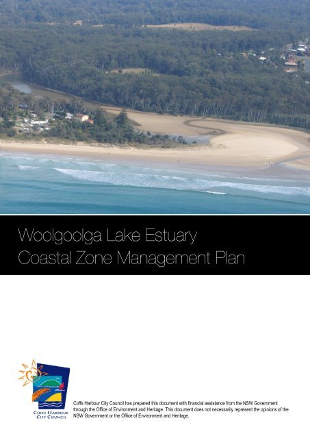
Woolgoolga Lake Estuary Coastal Zone Management Plan (7.9MB)
Woolgoolga Lake Estuary Coastal Zone Management Plan (7.9MB)
Woolgoolga Lake Estuary Coastal Zone Management Plan (7.9MB)

Create successful ePaper yourself
Turn your PDF publications into a flip-book with our unique Google optimized e-Paper software.
<strong>Woolgoolga</strong> <strong>Lake</strong> <strong>Estuary</strong><strong>Coastal</strong> <strong>Zone</strong> <strong>Management</strong> <strong>Plan</strong>Coffs Harbour City Council has prepared this document with financial assistance from the NSW Governmentthrough the Office of Environment and Heritage. This document does not necessarily represent the opinions of theNSW Government or the Office of Environment and Heritage.
This page has been left intentionally blank
<strong>Coastal</strong> <strong>Zone</strong><strong>Management</strong> <strong>Plan</strong><strong>Woolgoolga</strong> <strong>Lake</strong> <strong>Estuary</strong>Prepared for: Coffs Harbour City Council andOffice of Environment and Heritage© GeoLINK, 2013PO Box 119Lennox Head NSW 2478T 02 6687 7666PO Box 1446Coffs Harbour NSW 2450T 02 6651 7666info@geolink.net.au
Version HistoryUPR Description Date Issued Issued By Reviewed By1616692 Initial Draft 08/03/2012 Tim Ruge Garry Murray1616935 Final Draft 06/07/2012 Tim Ruge Cate Walsh1616614 Draft for Public Exhibition 30/08/2012 Tim Ruge Cate Walsh1616614 Draft for Public Exhibition-Rev1 07/11/2012 Tim Ruge Cate Walsh1616-1004 Final report 31/01/2013 Tim Ruge Kim Casson
13 Strategy 13 - Visual Amenity 6713.1 Summary of Proposed Actions ................................................................................................................... 6713.1.1 Related Strategies .................................................................................................................................. 6813.1.2 Objectives Addressed ............................................................................................................................. 6813.2 Details of Proposed Actions ........................................................................................................................ 6814 Strategy 14 - Dredging 7114.1 Summary of Proposed Actions ................................................................................................................... 7115 Strategy 15 - Residues from the 1989 Dieldrin/Aldrin Spill 7315.1 Summary of Proposed Actions ................................................................................................................... 7315.1.1 Related Strategies .................................................................................................................................. 73IllustrationsIllustration I.1 Illustration I1 Geographical Extent of the <strong>Coastal</strong> <strong>Zone</strong> <strong>Management</strong> <strong>Plan</strong> .............................. 2Illustration 1.1 Strategy 1 – Entrance <strong>Management</strong> ...................................................................................... 13Illustration 2.1 Modelled Nitrogen and Phosphorus Loads for <strong>Woolgoolga</strong> <strong>Lake</strong> by Land Use ................. 15Illustration 2.2 Landuse in the <strong>Woolgoolga</strong> <strong>Lake</strong> Catchment Area .............................................................. 16Illustration 2.3 Strategy 2 - Stormwater <strong>Management</strong> and Catchment Pollutants ...................................... 24Illustration 3.1 Strategy 3 – Foreshores and Riparian Areas........................................................................ 31Illustration 5.1 Strategy 5 - Climate Change Impacts on <strong>Estuary</strong> Ecology .................................................. 37Illustration 7.1 Strategy 7 – Aquatic Habitats ................................................................................................ 43Illustration 8.1 Strategy 8 – Environmental Weeds ....................................................................................... 49Illustration 11.1 Strategy 11 - Recreational Facilities and Opportunities ....................................................... 57Illustration 12.1 Strategy 12 - Flying-Fox Camp .............................................................................................. 65Illustration 13.1 Strategy 13 – Visual Amenity ................................................................................................. 70PlatesPlate 2.1 Future Growth Areas ....................................................................................................................... 20Plate 3.1 Southern Foreshore of <strong>Woolgoolga</strong> <strong>Lake</strong>....................................................................................... 26<strong>Coastal</strong> <strong>Zone</strong> <strong>Management</strong> <strong>Plan</strong> - <strong>Woolgoolga</strong> <strong>Lake</strong> <strong>Estuary</strong>1616-1004iii
ABCDEFEntrance <strong>Management</strong> Policy <strong>Woolgoolga</strong> <strong>Lake</strong> <strong>Estuary</strong><strong>Woolgoolga</strong> <strong>Lake</strong> Reserve Foreshores Upgrade - Design DevelopmentFunding SourcesSummary of <strong>Estuary</strong> Processes StudySummary of Community Uses AssessmentSummary of Development of <strong>Management</strong> Objectives and IssuesAppendices<strong>Coastal</strong> <strong>Zone</strong> <strong>Management</strong> <strong>Plan</strong> - <strong>Woolgoolga</strong> <strong>Lake</strong> <strong>Estuary</strong>1616-1004iv
Executive SummaryThis <strong>Coastal</strong> <strong>Zone</strong> <strong>Management</strong> <strong>Plan</strong> (CZMP) describes proposed actions to be implemented by CoffsHarbour City Council, other public authorities and the private sector to address priority management issuesfor the <strong>Woolgoolga</strong> <strong>Lake</strong> estuary. The area addressed by this CZMP comprises the <strong>Woolgoolga</strong> <strong>Lake</strong>waterway and tributaries, foreshores and the catchment draining to the estuary up to the tidal limit of thetributary creeks. The CZMP also considers issues associated with the wider catchment upstream of the tidallimit.<strong>Woolgoolga</strong> <strong>Lake</strong> is an Intermittently Closed and Open <strong>Lake</strong>s and Lagoon (ICOLL) meaning the entrancenaturally alternates between being open or closed to the ocean. The estuary is part of the Solitary IslandsMarine Park.The estuary has areas of high environmental, recreational and aesthetic value. A key focus of recreationalactivity occurs at the public picnic area adjacent to the <strong>Woolgoolga</strong> <strong>Lake</strong>side Holiday Park near the estuaryentrance. The close proximity of residential communities and the variety of natural settings around<strong>Woolgoolga</strong> <strong>Lake</strong> combine to create a broad range of passive land and water based recreationalopportunities that optimise the scenic potential of the area.The catchment area of <strong>Woolgoolga</strong> <strong>Lake</strong> includes a significant area of State Forest in the upper limits of thecatchment. Banana plantations and blueberry farms cover a significant proportion of the upper slopes in themid-catchment. Residential development and the commercial centre of <strong>Woolgoolga</strong> occupy a significantproportion of the lower catchment.Identification of key estuary management issues and development of management strategies has beenundertaken based on technical studies and consultation with the community and key stakeholderorganisations. Consultation has included community workshops in 2010 and 2011, a community survey in2011. The outcomes from community consultation for the 1991 <strong>Woolgoolga</strong> <strong>Lake</strong> <strong>Plan</strong> of <strong>Management</strong> havealso been considered.<strong>Estuary</strong> <strong>Management</strong> IssuesThe key estuary management issues for the estuary relate to: artificial opening of the estuary entrance to address flood mitigation and other issues while minimisinginterference with the natural opening and closing processes and associated estuary processes; management of sediment, nutrient and other pollutant inputs from the catchment; poorly managed recreational activities and land management practices have the potential to impact onriparian vegetation and also degrade the recreational experience and scenic / natural amenity of the lake; climate change impacts on the estuarine ecology and water quality (particularly as a result of sea levelrise and consequent lake water level increases); and the need to upgrade and manage existing recreational facilities and opportunities to enhance and protectthe recreational experience offered by <strong>Woolgoolga</strong> <strong>Lake</strong>.<strong>Estuary</strong> <strong>Management</strong> StrategiesA range of potential management strategies have been developed, prioritised and detailed to address the keyissues. These strategies are summarised in the following Implementation Schedule. The key managementstrategies include: formalising a policy for artificial opening of the entrance and minimising the need for artificial opening inthe long-term by active measures such as implementing flood mitigation measures for flood-risk propertiesand removing, relocating or otherwise managing items of low-lying infrastructure that currently necessitateopenings;<strong>Coastal</strong> <strong>Zone</strong> <strong>Management</strong> <strong>Plan</strong> - <strong>Woolgoolga</strong> <strong>Lake</strong> <strong>Estuary</strong>1616-1004v
continue educational and incentive schemes that address the management of soil resources and pesticide/ herbicide / fertiliser use in agricultural activities, encourage establishment of vegetated riparian zones onfarm watercourses, and ensure that best practice erosion control methods are applied during forestryoperations in the upper catchment; control significant land modification activities on rural lands by enforcing development consent whererequired under Council’s Local Environmental <strong>Plan</strong> to enforce erosion and sediment controls for significantearthworks; encourage the regeneration of riparian vegetation on the southern foreshores of the lake. This wouldinclude developing a landscape plan with the input of local landholders / residents and actively reestablishingriparian vegetation along sections of the foreshore reserve with due regard to the amenity ofadjoining residents; manage inappropriate mowing practices that impact on riparian vegetation using measures such asestablishing a defined maintenance boundary between riparian vegetation and mown grass areas at keylocations such as the foreshore residences on the southern foreshores of the lake and the foreshores ofthe <strong>Woolgoolga</strong> <strong>Lake</strong>side Reserve Picnic Area and <strong>Woolgoolga</strong> <strong>Lake</strong>side Caravan Park; implement development control provisions to facilitate upslope migration of mangroves and saltmarsh inresponse to sea level rise; maintain and consolidate the existing function and capacity of the <strong>Woolgoolga</strong> <strong>Lake</strong>side Reserve PicnicArea as the main focus for family, water and land based recreational activity around the lake (includingaddressing bank erosion). This includes constructing a foreshore platform to enhance water edgerecreational use and address bank erosion at the central and most popular section of the <strong>Lake</strong>sideReserve Picnic Area; and consolidate and upgrade walking trails around the lake, replace and rationalise the existing signagesystem, remove and revegetate unnecessary routes and provide a continuous walking track along thesouthern shore of the lake, Jarrett and <strong>Woolgoolga</strong> Creeks to formalise and enhance the recreationalexperience for public use.Dredging of the lake has been recommended by some community groups. Anecdotal evidence suggests thatthe estuary was previously deeper in the 1970’s. Community consultation has highlighted a perceived loss ofrecreational opportunity due to decreased waterway depth relative to this period. Historical aerialphotography indicates that water depths in 1943 were similar to present conditions, and deeper water depthswere experienced in the 1960’s and 1970’s. This is attributed to very large flooding events in combinationwith large ocean swell events during the 1960’s and 1970’s which had the effect of removing a significantamount of marine derived sediments near the entrance. Since the 1960’s and 1970’s marine derivedsediments have gradually built-up and subsequently reduced water depths in the vicinity of the lake picnicarea / lake entrance. Fluctuations in the amount of marine sediment in the estuary and consequentfluctuations in water depths are a natural trend.This estuary management study does not recommend dredging of <strong>Woolgoolga</strong> <strong>Lake</strong> for the purpose ofproviding deeper water depths on the basis of the following considerations: long-term fluctuations in water depths associated with infilling of the estuary by marine derived sands is anatural process that has occurred prior to the 1970’s; dredging is expensive and generally only achieves short-term benefits in respect to removal of sediment; dredging can have significant negative impacts on water quality, estuary processes, health, and ecology; the lake is part of the Solitary Islands Marine Park and is listed as ‘Habitat Protection <strong>Zone</strong>’ which has theobjective of protecting habitats and reducing high impact activities (e.g. dredging); and an approval process involving NSW government agencies is required before dredging is undertaken andit is considered unlikely that dredging would be approved for <strong>Woolgoolga</strong> <strong>Lake</strong> for the primary purpose ofincreasing water depths for improved swimming amenity.<strong>Coastal</strong> <strong>Zone</strong> <strong>Management</strong> <strong>Plan</strong> - <strong>Woolgoolga</strong> <strong>Lake</strong> <strong>Estuary</strong>1616-1004vi
Implementation ScheduleThe proposed management strategy actions are detailed in the following Implementation Schedule. Includedin the schedule is: the lead agency responsible for executing the strategy action (other relevant support agencies areincluded in the strategy action details in the main body of the CZMP); the timeframe for implementing the strategy action. The year relates to the time following adoption of thisCZMP e.g. “Years 2 – 5” indicates the strategy action should be implemented within 2 to 5 years ofadoption of the CZMP (refer to strategy action details in the main body of the CZMP with respect tomonitoring of each action); The strategy actions are listed in general order of priority with a specific priority assigned to each strategyaction in terms of “very high”, “high”, “medium” or “low” priority.Prior to implementation of the <strong>Woolgoolga</strong> <strong>Lake</strong> estuary strategy actions Council will need to review to ensureconsistency with the <strong>Coastal</strong> <strong>Zone</strong> <strong>Management</strong> <strong>Plan</strong> for the Coffs Harbour coastline and consistency withthe Regional Park <strong>Management</strong> <strong>Plan</strong>.<strong>Coastal</strong> <strong>Zone</strong> <strong>Management</strong> <strong>Plan</strong> - <strong>Woolgoolga</strong> <strong>Lake</strong> <strong>Estuary</strong>1616-1004vii
This page has been left intentionally blank
Implementation ScheduleStrategyActionNo.DescriptionLead Agency(refer to strategydetails for relatedagencies)Timeframe Cost Potential Funding Sources PriorityStrategy 1 - Entrance <strong>Management</strong>1.1 Prepare a Review of EnvironmentalFactors for artificial opening of theentrance to <strong>Woolgoolga</strong> <strong>Lake</strong>estuaryCHCC Year 1 Staff time CHCC operating budget High1.2 Refine, adopt and implement<strong>Woolgoolga</strong> <strong>Lake</strong> Entrance<strong>Management</strong> Policy1.3 Prepare a Floodplain Risk<strong>Management</strong> Study and <strong>Plan</strong> for<strong>Woolgoolga</strong> <strong>Lake</strong> and addressflooding risks that have the potentialto trigger artificial opening of theentranceCHCC Year 1 Staff time for adoption of policy. Internal costs associated withbackhoe, personnel andmonitoring / reporting for eachartificial opening event.CHCC Years 1 - 2 forFloodplain RiskStudy and <strong>Plan</strong> Years 2 – 5: auditand assessment Years 5 – 25:implementmeasures$100,000 for Floodplain Risk<strong>Management</strong> Study and <strong>Plan</strong> Audit and assessment:Council Staff time Implement measures:dependant on proposed worksCHCC operating budgetOEH Floodplain<strong>Management</strong> GrantsCHCC – Coffs HarbourWater budget for auditand assessment andsubsequentimplementation ofmeasures / augmentationworksHighMedium1.4 Raise community awareness of thenatural opening and closing regimeof <strong>Woolgoolga</strong> <strong>Lake</strong>CHCC Years 1 - 5 Included in the costs in StrategyAction 3.2 Caring for Our Country. CHCC Environmental Levy. OEH <strong>Coastal</strong> and <strong>Estuary</strong><strong>Management</strong> Program.Low<strong>Coastal</strong> <strong>Zone</strong> <strong>Management</strong> <strong>Plan</strong> - <strong>Woolgoolga</strong> <strong>Lake</strong> <strong>Estuary</strong>1616-1004ix
StrategyActionNo.DescriptionLead Agency(refer to strategydetails for relatedagencies)Timeframe Cost Potential Funding Sources PriorityStrategy 2 – Stormwater <strong>Management</strong> and Catchment Pollutants2.1 Educational strategies to addresssoil management and pesticide,herbicide and fertiliser use inagricultural activitiesDPI – AgricultureNSWYear 1$5,000 per workshop forpreparation, materials and delivery. Caring for Our Country CHCC Environmental Levy NRCMA OEH - EnvironmentalEducation GrantsHigh2.2 Encourage horticultural landownersto uptake incentives program forBest Practice <strong>Management</strong>NRCMA Years 1 – 5 Staff budget time forcoordinating uptake of theincentives program $20,000 pa for incentivesfunding from CHCCEnvironmental Levy $20,000 pa for incentivesfunding from NRCMA CHCC Environmental Levy NRCMA – Best Practice<strong>Management</strong> HorticulturalProgramVery High2.3 Best practice sediment, erosion andwater quality management onforestry operations in the catchmentDPI – ForestsNSWLife of the <strong>Plan</strong>$50,000 to $100,000 for auditingand monitoring of export waterquality.DPI and EPA – Forestsoperating budgetMedium2.4 Stormwater management for newurban developmentCHCCReview policy andguidelines every 5yearsPart of Council’s operational budget n/a Medium<strong>Coastal</strong> <strong>Zone</strong> <strong>Management</strong> <strong>Plan</strong> - <strong>Woolgoolga</strong> <strong>Lake</strong> <strong>Estuary</strong>1616-1004x
StrategyActionNo.DescriptionLead Agency(refer to strategydetails for relatedagencies)Timeframe Cost Potential Funding Sources Priority2.5 Stormwater management forexisting urban developmentCHCCInitial audit:Years 1 – 5Retrofit works:long term Stormwater management plan:$50 - $80k Retrofit works:dependant on proposed worksCHCC Environmental LevyMedium2.6 Encourage horticultural landownersto establish vegetated riparianzones on farm watercourses via theincentives program for Best Practice<strong>Management</strong>NRCMA Years 1 – 5 Part of cost listed in StrategyAction 2.2.Same funding as listed inStrategy Action 2.2.Very High2.7 Control land modification activitieson rural landsCHCC Year 1 Unknown additional staffingresources and additional costs toCouncil’s operational budgetn/aVery HighStrategy 3 - Foreshores and Riparian Areas3.1 Establish a defined edge betweenmown land and riparian vegetationalong the southern foreshore of<strong>Woolgoolga</strong> <strong>Lake</strong> adjacent toSunset <strong>Lake</strong>s Estate.CHCC Years 1 - 2 Establishment of defined edgeand initial re-establishment ofriparian vegetation: $5,000 <strong>Management</strong> / consultation: stafftime Landscape <strong>Plan</strong>: CHCC stafftime Caring for Our Country CHCC Environmental LevyVery High<strong>Coastal</strong> <strong>Zone</strong> <strong>Management</strong> <strong>Plan</strong> - <strong>Woolgoolga</strong> <strong>Lake</strong> <strong>Estuary</strong>1616-1004xi
StrategyActionNo.DescriptionLead Agency(refer to strategydetails for relatedagencies)Timeframe Cost Potential Funding Sources Priority3.2 Improve the extent of riparianvegetation along the southernforeshore of <strong>Woolgoolga</strong> <strong>Lake</strong>adjacent to Sunset <strong>Lake</strong>s Estate.CHCC Years 3 – 5 <strong>Plan</strong>ting works: $5,000 <strong>Management</strong> / consultation: stafftimeCHCC Environmental LevyHigh3.3 Modify the existing landscape planfor the <strong>Woolgoolga</strong> <strong>Lake</strong>sideReserve Picnic AreaCHCC Year 1 Landscape <strong>Plan</strong>: no cost -CHCC and DPI - Crown Landsstaff timeNot applicableHigh3.4 Establish a defined edge betweenmown land and riparian vegetationalong the foreshore of <strong>Woolgoolga</strong><strong>Lake</strong>side Reserve Picnic Area and<strong>Woolgoolga</strong> <strong>Lake</strong>side Caravan Parkand revegetate riparian areasCHCC as ReserveTrust ManagerYears 1 - 2 Establishment of defined edgeand initial re-establishment ofriparian vegetation: $5,000 CHCC Environmental LevyVery High3.5 Construct a foreshore platform toenhance water edge recreationaluse and address bank erosion atthe central and most popularsection of the <strong>Lake</strong>side ReservePicnic AreaCHCC Years 1 - 5 Foreshore structure 1 : $50,000 General site upgrades: newedging, paths, plants andsignage: $20,000 CHCC Environmental Levy Caring for Our CountryMedium3.6 Maintain and enhance other wateredge access points at <strong>Lake</strong>sideReserve Picnic Area.CHCC Years 1 - 5 $2,000 for any general siteupgrades CHCC Environmental LevyMedium<strong>Coastal</strong> <strong>Zone</strong> <strong>Management</strong> <strong>Plan</strong> - <strong>Woolgoolga</strong> <strong>Lake</strong> <strong>Estuary</strong>1616-1004xii
StrategyActionNo.DescriptionLead Agency(refer to strategydetails for relatedagencies)Timeframe Cost Potential Funding Sources PriorityStrategy 4 - Water Quality4.1 Minimise the input of domesticanimal faecal materials into thewaterway.Strategy 5 - Climate Change Impacts on <strong>Estuary</strong> EcologyCHCC Years 2 – 3 Staff time Installation of units $1,500 p/unit Maintenance of units $1000 perunit p/annumCaring for Our CountryMedium5.1 Implement development controlprovisions to facilitate upslopemigration of mangroves andsaltmarsh in response to sea levelriseCHCC Years 1 – 2 Staff time CHCC operating budget HighStrategy 6 – Fish Stocks - No direct fish stock improvement actions are proposed such as artificially stocking the lake. Other strategies and actions proposed in this CZMP willadequately address the issue of fish stocks. These strategies include: improve the extent and condition of aquatic habitat (Strategy 7 actions); improvethe condition and continuity of riparian vegetation (Strategy 3 and Strategy 8 actions) and improve water quality (Strategy 2 actions).Strategy 7 – Aquatic Habitats7.1 Liaise with landholders around theforeshore of <strong>Woolgoolga</strong> <strong>Lake</strong> toaddress impact to aquatic habitatsCHCC Years 1 - 5 Staff time CHCC operating budget. MPA - SIMP operatingbudgetHigh<strong>Coastal</strong> <strong>Zone</strong> <strong>Management</strong> <strong>Plan</strong> - <strong>Woolgoolga</strong> <strong>Lake</strong> <strong>Estuary</strong>1616-1004xiii
StrategyActionNo.DescriptionLead Agency(refer to strategydetails for relatedagencies)Timeframe Cost Potential Funding Sources Prioritytime such as EnvironmentalTrust Community BushRegeneration and/orRestoration and RehabilitationGrants.CHCC Environmental LevyStrategy 9 - Climate Change Impacts on Water Quality - Addressing current issues in accordance with Strategy Action 1.2 and Strategy 2 actions will be the best preparationfor the impacts of climate change on water quality. No further actions are proposed to address this issue.Strategy 10 - Water Quality Monitoring10.1 Continue to implement theEcohealth water quality monitoringprogram for <strong>Woolgoolga</strong> <strong>Lake</strong>CHCC Ongoing $20,000 every 4 years CHCC operating budget. MPA - SIMP: in kindassistanceMediumStrategy 11 - Recreational Facilities and Opportunities11.1 Maintain and improve facilities thatsupport existing passiverecreational activities at <strong>Woolgoolga</strong><strong>Lake</strong>side Reserve and along theforeshores of the <strong>Lake</strong>side CaravanPark.CHCC Years 1 - 5 Upgrade park furniture andsignage: $20,000 Visitor surveys: CHCC staff time Caring for Our Country Sport and RecreationFacility Grant programMedium<strong>Coastal</strong> <strong>Zone</strong> <strong>Management</strong> <strong>Plan</strong> - <strong>Woolgoolga</strong> <strong>Lake</strong> <strong>Estuary</strong>1616-1004xv
StrategyActionNo.Description11.2 Improve the path network aroundthe foreshores and tributaries of thelake11.3 Modify existing and proposed usesalong <strong>Lake</strong> Road to ensure thatenvironmental values are protected.11.4 Address Rubbish Around theForeshoresStrategy 12 - Flying-Fox Camp12.1 Ensure consistency between theFlying-fox management strategyand any related CZMP actionsLead Agency(refer to strategydetails for relatedagencies)Timeframe Cost Potential Funding Sources PriorityCHCC Years 5 – 10 Cycle path plan: CHCC staff. New signage system: $15,000. Upgraded tracks - north side$5,000. Upgraded tracks – south side:$20,000. High school path: $2,000. <strong>Lake</strong> mouth path: $2,000.<strong>Lake</strong> RoadReserve Trust<strong>Woolgoolga</strong>Beach ReserveTrustYears 1 – 5: $5,000 - create a barrier along<strong>Lake</strong> Road and restore clearedareas / manage Rainbow Bee-Eater nesting locationsCHCC Ongoing CHCC staff time for liaison,maintenance and Clean UpAustralia support Caring for Our Country. Sport and RecreationFacility Grant program. CHCC Environmental Levy Caring for Our Country. CHCC Environmental Levy. NRCMA.NSW Government LitterPrevention Program – grantsmanaged by the SustainabilityPrograms Division of OEHCHCC 1 – 2 years CHCC staff time for internal liaison. Nil HighMediumHighLow<strong>Coastal</strong> <strong>Zone</strong> <strong>Management</strong> <strong>Plan</strong> - <strong>Woolgoolga</strong> <strong>Lake</strong> <strong>Estuary</strong>1616-1004xvi
StrategyActionNo.DescriptionLead Agency(refer to strategydetails for relatedagencies)Timeframe Cost Potential Funding Sources PriorityStrategy 13 - Visual Amenity13.1 Preserve and enhance the naturalvalues of <strong>Woolgoolga</strong> <strong>Lake</strong> tomaintain its high level of visualamenity.CHCC 1 - 2 years Car tyre removal: $2,000assuming CHCC staff time Replace / modify timber wall:$5,000 assuming CHCC stafftime CHCC operating budget CHCC Environmental Levy.Medium -Low<strong>Coastal</strong> <strong>Zone</strong> <strong>Management</strong> <strong>Plan</strong> - <strong>Woolgoolga</strong> <strong>Lake</strong> <strong>Estuary</strong>1616-1004xvii
This page has been left intentionally blank
IntroductionThis document presents a <strong>Coastal</strong> <strong>Zone</strong> <strong>Management</strong> <strong>Plan</strong> (CZMP) for <strong>Woolgoolga</strong> <strong>Lake</strong> estuary. Theprimary purpose of this CZMP is to describe proposed actions to be implemented by Coffs Harbour CityCouncil, other public authorities and the private sector to address priority management issues for the<strong>Woolgoolga</strong> <strong>Lake</strong> estuary. These management issues relate to: risks to public safety and built assets; pressures on estuary health; and community uses of the estuary.The area addressed by this CZMP comprises the <strong>Woolgoolga</strong> <strong>Lake</strong> waterway and tributaries, foreshores andthe catchment draining to the estuary up to the tidal limit of the tributary creeks. The CZMP also considersissues associated with the wider catchment upstream of the tidal limit. The <strong>Woolgoolga</strong> <strong>Lake</strong> estuary isshown below and the extents of this area are mapped overleaf in Illustration I.1.Source: NSW Office of Environment and HeritagePlate I.1 Aerial Image of <strong>Woolgoolga</strong> <strong>Lake</strong> <strong>Estuary</strong>BackgroundIn 2010, Coffs Harbour City Council (Council) and Office of Environment and Heritage (OEH) engagedGeoLINK in association with Aquatic Science and <strong>Management</strong> and GECO Environmental to develop aCZMP for <strong>Woolgoolga</strong> <strong>Lake</strong> estuary. Council’s <strong>Coastal</strong> <strong>Estuary</strong> <strong>Management</strong> Advisory Committee’s goal forthe CZMP is to “to assist Council in achieving an integrated, balanced, responsible and ecologicallysustainable use of the <strong>Woolgoolga</strong> <strong>Lake</strong> <strong>Estuary</strong>.”<strong>Coastal</strong> <strong>Zone</strong> <strong>Management</strong> <strong>Plan</strong> - <strong>Woolgoolga</strong> <strong>Lake</strong> <strong>Estuary</strong>1616-10041
Information shown is for illustrative purposes onlyDrawn by: RE Checked by: MVE Reviewed by: TIM Date: April 2012Source of base data: Coffs Harbour City CouncilSAFTEY BEACHPacific HighwayCemetery Creek<strong>Woolgoolga</strong>High School Creek<strong>Woolgoolga</strong><strong>Lake</strong>Poundyard Creek<strong>Woolgoolga</strong>CreekJarrett CreekBeachWOOLGOOLGABeachBack<strong>Woolgoolga</strong>North0 300Geographical Extent of <strong>Coastal</strong> <strong>Zone</strong> <strong>Management</strong> <strong>Plan</strong><strong>Coastal</strong> <strong>Zone</strong> <strong>Management</strong> <strong>Plan</strong> - <strong>Woolgoolga</strong> <strong>Lake</strong> <strong>Estuary</strong>1616412Illustration I.1
Development of this CZMP has included the following preliminary phases: literature and information review;technical study of the relationship between the estuary processes, external influences and issues of concern;community uses assessment and development of key management objectives and issues. These preliminarystudies are reported in the following documents: Data Compilation and <strong>Estuary</strong> Processes Study – Darkum Creek, <strong>Woolgoolga</strong> <strong>Lake</strong> and Willis Creek(GeoLINK et al., 2011a); and <strong>Estuary</strong> <strong>Management</strong> Study – <strong>Woolgoolga</strong> <strong>Lake</strong> (GeoLINK et al., 2011b).Summaries of these preliminary phases are contained in: Appendix D – summary of literature and information review and technical study of estuary processes; Appendix E – summary of community uses assessment; and Appendix F – summary of development of key management objectives and issues.ConsultationCommunity and stakeholder consultation was undertaken to gain input to the development of managementaction for <strong>Woolgoolga</strong> <strong>Lake</strong> estuary. Consultation has included community workshops in 2010 and 2011, acommunity survey in 2011 and liaison with relevant stakeholders. The outcomes from communityconsultation for the 1991 <strong>Woolgoolga</strong> <strong>Lake</strong> <strong>Plan</strong> of <strong>Management</strong> have also been considered.Addressing <strong>Coastal</strong> <strong>Management</strong> PrinciplesThe notes below describe how this CZMP has considered the relevant <strong>Coastal</strong> <strong>Management</strong> Principles asdetailed in the Guideline for Preparing <strong>Coastal</strong> <strong>Zone</strong> <strong>Management</strong> <strong>Plan</strong>s (DECCW, 2010).Principle 1: The <strong>Plan</strong> will consider the objects of the <strong>Coastal</strong> Protection Act 1979 and the goals, objectivesand principles of the NSW <strong>Coastal</strong> Policy 1997 and the NSW Sea Level Rise Policy Statement 2009.The NSW <strong>Coastal</strong> Policy deals with population and economic growth whilst protecting the natural, cultural,heritage and spiritual values of the coastal environment. The policy has a strong focus on the principles ofEcologically Sustainable Development. The NSW <strong>Coastal</strong> Protection Act 1979 aims to protect, enhance,maintain and restore the environment with concern for both the natural and built environments. Theseprinciples formed the basis of development and prioritisation of management strategies for <strong>Woolgoolga</strong> <strong>Lake</strong>estuary.The benchmarks and guidelines in the NSW Sea Level Rise Policy Statement 2009 have been considered indevelopment of the entrance management policy, and in relation to climate change impacts on estuaryecology, hydrodynamics and community infrastructure.Principle 2: Optimise links between plans relating to the management of the coastal zone.Development of this CZMP including the literature review component has considered Council’s <strong>Coastal</strong>Processes and Hazard Definition Study and <strong>Coastal</strong> <strong>Zone</strong> <strong>Management</strong> Study for the coastline, Council’sClimate Change Mitigation and Adaptation Action <strong>Plan</strong> and other studies and management plans related to<strong>Woolgoolga</strong> <strong>Lake</strong> estuary.Principle 3: Involve the community in decision-making and make coastal information publicly available.As indicated above, community consultation was undertaken to gain input to the development of managementaction for <strong>Woolgoolga</strong> <strong>Lake</strong> estuary including community workshops in 2010 and 2011, and a communitysurvey in 2011 and liaison with relevant stakeholders. The outcomes from community consultation for the1991 <strong>Woolgoolga</strong> <strong>Lake</strong> <strong>Plan</strong> of <strong>Management</strong> have also been considered.<strong>Coastal</strong> <strong>Zone</strong> <strong>Management</strong> <strong>Plan</strong> - <strong>Woolgoolga</strong> <strong>Lake</strong> <strong>Estuary</strong>1616-10043
Principle 4: Base decisions on the best available information and reasonable practice; acknowledge theinterrelationship between catchment, estuarine and coastal processes; adopt a continuous improvementmanagement approach.The estuary processes study component of the CZMP considered the above issues. Development ofmanagement strategies has included a continuous improvement management approach such as themeasures outlined in the entrance management strategy to minimise the future need for artificial openingevents.Principle 5: The priority for public expenditure is public benefit; public expenditure should cost effectivelyachieve the best practical long-term outcomes.Development of strategies and priorities has included consideration of public expenditure.Principle 6: Adopt a risk management approach to managing risks to public safety and assets; adopt a riskmanagement hierarchy involving avoiding risks where feasible and mitigation where risks cannot bereasonably avoided; adopt interim actions to manage high risks while long-term options are implemented.This principle is not directly applicable to the issues for the <strong>Woolgoolga</strong> <strong>Lake</strong> estuary.Principle 7: Adopt an adaptive risk management approach if risks are expected to increase over time, or toaccommodate uncertainty in risk predictions.This principle is not directly applicable to the issues for the <strong>Woolgoolga</strong> <strong>Lake</strong> estuary.Principle 8: Maintain the condition of high value coastal ecosystems; rehabilitate priority degraded coastalecosystems.Development and prioritisation of strategies has considered the above approach such as management ofenvironmental weeds which has been prioritised for riparian vegetation classified as either ‘good’ or ‘verygood’ condition.Principle 9: Maintain and improve safe public access to beaches and headlands consistent with the goals ofthe NSW <strong>Coastal</strong> Policy.This principle is not directly applicable to the issues for the <strong>Woolgoolga</strong> <strong>Lake</strong> estuary, however, actions underStrategy 11 address a key public access location for swimming and canoeing in <strong>Woolgoolga</strong> <strong>Lake</strong>.Principle 10: Support recreational activities consistent with the goals of the NSW <strong>Coastal</strong> Policy.Strategy 11 in this CZMP directly addresses recreational activities related to <strong>Woolgoolga</strong> <strong>Lake</strong> estuary.<strong>Coastal</strong> <strong>Zone</strong> <strong>Management</strong> <strong>Plan</strong> - <strong>Woolgoolga</strong> <strong>Lake</strong> <strong>Estuary</strong>1616-10044
Key Values of <strong>Woolgoolga</strong> <strong>Lake</strong> <strong>Estuary</strong>The natural settings of the estuaries and coast within the Mid North Coast are a feature that attracts visitorsand locals to the area. <strong>Woolgoolga</strong> <strong>Lake</strong> estuary is in keeping with this natural setting, and forms part of anetwork of bushland settings along the coastal zone of the Coffs Harbour region.Key values of the estuary include its natural setting and recreational opportunities including the public picnicarea adjacent to the lake and the walking and cycling track network. A key focus of recreational activityoccurs at the public picnic area adjacent to the <strong>Woolgoolga</strong> <strong>Lake</strong>side Holiday Park. The area has a long openforeshore that allows easy, soft water entry for swimming and canoe / kayak launching.The close proximity of residential communities and the variety of natural settings around <strong>Woolgoolga</strong> <strong>Lake</strong>combine to create a broad range of passive land and water based recreational opportunities that optimise thescenic potential of the area. The sites attributes create a highly attractive and popular recreation destinationfor the local and wider community.The majority of the foreshores around the lake comprise a continuous edge of natural vegetation, oftenextending well back from the foreshores and rising up adjoining slopes. This mostly intact and healthy riparianvegetation contributes significantly to the value and health of the estuary.Water quality in the lake shows high levels of variability common to this type of estuary. However, the waterquality is generally acceptable for primary contact recreation and protection of aquatic ecosystems.The entrance to the <strong>Woolgoolga</strong> <strong>Lake</strong> estuary naturally alternates between being open or closed to theocean. These types of estuaries are known as an ICOLL’s - Intermittently Closed and Open <strong>Lake</strong>s andLagoons.Key <strong>Management</strong> IssuesThe key estuary management issues that have been identified relate to: the estuary entrance which naturally alternates between being open or closed to the ocean. The issuerelates to artificial opening of the entrance to address flood mitigation while minimising interference withthe natural opening and closing regime and associated estuary processes; sediment, nutrient and other pollutant inputs from the catchment; recreational activities and other practices that have the potential to impact on riparian vegetation anddegrade the recreational experience and scenic / natural amenity of the lake; climate change impacts (particularly sea level rise and consequent lake water level increases) on theestuarine ecology and water quality; and the need to upgrade and manage existing recreational facilities and opportunities to enhance andprotect the recreational experience offered by <strong>Woolgoolga</strong> <strong>Lake</strong>.Key <strong>Management</strong> StrategiesKey management strategies for <strong>Woolgoolga</strong> <strong>Lake</strong> estuary include: adoption of an entrance management policy that addresses flood mitigation issues but minimisesinterference with the natural opening and closing regime of the lake. The entrance managementstrategy also includes minimising the need for artificial entrance opening in the long-term by activemeasures such as removing flooding risks to low-lying infrastructure; a range of actions addressing soil erosion, stormwater management and pesticide / herbicide / fertiliseruse in agricultural activities; undertaking better maintenance practices and restoring riparian vegetation in poorly or inappropriatelymaintained areas such as the southern foreshores of the lake;<strong>Coastal</strong> <strong>Zone</strong> <strong>Management</strong> <strong>Plan</strong> - <strong>Woolgoolga</strong> <strong>Lake</strong> <strong>Estuary</strong>1616-10045
maintain and consolidate the existing function and capacity of the lakeside picnic area as the main focusfor family, water and land based recreational activity around the lake while addressing issues that impacton bank erosion and riparian vegetation; andconsolidate and upgrade walking trails around the lake, remove and revegetate unnecessary routes andother works required to formalise and enhance the recreational experience for public use.The management strategies in this document are presented in general order of priority (Strategy 1 being thehighest priority). Specific priorities have also been assigned to each strategy action in terms of “very high”,“high”, “medium” or “low” priority. The priorities and timeframes provided in this CZMP are indicative and areto be used to guide the order of implementation. Priorities were established in response to: the degree to which the management strategies will impact on estuary issues; timeframe over which the strategy impacts will extend (the longer the better); extent of the estuary addressed by each management strategy; community rating of issues addressed by each management strategy (based on a community survey);and the likely cost of effective implementation of the management strategy.Coffs Harbour 2030 <strong>Plan</strong>The Coffs Harbour 2030 <strong>Plan</strong> (CHCC, 2009), a strategic plan for the Coffs Harbour community (‘the 2030<strong>Plan</strong>’), was adopted by Council in December 2009. The 2030 <strong>Plan</strong> is driven by the Community Vision 2030and outlines the steps needed to create a sustainable future for Coffs Harbour LGA. It is the overarching planthat integrates planning and reporting frameworks, while mapping out the community’s aspirations for thefuture of the Coffs Harbour LGA to 2030 and beyond.This CZMP is consistent with the aspirations of the Coffs Harbour community as articulated in the 2030 <strong>Plan</strong>.The 2030 <strong>Plan</strong> covers five themes including Moving Around and Looking after our Environment which aremore directly applicable to this CZMP. The 2030 <strong>Plan</strong> outlines outcomes, objectives and actions for eachtheme. The actions applicable to this CZMP are listed in Table I.1 below. The final two columns of the tablelist the CZMP strategy actions that address the listed 2030 <strong>Plan</strong> strategies.Table I.1 – Coffs Harbour 2030 <strong>Plan</strong>Coffs Harbour 2030 <strong>Plan</strong>Related CZMP StrategyOutcome Objective Strategy Strategy DescriptionAction No.MA2 Many of uswalk and cyclefrom place toplaceMA 2.2.1 Work inpartnership to provide cycleways and footpaths.11.2LE1 Weunderstand andvalue our uniquenaturalenvironment andits culturalconnectionsMA2.2 We haveconstructed aninterconnected network ofcycle ways, footpaths andwalking tracks thatconnect our urbancommunities, hinterlandand coastal villages.LE1.3 We have manyopportunities for natureexperiences and learningthrough improved accessto natural areas.LE1.3.1 Promoteconnection to theenvironment throughlearning in the environment.LE1.3.2 Create and extendwalking trails and otheropportunities forenvironmental experiences.3.111.111.23.511.2Improve the pathnetwork around theforeshores andtributaries of the lakePotential future pathalong southernforeshoreInterpretive signageConstruct foreshoreplatformImprove the pathnetwork around theforeshores and<strong>Coastal</strong> <strong>Zone</strong> <strong>Management</strong> <strong>Plan</strong> - <strong>Woolgoolga</strong> <strong>Lake</strong> <strong>Estuary</strong>1616-10046
Coffs Harbour 2030 <strong>Plan</strong>Outcome Objective Strategy StrategyAction No.LE2 We protectand restore ourenvironment toconserve itsuniquebiodiversity forfuture generationsLE2.1 Our forests,beaches, headlands,ocean, rivers, forestedmountain backdrop,plants and animals areconserved for futuregenerations.LE2.2 We have activeprograms to restore andimprove our environment.LE2.1.1 Ensure land usemanagement policies andpractices conserve theregion’s uniqueenvironmental andbiodiversity values.LE2.1.2 Enhance protectionof our marine areas andmanage for change.LE2.1.3 Maintain andconserve biodiversitythrough protected reservesystems and other landconservation mechanisms.LE2.1.5 Implement climatechange planning,adaptation and mitigationstrategies.LE2.2.2 Manage ourcatchments effectively andadaptably.<strong>Coastal</strong> <strong>Zone</strong> <strong>Management</strong> <strong>Plan</strong> - <strong>Woolgoolga</strong> <strong>Lake</strong> <strong>Estuary</strong>1616-1004Related CZMP StrategyStrategy 2actionsStrategy 3actionsStrategy 8actions11.312.1As abovewith respectto Strategy2 and 35.15.112.11.35.1Strategy 2actionsDescriptiontributaries of the lakeBest Practice<strong>Management</strong> for soilmanagement andpesticide, herbicideand fertiliser use inagricultural activitiesand forestryoperationsUrban stormwatermanagement<strong>Management</strong> offoreshores andriparian vegetationEnvironmental weedstrategyModify uses along<strong>Lake</strong> Road to ensureenvironmental valuespredominateEnsure consistencywith Flying-foxmanagementstrategyAs above withrespect to Strategy 2and 3 actionsBuffers to enableaquatic habitats torespond to sea levelriseBuffers to enableaquatic habitats torespond to sea levelriseEnsure consistencywith Flying-foxmanagementstrategyAddress increasedflooding risks that willimpact on artificialentrance openingsBuffers to enableaquatic habitats torespond to sea levelriseBest Practice<strong>Management</strong> for soilmanagement andpesticide, herbicideand fertiliser use inagricultural activitiesand forestry7
Coffs Harbour 2030 <strong>Plan</strong>Outcome Objective Strategy StrategyAction No.LE3 We manageour resources anddevelopmentsustainably.LE3.1 We are responsiblein the use andmanagement of ournatural resources andwork to reduce ourecological footprint.LE2.2.3 Build ecosystemresilience through a systemof local and regional habitatcorridors.LE3.1.2 Use best practiceto prevent pollution impactson our environment.Related CZMP StrategyStrategy 3actions5.1Strategy 2actionsDescriptionoperationsUrban stormwatermanagement<strong>Management</strong> offoreshores andriparian vegetationBuffers to enableaquatic habitats torespond to sea levelriseBest Practice<strong>Management</strong> for soilmanagement andpesticide, herbicideand fertiliser use inagricultural activitiesand forestryoperationsUrban stormwatermanagementCoffs Harbour <strong>Coastal</strong> <strong>Zone</strong> <strong>Management</strong> <strong>Plan</strong>Council is preparing a separate <strong>Coastal</strong> <strong>Zone</strong> <strong>Management</strong> <strong>Plan</strong> that addresses coastal risks along the CoffsHarbour coastline. This coastline plan will define the level of risk from coastal hazards and provide a coordinatedapproach to management of coastal hazards.Initial review of draft actions proposed in the coastline plan does not indicate any inconsistencies with the<strong>Woolgoolga</strong> <strong>Lake</strong> estuary strategy actions. However, prior to implementation of the <strong>Woolgoolga</strong> <strong>Lake</strong> estuarystrategy actions Council will need to review to ensure consistency with the <strong>Coastal</strong> <strong>Zone</strong> <strong>Management</strong> <strong>Plan</strong>for the Coffs Harbour coastline.Coffs Harbour Regional Park <strong>Management</strong> <strong>Plan</strong>Council is also preparing a Regional Park <strong>Management</strong> <strong>Plan</strong>. Prior to implementation of the <strong>Woolgoolga</strong><strong>Lake</strong> estuary strategy actions Council will need to review to ensure consistency with the Regional Park<strong>Management</strong> <strong>Plan</strong>.<strong>Coastal</strong> <strong>Zone</strong> <strong>Management</strong> <strong>Plan</strong> - <strong>Woolgoolga</strong> <strong>Lake</strong> <strong>Estuary</strong>1616-10048
1111Strategy 1 - Entrance <strong>Management</strong>The entrance to the <strong>Woolgoolga</strong> <strong>Lake</strong> estuary naturally alternates between being open or closed to theocean. These types of estuaries are known as an ICOLL’s - Intermittently Closed and Open <strong>Lake</strong>s andLagoons.Many ICOLL’s are manually or artificially opened to the ocean by authorities to ‘drain’ the estuary for a rangeof reasons, often to reduce the impacts of flooding around the estuary foreshores. Artificial opening of the<strong>Woolgoolga</strong> <strong>Lake</strong> entrance has been initiated in the past by Council to prevent flooding of the adjoiningsewerage system.However, artificially opening ICOLL’s can impact on the health of the estuary. Therefore it is desirable tominimise interference with the natural opening and closing regime of ICOLL’s. Therefore a policy is requiredto outline if and when the entrance to <strong>Woolgoolga</strong> <strong>Lake</strong> estuary should be artificially opened.1.1 Summary of Proposed ActionsPrepare a Review of Environmental Factors for artificial opening of the entrance to <strong>Woolgoolga</strong> <strong>Lake</strong>estuary;Refine, adopt and implement the <strong>Woolgoolga</strong> <strong>Lake</strong> Entrance <strong>Management</strong> Policy outlined in this CZMP;Prepare a Floodplain Risk <strong>Management</strong> Study and <strong>Plan</strong> for <strong>Woolgoolga</strong> <strong>Lake</strong> and address flooding risksthat have the potential to trigger artificial opening of the entrance; andRaise community awareness of the natural opening and closing regime of <strong>Woolgoolga</strong> <strong>Lake</strong>.1.1.1 Related StrategiesStrategy 2 Stormwater <strong>Management</strong> and Catchment PollutantsStrategy 4 Water QualityStrategy 6 Fish StocksStrategy 7 Aquatic HabitatsStrategy 9 Climate Change and Sea Level Rise Impacts on Water QualityStrategy 14 Dredging1.1.2 Objectives AddressedDevelop a formal Entrance <strong>Management</strong> Policy;Minimise interference with natural entrance opening / closing processes; andMinimise flooding of properties and infrastructure.<strong>Coastal</strong> <strong>Zone</strong> <strong>Management</strong> <strong>Plan</strong> - <strong>Woolgoolga</strong> <strong>Lake</strong> <strong>Estuary</strong>1616-10049
1.2 Details of Proposed ActionsStrategy Action 1.1Prepare a Review of Environmental Factors for artificial opening of the entrance to <strong>Woolgoolga</strong> <strong>Lake</strong> estuaryBackground:Artificial opening of the entrance to <strong>Woolgoolga</strong> <strong>Lake</strong> estuary for the purpose of flood mitigation (a keyobjective of the entrance management policy) is permitted without consent under Clause 50 of the StateEnvironmental <strong>Plan</strong>ning Policy (Infrastructure), 2007. However the requirements of Part 5 of the EP&A Act1979 must be fulfilled and Council is required to prepare a Review of Environmental Factors (REF) forproposed artificial opening of the entrance to <strong>Woolgoolga</strong> <strong>Lake</strong> estuary. The REF needs to be consistent withthe adopted CZMP and entrance management policy for <strong>Woolgoolga</strong> <strong>Lake</strong> estuary.Specific TasksPrepare an REF for artificial opening of the entrance to <strong>Woolgoolga</strong> <strong>Lake</strong> estuary in consultation with relevantstate government agencies. The REF will confirm the necessary approvals and licences required for artificialopening of the entrance.ResponsibleAgenciesTimeframe 1 Cost Potential FundingSourcesMonitoringCHCC Year 1 Staff time CHCC operatingbudgetStrategy Action 1.2Refine, adopt and implement <strong>Woolgoolga</strong> <strong>Lake</strong> Entrance <strong>Management</strong> PolicyImplementation ofthis action is anappropriatebenchmark.Background:The development of an entrance management policy is a requirement for <strong>Coastal</strong> <strong>Zone</strong> <strong>Management</strong> <strong>Plan</strong>s forICOLL’s under the OEH Guidelines for Preparing <strong>Coastal</strong> <strong>Zone</strong> <strong>Management</strong> <strong>Plan</strong>s (DECCW, 2010).Therefore a policy has been drafted with the aim to: minimise interference with the natural opening and closing regime for the estuary; minimise flooding of the local sewerage system from elevated water levels in the estuary; and minimise flooding of properties from elevated water levels in the estuary.Specific Tasks Refine the <strong>Woolgoolga</strong> <strong>Lake</strong> Entrance <strong>Management</strong> Policy outlined in this CZMP (refer to Appendix A)based on the outcomes of the REF under Strategy Action 1.1. Adopt and implement the <strong>Woolgoolga</strong> <strong>Lake</strong> Entrance <strong>Management</strong> Policy.ResponsibleAgenciesTimeframe 1 Cost Potential FundingSourcesCHCC Year 1 Staff time foradoption of policy. Internal costsassociated withbackhoe, personneletc for each artificialopening event.<strong>Coastal</strong> <strong>Zone</strong> <strong>Management</strong> <strong>Plan</strong> - <strong>Woolgoolga</strong> <strong>Lake</strong> <strong>Estuary</strong>1616-1004CHCC operatingbudgetMonitoringImplementation ofthis action is anappropriatebenchmark.10
Strategy Action 1.3Prepare a Floodplain Risk <strong>Management</strong> Study and <strong>Plan</strong> for <strong>Woolgoolga</strong> <strong>Lake</strong> and address flooding risks thathave the potential to trigger artificial opening of the entranceBackground:The current need for artificial opening of the entrance is largely dictated by the need to prevent flooding of lowlyingproperties such as Sunset Caravan Park and properties in Pacific Street, Wharf Street, Boundary Streetand Haines Close. This necessitates opening the lake entrance when lake water levels reach 1.6 m AHDwhich is at the higher end of the range of water levels at which the lake opens naturally. Therefore the policyto open at 1.6 m AHD will generally not impact on the natural opening and closing regime of the lake entrance.However, as sea level rise is realised, the lake water levels will rise by similar values as will the naturalbreakout levels of the lake. This will potentially result in the 1.6 m AHD trigger water level encroaching into thenatural breakout levels thereby impacting on the natural opening and closing regime of the lake entrance.Therefore it may be necessary to raise the trigger level in the future by a similar amount as sea level rise.It is noted that the local sewerage scheme experiences flooding at lake water levels of 1.8 m AHD.The trigger water level for artificial opening can be raised in the future by implementing flood mitigationmeasures for at-risk properties and items of low-lying infrastructure. The intention of this objective is tominimise the need for interference to the natural opening / closing regime of the lake entrance.Specific Tasks Prepare a Floodplain Risk <strong>Management</strong> Study and <strong>Plan</strong> for <strong>Woolgoolga</strong> <strong>Lake</strong> which addresses theobjective of minimising interference to the natural opening / closing regime of the lake entrance; In association with Council’s Climate Change Mitigation and Adaptation Action <strong>Plan</strong> (BMT WBM, 2010):- undertake an audit and assessment to identify key services and assets vulnerable to sea level riseimpacts around <strong>Woolgoolga</strong> <strong>Lake</strong> which have the potential to necessitate artificial opening of the lakeentrance (e.g. sewer PS 1 and PS 16 and low-lying properties). Develop appropriate strategies forrelocation, replacement or modification of these services and assets (this relates to Action A-3 and A-4 in Council’s Climate Change Mitigation and Adaptation Action <strong>Plan</strong>);- relocate, replace or modify essential services and assets where appropriate to reduce potential fordisruption and/or the need for artificial opening of the entrance (this relates to Action A-7 in Council’sClimate Change Mitigation and Adaptation Action <strong>Plan</strong>).ResponsibleAgenciesCHCCTimeframe 1 Cost Potential FundingSources Years 1 - 2 forFloodplain Risk<strong>Management</strong>Study and <strong>Plan</strong> Years 2 - 5 foraudit andassessment Years 5 – 25implementmeasures $100,000 forFloodplain Risk<strong>Management</strong> Studyand <strong>Plan</strong> Audit andassessment:Council Staff time Implementmeasures:dependant onproposed works OEH Floodplain<strong>Management</strong>Grants CHCC – CoffsHarbour Waterbudget for audit& assessmentand subsequentimplementationof measures /augmentationworksMonitoringImplementation ofthis action is anappropriatebenchmark<strong>Coastal</strong> <strong>Zone</strong> <strong>Management</strong> <strong>Plan</strong> - <strong>Woolgoolga</strong> <strong>Lake</strong> <strong>Estuary</strong>1616-100411
Strategy Action 1.4Raise community awareness of the natural opening and closing regime of <strong>Woolgoolga</strong> <strong>Lake</strong>Specific TasksTo assist with establishing broad based community understanding and support for the entrance managementpolicy for <strong>Woolgoolga</strong> <strong>Lake</strong> it is recommended that information on the natural opening and closing regime of<strong>Woolgoolga</strong> <strong>Lake</strong> is included in the interpretive centre proposed under Strategy Action 3.2 (Strategy 3).ResponsibleAgenciesTimeframe 1 Cost Potential FundingSourcesMonitoringCHCC Years 1 - 5 Included in the costs inStrategy Action 3.2 Caring for OurCountry. CHCCEnvironmentalLevy. OEH <strong>Coastal</strong>and <strong>Estuary</strong><strong>Management</strong>Program.Implementation ofthis action is anappropriatebenchmark.Note: 1. Timeframe: the year relates to the time following adoption of this CZMP eg. “Years 2 – 5” indicates the strategy action shouldbe implemented within 2 to 5 years of adoption of the CZMP<strong>Coastal</strong> <strong>Zone</strong> <strong>Management</strong> <strong>Plan</strong> - <strong>Woolgoolga</strong> <strong>Lake</strong> <strong>Estuary</strong>1616-100412
Information shown is for illustrative purposes onlyDrawn by: RE Checked by: TIM Reviewed by: TIM Date: October 2012Source of base data: Coffs Harbour City CouncilCampbell StreetApproximate location for artificial opening<strong>Woolgoolga</strong><strong>Lake</strong>EntranceCemetery CreekAccess route for artificial openingHigh School Creek<strong>Woolgoolga</strong><strong>Lake</strong>Sewer pump station 16<strong>Lake</strong> Road<strong>Lake</strong> water level recorder<strong>Woolgoolga</strong> BeachHaines Close<strong>Woolgoolga</strong>SunsetCaravanParkCreekPacific StreetGanderton StreetWharf StreetBoundary StreetJarrett CreekBeach StreetSewer pump station 1WOOLGOOLGANorth0 200<strong>Coastal</strong> <strong>Zone</strong> <strong>Management</strong> <strong>Plan</strong> - <strong>Woolgoolga</strong> <strong>Lake</strong> <strong>Estuary</strong>1616812Strategy 1 - Entrance <strong>Management</strong>Illustration 1.1
This page has been left intentionally blank
2222Strategy 2 – Stormwater <strong>Management</strong> andCatchment PollutantsCatchment inputs in the form of stormwater, diffuse runoff and point source inputs are typically the majorsources of poor water quality in estuaries and other coastal water bodies. The effects of poor water qualityinputs can be magnified in ICOLLs such as <strong>Woolgoolga</strong> <strong>Lake</strong> depending on the status of the entrance.An overview of the various land uses in the <strong>Woolgoolga</strong> <strong>Lake</strong> catchment is shown overleaf in Illustration 2.2.Stormwater and catchment pollutant modelling undertaken during the <strong>Woolgoolga</strong> <strong>Lake</strong> <strong>Estuary</strong> ProcessesStudy (EPS) suggests that forestry operations in the upper catchment has the potential to be the majorsource of sediment and nitrogen inputs to the estuary (refer to Illustration 2.1). It also suggests thatphosphorus input is dominated by agricultural land uses. Careful management of both of these activitieswithin the catchment may lead to long term improvements in water quality.TN Load (kg/year)800070006000500040003000200010000TP Load (kg/year)120010008006004002000<strong>Woolgoolga</strong> Lower<strong>Woolgoolga</strong> UpperPoundyardIllustration 2.1 Modelled Nitrogen and Phosphorus Loads for <strong>Woolgoolga</strong> <strong>Lake</strong> by Land UseCommunity consultation indicates concern regardingpesticide and herbicide runoff from agricultural activities(mostly blueberry and banana farming and hothousehorticulture). Guidelines for best practice management ofsoil and water resources on blueberry (NSW DPI 2008a)and banana farms (NSW DPI 2008b) are available andhave been used in the study area in the past as a basisfor workshops and training activities for farmers.Of a more direct nature, investigation of a fish kill led to aprosecution of a <strong>Woolgoolga</strong> resident accused of dumping pesticides (dieldrin and aldrin) directly into<strong>Woolgoolga</strong> Creek. This specific issue is addressed in Strategy 15.There have also been occasions when sewage infrastructure has flooded leading to direct inputs of untreatedsewage into the waterway.<strong>Coastal</strong> <strong>Zone</strong> <strong>Management</strong> <strong>Plan</strong> - <strong>Woolgoolga</strong> <strong>Lake</strong> <strong>Estuary</strong>1616-100415
Information shown is for illustrative purposes onlyDrawn by: RE Checked by: MVE Reviewed by: TIM Date: June 2012Source of base data: Coffs Harbour City CouncilL E G E N DAgricultureUrbanBusinessIndustrialCommunity purposeOpen space recreationEnvironmental protectionNorth0 600Landuse in the <strong>Woolgoolga</strong> <strong>Lake</strong> Catchment Area<strong>Coastal</strong> <strong>Zone</strong> <strong>Management</strong> <strong>Plan</strong> - <strong>Woolgoolga</strong> <strong>Lake</strong> <strong>Estuary</strong>1616169Illustration 2.2
2.1 Summary of Proposed ActionsEducational strategies to address soil management and pesticide, herbicide and fertiliser use inagricultural activities.Encourage horticultural landowners to uptake incentives program for Best Practice <strong>Management</strong>.Best practice sediment, erosion and water quality management on forestry operations in the catchment.Stormwater management for new urban development.Stormwater management for existing urban development.Encourage horticultural landowners to establish vegetated riparian zones on farm watercourses via theincentives program for Best Practice <strong>Management</strong>.Control land modification activities on rural lands.2.1.1 Related StrategiesStrategy 1 Entrance <strong>Management</strong>.Strategy 4 Water Quality.Strategy 6 Fish Stocks.Strategy 7 Aquatic Habitats.Strategy 9 Climate Change and Sea Level Rise Impacts on Water Quality.Strategy 10 Water Quality Monitoring.Strategy 15 Residues from the 1989 Dieldrin/Aldrin Spill.2.1.2 Objectives AddressedImprove the condition and extent of aquatic habitats.Make provisions for the ecological effects of climate change and sea level rise.Improved water quality.2.2 Details of Proposed ActionsStrategy Action 2.1Educational strategies to address soil management and pesticide, herbicide and fertiliser use in agriculturalactivitiesBackground:Community consultation indicates concern that agricultural activities (mostly blueberry and banana farming andhothouse horticulture) may be negatively impacting water quality in <strong>Woolgoolga</strong> <strong>Lake</strong> via inputs of sediment,nutrients and agricultural chemicals.A campaign of awareness targeting rural landholders is considered an appropriate way of addressing theseconcerns, improving agricultural practices and having a positive effect on water quality in <strong>Woolgoolga</strong> <strong>Lake</strong>.Workshops run by Coffs Harbour Regional Landcare in 2011 (Coffs Harbour Landcare 2011) targeting fertiliseruse on blueberry farms are an example of recent initiatives that could be expanded upon. Workshops could bebased upon existing guidelines (NSW DPI 2008a & b) and utilise the expertise of NSW DPI (Agriculture) stafffrom the Coffs Harbour region. In order to achieve the best outcomes for waterways the workshops shouldfocus on best practice soil management and chemical use.Specific TasksDevelop and deliver a series of workshops aimed at blueberry and banana farmers in the catchment thatdescribe: strategies to reduce erosion, such as contour alignment of rows, installation of trafficable cross banks at<strong>Coastal</strong> <strong>Zone</strong> <strong>Management</strong> <strong>Plan</strong> - <strong>Woolgoolga</strong> <strong>Lake</strong> <strong>Estuary</strong>1616-100417
egular intervals, establishment of groundcovers, adequate riparian buffer widths on rural properties andthe use of subsurface drainage;strategies to maintain and monitor soil moisture such that irrigation is always used in the most efficientmanner;strategies to maximise the efficiency of fertiliser, herbicide and pesticide use and application, such thatthe overall use is minimised and concentrations in runoff can be minimised; andstrategies to minimise the risk of accidental spillage of fertiliser, herbicides and pesticides such asappropriate storage, transport and disposal.ResponsibleAgenciesTimeframe Cost Potential FundingSourcesMonitoringLead Agency: DPI - –Agriculture NSWRelated Agencies: CHCC; NRCMA; Landcare.Year 1$5,000 perworkshop forpreparation,materials anddelivery. Caring for OurCountry CHCCEnvironmentalLevy NRCMA OEH -EnvironmentalEducationGrantsDelivery ofworkshops is anappropriatebenchmark.Strategy Action 2.2Encourage horticultural landowners to uptake incentives program for Best Practice <strong>Management</strong>Background:Community consultation indicates concern that agricultural activities (mostly blueberry and banana farming)may be negatively impacting water quality in <strong>Woolgoolga</strong> <strong>Lake</strong> via inputs of sediment, nutrients and agriculturalchemicals.The Northern Rivers Catchment <strong>Management</strong> Authority (NRCMA) provides funding for landholders in specifichorticultural industries to assist with the adoption of Best <strong>Management</strong> Practices for soil health in high prioritylandscapes including the <strong>Woolgoolga</strong> area. The targeted horticultural industries include blueberry, banana,macadamia, vegetable and coffee growers and growers of other perennial horticulture crops.Eligible project activities include, but are not limited to improvements to soil condition / soil health throughapplication of mulch, organic matter, compost, cover crops, minimum tillage, use of crop residues etc. or otherbiological farming techniques; soil conservation works such as runoff controls, diversion banks, waterways orother erosion control earthworks; and, establishment / improvement of ground cover to stabilise soil. It is alsoproposed that establishing a vegetated riparian zone along watercourses on horticultural land is encouragedvia the incentives program – refer to Strategy Action 2.6.Successful applications are those that contribute to the soil health targets of the NRCAP, use the Best<strong>Management</strong> Practice techniques outlined in the Horticulture BMP Guidelines (eg. Soil and Water<strong>Management</strong> Practices for Blueberry growers in Northern NSW, 2008) and have in-kind contributions from thelandholder with an ongoing commitment to maintaining the project.The program is funded by Caring for our Country and the NSW Government’s Catchment Action NSW.Specific TasksCouncil, NRCMA and Regional Landcare to promote and coordinate uptake of the incentives program amongsthorticultural landowners.<strong>Coastal</strong> <strong>Zone</strong> <strong>Management</strong> <strong>Plan</strong> - <strong>Woolgoolga</strong> <strong>Lake</strong> <strong>Estuary</strong>1616-100418
ResponsibleAgenciesTimeframe Cost Potential FundingSourcesMonitoringLead Agency: NRCMARelated Agencies: CHCC; Landcare; DPI.Years 1 – 5 Staff budgettime forcoordinatinguptake of theincentivesprogram $20,000 pa forincentivesfunding fromCHCCEnvironmentalLevy $20,000 pa forincentivesfunding fromNRCMA CHCCEnvironmentalLevy NRCMA – BestPractice<strong>Management</strong>HorticulturalProgramCHCC to reportannually onuptake numbersand implementedmeasuresStrategy Action 2.3Best practice sediment, erosion and water quality management on forestry operations in the catchmentBackground:Stormwater and catchment pollutant modelling suggests that forestry operations in the upper catchment hasthe potential to be the major source of sediment and nitrogen inputs to the estuary. A number of complaintsabout logging operations in Wedding Bells State Forest have been made in recent times (NEFA 2011). Someof the issues raised could impact upon water quality in <strong>Woolgoolga</strong> Creek and its tributaries through increasedsediment loads.Specific TasksEnsure that best practice methods with respect to soil erosion and water quality are applied during forestryoperations within the <strong>Woolgoolga</strong> <strong>Lake</strong> catchment. These include: Monitoring of suspended sediment and turbidity in downstream waters before during and after activelogging operations, particularly those referred to as ‘Scheduled Activities’ under the Upper North EastIntegrated Forestry Operations Approval (IFOA) (OEH 2011); Maintenance of adequate riparian buffer/filter strip widths around mapped and unmapped drainage lines; Installation and maintenance of sediment fencing around crossings and tracks during operations; Restrictions on harvest in steep country as determined by the IFOA; Drainage management on cleared areas including the network of unsealed roads; and Independent auditing of the ability to meet licensing approvals in the IFOA that relate to water quality andsoil erosion.ResponsibleAgenciesTimeframe Cost Potential FundingSourcesMonitoring DPI – ForestsNSW NSWEnvironmentProtectionAuthority –Crown ForestryPolicy &Life of the <strong>Plan</strong>$50,000 to$100,000 forauditing andmonitoring of exportwater quality.DPI and EPA –Forests operatingbudgetDuring forestryoperations thesuspendedsediment loads inrunoff should bemonitored toensure that<strong>Coastal</strong> <strong>Zone</strong> <strong>Management</strong> <strong>Plan</strong> - <strong>Woolgoolga</strong> <strong>Lake</strong> <strong>Estuary</strong>1616-100419
RegulationSectionStrategy Action 2.4Stormwater management for new urban developmentsediment anderosion controlsare effective.Background:Future urban growth areas are proposed in the estuary catchment as shown in Plate 2.1. New developmentareas have the potential to reduce the quality of catchment runoff during and after the construction phase. It isimportant that controls placed on new developments are sufficient and enforced to ensure no negative netimpact upon water quality.Council currently has a contemporary policy and associated guidelines addressing stormwater managementfor new development (Coffs Harbour City Council Water Sensitive Urban Design (WSUD) Policy, 2009). Theseguidelines are consistent with current best-practice management measures in the industry. Therefore, thisestuary management plan recommends continued implementation of Council’s policy and guidelines forstormwater management and ongoing updating of the policy and guidelines in line with developments in thestormwater management industry. No additional strategies are considered necessary in respect to controllingstormwater management for new development.Plate 2.1Future Growth AreasSpecific Tasks Ongoing updating of Council’s Water Sensitive Urban Design (WSUD) Policy (2009) and associatedguidelines in line with developments in the stormwater management industry.ResponsibleAgenciesTimeframe Cost Potential FundingSourcesMonitoringCHCCReview policy andguidelines every 5yearsPart of Council’soperational budgetn/aReview policy andguidelines every 5years<strong>Coastal</strong> <strong>Zone</strong> <strong>Management</strong> <strong>Plan</strong> - <strong>Woolgoolga</strong> <strong>Lake</strong> <strong>Estuary</strong>1616-100420
Strategy Action 2.5Stormwater management for existing urban developmentBackground:Urban development comprises over half of the immediate estuary catchment area of <strong>Woolgoolga</strong> <strong>Lake</strong>. It isimportant that stormwater management improvements (treatment and detention) are pursued in existing urbanareas where existing arrangements are deficient. This may include retrofitting of existing drainage systems toimprove treatment and detention as opportunities arise in association with redevelopment.Specific TasksDevelop a stormwater management plan for the existing urban area of <strong>Woolgoolga</strong> <strong>Lake</strong> catchment with afocus on auditing key stormwater outlets and associated drainage catchments to identify sub-standardtreatment or sub-standard detention of flows and opportunities for retrofitting of the existing system. It isrecommended this task is undertaken in association with Action A-3 in Council’s Climate ChangeMitigation and Adaptation Action <strong>Plan</strong> (BMT WBM, et al, 2010) which aims to identify vulnerable essentialservices (e.g. stormwater) to determine assets at risk from sea level rise (refer also to StrategyAction 1.2);Based on the above audit, retrofit high-priority stormwater drainage systems with treatment and/ordetention systems. It is recommended this task is undertaken in association with Action A-7 in Council’sClimate Change Mitigation and Adaptation Action <strong>Plan</strong> (BMT WBM, et al, 2010) which aims to relocate orreplace vulnerable essential services (e.g. stormwater) to reduce potential for interference from sea levelrise (refer also to Strategy Action 1.2).ResponsibleAgenciesTimeframe Cost Potential FundingSourcesMonitoringCHCCInitial audit:Years 1 – 5Retrofit works:long term Stormwatermanagementplan:$50 - $80k Retrofit works:dependant onproposed worksCHCCEnvironmental LevyImplementation ofthis action is anappropriatebenchmarkStrategy Action 2.6Encourage horticultural landowners to establish vegetated riparian zones on farm watercourses via theincentives program for Best Practice <strong>Management</strong>Background:When looked at over the whole state of NSW, water quality data shows that the condition of an ICOLLdegrades significantly once natural vegetation is lost from more than half of the catchment (Haines 2008).Clearly increased urban and agricultural development can result in negative impacts on waterways within thecatchment. However, making provisions for adequate riparian buffer widths throughout a catchment can resultin a number of benefits to receiving waters, such as reduced sediment and nutrient loads. It can also servegreater environmental purposes such as provision of wildlife corridors between alternative habitats.Generally, the urbanised tributaries of <strong>Woolgoolga</strong> <strong>Lake</strong> are provided with vegetated riparian buffers of aminimum of 10 to 20 m width. The Processes Study indicates that riparian vegetation in the study area ispredominately in moderate to good condition (GeoLINK et al., 2011a). However, some tributaries in the uppercatchment in horticultural areas are lacking any vegetated riparian buffer as indicated in the following plate.<strong>Coastal</strong> <strong>Zone</strong> <strong>Management</strong> <strong>Plan</strong> - <strong>Woolgoolga</strong> <strong>Lake</strong> <strong>Estuary</strong>1616-100421
NSW DPI recommend a minimum buffer of 50 m betweenwatercourses and greenhouse horticulture in its handbookfor managing land use conflict issues on the NSW NorthCoast (Learmonth, at. al., 2007). The handbookrecommends minimum buffer distances betweenwatercourses and grazing land or non-greenhousehorticulture to be based on ‘best practice management’.An indication of what may be considered ‘best practicemanagement’ is provided in NSW Office of Waterrecommendations for vegetated riparian zone widths –these widths should contain fully structured nativevegetation (including groundcovers, shrubs and trees).These recommended widths are based on watercourseorder as classified under the Strahler System of ordering watercourses and based on current 1:25 000topographic maps (see table below). The width of the riparian zone should be measured from the top of thehighest bank and on both sides of the watercourse. Based on the table below a minimum 10 metre widevegetated riparian zone on either side of the watercourses is recommended in the upper tributaries.Source: NSW Office of Water, 2011It is considered that the best approach to establishing a vegetated riparian zone in the upper tributaries onrural land is via the incentives program for Best Practice <strong>Management</strong> for horticultural landowners in StrategyAction 2.2. Therefore no additional actions or tasks are proposed.ResponsibleAgenciesLead Agency: NRCMA.Related Agencies: CHCC; Landcare; DPI –AgricultureNSW.Timeframe Cost Potential FundingSourcesYears 1 – 5Part of cost listed inStrategyAction 2.2.Same funding aslisted in StrategyAction 2.2.MonitoringPart of reportingas described forStrategyAction 2.2.<strong>Coastal</strong> <strong>Zone</strong> <strong>Management</strong> <strong>Plan</strong> - <strong>Woolgoolga</strong> <strong>Lake</strong> <strong>Estuary</strong>1616-100422
Strategy Action 2.7Control land modification activities on rural landsBackground:Land disturbance associated with the construction, installation or maintenance of buildings, roads, or otherinfrastructure creates the potential for increased levels of soil erosion and consequent sediment pollution ofwaterways.There has been significant development of the greenhouse horticulture industry in the upper catchment of<strong>Woolgoolga</strong> <strong>Lake</strong>. Development of this industry can involve significant earthworks associated with theconstruction of building pads for greenhouse structures. These earthworks create the potential for significantsediment pollution of waterways without proper erosion and sediment control measures.Past development of the greenhouse horticulture industry has generally proceeded without the requirement fordevelopment consent. There have been reported incidences where significant erosion and sediment controlissues have occurred in association with construction of greenhouse structures. These incidences have beenaddressed under the Protection of the Environment Operations Act 1997. It is considered that a moreproactive approach by Council to ensuring implementation of proper erosion and sediment control measureswill provide a better outcome. This can be achieved through the development consent approach utilisingrelevant provisions from the proposed Standard Instrument Local Environment <strong>Plan</strong> (SiLEP) such asClause 7.7 Earthworks of the draft SiLEP (2012).Specific Tasks Educate rural land holders about the above provisions / requirement for development consent in timingwith the adoption of the proposed SiLEP. With respect to enforcing the provisions of the proposed SiLEP relevant to the above issues, Council is toundertake the following tasks when issues are brought to Council’s attention:- investigate the requirement for consent for development captured by the relevant SiLEP provisions;- investigate compliance with development conditions in regard to erosion and sediment controlmeasures;- investigate compliance where development has occurred without consent (and not been exemptdevelopment under the SiLEP or SEPP (Exempt and Complying Development Codes) 2008; and- utilise the provisions of the Protection of the Environment Operations Act 1997 to enforce erosionand sedimentation control where poorly managed earthworks pose a risk to, or have impacted, theenvironment.ResponsibleAgenciesTimeframe Cost Potential FundingSourcesMonitoringCHCC Year 1 Unknown additionalstaffing resourcesand additional coststo Council’soperational budgetn/aReviewdevelopmentapplication /consent numbersand comparisonwith hothousedevelopmentbased on aerialimagery<strong>Coastal</strong> <strong>Zone</strong> <strong>Management</strong> <strong>Plan</strong> - <strong>Woolgoolga</strong> <strong>Lake</strong> <strong>Estuary</strong>1616-100423
Information shown is for illustrative purposes onlyDrawn by: RE Checked by: MVE Reviewed by: TIM Date: June 2012Source of base data: Coffs Harbour City CouncilStrategy Action 2.1 - Educational strategies to address soil managementand pesticide, herbicide and fertiliser use in agricultural activitiesStrategy Action 2.2 - Encourage horticultural landowners to uptakeincentives program for Best Practice <strong>Management</strong>Strategy Action 2.3 - Best practice sediment, erosion and water qualitymanagement on forestry operations in the catchmentStrategy Action 2.4 and 2.5 - Stormwater management for existing and new urbandevelopmentStrategy Action 2.6 - Encourage horticultural landowners to establishvegetated riparian zones on farm watercourses viathe incentives program for Best Practice <strong>Management</strong>Strategy Action 2.7 - Control land modification activities on rural landsL E G E N D1A Rural Agriculture1B Rural Living1F Rural State Forest2A Residential Low Density2B Residential Low Density2C Residential Medium-High Density2E Residential Tourist3C Business Town Centre3D Business Tourist Service Centre3E Business Town Centre Support5A Special Uses6A Open Space and Public Recreation6C Open Space Private Recreation7A Environmental Protection Habitat and Catchment7B Environmental Protection Scenic BufferNorth0 800Strategy 2 - Stormwater <strong>Management</strong> and Catchment Pollutants<strong>Coastal</strong> <strong>Zone</strong> <strong>Management</strong> <strong>Plan</strong> - <strong>Woolgoolga</strong> <strong>Lake</strong> <strong>Estuary</strong>1616813Illustration 2.3
333Strategy 3 - Foreshores and Riparian Areas3The riparian vegetation of the estuary (vegetation bordering the waterway) is predominantly in moderate tovery good condition (GeoLINK et al, 2011). Only a small area of the riparian zone is in very poor condition,occurring on the southern foreshore of <strong>Woolgoolga</strong> <strong>Lake</strong>, immediately adjacent to the residential area ofSunset <strong>Lake</strong>s Estate.The riparian vegetation along the foreshores of <strong>Woolgoolga</strong> <strong>Lake</strong> provides a significant contribution tomaintaining estuary health, ecology, bank stability and the scenic values of <strong>Woolgoolga</strong> <strong>Lake</strong>. The objectivesof this strategy are to enhance, protect and restore natural values to riparian and foreshore areas whilemaintaining and enhancing existing passive water and land based recreational experiences and opportunitiesand the scenic values of the lake.This strategy also addresses bank erosion impacts to foreshore values of <strong>Woolgoolga</strong> <strong>Lake</strong>. Bank erosion isnot a significant issue in the <strong>Woolgoolga</strong> <strong>Lake</strong> estuary (GeoLINK et al., 2011) due to the relatively low energyenvironment of the estuary, the cohesive nature of the bank materials, and the mostly well-vegetated estuarybanks. Nevertheless, active management is required in some locations where minor bank erosion intersectswith areas of importance from a recreational, estuarine health, or estuarine ecology perspective.3.1 Summary of Proposed ActionsEstablish a defined edge between mown land and riparian vegetation along the southern foreshore of<strong>Woolgoolga</strong> <strong>Lake</strong> adjacent to Sunset <strong>Lake</strong>s Estate.Improve the extent of riparian vegetation along the southern foreshore of <strong>Woolgoolga</strong> <strong>Lake</strong> adjacent toSunset <strong>Lake</strong>s Estate.Modify the existing landscape plan for the <strong>Woolgoolga</strong> <strong>Lake</strong>side Reserve Picnic Area.Establish a defined edge between mown land and riparian vegetation along the foreshore of <strong>Woolgoolga</strong><strong>Lake</strong>side Reserve Picnic Area and <strong>Woolgoolga</strong> <strong>Lake</strong>side Caravan Park and revegetate riparian areas.Construct a foreshore platform to enhance water edge recreational use and address bank erosion at thecentral and most popular section of the <strong>Lake</strong>side Reserve Picnic Area.Maintain and enhance other water edge access points at <strong>Lake</strong>side Reserve Picnic Area.3.1.1 Related StrategiesStrategy 11 Recreational facilities and opportunities.Strategy 13 Visual amenity.3.1.2 Objectives AddressedImplement bank stabilisation and rehabilitation works in areas with important estuary values.Restore terrestrial habitats of high ecological or conservation value.Maintain and enhance existing passive water and land based recreational experiences and opportunitiesin a manner that complements and sustains the natural values of the estuary.Enhance, protect and restore natural values to foreshore areas.Preserve and enhance the natural appearance of the lake particularly along the foreshores.Optimise the attractive outlook across the lake and creeks from path routes, recreation areas and otherdestinations for public enjoyment.<strong>Coastal</strong> <strong>Zone</strong> <strong>Management</strong> <strong>Plan</strong> - <strong>Woolgoolga</strong> <strong>Lake</strong> <strong>Estuary</strong>1616-100425
3.2 Details of Proposed ActionsStrategy Action 3.1Establish a defined edge between mown land and riparian vegetation along the southern foreshore of <strong>Woolgoolga</strong><strong>Lake</strong> adjacent to Sunset <strong>Lake</strong>s Estate.Background:While the majority of the foreshore environment around <strong>Woolgoolga</strong> Creek and <strong>Lake</strong> estuary is considered to be inmoderate to very good condition (GeoLINK et al, 2011), there is a contrasting lack of vegetation around the lake’ssouthern edge adjacent to the residential community of Sunset <strong>Lake</strong>s Estate. This area includes Crown Reserve No.752853 for Future Public Requirements – managed by DPI – Catchments and Lands (Crown Lands).A primary objective of estuary management is to establish a more diverse structure of riparian vegetation along theestuary foreshores and banks to maintain estuary health, biodiversity, bank stability and visual amenity. The reestablishmentof native riparian vegetation including saltmarsh habitats across this site is therefore considered a highpriority toward meeting this objective.Indicative location of defined edgePlate 3.1Southern Foreshore of <strong>Woolgoolga</strong> <strong>Lake</strong>Specific TasksSeek relevant licences with respect to the following works on Crown Lands.Liaise with local residents and landholders to seek support for the implementation of the general strategy and thefollowing tasks.Develop a landscape plan with the input of local landholders/residents that sets out the scope of implementationtasks as set out in this strategy action and Strategy Action No. 3.2.Reduce the extent of mowing within the public reserve and install a defined edge (e.g. bollards or a simple‘pegged’ boundary) between mown land and riparian vegetation along the foreshore to reduce unnecessaryimpacts and to protect existing and newly planted or regenerating foreshore vegetation (refer also to Plate 3.1above). If a future path is constructed along the foreshore, the pathway could become the defined edge.Consideration should be given to water edge access at key locations to compensate for any restrictions imposedby the revegetation works. Provide low key site support and infrastructure (e.g. paths, boardwalks, steps,viewing platforms) if necessary to minimise site impacts and to enhance user experience.Actively re-establish riparian vegetation along the foreshore with due regard to the amenity of adjoiningresidents.Monitor the foreshore area for environmental weed regrowth and control as necessary to facilitate more rapidregeneration of native riparian plants.<strong>Coastal</strong> <strong>Zone</strong> <strong>Management</strong> <strong>Plan</strong> - <strong>Woolgoolga</strong> <strong>Lake</strong> <strong>Estuary</strong>1616-100426
ResponsibleAgenciesTimeframe Cost Potential FundingSourcesMonitoringLead Agency: CHCCRelated Agencies: DPI –Catchments andLands (CrownLands);Years 1 - 2 Establishment ofdefined edge andinitial reestablishmentofriparianvegetation:$5,000 (notincludinginfrastructureassoc. with wateredge access atkey locations) <strong>Management</strong> ofwork and publicconsultation:CHCC and DPI -Crown Lands stafftime; Landscape <strong>Plan</strong>:CHCC staff time Caring for OurCountry CHCCEnvironmentalLevy A benchmarkfor achievementof this action istheestablishment ofa defined edge. Routinely checkmowingpractices andplantingestablishmentStrategy Action 3.2Improve the extent of riparian vegetation along the southern foreshore of <strong>Woolgoolga</strong> <strong>Lake</strong> adjacent to Sunset <strong>Lake</strong>sEstate.Specific TasksActively re-establish vegetation along sections of the foreshore reserve with due regard to the amenity ofadjoining residents. Extend riparian vegetation where appropriate along footpath connections and install new orreplace existing street trees with locally indigenous street trees along road reserves throughout the residentialcommunity.Encourage residents to incorporate locally indigenous vegetation in private gardens and to recognise and avoidinstalling invasive or inappropriate plants.ResponsibleAgenciesTimeframe Cost Potential FundingSourcesMonitoringLead Agency: CHCCRelated Agencies: DPI –Catchments andLands (CrownLands);Years 3 – 5 <strong>Plan</strong>ting works:$5,000 <strong>Management</strong> ofpublicconsultation:CHCC and DPI -Crown Lands stafftime; CHCCEnvironmentalLevyThe benchmark forachievement of thisaction is theinstallation oflocally indigenousstreet trees alongroad reservesthroughout Sunset<strong>Lake</strong>s Estate.<strong>Coastal</strong> <strong>Zone</strong> <strong>Management</strong> <strong>Plan</strong> - <strong>Woolgoolga</strong> <strong>Lake</strong> <strong>Estuary</strong>1616-100427
Strategy Action 3.3Modify the existing landscape plan for the <strong>Woolgoolga</strong> <strong>Lake</strong>side Reserve Picnic AreaBackground:The popularity of the <strong>Woolgoolga</strong> <strong>Lake</strong>side Reserve has led to disturbance to sections of the foreshore and the needto amend the existing landscape plan for the picnic area and extend it to include the wider foreshore area includingthe <strong>Woolgoolga</strong> <strong>Lake</strong>side Reserve Picnic Area and <strong>Woolgoolga</strong> <strong>Lake</strong>side Caravan Park.Specific TasksModify the existing landscape plan for the Reserve to incorporate and integrate the recommendations set out inthe following Strategy Actions (3.4 to 3.7) as a basis for future implementation of capital works and improvedmaintenance practices.ResponsibleAgenciesTimeframe Cost Potential FundingSourcesMonitoringCHCC Year 1 Landscape <strong>Plan</strong>: nocost - CHCC and DPI- Crown Lands stafftimeStrategy Action 3.4Not applicableThe benchmark forachievement of thisaction is thecompletion andadoption of arevised Landscape<strong>Plan</strong>Establish a defined edge between mown land and riparian vegetation along the foreshore of <strong>Woolgoolga</strong> <strong>Lake</strong>sideReserve Picnic Area and <strong>Woolgoolga</strong> <strong>Lake</strong>side Caravan Park and revegetate riparian areasBackground:This strategy relates to Crown Reserve No. 63076 for PublicRecreation and Resting Place – managed by Council as theReserve Trust Manager for the <strong>Woolgoolga</strong> Beach ReserveTrust.Grass mowing close to the foreshore both within the picnic areaand along the pedestrian link to the lake entrance / beach hascaused unnecessary environmental damage. Excessive mowingand the gradual spread of exotic grass into the foreshore environment create a significant and increasing threat to thesustainability of remnant vegetation.Efforts to restore and regenerate the riparian vegetation in this area while maintaining recreational amenity wouldgreatly benefit the estuarine / riparian habitat of the Reserve and fulfil a key objective of this CZMP.Specific TasksSeek relevant licences with respect to the following works on Crown Lands.Install a defined border around all mown grass areas particularly along the lake foreshores to establish apermanent and visible demarcation line for ease of grass maintenance and to prevent unnecessary incursionsinto surrounding natural vegetation. Ensure that new walking tracks where proposed are carefully alignedadjacent to the riparian vegetation to reinforce boundary definition.Identify sections of foreshore where water edge access should be discouraged and natural values predominate.Set protection zones back from the lakeside embankment to create wider, more sustainable vegetation areasand supplement with additional riparian planting as required.Liaise with park management to generate a greater understanding of the site’s natural values and to establish<strong>Coastal</strong> <strong>Zone</strong> <strong>Management</strong> <strong>Plan</strong> - <strong>Woolgoolga</strong> <strong>Lake</strong> <strong>Estuary</strong>1616-100428
maintenance practices that will complement and help sustain this environment.Install new or replacement locally indigenous trees throughout the Reserve as necessary to ensure that thevisual character and dominance of existing trees is maintained.ResponsibleAgenciesTimeframe Cost Potential FundingSourcesMonitoringCHCC as ReserveTrust ManagerYears 1 - 2 Establishment ofdefined edge andinitial reestablishmentofriparianvegetation:$5,000 CHCCEnvironmentalLevy A benchmarkfor achievementof this action istheestablishment ofa defined edge. Routinely checkmowingpractices andplantingestablishmentas part of parkmaintenanceStrategy Action 3.5Construct a foreshore platform to enhance water edge recreational use and address bank erosion at the central andmost popular section of the <strong>Lake</strong>side Reserve Picnic AreaBackground:This strategy potentially relates to Crown Reserve No. 63076(for Public Recreation and Resting Place) and Reserve No.70416 (for Public Recreation) – both managed by Council asthe Reserve Trust Manager for the <strong>Woolgoolga</strong> BeachReserve Trust.The popularity of the <strong>Woolgoolga</strong> <strong>Lake</strong>side Reserveparticularly for water based recreation has led tounsustainable disturbance to sections of the foreshorehighlighted by vegetation loss and erosion of the unprotectedembankment.Concentrated pedestrian access onto a small sandy cove at the <strong>Lake</strong>side Reserve has detrimentally affectedforeshore vegetation and exacerbated bank erosion.Specific TasksSeek relevant licences with respect to the following works on Crown Lands.Formalise access to the central and most popular section of the lake foreshore with steps, ramps and platformsto maintain and enhance water edge recreational use while preventing further damage to the embankment. Thestructure will include bank erosion protection works beneath the platform to prevent further erosion from waveactions. To facilitate the implementation of this action, a design for a new formalised water edge structure hasbeen prepared - refer Appendix B.<strong>Coastal</strong> <strong>Zone</strong> <strong>Management</strong> <strong>Plan</strong> - <strong>Woolgoolga</strong> <strong>Lake</strong> <strong>Estuary</strong>1616-100429
ResponsibleAgenciesTimeframe Cost Potential FundingSourcesMonitoringCHCC Years 1 - 5 Foreshorestructure 1 :$50,000 General siteupgrades: newedging, paths,plants andsignage: $20,000 CHCCEnvironmentalLevy Caring for OurCountry A benchmarkfor achievementof this action istheestablishment ofthe foreshorestructure andpicnic areaupgrades. Routinely checkmowingpractices andplantingestablishmentas part of parkmaintenanceNote:1. Foreshore structure cost includes design and construction of jetty structure including ramp and seating and erosion protectionmeasures to embankment beneath jetty – refer to drawing in Appendix BStrategy Action 3.6Maintain and enhance other water edge access points at <strong>Lake</strong>side Reserve Picnic Area.Background:This strategy potentially relates to Crown Reserve No. 63076 (for Public Recreation and Resting Place) and ReserveNo. 70416 (for Public Recreation) – both managed by Council as the Reserve Trust Manager for the <strong>Woolgoolga</strong>Beach Reserve Trust.Aside from the central water access location addressed in Strategy Action 3.5, there are a number of low key wateredge access points at <strong>Lake</strong>side Reserve Picnic Area.Specific TasksSeek relevant licences with respect to the following works on Crown Lands.Identify other attractive water edge access points and provide low key site support and infrastructure ifnecessary to reduce site vulnerability.Maintain the existing kayak and canoe soft launching location. Monitor potential foreshore impacts particularlybank erosion and vegetation loss caused by unsustainable use levels. Undertake corrective measures includingsite reconfiguration if necessary to address impacts.ResponsibleAgenciesTimeframe Cost Potential FundingSourcesMonitoringCHCC Years 1 - 5 $2,000 for anygeneral siteupgrades CHCCEnvironmentalLevyRoutinely checkembankmentstability and accessbreaches alongforeshore as part ofpark maintenance<strong>Coastal</strong> <strong>Zone</strong> <strong>Management</strong> <strong>Plan</strong> - <strong>Woolgoolga</strong> <strong>Lake</strong> <strong>Estuary</strong>1616-100430
Information shown is for illustrative purposes onlyDrawn by: RE Checked by: MVE Reviewed by: TIM Date: August 2012Source of base data: Coffs Harbour City CouncilPacific HighwayCampbell StreetStrategy Action 3.3:1Modify the existing landscape plan for the<strong>Woolgoolga</strong> <strong>Lake</strong>side Reserve Picnic Area.Strategy Action 3.4:Establish a defined edge between mown land and riparianvegetation along the foreshore of <strong>Woolgoolga</strong> <strong>Lake</strong>sideReserve Picnic Area and <strong>Woolgoolga</strong> <strong>Lake</strong>side Caravan Parkand revegetate riparian areas.Cemetery CreekStrategy Action 3.5:Construct a foreshore platform to enhance water edgerecreational use and address bank erosion at the central andmost popular section of the <strong>Lake</strong>side Reserve Picnic Area.<strong>Lake</strong> RoadHigh School Creek<strong>Woolgoolga</strong><strong>Lake</strong>Strategy Action 3.6:Maintain and enhance other water edge accesspoints at <strong>Lake</strong>side Reserve Picnic Area.<strong>Woolgoolga</strong> BeachStrategy Action 3.2:Install new / supplementary street trees using1locally indigenous species within the residentialcommunities fronting the lake to mitigate theexisting dominance of built form across the skyline.Melaleuca Avenue<strong>Woolgoolga</strong>CreekStrategy Action 3.1:1Establish a defined edge between mown land and riparianvegetation along the southern foreshore of <strong>Woolgoolga</strong> <strong>Lake</strong>adjacent to Sunset <strong>Lake</strong>s Estate and actively re-establishriparian vegetation along the foreshore with due regard to theamenity of adjoining residents1Strategy Action 3.1:Rationalise water edge access along the southern foreshoresto key locations and provide low key site support andinfrastructure such as viewing platforms to optimise theattractive outlook across the lake at key vantage points.Jarrett CreekL E G E N DCrown land reservesBeach StreetNorth0 150<strong>Coastal</strong> <strong>Zone</strong> <strong>Management</strong> <strong>Plan</strong> - <strong>Woolgoolga</strong> <strong>Lake</strong> <strong>Estuary</strong>1616814Strategy 3 - Foreshores and Riparian AreasIllustration 3.1
This page has been left intentionally blank
4444Strategy 4 - Water QualityIt is common practice to compare water quality measurements with guideline values in order to determine thestatus of water quality in an aquatic system. For the protection of aquatic ecosystems in coastal waterwayssuch as <strong>Woolgoolga</strong> <strong>Lake</strong> the most commonly applied guideline values are described by ANZECC (2000) andfor the assessment of estuary condition DECCW (now OEH) released a set of guideline values based uponthe salinity range in the waterway.Comparison of existing water quality against guideline values revealed that turbidity, total nitrogen andchlorophyll-a measurements are all slightly elevated in <strong>Woolgoolga</strong> <strong>Lake</strong>, based upon a limited set of samplesand the available guidelines (GeoLINK 2011a).4.1 Summary of Proposed ActionsElevated levels of turbidity, nitrogen and chlorophyll-a are most likely to be a result of inputs of thesepollutants from urban and non-urban areas in the catchment. As there are no point source inputs ofsediments and nutrients into <strong>Woolgoolga</strong> <strong>Lake</strong> the only tools available to reduce the loads of sediments andnutrients into the waterways are associated with reducing the concentrations of sediments and nutrients indiffuse runoff from the catchment in general and in stormwater from urban areas. This is addressed inStrategy 2 of this document. The only additional action proposed is: minimise the input of domestic animal faecal materials into the waterway.4.1.1 Related StrategiesStrategy 1 Entrance <strong>Management</strong>.Strategy 2 Stormwater <strong>Management</strong> and Catchment Pollutant.Strategy 6 Fish Stocks.Strategy 7 Aquatic Habitats.Strategy 9 Climate Change and Sea Level Rise Impacts on Water Quality.Strategy 10 Water Quality Monitoring.4.1.2 Objectives AddressedImprove the Condition and Extent of Aquatic Habitats.Make Provisions for the Ecological Effects of Climate Change and Sea Level Rise.Improved Water Quality.<strong>Coastal</strong> <strong>Zone</strong> <strong>Management</strong> <strong>Plan</strong> - <strong>Woolgoolga</strong> <strong>Lake</strong> <strong>Estuary</strong>1616-100433
4.2 Details of Proposed ActionsStrategy Action 4.1Minimise the input of domestic animal faecal materials into the waterway.Background:Animal faecal material washed into waterways can contribute significantly to nutrient loads (as well as faecalindicator organism concentrations). Whilst the contribution from native animals such as wading birds andmammals that inhabit the riparian zone cannot be controlled a reduction in nutrient contributions from domesticpets can be achieved by responsible pet ownership.Specific TasksProvide waste collection bags at the heads of walking trails.Educate pet owners about the effects of pet faecal materials on waterways in ratepayer newsletters andcouncil newspaper advertisements.Police council policies with respect to pet ownership.ResponsibleAgenciesTimeframe Cost Potential FundingSourcesMonitoringCHCC Years 2 – 3 Staff time Installation ofunits $1,500p/unit Maintenance ofunits $1000 perunit p/annumCaring for OurCountryRelease ofeducationalmaterials andinstallation ofwaste collectionbag units.<strong>Coastal</strong> <strong>Zone</strong> <strong>Management</strong> <strong>Plan</strong> - <strong>Woolgoolga</strong> <strong>Lake</strong> <strong>Estuary</strong>1616-100434
555Strategy 5 - Climate Change Impacts on <strong>Estuary</strong>Ecology5Under current projections for climate change and associated sea level rise there are likely to be a number ofimpacts upon estuary ecology. These may include direct impacts upon mangroves and saltmarsh and directimpacts upon fish diversity and abundance.The ecology of ICOLLs is dependent on a number ofphysical and chemical processes, including waterwayhydrodynamics. The most significant change tohydrodynamics as a result of climate change will be anincrease in sea level and a corresponding similarincrease in average lake water levels. This will alsohave significant repercussions for estuarine ecology,most notably fringing wetlands and saltmarshcommunities (Haines, 2006).It is expected that mangroves communities will typically migrate landward in response to higher lake waterlevels. The distribution and species of mangroves may change due to higher water temperatures (Walsh,2004a cited in Haines, 2006). Saltmarsh communities are considered to be particularly vulnerable toincreases in average lake water levels, as they occupy relatively flat ground near the waters edge. Smallchanges in sea level will therefore result in extensive inundation (Walsh, 2004a). Further, landward migrationof saltmarsh, mangroves, and other wetland communities in response to rising lake water levels may berestricted by existing development or barriers (e.g. embankments associated with residential lands raisedabove flood levels, natural elevated banks adjoining the lake) resulting in a loss of habitat (Pittock, 2003;Walsh, 2004b, Gilman, 2004 cited in Haines, 2006). This is the case in some, but not all, of the estuarineforeshores of <strong>Woolgoolga</strong> <strong>Lake</strong>. It would be prudent to ensure that, where possible, buffers remain protectedfrom future development to allow for the upslope migration of mangroves and saltmarsh.There may also be indirect impacts upon estuary ecology related to climate change impacts upon waterquality. Strategies that will reduce the impacts of forecast climate change scenarios upon water quality arediscussed under Strategy 9.5.1 Summary of Proposed ActionsImplement development control provisions to facilitate upslope migration of mangroves and saltmarsh inresponse to sea level rise.5.1.1 Related StrategiesStrategy 7 Aquatic Habitats.Strategy 9 Climate Change and Sea Level Rise Impacts on Water Quality.5.1.2 Objectives AddressedImprove the Condition and Extent of Aquatic Habitats.Increase Fish Stocks.Make Provisions for the Ecological Effects of Climate Change and Sea Level Rise.Improved Water Quality.<strong>Coastal</strong> <strong>Zone</strong> <strong>Management</strong> <strong>Plan</strong> - <strong>Woolgoolga</strong> <strong>Lake</strong> <strong>Estuary</strong>1616-100435
5.2 Details of Proposed ActionsStrategy Action 5.1Implement development control provisions to facilitate upslope migration of mangroves and saltmarsh inresponse to sea level riseBackground:Currently, mangroves and saltmarsh in <strong>Woolgoolga</strong> <strong>Lake</strong> are mostly located below the 1.5 m.AHD contour lineand all located below the 2 m AHD contour line. The response of mangroves and saltmarsh colonies to sealevel rise forecasts is likely to be a mixture of sediment accretion (i.e. no migration) and upslope migration. Theexact balance will be dependent upon a variety of geomorphic, biogeographic and development factors thatwill vary significantly by location. However, it can be safely assumed that the future total vertical migration ofmangroves and saltmarsh is likely to be closely aligned with future total sea level rise (i.e. approx. 0.9 m by2100) as the distribution of saltmarsh and mangroves is strongly defined by tidal heights. In areas whereupslope migration is made possible by low sloping land, low development pressure and compatible currentlanduse careful planning for the future may result in improved outcomes.In addition to buffers allowing the upslope migration of mangroves and saltmarsh it is important to allowhorizontal buffers for landward migration of riparian vegetation so that a suitable riparian strip is maintainedunder sea level rise scenarios. Current best practice suggests that a 40m riparian buffer is suitable formaintaining the environmental integrity of estuaries (see Strategy Action 2.6 and NSW Office of Water, 2011).The majority of the <strong>Woolgoolga</strong> <strong>Lake</strong> foreshore is currently zoned 6A – Open Space and Public Recreation.This is considered an adequate zoning for the protection of vertical and horizontal buffers for the upslopemigration of saltmarsh and mangroves resulting from sea level rise over the near future. However, in the casethat changes to the current zoning of foreshore land around <strong>Woolgoolga</strong> <strong>Lake</strong> be proposed or the CoffsHarbour LEP is reviewed, appropriate horizontal and vertical buffers must be protected to ensure the futureintegrity of mangrove and saltmarsh habitat in addition to a riparian buffer zone. A vertical buffer incorporatingthe 3 m AHD contour line and a horizontal buffer of 40 m landward from the 3 m AHD contour line will beadequate to preserve the ecological integrity of the system.Specific TasksMap a buffer zone around <strong>Woolgoolga</strong> <strong>Lake</strong> incorporating all lands currently zoned 5A, 6A and 7A fallingwithin 40 m landward of the 3 m AHD contour line.Develop Development Control <strong>Plan</strong> (DCP) provisions for the above buffer zone that controls or limitsdevelopment within the buffer zone such that potential upslope migration of mangroves and saltmarsh isnot impeded.ResponsibleAgenciesTimeframe Cost Potential FundingSourcesMonitoringCHCC Years 1 – 2 Staff time CHCC operatingbudgetPreparation of areport whichdescribes prioritypotential areas forfuture colonisation<strong>Coastal</strong> <strong>Zone</strong> <strong>Management</strong> <strong>Plan</strong> - <strong>Woolgoolga</strong> <strong>Lake</strong> <strong>Estuary</strong>1616-100436
Information shown is for illustrative purposes onlyDrawn by: RE Checked by: MVE Reviewed by: TIM Date: August 2012Source of base data: Coffs Harbour City Council and Department of Primary Industries3.0Cemetery Creek2.03.0High School Creek3.01.5<strong>Lake</strong> Road1.5<strong>Woolgoolga</strong><strong>Lake</strong>1.51.53.0Melaleuca Avenue<strong>Woolgoolga</strong>2.02.5Creek2.02.5Strategy Action 5.1: Implement development control provisions tofacilitate upslope migration of mangroves andsaltmarsh in response to sea level rise2.01.5L E G E N DContours between 1.5 and 3.5 m AHD inclusive2A Residential Low Density3D Business Tourist Service Centre5A Special Uses6A Open Space and Public Recreation7A Environmental Protection Habitat and CatchmentSaltmarsh (Department of Primary Industries - 2011)Mangrove (Department of Primary Industries - 2011)North0 100Strategy 5 - Climate Change Impacts on <strong>Estuary</strong> Ecology<strong>Coastal</strong> <strong>Zone</strong> <strong>Management</strong> <strong>Plan</strong> - <strong>Woolgoolga</strong> <strong>Lake</strong> <strong>Estuary</strong>1616816Illustration 5.1
This page has been left intentionally blank
6666Strategy 6 - Fish StocksRecreational fishing is a common use of the <strong>Woolgoolga</strong> <strong>Lake</strong> estuary. Diminished fish stock was raised as apotential issue during the community consultation phase of preparing this CZMP.Fish sampling undertaken as part of this CZMP development and a review of previous studies concludes thatfish and macroinvertebrate populations are scarce and lack diversity in <strong>Woolgoolga</strong> <strong>Lake</strong>. However, it isnoted that ICOLL’s generally exhibit lower fish species diversity when compared to permanently openestuaries (Pollard, 1994a; Roy et al., 2001; Williams et al., 2004; Dye and Barros, 2005 cited in Haines,2008).Improving fish stocks in <strong>Woolgoolga</strong> <strong>Lake</strong> is intricately linked with improving the extent and condition ofaquatic habitat, maintaining a natural opening / closing regime for the lake entrance, improving the conditionand continuity of riparian vegetation, and improving water quality.6.1 Summary of Proposed ActionsNo direct fish stock improvement actions are proposed such as artificially stocking the lake. Other strategiesand actions proposed in this CZMP will adequately address the issue of fish stocks. These strategies include:improve the extent and condition of aquatic habitat (Strategy 7 actions); improve the condition and continuityof riparian vegetation (Strategy 3 and Strategy 8 actions) and improve water quality (Strategy 2 actions).6.1.1 Related StrategiesStrategy 1 Entrance <strong>Management</strong>.Strategy 2 Stormwater <strong>Management</strong> and Catchment Pollutants.Strategy 3 Foreshores and Riparian Areas.Strategy 4 Water Quality.Strategy 5 Climate Change Impacts on <strong>Estuary</strong> Ecology.Strategy 7 Aquatic Habitats.Strategy 9 Climate Change and Sea Level Rise Impacts on Water Quality.Strategy 15 Residues from the 1989 Dieldrin/Aldrin Spill.<strong>Coastal</strong> <strong>Zone</strong> <strong>Management</strong> <strong>Plan</strong> - <strong>Woolgoolga</strong> <strong>Lake</strong> <strong>Estuary</strong>1616-100439
This page has been left intentionally blank
7777Strategy 7 – Aquatic HabitatsThe Northern Rivers Catchment <strong>Management</strong>Authority (NRCMA) Catchment Action <strong>Plan</strong>(CAP) lists rehabilitation of aquatic habitatsamong its goals. A decline in the extent andcondition of seagrass beds, mangroves,saltmarsh and sedge heath communities wasidentified by Council’s <strong>Coastal</strong> <strong>Estuary</strong><strong>Management</strong> Advisory Committee (CEMAC) aspossible issues concerning <strong>Woolgoolga</strong> <strong>Lake</strong>.Young mangroves adjoining residential land on <strong>Woolgoolga</strong> <strong>Lake</strong>Detailed mapping analysis of aquatic habitats shows that seagrass has disappeared from <strong>Woolgoolga</strong> <strong>Lake</strong> inrecent years and it is clear from site visits that some saltmarsh and mangrove habitats show signs ofdisturbance. The factors causing the decline in the area of seagrass are uncertain, though factors commonlyassociated with seagrass loss that may be present in <strong>Woolgoolga</strong> <strong>Lake</strong> include: high suspended sediment loads in catchment runoff; natural fluctuations in the area of seagrass common to ICOLLs; and natural fluctuations in the position of the marine tidal delta.7.1 Summary of Proposed ActionsLiaise with landholders around the foreshore of <strong>Woolgoolga</strong> <strong>Lake</strong> to address impact to aquatic habitats.Elevated sediment delivery from the catchment has been identified as a potential contributor (in addition tonatural variables) to fluctuations in seagrass cover in <strong>Woolgoolga</strong> <strong>Lake</strong>. Follow strategies to reduce the inputsof sediment from the catchment (see Strategy 2 actions) to maximise the opportunities for the recruitment ofseagrass to the system.7.1.1 Related StrategiesStrategy 1 Entrance <strong>Management</strong> to Address Water Quality, Sedimentation and Flooding.Strategy 2 Stormwater <strong>Management</strong> and Pollutant Inputs from the Catchment.Strategy 3 Foreshores and Riparian Areas.Strategy 4 Elevated Turbidity, Total Nitrogen and Chlorophyll-a Values.Strategy 5 Impacts of Climate Change on <strong>Estuary</strong> Ecology.Strategy 6 Diminishing Fish Stocks.Strategy 9 Water Quality Impacts Associated with Climate Change and Sea Level Rise.7.1.2 Objectives AddressedImprove the Condition and Extent of Aquatic Habitats.Make Provisions for the Ecological Effects of Climate Change and Sea Level Rise.<strong>Coastal</strong> <strong>Zone</strong> <strong>Management</strong> <strong>Plan</strong> - <strong>Woolgoolga</strong> <strong>Lake</strong> <strong>Estuary</strong>1616-100441
7.2 Details of Proposed ActionsStrategy Action 7.1Liaise with landholders around the foreshore of <strong>Woolgoolga</strong> <strong>Lake</strong> to address impact to aquatic habitatsBackground:There are some residential areas that back onto the <strong>Woolgoolga</strong> <strong>Lake</strong> foreshore, particularly in the southeastern corner of the lake and around the confluence with <strong>Woolgoolga</strong> Creek. Landholder actions that maydisturb sensitive saltmarsh and mangrove colonies in these areas include mowing, watering, vegetationremoval and pruning, creating pathways for access and drainage activities.Specific Tasks Develop a liaison strategy in consultation with NSW Primary Industries (Fisheries) and Solitary IslandsMarine Park to address the issue of land maintenance impacts (e.g. mowing) on aquatic habitats at keylocations around the estuary such as the southern foreshores of the lake. This liaison strategy wouldinclude an educational component and may form part of Strategy Action 3.1 and 3.2.ResponsibleAgenciesTimeframe Cost PotentialFunding SourcesMonitoringCHCC Years 1 - 5 Staff time CHCCoperatingbudget. MPA - SIMPoperatingbudgetRoutinely checkmowing practices,embankment stabilityand access breachesalong foreshore as partof park maintenance<strong>Coastal</strong> <strong>Zone</strong> <strong>Management</strong> <strong>Plan</strong> - <strong>Woolgoolga</strong> <strong>Lake</strong> <strong>Estuary</strong>1616-100442
Information shown is for illustrative purposes onlyDrawn by: RE Checked by: MVE Reviewed by: TIM Date: June 2012Source of base data: Coffs Harbour City Council and Department of Primary IndustriesCemetery CreekFollow strategies to reduce the inputs of sediment from thecatchment to maximise the opportunities for the recruitmentof seagrass to the system (see Strategy 2 actions)<strong>Lake</strong> RoadHigh School Creek<strong>Woolgoolga</strong><strong>Lake</strong>Strategy Action 7.1 -Liaise with landholders around the foreshoreof <strong>Woolgoolga</strong> <strong>Lake</strong> to address impact to aquatichabitats (refer also to Strategy Action 3.1 and 3.2)Melaleuca Avenue<strong>Woolgoolga</strong>CreekJarrett CreekL E G E N DSaltmarsh (Department of Primary Industries - 2011)Saltmarsh (Comprehensive <strong>Coastal</strong> Analysis - 2004)Mangrove (Department of Primary Industries - 2011)Mangrove (Comprehensive <strong>Coastal</strong> Analysis - 2004)0 100Strategy 7 - Aquatic HabitatsNorth<strong>Coastal</strong> <strong>Zone</strong> <strong>Management</strong> <strong>Plan</strong> - <strong>Woolgoolga</strong> <strong>Lake</strong> <strong>Estuary</strong>1616818Illustration7.1
This page has been left intentionally blank
8888Strategy 8 - Environmental WeedsA variety of terrestrial habitats of high conservation value have been identified within riparian zones of<strong>Woolgoolga</strong> and Poundyard Creek. However, riparian weed mapping in the two creeks undertaken in January2011 identified the presence of four environmental weed species listed as priority weeds in the NorthernRivers Invasive <strong>Plan</strong>ts Action Strategy 2009-2013 (NRIPAS: Oakwood, 2009). Environmental weeds degradethe native riparian vegetation, reducing its ecological value and in some cases potentially impacting uponbank stability and other estuary values including recreational amenity and aesthetics.The restoration of riparian vegetation is listed among the goals of the NRCMA Catchment Action <strong>Plan</strong>.Additionally, the Coffs Harbour Settlement Strategy lists the enhancement of riparian corridors as a keystrategy for the <strong>Woolgoolga</strong> area to provide ecological links between coast and hinterland (Coffs Harbour CityCouncil, 2011a).This strategy is aimed at the protection and rehabilitation of native riparian vegetation communities with highecological or conservation value where degradation through weed infestation has occurred. The strategyfocuses on environmental weeds species identified in the NRIPAS as being Priority C or above.8.1 Summary of Proposed ActionsDevelop a weed management strategy which prioritises areas of riparian foreshore to be treated andpriority weeds to be targeted.Utilise specialist bush regeneration contractors to undertake primary weed control in priority areas.Foster a local Bushcare group to undertake the secondary control or follow-up maintenance of areastreated by contractors.8.1.1 Related StrategiesStrategy 3 Foreshores and Riparian Areas.Strategy 13 Visual Amenity.8.1.2 Objectives AddressedRestore terrestrial habitats of high ecological or conservation value.Enhance, protect and restore natural values to foreshore areas.Preserve and enhance the natural appearance of the lake particularly along the foreshores.<strong>Coastal</strong> <strong>Zone</strong> <strong>Management</strong> <strong>Plan</strong> - <strong>Woolgoolga</strong> <strong>Lake</strong> <strong>Estuary</strong>1616-100445
8.2 Details of Proposed ActionsStrategy Action 8.1Develop a weed management strategy which prioritises areas of riparian foreshore to be treated and priorityweeds to be targeted.Background:Weed mapping undertaken in January 2011 identified the presence of environmental weeds in the upperreaches of <strong>Woolgoolga</strong> and Poundyard Creeks (GeoLINK et al., 2011a). The main species identified includedgroundsel bush, winter cassia, camphor laurel, and pink lantana.According to the Northern Rivers Invasive <strong>Plan</strong>ts Action Strategy 2009-2013 (NRIPAS: Oakwood, 2009),groundsel bush is the highest priority (Priority B) invasive weed species identified during the field assessment.The Strategy also identifies lantana (Priority C) and camphor laurel (Priority D) as priority weeds in riparianlandscapes, and winter cassia (Priority C) in coastal landscapes.Weed control is a long-term and costly management action and so it is recommended that areas with importantestuary values be targeted as a priority.Illustration 8.1 identifies reaches where the riparian vegetation has been mapped as being in good to verygood condition but where environmental weeds identified as either Priority B or C under the NRIPAS were alsoidentified (i.e. in this catchment: groundsel bush, senna/winter cassia, or lantana). These reaches areconsidered to be the highest priority for weed control for the next 5 years under this CZMP and should be thefocus of the Weed <strong>Management</strong> strategy for <strong>Woolgoolga</strong> Creek/<strong>Lake</strong> and Poundyard Creek.Specific TasksIt is recommended to develop a strategy based on existing mapping which: sets clear objectives for weed management along the estuary over a 5 year timeline; identifies priority areas for control efforts; defines responsibilities for control works; outlines appropriate methods for control works in estuarine environments; estimates the number of hours required for primary control works and estimates hours required formaintenance over the 5 year time period; outlines a strategy for raising community awareness of actions which can contribute to the spread ofenvironmental weeds along the estuary; identifies funding sources; and sets monitoring and evaluation criteria.ResponsibleAgenciesTimeframe Cost Potential FundingSourcesMonitoringLead Agency: CHCCRelated Agencies: NRCMA; Landcare.Years 1 - 2Strategydevelopment:$5,000 if doneexternal toCHCC.NRCMA will fundthe development ofa recognised NRM<strong>Plan</strong> up to a totalcost of $5000.The benchmarkfor this Action isthe developmentof a recognisedNRM <strong>Plan</strong> for the<strong>Management</strong> ofpriority weedspecies in areasof <strong>Woolgoolga</strong>and PoundyardCreeks.<strong>Coastal</strong> <strong>Zone</strong> <strong>Management</strong> <strong>Plan</strong> - <strong>Woolgoolga</strong> <strong>Lake</strong> <strong>Estuary</strong>1616-100446
Strategy Action 8.2Utilise specialist bush regeneration contractors to undertake primary weed control in priority areas.Background:Estuarine and riparian areas are highly sensitive environments. As such, weed control work in theseenvironments needs to be undertaken by specialist bush regenerators with skills in plant identification andknowledge of appropriate methods of control of weeds near waterways (especially where chemical controlmethods are to be used). In addition, such areas can be hazardous to workers, so it is essential thatappropriate OHS strategies are implemented to ensure control works are undertaken in a safe manner.Specific TasksPriority areas for weed control, species to be targeted, appropriate methods to be used, total availablecontract hours, and monitoring and evaluation actions/maintenance are to be defined in the Weed<strong>Management</strong> Strategy developed in Strategy Action 8.1 above.Priority works should where possible be scheduled into the operations/works plan of Council’s BushRegeneration team, alternatively specialist contractors could be engaged where funding is available.ResponsibleAgenciesTimeframe Cost Potential FundingSourcesMonitoringLead Agency: CHCC - WeedsOfficer toprovideoversight.Related Agencies: NRCMA; Landcare.Years 2 – 5Subject todevelopment of theWeeds<strong>Management</strong>Strategy underStrategyAction 8.1 above.If externalcontractors are tobe used, fundsrequired is subjectto the Weed<strong>Management</strong>Strategy but initiallyestimated at400 hours per year@ $35/hr($14,000/yr) over 5years. NRCMA fundingforimplementationof recognisedNRM <strong>Plan</strong>s. EnvironmentalTrustRestoration andRehabilitationgrants. Grants throughNSWGovernment forweed controlworks on CrownLands. CHCCEnvironmentalLevy.The benchmarkfor this Action isthe engagementof specialistcontractors tocontrol priorityweeds in areasidentified in theWeed<strong>Management</strong>Strategydeveloped inStrategy Action8.1<strong>Coastal</strong> <strong>Zone</strong> <strong>Management</strong> <strong>Plan</strong> - <strong>Woolgoolga</strong> <strong>Lake</strong> <strong>Estuary</strong>1616-100447
Strategy Action 8.3Foster a local Bushcare group to undertake the secondary control or follow-up maintenance of areas treated bycontractors.Background:The effective control of environmental weeds requires a long-term and consistent approach. To be successful,the initial control works undertaken by the CHCC team or specialist contractors needs to be followed byperiodic maintenance to ensure areas cleared of weeds do not become re-infested by regrowth or new weedseedlings. A model that has worked in many parts of the North Coast region has been to support local caregroups operating under the Landcare umbrella. Small scale funding and support in the form of insurancecoverage and tools is often available through the Landcare network. Group activities are also often partfunded via NRCMA small grants (where a recognised NRM <strong>Plan</strong> exists), via CHCC Environmental levies,Environmental Trust grants, etc.Specific TasksLiaise with Coffs Harbour Landcare to determine the appropriate actions for establishing a <strong>Woolgoolga</strong>Creek/<strong>Woolgoolga</strong> <strong>Lake</strong> Care group.ResponsibleAgenciesTimeframe Cost Potential FundingSourcesMonitoringLead Agency: CHCC.Related Agencies: NRCMA; Landcare.Long termcommitmentrequired to supportcommunity groupsDependent onactivities, butgenerally limited toprovision of tools,consumables, andsupport.Support availablethrough CoffsLandcare Network.Funding availablethrough NRCMAwhere a recognisedNRM plan exists(such as thatformed underStrategy Action8.1) any othergrants availablefrom time to timesuch asEnvironmental TrustCommunity BushRegenerationand/or Restorationand RehabilitationGrants. CHCCEnvironmental LevyThe benchmarkfor this action isthe successfulformation of a<strong>Woolgoolga</strong> CreekCare group whichincludes as itsactivities the longterm maintenanceof highconservationvalue riparianvegetationcommunities.<strong>Coastal</strong> <strong>Zone</strong> <strong>Management</strong> <strong>Plan</strong> - <strong>Woolgoolga</strong> <strong>Lake</strong> <strong>Estuary</strong>1616-100448
Information shown is for illustrative purposes onlyDrawn by: RE Checked by: MVE Reviewed by: TIM Date: June 2012Source of base data: Coffs Harbour City CouncilCampbell StreetPacific HighwayCemetery CreekHigh School Creek<strong>Woolgoolga</strong><strong>Lake</strong><strong>Lake</strong> Road<strong>Woolgoolga</strong> BeachMelaleuca Avenue<strong>Woolgoolga</strong>CreekJarrett CreekBeach StreetStrategy Action 8.1 - Develop weed management strategy targeting Priority B or Cenvironmental weeds in riparian areas designated as ’good condition’Strategy Action 8.2 - Utilise specialist bush regeneration contractors to undertake primaryweed control in priority areasStrategy Action 8.3 - Foster a local Bushcare group to undertake the secondary controlor follow-up maintenance of areas treated by contractorsL E G E N DRiparian vegetation in good condition but with groundsel, winter cassia and lantana presentRiparian vegetation in good condition but with lantana presentRiparian vegetation in good condition with mangrove community but with lantana presentRiparian vegetation in good condition with winter cassia and lantana presentNorth0 200<strong>Coastal</strong> <strong>Zone</strong> <strong>Management</strong> <strong>Plan</strong> - <strong>Woolgoolga</strong> <strong>Lake</strong> <strong>Estuary</strong>1616818Strategy 8 - Environmental WeedsIllustration 8.1
This page has been left intentionally blank
9999Strategy 9 - Climate Change Impactson Water QualityForecast climate change and sea level rise scenarios are likely to result in a number of changes to waterquality processes in ICOLLs such as <strong>Woolgoolga</strong> <strong>Lake</strong>. Some of the impacts will be direct, such as changesto average water temperature, whilst some will be indirect, following on from changes to physical processessuch as hydrodynamics (Haines 2006). Climate change scenarios may also result in an intensification ofexisting issues with water quality.9.1 Summary of Proposed ActionsAddressing current issues in accordance with Strategy Action 1.2 and Strategy 2 actions will be the bestpreparation for the impacts of climate change on water quality. No further actions are proposed to addressthis issue.9.1.1 Related StrategiesStrategy 1 Entrance <strong>Management</strong>.Strategy 2 Stormwater <strong>Management</strong> and Catchment Pollutants.Strategy 4 Water Quality.Strategy 5 Climate Change Impacts on <strong>Estuary</strong> Ecology.Strategy 7 Aquatic Habitats.<strong>Coastal</strong> <strong>Zone</strong> <strong>Management</strong> <strong>Plan</strong> - <strong>Woolgoolga</strong> <strong>Lake</strong> <strong>Estuary</strong>1616-100451
This page has been left intentionally blank
101010Strategy 10 - Water Quality Monitoring10The collection of water quality data is an important aspect of overall estuary management. When collected ina suitable fashion, water quality data informs managers of: typical and abnormal processes occurring in the waterway; risks to public safety associated with recreational uses of the estuary; risks to public safety associated with the consumption of aquatic foods; potential risks to aquatic ecosystems; trends with respect to the ‘health’ of the aquatic system; and the impacts of soil, water and other water quality related management strategies implementedthroughout the catchment.The long term dataset available for <strong>Woolgoolga</strong> <strong>Lake</strong> is not detailed or consistent enough to provide clearinformation about a number of the above listed items.10.1 Summary of Proposed ActionsContinue to implement the Ecohealth water quality monitoring program for <strong>Woolgoolga</strong> <strong>Lake</strong>.10.1.1 Related StrategiesStrategy 2 Stormwater <strong>Management</strong> and Catchment Pollutants.Strategy 4 Water Quality.Strategy 9 Water Climate Change and Sea Level Rise Impacts on Water Quality.Strategy 15 Residues from the 1989 Dieldrin/Aldrin Spill.10.1.2 Objectives AddressedImproved water quality.Improve the monitoring of water quality.<strong>Coastal</strong> <strong>Zone</strong> <strong>Management</strong> <strong>Plan</strong> - <strong>Woolgoolga</strong> <strong>Lake</strong> <strong>Estuary</strong>1616-100453
10.2 Details of Proposed ActionsStrategy Action 10.1Continue to implement the Ecohealth water quality monitoring program for <strong>Woolgoolga</strong> <strong>Lake</strong>.Background:The Ecohealth program outlines a framework for the development of a catchment-based aquatic healthmonitoring program in the Northern Rivers CMA region to provide consistency in monitoring and reporting, andestablish the partnerships required for local and regional participation in the sampling program, identification ofappropriate management actions and communication of outcomes. The Ecohealth program integratesinformation from the NSW Monitoring, Evaluation and Reporting (MER) Program, NSW State of Environment(SoE) reports, and a range of other reporting programs.<strong>Woolgoolga</strong> <strong>Lake</strong> is currently included in the Ecohealth water quality monitoring program. However, thecombined water quality dataset for <strong>Woolgoolga</strong> <strong>Lake</strong> has been identified as lacking in continuity and detail.Continuation of the Ecohealth water quality monitoring program for <strong>Woolgoolga</strong> <strong>Lake</strong> will assist insupplementing the current water quality dataset.Specific Tasks Continue to implement the Ecohealth water quality monitoring program for <strong>Woolgoolga</strong> <strong>Lake</strong> with areview of:- appropriate temporal and spatial scales for sampling; and- a comprehensive list of parameters that will add to the understanding of the health of <strong>Woolgoolga</strong><strong>Lake</strong>;- the issue of pesticides and herbicides used in the catchment and the 1989 spill of Dieldrin and Aldrin(refer to Strategy 15).ResponsibleAgenciesTimeframe Cost Potential FundingSourcesMonitoringLead Agency: CHCCRelated Agencies: NRCMA; OEH; MPA - SIMPOngoing $20,000 every 4years CHCC operatingbudget. MPA – SIMP: inkind assistanceReporting every 4years in line withSoE reporting<strong>Coastal</strong> <strong>Zone</strong> <strong>Management</strong> <strong>Plan</strong> - <strong>Woolgoolga</strong> <strong>Lake</strong> <strong>Estuary</strong>1616-100454
111111Strategy 11 - Recreational Facilities andOpportunities11This strategy complements the objectives and proposed actions of Strategy 3 – Foreshores and RiparianAreas which aim to enhance and protect the natural values of the lake.<strong>Woolgoolga</strong> <strong>Lake</strong> offers a range of desirable assets including high scenic amenity, close proximity to the towncentre and a range of passive land and water based recreational opportunities. These attributes have in thepast provided an incentive for tourist development which has raised concern for the potential impact on thenatural values and visual character of the area.A public picnic area along the southern foreshores of the lake adjacent to the <strong>Woolgoolga</strong> <strong>Lake</strong>side CaravanPark offers a highly attractive and popular recreation destination for the local and wider community. Giventhe importance of the picnic area as an important community asset, a key objective of this strategy is tomaintain and consolidate its existing function and capacity as the main focus for family, water and land basedrecreational activity around the lake.Recreational activity elsewhere around the lake attracts quieter, individual activities such as walking, joggingand cycling. While tracks provide access to significant parts of the foreshore area, they are poorly connectedand fail to offer a continuous network around the lake periphery and its tributaries. There is also a lack of alegible signage system to provide adequate guidance and information.There is some concern amongst the community that littering around the foreshore area is a problem. Lack ofresponsibility with rubbish reflects poorly on community pride and impacts on the visual amenity andrecreational experience for visitors.11.1 Summary of Proposed ActionsIn order to address the above issues the following actions are proposed: <strong>Woolgoolga</strong> <strong>Lake</strong>side Reserve and <strong>Lake</strong>side Caravan Park:- support non-motorised water craft use such as kayaks by providing easier access and a dedicatedsoft launching area along the foreshore of the lakeside picnic area;- continue to prohibit the use of recreational motorised watercraft in the lake; and- replace car tyres used to protect the southern bank near the entrance (adjoining the caravan park)with a more visually sympathetic, natural treatment; and- install an interpretive centre at the picnic area to enhance appreciation of the visual, cultural andenvironmental values of the lake and install low key signage at path junctions and at the start ofwalking tracks to facilitate site orientation and legibility. Walking Trails:- remove and revegetate unnecessary or duplicated path routes;- upgrade tracks to generate visual continuity with a consistent standard;- ensure that path routes are clearly defined and continuous between destinations;- replace and rationalise the existing signage system and highlight starting points with signs or mapsto ensure legibility;- provide a continuous, universally accessible walking track along the southern shore of the lake andalong one or both sides of Jarrett and <strong>Woolgoolga</strong> Creeks; and<strong>Coastal</strong> <strong>Zone</strong> <strong>Management</strong> <strong>Plan</strong> - <strong>Woolgoolga</strong> <strong>Lake</strong> <strong>Estuary</strong>1616-100455
- investigate opportunities to install a footpath through land belonging to <strong>Woolgoolga</strong> High Schoolalong the eastern foreshores of <strong>Woolgoolga</strong> Creek to provide a continuous public access route.Prevent unnecessary car movement into the western side of <strong>Lake</strong> Road;Replace and enhance existing park furniture over the longer term by adopting a consistent theme andsuite of new fixtures and materials that are robust, attractive and complementary with the natural visualcharacter of the settingRubbish around the foreshores:- continue to provide appropriate rubbish disposal and removal facilities in high use foreshore areas;and- organise foreshore clean-up activities for the local community.11.1.1 Related StrategiesStrategy 3 Foreshores and Riparian AreasStrategy 13 Visual Amenity11.1.2 Objectives AddressedMaintain and enhance the existing passive water and land based recreational experiences andopportunities in a manner that complements and sustains the natural values of the lake and itstributaries.Encourage low key recreational activities that are compatible with each other and the naturalenvironment.Enhance, protect and restore natural values to foreshore areas.Preserve and enhance the natural appearance of the lake particularly along the southern foreshoresadjacent to existing residential development.Optimise the attractive outlook across the lake and creeks from path routes, recreation areas and otherdestinations for public enjoyment.<strong>Coastal</strong> <strong>Zone</strong> <strong>Management</strong> <strong>Plan</strong> - <strong>Woolgoolga</strong> <strong>Lake</strong> <strong>Estuary</strong>1616-100456
.....Information shown is for illustrative purposes onlyDrawn by: RE Checked by: MVE Reviewed by: TIM Date: August 2011Source of base data: Coffs Harbour City CouncilStrategy Action 11.2:Walking Trails- Upgrade tracks to generate visual continuitywith a consistent standard- Ensure path routes are clearly defined andcontinuous between destinations- Replace and rationalise the existing signagesystem with appropriate and consistent directional,Strategy Action 11.2:identification and informational signs and maps atRemove and revegetate unnecessary or duplicatedkey locations to improve pedestrian legibility,path routesorientation, site interpretation and enjoyment of thelake environment generally. Highlight starting pointsof tracks with signs or maps for optimal legibility Strategy Action 11.1:Strategy Action 11.4:Organise foreshore clean-up activities for the localcommunityPacific HighwayCemetery CreekCampbell StreetReplace and enhance existing park furniture over thelonger term by adopting a consistent theme and suiteof fixtures and materials complementary with thenatural settingStrategy Action 11.1:Support non-motorised water craft use such as kayaksby providing easier access and a dedicated soft launching area<strong>Lake</strong> RoadHigh School Creek<strong>Woolgoolga</strong><strong>Lake</strong>Ṣtrategy Action 11.4:Continue to provide appropriate rubbish disposaland removal facilities in high use foreshore areasStrategy Action 11.1:Continue to prohibit the use of recreational motorisedwatercraft in the lakeqṢtrategy Action 11.3:Prevent unnecessary car movement into the westernside of <strong>Lake</strong> Road<strong>Woolgoolga</strong> BeachMelaleuca Avenue<strong>Woolgoolga</strong>CreekStrategy Action 11.2:qProvide a continuous, universally accessible walking trackalong the southern shore of the lake and along one orboth sides of Jarrett and <strong>Woolgoolga</strong> CreeksStrategy Action 11.3:Abandon proposals for tourism accommodation developmentspecified in previous <strong>Plan</strong> of <strong>Management</strong>Strategy Action 11.2:Investigate opportunities for a footpath through land belongingqto <strong>Woolgoolga</strong> High School along the eastern foreshores of<strong>Woolgoolga</strong> Creek to provide a continuous public access routeJarrett CreekL E G E N DCrown land reservesBeach StreetNorth0 150<strong>Coastal</strong> <strong>Zone</strong> <strong>Management</strong> <strong>Plan</strong> - <strong>Woolgoolga</strong> <strong>Lake</strong> <strong>Estuary</strong>1616819Strategy 11 - Recreational Facilities and OpportunitiesIllustration 11.1
11.2 Details of Proposed ActionsStrategy Action 11.1Maintain and improve facilities that support existing passive recreational activities at <strong>Woolgoolga</strong> <strong>Lake</strong>sideReserve and along the foreshores of the <strong>Lake</strong>side Caravan Park.Background:The <strong>Woolgoolga</strong> <strong>Lake</strong>side Reserve occupies a prime location on the southern foreshores of the lake and offersa well-developed and highly popular recreation destination for the local and wider community. The site enjoysa large grassed open space with remnant shade trees and a protected northerly / westerly view over the lake.It also offers a long open foreshore with easy access for swimming and soft launching for canoes and kayaks.Use of motorised watercraft on the lake is prohibited ensuring that potential conflicts with other passive waterbased recreational users are avoided. Picnic facilities, barbeques, toilets, a playground, easy car access,parking and maintained open spaces cater to high number of visitors and family groups. The facilities and parkfurniture, while providing a good if basic level of comfort, have a tired appearance and do not follow aconsistent theme.Given the role and value of the picnic area as a community asset, a key objective of this strategy is to maintainand consolidate the existing function and capacity of the site as the main focus for family, water and landbased recreational activity around the lake. Opportunities should also be explored to enhance the comfort andvisual appeal of the site with higher standard facilities.The following range of tasks is recommended to address the issues identified at the <strong>Woolgoolga</strong> <strong>Lake</strong>sideReserve Area. Some of the tasks may relate to Crown Reserve No. 63076 for Public Recreation and RestingPlace – managed by Council as the Reserve Trust Manager for the <strong>Woolgoolga</strong> Beach Reserve Trust. Tofacilitate the implementation of these tasks, a design for a new formalised water edge structure has beenprepared (refer Appendix B).Specific TasksThe following generic and site specific tasks are recommended: Seek relevant licences with respect to the following works on Crown Lands. Maintain and support existing passive recreational uses within the reserve with a focus on family orientedwater and land-based activities. Replace and enhance existing park furniture over the longer term byadopting a consistent theme and suite of new fixtures and materials that are robust, attractive andcomplementary with the natural visual character of the setting. Formalise access to the central and most popular section of the lake foreshore (as described and costedunder Strategy Action 3.5. Refer to design proposal Appendix B). Maintain easy access and a dedicated soft launching area along the foreshore for non-motorisedwatercraft such as canoes and kayaks. Monitor use levels and formalise water access if necessary if uselevels become unsustainable and damage to foreshore vegetation occurs. Continue to prohibit the use ofmotorised watercraft. Undertake periodic surveys to record and monitor use levels and satisfaction with recreational facilitiesand opportunities. Install an interpretive centre at the picnic area to enhance appreciation of the visual, cultural andenvironmental values of the lake and install low key signage at path junctions and at the start of walkingtracks to facilitate site orientation and legibility. Install new planting and a defined border around all mown grass areas (as described and costed underStrategy Action 3.4). Modify the existing landscape plan for the reserve to incorporate the above actions (as described andcosted under Strategy Action 3.3).<strong>Coastal</strong> <strong>Zone</strong> <strong>Management</strong> <strong>Plan</strong> - <strong>Woolgoolga</strong> <strong>Lake</strong> <strong>Estuary</strong>1616-100458
ResponsibleAgenciesTimeframe Cost Potential FundingSourcesMonitoringCHCC Years 1 - 5 Upgrade parkfurniture andsignage:$20,000 Visitor surveys:CHCC staff timeStrategy Action 11.2Improve the path network around the foreshores and tributaries of the lake Caring for OurCountry Sport andRecreationFacility Grantprogram Visitor surveyon a 2-yearlybasis Routinechecks by parkmanagementto ensurewatercraftcomplianceBackground:Recreational walking, jogging and cycling are key activities around the lake. These activities are facilitated by anetwork of boardwalks, bridges and formed and unformed bush tracks of varying standard and surface finish(refer to Illustration 11.1).Across the northern slopes of the lake, a haphazard array of simple tracks, paths and steps provide access tothe northern shoreline and to various destinations to the west.In the south, paths and bridges across <strong>Woolgoolga</strong> and Jarrett creeks provide important linkages tosurrounding areas for nearby residents who have limited access options because of an absence of throughstreets. A bush track extending from the <strong>Lake</strong>side Reserve to the <strong>Woolgoolga</strong> Creek pedestrian bridge to thewest provides an attractive walking route through riparian vegetation and past a significant flying-fox colonyand an attractive lakeside vantage point. Another unformed route from the reserve provides pedestrian accessto the lake entrance and beach to the east. A cycle route formed by line marking provides a connection along<strong>Lake</strong> Road between the reserve and the town centre.Sections of sealed paths create linkages with streets to create a continuous pedestrian / cycle route around thewestern edge of the lake. This important route links residential communities with key destinations such as thehigh school, sports ground, lakeside picnic area and the town centre in the south.While there are numerous tracks within the reserve, they generally lack continuity and legibility. Some aredifficult to find particularly where they begin some distance from nearby streets. A key objective of this strategyis to build on the existing path network to optimise the valuable recreational contribution it makes and tocomplement other recommendations to improve the visual and environmental attributes of the lake.This strategy relates to a variety of Crown Reserve areas.Specific TasksThe following generic and site specific tasks are recommended: Prepare an overall plan that sets out the path network including existing and proposed new sections.Development of the plan should include the identification of a consistent design theme involving a paletteof surface treatments and street furniture and construction standards. The system should aim to beuniversally accessible and integrate with existing cycle / footpath routes that surround or pass through thearea. Seek relevant licences with respect to the following works on Crown Lands. Replace and rationalise the existing signage system with appropriate and consistent directional,identification and informational signs and maps at key locations to improve pedestrian legibility,orientation, site interpretation and enjoyment of the lake environment generally. Highlight starting points oftracks with signs or maps for optimal legibility.<strong>Coastal</strong> <strong>Zone</strong> <strong>Management</strong> <strong>Plan</strong> - <strong>Woolgoolga</strong> <strong>Lake</strong> <strong>Estuary</strong>1616-100459
Consolidate walking trails around the northern side of the lake and remove and revegetate unnecessary orduplicated routes. Upgrade, extend or replace tracks to create the most efficient, accessible system. Provide a continuous series of universally accessible walking tracks along the southern shore of the lakeand along one or both sides of Jarrett and <strong>Woolgoolga</strong> Creeks. The defined edge proposed betweenmown land and riparian vegetation along the southern foreshore of <strong>Woolgoolga</strong> <strong>Lake</strong> adjacent to Sunset<strong>Lake</strong>s Estate (refer to Strategy Action 3.1) would ideally be replaced by a path in the future. The pathwould then act as the boundary between mown land and riparian vegetation along this section offoreshore.Incorporate boardwalks and low key surface treatments that respond appropriately to site conditions.Provide viewing platforms and rest stops with seating to optimise site attributes and to enhance therecreational experience of users. Connect tracks to existing access routes and streets while ensuringroute selection has due regard for privacy into surrounding residences. Seek to establish new paths as adefined maintenance boundary between mown grass and riparian vegetation where applicable. Investigate opportunities to install a footpath through land belonging to <strong>Woolgoolga</strong> High School to providea continuous public access route along the eastern foreshores of <strong>Woolgoolga</strong> Creek. Upgrade the pedestrian connection between the <strong>Woolgoolga</strong> <strong>Lake</strong>side Reserve and the lake mouth tocreate a more legible public access route. Seek to establish new paths as a defined maintenanceboundary between mown grass and riparian vegetation.Responsible Timeframe Cost Potential Funding MonitoringAgenciesSourcesLead Agency: CHCCRelated Agencies: DPI –Catchmentsand Lands(Crown Lands);Years 5 – 10 Cycle path plan:CHCC staff. New signagesystem:$15,000. Upgraded tracks- north side$5,000. Upgraded tracks– south side:$20,000. High schoolpath: $2,000. <strong>Lake</strong> mouthpath: $2,000. Caring for OurCountry. Sport andRecreationFacility Grantprogram. CHCCEnvironmentalLevy.Check forpreventative andcorrectivemaintenancerequirements onan ongoing basisonce path andsign systems arecompleted.<strong>Coastal</strong> <strong>Zone</strong> <strong>Management</strong> <strong>Plan</strong> - <strong>Woolgoolga</strong> <strong>Lake</strong> <strong>Estuary</strong>1616-100460
Strategy Action 11.3Modify existing and proposed uses along <strong>Lake</strong> Road to ensure that environmental values are protected.Background:This strategy relates primarily to Crown Reserve No. 83057 for Future Public Requirements – managed by DPI– Catchments and Lands (Crown Lands) and to a lesser extent Crown Reserve No. 63076 for PublicRecreation and Resting Place – managed by Council for <strong>Woolgoolga</strong> Beach Reserve Trust.The area bound by <strong>Lake</strong> Road and the eastern foreshores of <strong>Woolgoolga</strong> <strong>Lake</strong> consist of fragmented remnantvegetation, weed growth and grassed open space. It is readily accessed by vehicles and is used forsupplementary car parking for the picnic areas on the eastern side of the road. This has caused minordamage to the grass surface giving the area an unkempt appearance. It is also understood that the RainbowBee-Eater has established roosting sites with the grassed areas despite a lack of protection from public andmaintenance vehicles.In reviewing previous and current uses of the area, it is now the preferred strategy to restore the natural valuesas a primary objective in order to enhance the environmental attributes of the reserve as a whole.Specific TasksSeek relevant licences with respect to the following works on Crown Lands. Create a barrier along <strong>Lake</strong> Road to prevent unnecessary car movement across the open spaces.Provide 90 degree car parking on grassed sections adjacent to <strong>Lake</strong> Road where necessary as anoverflow for the formal car parks on the eastern side of the road. Remove weed and undertake a revegetation program to restore cleared areas. Identify and undertakeappropriate management of existing grassed areas to maintain and protect nesting locations for theRainbow Bee-Eater. Engage a local Bushcare group for follow-up maintenance of revegetated areas(refer to Strategy Action 8.3).ResponsibleAgenciesTimeframe Cost Potential FundingSourcesMonitoringLead Agency: <strong>Lake</strong> RoadReserve Trustfor worksrelating toReserve 83057 <strong>Woolgoolga</strong>Beach ReserveTrust for worksrelating toReserve 63076Related Agencies: CHCC; DPI –Catchmentsand Lands(Crown Lands) Landcare withrespect to weedremoval /revegetationprogram Years 1 – 5:create a barrieralong <strong>Lake</strong>Road to preventunnecessary carmovement Years 1 – 5:restore clearedareas / manageRainbow Bee-Eater nestinglocations $5,000 Included inabove cost<strong>Coastal</strong> <strong>Zone</strong> <strong>Management</strong> <strong>Plan</strong> - <strong>Woolgoolga</strong> <strong>Lake</strong> <strong>Estuary</strong>1616-1004 Caring for OurCountry. CHCCEnvironmentalLevy. NRCMA.The benchmarkfor this action isimplementation ofthe barriers.Council toroutinely checkrevegetated areasfor weeds61
Strategy Action 11.4Address Rubbish Around the ForeshoresBackground:The community consultation phase identified rubbish around the foreshore areas as an issue impacting on therecreational experience offered by <strong>Woolgoolga</strong> <strong>Lake</strong>.<strong>Woolgoolga</strong> <strong>Lake</strong> and <strong>Woolgoolga</strong> Creek are already registered ‘clean up’ sites on the Clean Up Australiawebsite. <strong>Woolgoolga</strong> High School Student Environment Council is also involved in cleaning up around<strong>Woolgoolga</strong> <strong>Lake</strong> on Clean Up Australia day as part of their ongoing environmental projects.Specific TasksContinue to provide appropriate rubbish disposal and removal facilities in high use foreshore areas.Undertake targeted removal when rubbish is encountered during routine park maintenance.Liaise with Clean Up Australia site coordinators to ensure that the area is a focus of their activities andprovide support as necessary to facilitate the best outcome from their annual event.Raise public awareness of the need for litter prevention by including discrete messages on signagesystems.ResponsibleAgenciesTimeframe Cost Potential FundingSourcesMonitoringCHCC Ongoing CHCC staff time forliaison,maintenance andClean Up AustraliasupportNSW GovernmentLitter PreventionProgram – grantsmanaged by theSustainabilityPrograms Divisionof OEHLiaise annuallywith Clean UpAustralia sitecoordinatorsfollowing CleanUp Australia day<strong>Coastal</strong> <strong>Zone</strong> <strong>Management</strong> <strong>Plan</strong> - <strong>Woolgoolga</strong> <strong>Lake</strong> <strong>Estuary</strong>1616-100462
121212Strategy 12 - Flying-Fox Camp12A Grey-headed Flying-fox (Pteropus poliocephalus) maternity campreferred to as the ‘camp’) occurs along the banks of <strong>Woolgoolga</strong><strong>Lake</strong>. This species is listed as vulnerable under both the AustralianCommonwealth Environment Protection and BiodiversityConservation Act 1999 and the NSW Threatened SpeciesConservation Act 1995. The extent of the reserve area covers6.8 ha, however the effective roost area has been reduced due toweed encroachment and degradation to approximately 1 ha (OurLiving Coast 2010).The camp is located on Crown Land and managed by Coffs HarbourCity Council under the <strong>Woolgoolga</strong> <strong>Lake</strong> Park Reserve. The areacontaining the camp is located between the eastern bank of<strong>Woolgoolga</strong> <strong>Lake</strong> and <strong>Lake</strong> Road. The camp and surrounds arecurrently zoned Open Space 6a with a Low Density Residential 2ato the south and south west.Concern has been expressed about the camp during the projectconsultation phase. Concerns have related to impacts of excrement on water quality, odours, and impacts onvegetation in the roosting area. Community comments also included support for maintaining the camp.Council plans to develop a management strategy with the objective of maintaining the camp over the longtermwhile achieving an equitable balance between conservation and the social, cultural, aesthetic andenvironmental values shared by the community (Our Living Coast 2010).Other objectives of the management strategy include restoring the area’s value as Secondary Koala Habitat,increase the area’s value as a wildlife corridor and link to the Regional Park, enhance the <strong>Woolgoolga</strong> <strong>Lake</strong>riparian and coastal values and providing for community’s needs in terms of recreation, education andinterpretation of these values to ensure the long-term management of the camp.12.1 Summary of Proposed ActionsIt is considered the objectives of Council proposed management strategy for the flying-fox camp areconsistent with the objectives developed for the <strong>Woolgoolga</strong> <strong>Lake</strong> estuary. Therefore the CZMP supportsCouncil’s development of the Flying-fox management strategy. The only proposed action regarding theflying-fox camp is: ensuring consistency between the Flying-fox management strategy and any related CZMP actions.12.1.1 Related StrategiesStrategy 3 Foreshores and Riparian Areas.Strategy 8 Environmental Weeds.Strategy 11 Recreational Facilities and Opportunities.<strong>Coastal</strong> <strong>Zone</strong> <strong>Management</strong> <strong>Plan</strong> - <strong>Woolgoolga</strong> <strong>Lake</strong> <strong>Estuary</strong>1616-100463
12.1.2 Objectives AddressedRestore terrestrial habitats of high ecological or conservation value.Maintain the flying-fox camp over the long-term while achieving an equitable balance betweenconservation and the social, cultural, aesthetic and environmental values shared by the community.Enhance, protect and restore natural values to foreshore areas.12.2 Details of Proposed ActionsStrategy Action 12.1Ensure consistency between the Flying-fox management strategy and any related CZMP actionsBackground:Council plans to develop a management strategy for the Flying-fox camp at <strong>Woolgoolga</strong> <strong>Lake</strong>. The objectiveof the management strategy is to maintain the camp over the long-term while achieving an equitable balancewith the values shared by the community. Other objectives of the management strategy include restoring thearea’s value as Secondary Koala Habitat, increase the area’s value as a wildlife corridor and link to theRegional Park, enhance the <strong>Woolgoolga</strong> <strong>Lake</strong> riparian and coastal values and providing for community’s needsin terms of recreation, education and interpretation of these values to ensure the long-term management of thecamp.Specific TasksEnsure development of the Flying-fox management strategy considers any related CZMP actions (e.g.actions for Strategy 3, 8 and 11). Amend CZMP actions where appropriate to ensure consistencybetween the CZMP and Flying-fox management strategy.ResponsibleAgenciesTimeframe Cost Potential FundingSourcesMonitoringCHCC 1 – 2 years CHCC staff time forinternal liaison.NilReview draftdocument ofFlying-foxmanagementstrategy to ensureconsistencybetween theCZMP andFlying-foxmanagementstrategy<strong>Coastal</strong> <strong>Zone</strong> <strong>Management</strong> <strong>Plan</strong> - <strong>Woolgoolga</strong> <strong>Lake</strong> <strong>Estuary</strong>1616-100464
Information shown is for illustrative purposes onlyDrawn by: RE Checked by: MVE Reviewed by: TIM Date: June 2012Source of base data: Coffs Harbour City CouncilCemetery CreekApproximate location of Flying-fox camp<strong>Lake</strong> RoadHigh School Creek<strong>Woolgoolga</strong> Beach<strong>Woolgoolga</strong><strong>Lake</strong>Melaleuca Avenue<strong>Woolgoolga</strong>CreekStrategy Action 12.1 - Ensure consistency between the Flying-fox managementstrategy and any related CZMP actionsNorth0 100<strong>Coastal</strong> <strong>Zone</strong> <strong>Management</strong> <strong>Plan</strong> - <strong>Woolgoolga</strong> <strong>Lake</strong> <strong>Estuary</strong>1616820Strategy 12 - Flying-Fox CampIllustration 12.1
This page has been left intentionally blank
131313Strategy 13 - Visual Amenity13<strong>Woolgoolga</strong> <strong>Lake</strong> Reserve is recognised for its high scenic amenity and as a key natural asset to the localcommunity. The scenic values of <strong>Woolgoolga</strong> <strong>Lake</strong> include: a continuous edge of natural vegetation around the majority of the lake foreshores, often extending wellback and rising up adjoining slopes to produce an attractive natural skyline and backdrop to viewsacross the lake; the surrounding ridges enclose and help to protect the lake, further enhancing the microclimate andvisual experience to visitors; and the popular <strong>Woolgoolga</strong> <strong>Lake</strong>side Reserve area beside the <strong>Lake</strong>side Caravan Park provides opengrassed spaces beneath remnant trees producing a highly attractive recreation area with panoramicviews across the lake to the north and west.This strategy aims to highlight the importance of the natural environment in achieving this amenity and inidentifying ways to mitigate the visual impacts of surrounding residential development, infrastructure provisionand maintenance practices to achieve a more sympathetic balance with the natural values.13.1 Summary of Proposed ActionsPreserve and enhance the natural values of <strong>Woolgoolga</strong> <strong>Lake</strong> to maintain its high level of visual amenity by: removing car tyres along the southern bank adjoining the <strong>Lake</strong>side Caravan Park and protect / reinstateriparian vegetation; review the method and type of edge reinforcement / erosion protection required along the northernshoreline and consider a more visually sympathetic solution when the existing timber wall requiresreplacement or upgrading investigate simple ways to mitigate the visual impact of the existing timber revetment wall along thenorthern shoreline (such as pocket planting of riparian vegetation immediately behind the wall or in frontof the wall); and preserve the extent of continuous natural vegetation across the surrounding slopes and skyline of thelake to maintain the visual buffer to adjoining land uses such as the playing fields, RMS depot, cemeteryand the southern residential fringe of Safety Beach. Restore native vegetation to impacted areas thathave been unnecessarily cleared.Previous strategy actions also contribute to preserving and enhancing the visual amenity of <strong>Woolgoolga</strong> <strong>Lake</strong>including: undertaking better management practices and restoring natural vegetation in poorly or inappropriatelymaintained areas within the Reserve (Strategy 3 actions); installing new planting to mitigate the visual impact of built form in adjoining residential areas(Strategy 3 actions); providing infrastructure and facilities that complement the natural appearance and values of the setting(Strategy 11 actions); installing a consistent signage system (Strategy Action 11.2); and undertaking a more proactive litter prevention and removal program (Strategy Action 11.4).<strong>Coastal</strong> <strong>Zone</strong> <strong>Management</strong> <strong>Plan</strong> - <strong>Woolgoolga</strong> <strong>Lake</strong> <strong>Estuary</strong>1616-100467
13.1.1 Related Strategies Strategy 3 Foreshores and Riparian Areas. Strategy 11 Recreation Facilities and Opportunities.13.1.2 Objectives Addressed Implement bank stabilisation and rehabilitation works in areas with important estuary values. Maintain and enhance existing passive water and land based recreational experiences and opportunitiesin a manner that complements and sustains the natural values of the estuary. Enhance, protect and restore natural values to foreshore areas. Optimise the attractive outlook across the lake and creeks from path routes, recreation areas and otherdestinations for public enjoyment. Undertake management practices and provide infrastructure and facilities that complement the naturalappearance and values of the setting.13.2 Details of Proposed ActionsStrategy Action 13.1Preserve and enhance the natural values of <strong>Woolgoolga</strong> <strong>Lake</strong> to maintain its high level of visual amenity.Background:The natural environment of <strong>Woolgoolga</strong> <strong>Lake</strong> and its setting produce a high level of visual amenity that isenjoyed by a large number of visitors and the local residents. A key reason for the attractiveness of the settingis the continuity and dominance of the natural features. On the southern foreshores of the lake, however,there is a lack of natural vegetation to mitigate the visual impact of built form associated with the nearbyresidential neighbourhood. Elsewhere, weed growth, poor maintenance practices, rubbish deposition andprovision of unattractive and poorly located infrastructure have also contributed to the loss of visual amenity.The objective of this management strategy is to maintain the dominance of the natural environment throughoutthe reserve and to restore or enhance areas where these values have been degraded.Specific Tasks Seek relevant licences with respect to the following works on Crown Lands. Remove car tyres along the southern bank adjoining the<strong>Lake</strong>side Caravan Park and protect / reinstate riparianvegetation to strengthen the banks and accept the effectsof dynamic natural processes that may result influctuations in erosion and accretion of the foreshorebanks. This action is to be undertaken in combinationwith Strategy Action 3.4 involving establishing a definededge between mown land and riparian vegetation alongthe embankment and re-establishing riparian vegetationThis strategy relates to Crown Reserve No. 63076 forPublic Recreation and Resting Place – managed byCouncil as the Reserve Trust Manager for the <strong>Woolgoolga</strong>Beach Reserve Trust. Review the method and type of edge reinforcementrequired along the northern shoreline and consider amore visually sympathetic solution when the existingtimber wall requires replacement or upgrading.Investigate simple ways to mitigate the visual impact ofthis treatment such as pocket planting of riparianvegetation over the interim period. This strategy relates<strong>Coastal</strong> <strong>Zone</strong> <strong>Management</strong> <strong>Plan</strong> - <strong>Woolgoolga</strong> <strong>Lake</strong> <strong>Estuary</strong>1616-100468
to Crown Reserve No. 70416 for Public Recreation <strong>Management</strong> – managed by Council as the ReserveTrust Manager for the <strong>Woolgoolga</strong> Beach Reserve Trust. Install new / supplementary street trees using locally indigenous species within the residentialcommunities fronting the lake to mitigate the existing dominance of built form across the skyline (asdescribed and costed under Strategy Action 3.2). Using locally indigenous species install new foreshore vegetation in carefully considered locations alongthe foreshores and surrounding residential areas adjacent to the southern edge of the lake (as describedand costed under Strategy Action 3.1 and 3.2). Also provide low key site support and infrastructurewhere appropriate such as water-edge platforms to optimise views across the lake (as described andcosted under Strategy Action 3.1). Preserve the extent of continuous natural vegetation across the surrounding slopes and skyline of the laketo maintain the visual buffer to adjoining land uses such as the playing fields, RTA depot, cemetery andthe southern residential fringe of Safety Beach. Restore native vegetation to impacted or areas that havebeen unnecessarily cleared. Enhance the visual, cultural and environmental appreciation of the lake and its surrounding area byinstalling a coordinated system of interpretive signs at key locations along pedestrian access routes and atexisting foreshore destinations and vantage points (as described and costed under StrategyAction 11.2). Replace and enhance existing park furniture within <strong>Woolgoolga</strong> <strong>Lake</strong>side Reserve over the longer term byadopting a consistent theme and suite of new fixtures and materials (as described and costed underStrategy Action 11.1). Install new or replacement locally indigenous trees throughout the <strong>Lake</strong>side Reserve picnic area asnecessary to ensure that the visual character and dominance of existing trees is maintained (as describedand costed under Strategy Action 3.4). Undertake measures to improve litter prevention and removal (as described under Strategy Action 11.4)ResponsibleAgenciesTimeframe Cost Potential FundingSourcesMonitoringCHCC(CHCC as ReserveTrust Manager forcar tyre removal)1 - 2 years Car tyreremoval: $2,000assuming CHCCstaff time Replace / modifytimber wall:$5,000assuming CHCCstaff timeCHCC operatingbudgetImplementation ofthis action<strong>Coastal</strong> <strong>Zone</strong> <strong>Management</strong> <strong>Plan</strong> - <strong>Woolgoolga</strong> <strong>Lake</strong> <strong>Estuary</strong>1616-100469
Information shown is for illustrative purposes onlyDrawn by: RE Checked by: MVE Reviewed by: TIM Date: August 2012Source of base data: Coffs Harbour City CouncilPacific HighwayCampbell StreetCemetery CreekStrategy Action 13.1:1Investigate simple ways to mitigate the visual impactof the existing treatment such as pocket planting ofriparian vegetation over the interim period. Review themethod of erosion protection when the existing timberwall requires replacement or upgrading and considera more visually sympathetic solutionStrategy Action 13.1:Preserve the extent of continuous naturalvegetation across the surrounding slopesand skyline of the lake to maintain the visualbuffer to adjoining land uses such as the playingfields, RTA depot, cemetery and the southernresidential fringe of Safety Beach1Strategy Action 13.1:1Remove car tyres and protect / reinstate riparianvegetation to strengthen the banks (undertaken incombination with Action 3.4)<strong>Lake</strong> RoadHigh School Creek<strong>Woolgoolga</strong> Beach<strong>Woolgoolga</strong><strong>Lake</strong>Melaleuca Avenue<strong>Woolgoolga</strong>CreekJarrett CreekL E G E N DCrown land reservesBeach StreetNorth0 150<strong>Coastal</strong> <strong>Zone</strong> <strong>Management</strong> <strong>Plan</strong> - <strong>Woolgoolga</strong> <strong>Lake</strong> <strong>Estuary</strong>1616821Strategy 13 - Visual AmenityIllustration 13.1
141414Strategy 14 - Dredging14Anecdotal evidence suggests <strong>Woolgoolga</strong> <strong>Lake</strong> was deeper in some locations in the past (around the1970’s), particularly in the mid to lower reaches. Community consultation has highlighted a perceived loss ofrecreational opportunity due to decreased waterway depth relative to this period.Historical aerial photography indicates that water depths in 1943 were similar to the period from the 1990’s topresent. The aerial photography indicates deeper water depths in the 1960’s and 1970’s. This is consideredto be due to very large flooding events in the 1960’s and 1970’s in combination with large ocean swell eventswhich had the effect of removing a significant amount of marine derived sediment in the lower reaches of thelake. Aerial photographs in subsequent years show the gradual build-up / replenishment of this marine sandand subsequent reduced water depths in the vicinity of the lake picnic area / lake entrance.Fluctuations in the amount of marine sediment in the estuary and consequent fluctuations in water depths area natural trend. The major source of sedimentation in the estuary is from marine derived sands which arenaturally pushed into the estuary through the entrance by tidal flows assisted by ocean currents and waves.Secondary sources include inputs from the broader catchment from erosion.Infilling of the estuary by marine derived sands is a natural long-term process that is not easily reversed.Intervention works such as dredging are expensive and generally only achieve short-term benefits in respectto removal of sediment. In addition, dredging can have significant impacts on estuary processes, health,ecology and water quality, for example: dredging of marine delta shoals creates an increased sediment demand for infilling of the entrancewhich would result in a net depletion of sand on <strong>Woolgoolga</strong> Beach; and dredging of the deep mud basin in the lake can modify natural sediment processes and associatedbenthic metabolism and chemical processes thus degrading water quality and exacerbatingeutrophication (Haines, 2006).Therefore, this estuary management study does not recommend dredging on the basis of the followingconsiderations: long-term fluctuations in water depths associated with infilling of the estuary by marine derived sands isa natural process that has occurred prior to the 1970‘s (water depths in 1943 were similar to presentwater depths based on aerial photography); dredging is expensive and generally only achieves short-term benefits in respect to removal of sediment; dredging can have significant impacts on water quality, estuary processes, health, and ecology; the lake is part of the Solitary Islands Marine Park and is listed as “Habitat Protection <strong>Zone</strong>‘ which hasthe objective of protecting habitats and reducing high impact activities (e.g. dredging); and an approval process involving NSW government agencies is required before dredging is undertaken andit is considered unlikely that dredging would be approved for <strong>Woolgoolga</strong> <strong>Lake</strong> for the primary purposeof increasing water depths for improved swimming amenity.14.1 Summary of Proposed ActionsFor reasons described above, no dredging activities are proposed under this <strong>Coastal</strong> <strong>Zone</strong> <strong>Management</strong> <strong>Plan</strong>for the <strong>Woolgoolga</strong> <strong>Lake</strong> estuary.<strong>Coastal</strong> <strong>Zone</strong> <strong>Management</strong> <strong>Plan</strong> - <strong>Woolgoolga</strong> <strong>Lake</strong> <strong>Estuary</strong>1616-100471
This page has been left intentionally blank
15151515Strategy 15 - Residues from the 1989Dieldrin/Aldrin SpillAfter a fish kill in <strong>Woolgoolga</strong> <strong>Lake</strong> in 1989 samples of dead fish revealed high levels of Dieldrin and Aldrin.Sediment samples indicated that a quantity of Dieldrin and Aldrin had been carried into the lake down a drainand the findings of follow up sampling resulted in the prosecution of a local pest control operator. Furthersampling, 2 months later showed that Dieldrin levels had not dropped significantly. High levels of Dieldrin andAldrin were also found in an oyster and a water bird from <strong>Woolgoolga</strong> <strong>Lake</strong>.Water quality and sediment sampling undertaken in 1991 found only trace levels of Dieldrin and Aldrin insediment and no detectable levels in water (Allen & Fidge 1992). Fish and oysters collected and analysed atthe same time also had low levels.15.1 Summary of Proposed ActionsIn consideration of the 1991 findings, the elapsed period of over 20 years, the half-life of Dieldrin / Aldrinbeing about 2 – 8 years in soil, and the dispersal of sediment from flooding events in the elapsed period, it isconsidered there is potentially no remaining issue associated with the 1989 Dieldrin / Aldrin spill. However,as a precautionary measure it has been recommended that this issue is considered in the development of awater quality sampling program under Strategy 10. No further actions are proposed.15.1.1 Related StrategiesStrategy 2 Stormwater <strong>Management</strong> and Catchment PollutantsStrategy 10 Water Quality Monitoring<strong>Coastal</strong> <strong>Zone</strong> <strong>Management</strong> <strong>Plan</strong> - <strong>Woolgoolga</strong> <strong>Lake</strong> <strong>Estuary</strong>1616-100473
This page has been left intentionally blank
Project TeamThe project team members included:GeoLINKAli McCallumDavid AndrighettoGarry MurrayRichard ElliotTim RugeAquatic Science and <strong>Management</strong>Matthew BirchGECO EnvironmentalDamon TelferThe following people and organisations have provided technical input to the preparation of this report:Coffs Harbour City CouncilMalcolm RobertsonMartin RoseOffice of Environment & Heritage, NSW Department of Premier and CabinetMohammed HanifRob KasmarikCoffs Harbour City Council <strong>Coastal</strong> <strong>Estuary</strong> <strong>Management</strong> Advisory CommitteeMr Peter Smith - Red Rock Preservation AssociationMr Robert Kasmarik - Office of Environment & HeritageMr Jim Green - NSW MaritimeMs Anna Sedlak - NSW MaritimeMr Glenn Storrie - National Parks & Wildlife ServiceDavid Greenhalgh - Marine Park AuthorityCraig Stehn - Coffs Harbour Regional Landcare IncMr Simon Proust - Northern Rivers Catchment <strong>Management</strong> AuthorityMr Stephen Channells – Department of Trade and Investment – Crown LandsDr Charles V PhippsMs Cherelle Brooke - CHCC - City Services DepartmentClyde Treadwell - CHCC - Department of Land Use Health and DevelopmentMr Martin Rose - CHCC - Department of City ServicesMr Bob White - State Emergency ServiceJay Skinner - Northern Rivers Catchment <strong>Management</strong> AuthorityCr M Graham - CHCCCr J Arkan - CHCCCr P Templeton - CHCC<strong>Coastal</strong> <strong>Zone</strong> <strong>Management</strong> <strong>Plan</strong> - <strong>Woolgoolga</strong> <strong>Lake</strong> <strong>Estuary</strong>1616-100475
This page has been left intentionally blank
ReferencesAllen, J. & Fidge, B. (1992) <strong>Woolgoolga</strong> <strong>Lake</strong> and <strong>Lake</strong> Reserve – Volume I – Draft <strong>Plan</strong> of <strong>Management</strong>. Prepared forCoffs Harbour City Council by John Allen & Associates PTY LTD and Bruce Fidge & Associates PTY LTD.BMT WBM (2010). Climate Change Projections for the Coffs Harbour Local Government Area. Draft Report, February2010.BMT WBM et al (2010). Coffs Harbour City Council Climate Change Mitigation and Adaptation Action <strong>Plan</strong>. Reportprepared for Coffs Harbour City Council in association with Eco Logical Australia and <strong>Coastal</strong> <strong>Zone</strong> <strong>Management</strong>.Coffs Harbour City Council (2011a). Coffs Harbour Settlement Strategy [Online]. Available:http://www.coffsharbour.nsw.gov.au/www/html/2016-coffs-harbour-settlement-strategy.asp Last Updated 14/01/2011[Accessed 14/02/2011].Coffs Harbour City Council (2011b). Settlement Strategy – Maps [Online]. Available:http://www.coffsharbour.nsw.gov.au/www/html/2027-settlement-strategy---maps.asp?intSiteID=1\ LastUpdated 14/01/2011 [Accessed 14/02/2011].Coffs Harbour City Council (2009). Coffs Harbour 2030 <strong>Plan</strong>. A Strategic <strong>Plan</strong> for the Coffs Harbour Community.December 2009 [Online]. Available: http://www.coffsharbour.nsw.gov.au/Coffs-And-Council/ourfuture/Pages/2030_documents.aspx[Accessed 14/02/2011].DECCW (2010). Guidelines for Preparing <strong>Coastal</strong> <strong>Zone</strong> <strong>Management</strong> <strong>Plan</strong>s. Published by Department of environment,Climate Change and Water NSW. Report DECCW 2010/1019, December 2010.GeoLINK et al. (2011a). Data Compilation and <strong>Estuary</strong> Processes Study - Darkum Creek, <strong>Woolgoolga</strong> <strong>Lake</strong> and WillisCreek. Prepared for Coffs Harbour City Council and NSW Office of Environment and Heritage in association withAquatic Science and <strong>Management</strong> and GECO Environmental, July 2011.GeoLINK et al. (2011b). <strong>Estuary</strong> <strong>Management</strong> Study - <strong>Woolgoolga</strong> <strong>Lake</strong>. Prepared for Coffs Harbour City Council andNSW Office of Environment and Heritage in association with Aquatic Science and <strong>Management</strong> and GECOEnvironmental, December 2011.Haines, P. E. (2006). Physical and chemical behaviour and management of Intermittently Closed and Open lakes andLagoons (ICOLLs) in NSW [Online]. Griffith centre for <strong>Coastal</strong> <strong>Management</strong>, School of Environmental and AppliedSciences, Griffith University Available: http://www4.gu.edu.au:8080/adt-root/public/adt-QGU20070221.132729/index.htmlAustralian Digital Theses Program [Accessed 15/12/2010].Haines, P. (2008) ICOLL <strong>Management</strong> – Strategies for a Sustainable Future. BMT WBM Pty Ltd,Broadmeadow NSW. [Online]. . BMT Group Ltd,Available:http://www.bmtwbm.com.au/Documents%20&%20Resources/?/1906/3269/3269 [Accessed 28/02/2011].Learmonth, R., Whitehead, R., Boyd, B. and Fletcher, S. (2007). Living and Working in Rural Areas. A handbook formanaging land use conflict issues on the NSW North Coast. Centre for <strong>Coastal</strong> Agricultural Landscapes in partnershipwith Northern Rivers Catchment <strong>Management</strong> Authority. Published by NSW Department of Primary Industries.North East Forest Alliance (2011) Wedding Bells State Forest Supporting Report.Northern Rivers Catchment <strong>Management</strong> Authority (2011). Funds Available For Horticulturalists To Apply Best Practice<strong>Management</strong>. Friday 2 September, 2011 [Online]. Available: http://www.northern.cma.nsw.gov.au/news/mediareleases/mr-nrcma-horticulture-bmp.html[Accessed 22/05/2012].NSW DPI (2008a) Soil and Water <strong>Management</strong> Practices for Blueberry growers in Northern NSW. December 2008NSW DPI (2008b) Soil and Water Best <strong>Management</strong> Practices for NSW Banana Growers.NSW Office of Water (2011). Controlled activities: Guidelines for riparian corridors. March 2011Oakwood, M (2009) Northern Rivers Invasive <strong>Plan</strong>ts Action Strategy 2009-2013. North Coast Weeds Advisory Council.Office of Environment and Heritage (2011) Integrated Forestry Operations Approval Package – IncorporatingAmendments. Forestry and National Park Estate Act 1998 Integrated Forestry Operations Approval for Upper North East<strong>Coastal</strong> <strong>Zone</strong> <strong>Management</strong> <strong>Plan</strong> - <strong>Woolgoolga</strong> <strong>Lake</strong> <strong>Estuary</strong>1616-100477
Region. Available: http://www.environment.nsw.gov.au/resources/forestagreements/UNEIFOAcurrentissue.pdf[Accessed 23/11/2011].Our Living Coast (2010) Our Living Coast, Regional Flying Fox Program. September 2010. Our Living Coast is analliance of Coffs harbour City Council, Bellingen Shire Council and Nambucca Shire Council and has been assisted bythe New South Wales Government through the Environment Trust.<strong>Coastal</strong> <strong>Zone</strong> <strong>Management</strong> <strong>Plan</strong> - <strong>Woolgoolga</strong> <strong>Lake</strong> <strong>Estuary</strong>1616-100478
AcronymsAHDAustralian Height DatumANZECCAustralia and New Zealand Environment Conservation CouncilAPZAsset Protection <strong>Zone</strong>ASSAcid sulfate soilsCAPCatchment Action <strong>Plan</strong>CCAComprehensive <strong>Coastal</strong> AssessmentCEMACCoffs Harbour City Council <strong>Coastal</strong> <strong>Estuary</strong> <strong>Management</strong> Advisory CommitteeCHCCCoffs Harbour City CouncilCMSSCatchment <strong>Management</strong> Support SystemDODissolved OxygenDPINSW Department of Primary IndustriesEMS<strong>Estuary</strong> <strong>Management</strong> StudyICOLLIntermittently Closed and Open <strong>Lake</strong> and LagoonLGALocal Government AreaMERMonitoring Evaluating and ReportingMHLManly Hydraulics LaboratoryMPAMarine Parks AuthorityNRCMANorthern Rivers Catchment <strong>Management</strong> AuthorityNRIPAS Northern Rivers Invasive <strong>Plan</strong>ts Action Strategy 2009-2013OEHOffice of Environment and Heritage, NSW Department of Premier & CabinetOEH – PWG Office of Environment & Heritage – Parks & Wildlife GroupSIMPSolitary Islands Marine ParkTNTotal NitrogenTPTotal PhosphorusTSSTotal Suspended SolidsWSUDWater Sensitive Urban Design<strong>Coastal</strong> <strong>Zone</strong> <strong>Management</strong> <strong>Plan</strong> - <strong>Woolgoolga</strong> <strong>Lake</strong> <strong>Estuary</strong>1616-100479
This page has been left intentionally blank
Appendix AAEntrance <strong>Management</strong> Policy<strong>Woolgoolga</strong> <strong>Lake</strong> <strong>Estuary</strong><strong>Coastal</strong> <strong>Zone</strong> <strong>Management</strong> <strong>Plan</strong> - <strong>Woolgoolga</strong> <strong>Lake</strong> <strong>Estuary</strong>1616-1004
This page has been left intentionally blank
Entrance <strong>Management</strong> Policy<strong>Woolgoolga</strong> <strong>Lake</strong> <strong>Estuary</strong>Prepared for: Coffs Harbour City Council© GeoLINK, 2013PO Box 119Lennox Head NSW 2478T 02 6687 7666PO Box 1446Coffs Harbour NSW 2450T 02 6651 7666info@geolink.net.au
Version HistoryUPR Description Date Issued Issued By Reviewed By1616950 Initial Draft 17/04/2012 Tim Ruge Cate Walsh1616528 Final Draft 06/07/2012 Tim Ruge Cate Walsh1616-1001 Draft for Public Exhibition 22/10/2012 Tim Ruge Cate Walsh1616-1007 FINAL 31/01/2013 Tim Ruge Kim Casson
Table of Contents1 Introduction 11.1 Reason for this Policy.................................................................................................................................... 11.2 The Purpose of this Policy ............................................................................................................................ 11.3 Policy Statement ............................................................................................................................................ 11.4 Area to Which this Policy Applies ................................................................................................................. 11.5 Policy Context ................................................................................................................................................ 22 Background 52.1 Entrance <strong>Management</strong> Issues ...................................................................................................................... 52.1.1 Flood Levels .............................................................................................................................................. 52.1.2 Flooding of Properties .............................................................................................................................. 62.1.3 Flooding of the Sewerage System ........................................................................................................... 62.1.4 Artificial Opening for Flushing the <strong>Estuary</strong> .............................................................................................. 72.2 Water Level Monitoring ................................................................................................................................. 72.3 Natural Breakout Water Levels ................................................................................................................... 102.3.1 Rate of Water Level Rise During Flooding ............................................................................................ 102.4 Trigger Water Levels ................................................................................................................................... 112.4.1 Opening Trigger Level ............................................................................................................................ 112.4.2 Alert Trigger Level................................................................................................................................... 112.5 Other Triggers for Artificial Opening ........................................................................................................... 113 Approvals 133.1 Statutory Provisions .................................................................................................................................... 133.1.1 Crown Lands Act 1989 ........................................................................................................................... 133.1.2 Fisheries <strong>Management</strong> Act 1994 ........................................................................................................... 143.1.3 Marine Parks Act 1997 ........................................................................................................................... 143.1.4 Water <strong>Management</strong> Act 2000 ................................................................................................................ 153.1.5 National Parks and Wildlife Act 1974 .................................................................................................... 153.2 Summary of Potential Approvals ................................................................................................................ 164 Artificial Opening Procedure 174.1 Decision Making Process ............................................................................................................................ 174.1.1 Alert Phase .............................................................................................................................................. 174.1.2 Standby Phase ........................................................................................................................................ 174.1.3 Site Assessment Phase.......................................................................................................................... 22<strong>Woolgoolga</strong> <strong>Lake</strong> Entrance <strong>Management</strong> Policy1616-1007i
4.1.4 Deployment Phase ................................................................................................................................. 224.1.5 Artificial Opening Phase ......................................................................................................................... 224.2 Responsibilities for Artificial Opening ......................................................................................................... 224.3 Monitoring .................................................................................................................................................... 235 Policy Updates 255.1 Review and Update of this Policy ............................................................................................................... 25IllustrationsIllustration 1.1 Area to Which this Policy Applies ............................................................................................ 3Illustration 2.1 Lower Contour Levels around <strong>Woolgoolga</strong> <strong>Lake</strong> .................................................................... 8Illustration 2.2 Location of Sewage Pump Stations......................................................................................... 9Illustration 4.1 Artificial Opening Decision Making Flowchart – Alert Phase and Standby Phase ............. 18Illustration 4.2 Artificial Opening Decision Making Flowchart – Site Assessment Phase ........................... 19Illustration 4.3 Artificial Opening Decision Making Flowchart – Deployment Phase ................................... 20Illustration 4.4 Artificial Opening Decision Making Flowchart – Artificial Opening Phase .......................... 21TablesTable 2.1 Flood Level Estimates – <strong>Woolgoolga</strong> <strong>Lake</strong> ...................................................................................... 5Table 2.2 <strong>Lake</strong> Water Levels for Non-Flood and Flood Periods – Existing and Future ............................... 10Table 3.1 Activities requiring concurrence under the Fisheries <strong>Management</strong> Act 1994 .............................. 14<strong>Woolgoolga</strong> <strong>Lake</strong> Entrance <strong>Management</strong> Policy1616-1007ii
1111Introduction1.1 Reason for this PolicyThe entrance to the <strong>Woolgoolga</strong> <strong>Lake</strong> estuary naturally alternates between being open or closed to theocean. These types of estuaries are known as an ICOLL’s - Intermittently Closed and Open <strong>Lake</strong>s andLagoons.Many ICOLL’s are manually or artificially opened to the ocean by authorities to ‘drain’ the estuary for a rangeof reasons, often to reduce the impacts of flooding around the estuary foreshores. However, artificiallyopening ICOLL’s can impact on estuary health. Therefore a Policy is required to outline to Council if andwhen the entrance to <strong>Woolgoolga</strong> <strong>Lake</strong> estuary should be artificially opened.1.2 The Purpose of this PolicyThe purpose of this Policy is to provide Council with criteria for initiating an artificial opening event and aprocedure for artificial opening of the entrance of <strong>Woolgoolga</strong> <strong>Lake</strong> estuary.1.3 Policy StatementThe <strong>Woolgoolga</strong> <strong>Lake</strong> Entrance <strong>Management</strong> Policy aims to: minimise interference with the natural opening and closing regime for <strong>Woolgoolga</strong> <strong>Lake</strong> estuary; minimise flooding of properties from elevated water levels in the estuary; minimise flooding of the local sewerage system from elevated water levels in the estuary; provide a procedure to address extreme water quality issues in the estuary; detail trigger levels for artificial opening of the estuary entrance; detail procedures and responsibilities for artificial opening of the estuary entrance; and detail procedures for monitoring following an artificial opening event.This Policy will be implemented by Coffs Harbour City Council in consultation with the appropriate NSWGovernment agencies.1.4 Area to Which this Policy AppliesThe area covered by this Policy is shown in Illustration 1.1. This Policy applies to the catchment of theestuary which comprises the waterway, foreshores and land adjacent to the estuary up to the tidal limit of thetributary creeks and the extent of the drainage catchment directly contributing to the estuary waterways. Thearea relevant to this Policy also includes the proposed access route along <strong>Woolgoolga</strong> Beach for excavatoraccess to the estuary entrance.<strong>Woolgoolga</strong> <strong>Lake</strong> Entrance <strong>Management</strong> Policy1616-10071
1.5 Policy ContextThis Policy has been prepared as part of the <strong>Coastal</strong> <strong>Zone</strong> <strong>Management</strong> <strong>Plan</strong> (CZMP) for <strong>Woolgoolga</strong> <strong>Lake</strong>estuary. CZMP’s for estuaries are prepared in accordance with Part 4A of the <strong>Coastal</strong> Protection Act 1979and the Guidelines for Preparing <strong>Coastal</strong> <strong>Zone</strong> <strong>Management</strong> <strong>Plan</strong>s (DECCW, 2010). These guidelinesrequire CZMP’s for ICOLL’s to include an Entrance <strong>Management</strong> Policy.A range of NSW legislation and policies are relevant to estuary management and the establishment of anyEntrance <strong>Management</strong> Policy and subsequent artificial opening procedures.There may be a range of statutory approvals / licensing requirements that need to be sought in order toundertake entrance management activities, for example artificial opening. A range of approvals may berequired due to potentially different land tenures, zonings and statutory provisions. These provisions mayinclude Crown Lands licence under the NSW Crown Lands Act 1989, concurrence from NSW Fisheries fordredge and reclamation work on defined water land under the NSW Fisheries <strong>Management</strong> Act 1994, or otherapprovals and licences under the National Parks and Wildlife Act 1974 or the Marine Parks Act 1997.In addition, the Environmental <strong>Plan</strong>ning and Assessment Act 1979 established the framework fordevelopment control and assessment in NSW. Certain activities may require approval under this Act andassociated State Environmental <strong>Plan</strong>ning Policies (SEPP) (e.g. SEPP (Infrastructure) 2007). Certain works oractivities may either require development consent or be exempt from requiring consent. In the case whereworks or activities may be exempt from requiring consent, a Review of Environmental Factors (along with allother relevant approvals / licences) would be required under Part 5 of the EP&A Act before works / activitiescan be carried out. This is addressed more fully in Section 3 of this Policy.<strong>Woolgoolga</strong> <strong>Lake</strong> Entrance <strong>Management</strong> Policy1616-10072
Information shown is for illustrative purposes onlyDrawn by: RE Checked by: TIM Reviewed by: TIM Date: October 2012Source of base data: Coffs Harbour City Councilmpbell StreetApproximate location for artificial opening<strong>Woolgoolga</strong><strong>Lake</strong>EntranceCemetery CreekAccess route for artificial opening<strong>Woolgoolga</strong><strong>Lake</strong><strong>Lake</strong> Road<strong>Lake</strong> water level recorder<strong>Woolgoolga</strong> BeachSewer pump station 16<strong>Woolgoolga</strong>CreekSunsetCaravanParkSewer pump station 1Pacific StreetWharf StreetGanderton StreetBoundary StreetJarrett CreekBeach StreetWOOLGOOLGA0 150Area to Which Policy AppliesNorth<strong>Woolgoolga</strong> <strong>Lake</strong> Entrance <strong>Management</strong> Policy1616534Illustration1.1
This page has been left intentionally blank
2222Background2.1 Entrance <strong>Management</strong> IssuesThe key issues for entrance management are: flooding of low-lying properties; and flooding of the local sewerage system.Secondary issues relate to some community desire for artificial opening of the entrance to ‘flush’ the laketo improve water quality and reduce sedimentation in the lake. These secondary issues are discussedfurther in Section 2.1.4.2.1.1 Flood LevelsThe highest recorded flood level in <strong>Woolgoolga</strong> <strong>Lake</strong> was reported as 2.1 m AHD in 1974 (BewsherConsulting, 1989).Flood levels for <strong>Woolgoolga</strong> <strong>Lake</strong> are dependent on the flood storage capacity of the lake, outlet conditionsand ocean water levels. A 2012 flood study for <strong>Woolgoolga</strong> <strong>Lake</strong> (BMT, WBM, 2012) estimated thefollowing peak 1% Annual Exceedance Probability (AEP) event flood levels (i.e. 1 in 100 year event) basedon a peak ocean level of 2.4 m AHD and a berm height of 1.5 m AHD: 2.6 m AHD for the lake entrance; and 2.7 m AHD at the upstream end of the lake.The entrance berm geometry has the most significant impact on the modelled flood levels in <strong>Woolgoolga</strong><strong>Lake</strong> and the surrounding floodplain. A catchment derived flood event occurring when the entrance isclosed will provide a much higher flood level in the lake than a similar one occurring with an open entrance(BMT, WBM, 2012:81-83). The impact of adopting a 1.5m berm over a 1.0m berm is around a 0.4mincrease in flood level within <strong>Woolgoolga</strong> <strong>Lake</strong> and a 0.3m increase at the Jarrett Creek confluence. Theimpact of adopting a 1.5m berm over an open entrance condition is around a 1.0m increase in flood levelwithin <strong>Woolgoolga</strong> <strong>Lake</strong> and a 0.6m increase at the Jarrett Creek confluence (BMT, WBM, 2012:92).The 2012 flood study for <strong>Woolgoolga</strong> <strong>Lake</strong> considered potential impacts of future climate change for the1% AEP design event. The most significant impact for <strong>Woolgoolga</strong> <strong>Lake</strong> will be from the impact of thepredicted increase in berm height, which is in line with the 0.4m and 0.9m sea level rise for the 2050 and2100 planning horizons (BMT WBM, 2012:89).Table 2.1Flood Level Estimates – <strong>Woolgoolga</strong> <strong>Lake</strong>Flood Levels for the <strong>Lake</strong> Gauge at the Upstream End of the <strong>Lake</strong>(m AHD) 1Immediate 2 2050 3 2100 41% AEP design event 2.9 3.2 3.7Source: Table 8-6 in BMT, WBM, 2012<strong>Woolgoolga</strong> <strong>Lake</strong> Entrance <strong>Management</strong> Policy1616-10075
2.1.2 Flooding of PropertiesContour information indicates the ground level of low-lying properties adjoining the estuary is generally inthe range of 2.0 - 2.5 m AHD. Flooding events in 2011 and 2012 have highlighted at-risk properties inSunset Caravan Park with ground levels in the range of 1.5 – 2.0 m AHD and some floor levels ofpermanent sites in the range of 2.13 – 2.23 m AHD. The flood study for <strong>Woolgoolga</strong> <strong>Lake</strong> (BMT WBM,2012) indicates these properties would flood with a 5 year ARI flood event with an entrance berm height of1.5 m AHD. There are also at-risk properties in Pacific Street, Wharf Street, Boundary Street and HainesClose that were affected by floods in 2011 and 2012.The flood level estimates in Table 2.1 indicate other properties are at risk of flooding in the present 1%AEP event. There will be an increased number of properties at risk of flooding as a result of sea level rise.The lower contour levels around the lake are shown in Illustration 2.1 to provide an indication ofproperties at risk of flooding in major events. The modelled flood hazards for the 1%AEP event from the2012 flood study are shown in Plate2.1.Source: Figure A-12 in BMT, WBM, 2012Plate 2.1 <strong>Woolgoolga</strong> Flood Study – 1% AEP Modelled Peak Flood Hazards2.1.3 Flooding of the Sewerage SystemCouncil’s previous informal Policy of opening the lake entrance was based on preventing flooding of theadjoining sewerage system. Council’s Policy was to open the entrance when lake water levels reached anestablished flood mark of 1.8 m AHD. This is the level of the overflow pipe from Sewage Pump StationNo.1 (PS 1) in Ganderton Street. At lake water levels greater than 1.8 m AHD, water will flood PS 1causing water to enter the sewerage system causing excess pumping and potentially leading to sewage<strong>Woolgoolga</strong> <strong>Lake</strong> Entrance <strong>Management</strong> Policy1616-10076
entering the lake system via Jarrett Creek. There is another low-lying sewage pump station (PS 16) on thesouthern foreshore of the lake, however this pump station is higher than PS 1 and does not currentlydictate artificial opening of the entrance. Refer to Illustration 2.2 in regard to the location of these pumpstations.2.1.4 Artificial Opening for Flushing the <strong>Estuary</strong>A proportion of community participants in the consultation phase of the CZMP for <strong>Woolgoolga</strong> <strong>Lake</strong> estuaryindicated a desire for an entrance opening Policy for the purpose of: ‘flushing’ the lake to improve water quality; and reducing sediment in the lake.2.1.4.1 Flushing to Improve Water QualityArtificially opening estuary entrances is often carried out as a ‘quick fix’ to redress water quality problemsstemming from other causes such as inadequate stormwater treatment from urban areas or inadequateerosion control measures in the catchment. Best practice for estuary management is based on addressingthe source of the water quality issues rather than treating the symptoms by artificially opening entrances to‘flush’ an estuary. The CZMP for <strong>Woolgoolga</strong> <strong>Lake</strong> estuary includes strategies to address the source ofcurrent water quality issues.Water quality data examined in the <strong>Estuary</strong> Processes Study for <strong>Woolgoolga</strong> <strong>Lake</strong> (GeoLINK et al., 2011)indicates the water quality of <strong>Woolgoolga</strong> <strong>Lake</strong> is generally in good condition with a high natural variancewhich is characteristic of ICOLLs. Therefore, there is no need for flushing of the estuary to improve waterquality under ‘normal’ conditions. Nevertheless, there may be instances where artificial opening is justifiedto address extreme water quality issues such as a spill of contaminants into the waterway. This isaddressed in Section 2.5.2.1.4.2 Flushing to Reduce Sediment LevelsThe major source of sedimentation in the estuary is from marine sands which are naturally pushed into theestuary through the entrance by tidal flows assisted by tidal and ocean currents and waves. Fluctuations inthe amount of marine sediment in the estuary and consequent fluctuations in water depths are a naturaltrend. Secondary sediment sources include inputs from the broader catchment including from bank erosionand erosion associated with catchment land management practices.The <strong>Estuary</strong> Processes Study for <strong>Woolgoolga</strong> <strong>Lake</strong> (GeoLINK et al., 2011) indicates artificial opening of thelake entrance will not have any significant impact on reducing sedimentation in the lake or removing theshoals of marine sand from the entrance. Data indicates that only very large flooding events (eg. the 1974event), potentially in combination with large ocean swell events, will remove significant quantities of marinesand from the entrance. Artificial opening will only result in minor scouring near the entrance. The effect ofthis would be short-lived with relatively quick in-filling with marine derived sands. Therefore, this Policy doesnot recommend artificial opening of the entrance for the purpose of reducing sediment levels in the lake.2.2 Water Level MonitoringWater levels in the estuary are automatically monitored and recorded by Manly Hydraulics Laboratory (MHL)(“<strong>Woolgoolga</strong> <strong>Lake</strong>” station) and reported online. The water level recorder is located near the footbridge in<strong>Woolgoolga</strong> Creek, approximately 250 m upstream of the confluence of the creek and the lake as shown inIllustration 1.1. The instrument records the water level every 15 minutes.<strong>Woolgoolga</strong> <strong>Lake</strong> Entrance <strong>Management</strong> Policy1616-10077
2.03.0Information shown is for illustrative purposes onlyDrawn by: RE Checked by: TIM Reviewed by: TIM Date: October 2012Source of base data: Coffs Harbour City Council3.02.52.02.0<strong>Lake</strong> Road<strong>Woolgoolga</strong><strong>Lake</strong>Clear PlacePandanus Place2.0Melaleuca Avenue3.02.5Haines Close<strong>Woolgoolga</strong>2.5CreekSunsetCaravanParkPacific Street2.0Jarrett CreekWharf StreetGanderton StreetBoundary StreetSunsetBeach StreetNorth0 100<strong>Woolgoolga</strong> <strong>Lake</strong> Entrance <strong>Management</strong> Policy1616536Lower Contour Levels Around <strong>Woolgoolga</strong> <strong>Lake</strong>Illustration 2.1
Information shown is for illustrative purposes onlyDrawn by: RE Checked by: TIM Reviewed by: TIM Date: October 2012Source of base data: Coffs Harbour City Council<strong>Woolgoolga</strong><strong>Lake</strong><strong>Lake</strong> RoadPS 16Clear PlacePandanus PlacePS 17Melaleuca Avenue<strong>Woolgoolga</strong>CreekHaines ClosePS 4SunsetCaravanParkPS 1Pacific StreetWharf StreetGanderton StreetBoundary StreetJarrett CreekBeach Street0 100Location of Sewage Pump StationsNorth<strong>Woolgoolga</strong> <strong>Lake</strong> Entrance <strong>Management</strong> Policy1616535Illustration2.2
2.3 Natural Breakout Water LevelsUnder natural conditions, ICOLL entrances open over a relatively wide range of water levels termed the‘natural breakout range’.An occasional artificial opening of the entrance within the natural breakout range is not likely to have asignificant environmental impact since it falls within the expected natural variation. However, over the longerterm, numerous artificial openings especially at a comparatively low water level are likely to have a significantenvironmental impact since the natural frequency and duration of opening and closing to the ocean will besignificantly altered.<strong>Lake</strong> water level records for <strong>Woolgoolga</strong> <strong>Lake</strong> for the period of 1982 to 1988 indicate a natural breakoutrange of 1.2 to 1.8 m AHD. This was a period with varying rainfall years from very dry to very wet with someaverage years. <strong>Lake</strong> water level records for the period of 2007 to 2011 (a high rainfall period) indicate asimilar ‘natural breakout range’ of 1.2 to 1.6 m AHD.Table 2.2 summaries the water levels experienced in the lake during non-flood periods and for major floodevents. The table includes estimates of future water levels based on the simple addition of predicted sealevel rise.Table 2.2<strong>Lake</strong> Water Levels for Non-Flood and Flood Periods – Existing and FutureExisting 1 (2011) 2050 2 2100 3Non-Flood PeriodsAverage water level (m AHD) 0.7 1.1 1.6Maximum water level (m AHD) 1.8 2.2 2.7Minimum water level (m AHD) 0.2 0.6 1.190 th percentile water level 4 (m AHD) 1.1 1.5 2.0Natural breakout range 5 (m AHD) 1.2 – 1.8 1.6 – 2.2 6 2.1 – 2.7 6Flood Events1 in 100 Year Flood(at upstream end of lake)2.9 7 3.2 7 3.7 7Notes: 1. Based on 1982 – 1988 data, 2004 data and 2007 – 2011 data in <strong>Estuary</strong> Processes Study (GeoLINK et al, 2011);2. Existing water level plus 0.4m sea level rise;3. Existing water level plus 0.9m sea level rise4. The water level greater than 90 percent of all recorded water levels5. Water levels at which a closed entrance naturally opens6. Estimates only – based on the assumption that opening mechanism remains unchanged and water levels will increase bythe same amount as sea level rise7. Source: Table 8-6 in BMT, WBM, 20122.3.1 Rate of Water Level Rise During FloodingThe maximum rate of water level rise in the lake following a rainfall event has been estimated from ananalysis of hourly water level records for the period of 2007 to 2011 (a high rainfall period). The analysisprovided the following generalisations or indication of maximum rate of water level rise: 0.3 m rise in water level over 12 hours associated with approximately 120 mm of rainfall; and 0.6 m rise in water level over 24 hours associated with approximately 100 mm of rainfall; and 0.9 m rise in water level over 48 hours associated with approximately 100 mm of rainfall.<strong>Woolgoolga</strong> <strong>Lake</strong> Entrance <strong>Management</strong> Policy1616-100710
2.4 Trigger Water Levels2.4.1 Opening Trigger LevelBased on the details in Sections 2.1.2 and 2.1.3, the lower desired water level in the lake to avoid flooding ofproperties and the sewerage system is approximately 1.6 m AHD. This level is near the upper limit of thenatural breakout range (1.2 – 1.8 m AHD). Artificially opening the entrance at this level will be generallyinfrequent and will not have any significant impact on the natural opening and closing regime of <strong>Woolgoolga</strong><strong>Lake</strong> and therefore unlikely to have a significant environmental impact on the estuary. Therefore, a lakewater level of 1.6 m AHD is recommended as an artificial opening trigger water level.The opening trigger water level may need to be adjusted in the future in response to: sea level rise; implementation of flood mitigation measures; augmentation of the sewerage system; or other factors.2.4.2 Alert Trigger LevelIn consideration of the rate of rise of water levels in the lake (Section 2.3.1) it is recommended that an alerttrigger level of 1.20 m AHD (with a closed entrance) is used to initially alert Council to monitor the potential forsignificant increases in water levels. This should provide between 12 and 24 hours of warning prior to thelake reaching a level of 1.6 m AHD in the event of significant rainfall.It is noted that 2007 - 2011 water level data indicates that a level of 1.20 m AHD was reached on average 5times a year when the entrance was closed.The alert trigger water level may need to be adjusted in the future in response to sea level rise or otherfactors.2.5 Other Triggers for Artificial OpeningArtificial opening may be required to address extreme water quality issues such as contaminant spills where itmay be desirable to provide some ‘draining’ of the lake. However, it is not considered practical to includetriggers to address a broad range of potential water quality scenarios. A range of factors would need to beconsidered during a water quality crisis, such as: environmental and public health risks posed by the water quality issue; the extent to which artificial opening will mitigate the water quality issue; and consequent environmental and public health risks along the adjoining coastline following artificial openingof the lake.This Policy does not include triggers for water quality issues due to the broad range of potential water qualityscenarios and the associated uncertainties. It is recommended that any water quality crisis is assessed on anindividual basis. If artificial opening is considered an appropriate option to address a water quality crisis, thenthis Policy should be referred to in undertaking the opening procedure.<strong>Woolgoolga</strong> <strong>Lake</strong> Entrance <strong>Management</strong> Policy1616-100711
This page has been left intentionally blank
3333Approvals3.1 Statutory ProvisionsThe area of <strong>Woolgoolga</strong> <strong>Lake</strong> and any proposed entrance management works would be located within theCoffs Harbour LGA. The actual water body of <strong>Woolgoolga</strong> <strong>Lake</strong> is not zoned, but identified as “Creeks” underthe Coffs Harbour Local Environmental <strong>Plan</strong> (CHLEP) 2000. Land immediately adjacent to and surroundingthe defined water body of <strong>Woolgoolga</strong> <strong>Lake</strong> is zoned as 6A Open Space and Public Recreation under theCHLEP 2000.Specifically, for the purpose of flooding mitigation works, Clause 50 of the State Environmental <strong>Plan</strong>ningPolicy (Infrastructure), 2007 (ISEPP) applies, allowing such works to be carried out on any land and precludesthem from requiring development consent. Clause 50 of ISEPP 2007 states the following:Development permitted without consent(1) Development for the purpose of flood mitigation work may be carried out by or on behalf of a publicauthority without consent on any land.(2) A reference in this clause to development for the purpose of flood mitigation work includes a reference todevelopment for any of the following purposes if the development is in connection with flood mitigation work:(a) construction works,(b) routine maintenance works,(c) environmental management works.Although flood mitigation works would be permitted without consent on any land, the requirements of Part 5 ofthe EP&A Act 1979 must be fulfilled and Council would be required to prepare a REF for proposed artificialopening of <strong>Woolgoolga</strong> <strong>Lake</strong>. The REF would outline the nature and extent of the proposal, what would bethe trigger and determining factors for proceeding with artificial opening and identify and address anypotential environmental effects which may result from such works. Hence the REF would also includemitigation measures and safeguards for the protection of the environment during artificial opening works. TheREF would need to be consistent with the adopted CZMP and Entrance <strong>Management</strong> Policy for <strong>Woolgoolga</strong><strong>Lake</strong>.In conjunction with preparation of the REF, Council would be required to consult with and seek any relevantlicences and or concurrence from other state government agencies. These would include: Crown Lands under the Crown Lands Act 1989; Department of Primary Industries - Fisheries under the Fisheries <strong>Management</strong> Act 1994; Marine Parks Authority under the Marine Parks Act 1997; NSW Office of Water under the Water <strong>Management</strong> Act 2000; and Office of Environment and Heritage (National Parks and Wildlife) under the National Parks and WildlifeAct 1974.3.1.1 Crown Lands Act 1989Due to the artificial opening works affecting the waterway of <strong>Woolgoolga</strong> <strong>Lake</strong> and the coastline, it is likelythat such works would affect Crown Land. Artificial opening of the entrance will require authority by way oflicences from the Crown under Part 4, Division1 of the Crown Lands Act 1989.<strong>Woolgoolga</strong> <strong>Lake</strong> Entrance <strong>Management</strong> Policy1616-100713
3.1.2 Fisheries <strong>Management</strong> Act 1994The objectives of the Fisheries <strong>Management</strong> Act 1994 are to conserve, develop and share the fisheryresources of the State for the benefit of present and future generations. The provisions of Division 3, Part 7of the Act are likely to be relevant to any works associated with the artificial opening of <strong>Woolgoolga</strong> <strong>Lake</strong>.The provisions relate to the protection of aquatic habitat. Although flood mitigation works would be precludedfrom requiring consent under ISEPP, the provisions of the Fisheries <strong>Management</strong> Act 1994 are still applicableand as part of the REF process concurrence from the Department of Primary Industries (Fisheries) would berequired for certain activities. Table 3.1 outlines the relevant provisions of the Act that would apply to theartificial opening of <strong>Woolgoolga</strong> <strong>Lake</strong>.Table 3.1 Activities requiring concurrence under the Fisheries <strong>Management</strong> Act 1994Fisheries<strong>Management</strong>Act 1994Sections 198-202Sections 219-220Sections 204-205Schedules 4,4A, 5 and 6Concurrence is required from the Minister, Department of PrimaryIndustries (Fisheries) for dredge and reclamation works on definedwater land. The nature of artificial opening would constitute dredgeworks and also potentially reclamation works in watered land. Hencea permit and concurrence from s required prior to commencement ofany works.Concurrence is required when barriers to the movement of fishincluding water course crossings are to be constructed or modified.Any proposed artificial opening is unlikely to create a barrier to themovement of fish. However such specifics would need to beconfirmed within the REF.Any artificial opening works would likely be restricted to the sandberm. Any works must not affect mangroves or other protected marinevegetation. If marine vegetation would be harmed by flood mitigationworks a permit must be sought from the Minister before workscommence. Clause 205 (2) states that A person must not harm anysuch marine vegetation in a protected area, except under the authorityof a permit issued by the Minister under this Part.It is unlikely that any such vegetation would be affected by worksassociated with the artificial opening of <strong>Woolgoolga</strong> <strong>Lake</strong>, however theREF must confirm this.The REF prepared for works associated with artificial opening wouldneed to consider any presence of local threatened aquatic habitat forflora or fauna. Thus Key Threatening Processes (KTPs) would needto be considered in preparation of the REF. The following KTPs maybe relevant and required consideration: Degradation of native riparian vegetation along NSW watercourses. Installation and operation of instream structures and othermechanisms that alter natural flow regimes of rivers and streams.3.1.3 Marine Parks Act 1997As <strong>Woolgoolga</strong> <strong>Lake</strong> forms park of the Solitary Islands Marine Park, Council would be required to obtain apermit / concurrence from the Marine Park Authority / the Minister under the Marine Parks Act 1997 in orderto undertake any works on land affected by the Marine Park and any associated zoning. Preparation of theREF would need to consider these factors and seek the relevant concurrence / permit.<strong>Woolgoolga</strong> <strong>Lake</strong> Entrance <strong>Management</strong> Policy1616-100714
3.1.4 Water <strong>Management</strong> Act 2000A controlled activity approval under the Water <strong>Management</strong> Act 2000 (WM Act) is required for certain types ofdevelopments and activities that are carried out in or near a river, lake or estuary (water land). Under the WMAct, a controlled activity means: the erection of a building or the carrying out of a work (within the meaning of the Environmental <strong>Plan</strong>ningand Assessment Act 1979), or the removal of material (whether or not extractive material) or vegetation from land, whether by way ofexcavation or otherwise, or the deposition of material (whether or not extractive material) on land, whether by way of landfilloperations or otherwise, or the carrying out of any other activity that affects the quantity or flow of water in a water source.Artificial opening of <strong>Woolgoolga</strong> <strong>Lake</strong> would constitute a controlled activity under the WM Act. Howeverunder the Water <strong>Management</strong> (General) Regulation 2011, Clause 38 Controlled activities—public authorities,states: A public authority is exempt from section 91E (1) of the Act in relation to all controlled activities that itcarries out in, on or under waterfront land.Although Coffs Harbour City Council would be exempt from requiring a Controlled Activity Approval, Clause37, Condition applying to all exemptions under this Subdivision, of the Regulations states:An exemption conferred under this Subdivision is subject to the condition that the person by whom therelevant controlled activity is carried out must comply with applicable requirements (if any) of the Minister thatare published in the Gazette, or notified in writing to the person, for the purposes of this clause and that arefor the protection of:(a) the waterfront land on which the activity is carried out, or(b) any river, lake or estuary to which that land has frontage.3.1.5 National Parks and Wildlife Act 1974The <strong>Woolgoolga</strong> <strong>Lake</strong> system falls within the Coffs Coast Regional Park. The park was created through apartnership of Council and the National Parks and Wildlife Service (now within OEH). The National Parks andWildlife Act 1974 applies if the park is a reserve made under the Act. The Park’s management is guided by aTrust Board. Preparation of an REF for artificial opening works would need to determine whether or not thepark is a reserve under the Act and hence consultation / concurrence are required with OEH / National Parksand Wildlife Service. Consultation with the Trust Board would be required whether or not the park is affectedby the Act. The REF would also need to consider any management plan that has been prepared for the park.<strong>Woolgoolga</strong> <strong>Lake</strong> Entrance <strong>Management</strong> Policy1616-100715
3.2 Summary of Potential ApprovalsArtificial opening of the entrance for the purpose of flood mitigation is permitted without consent underClause 50 of the State Environmental <strong>Plan</strong>ning Policy (Infrastructure), 2007. However the requirements ofPart 5 of the EP&A Act 1979 must be fulfilled and Council is required to prepare a REF for proposed artificialopening of the entrance to <strong>Woolgoolga</strong> <strong>Lake</strong> estuary. The REF needs to be consistent with the adoptedCZMP and Entrance <strong>Management</strong> Policy for <strong>Woolgoolga</strong> <strong>Lake</strong> estuary.Preparation of the REF will involve consultation with relevant state government agencies. This will confirmthe necessary approvals and licences required for artificial opening of the entrance. Preliminary assessmentindicates the following approvals and licences may be necessary: a license from the Department of Crown Lands under the Crown Lands Act 1989; a permit and concurrence from the Minister, Department of Department of Primary Industries (Fisheries)under the Fisheries <strong>Management</strong> Act 1994 pursuant to Sections 198-202 for dredge and reclamationworks on defined water land (the nature of artificial opening would constitute dredge works and alsopotentially reclamation works); and a permit / concurrence from the Marine Park Authority / the Minister under the Marine Parks Act 1997 as<strong>Woolgoolga</strong> <strong>Lake</strong> forms park of the Solitary Islands Marine Park.The <strong>Woolgoolga</strong> <strong>Lake</strong> system falls within the Coffs Coast Regional Park, which was created through apartnership of Council and the National Parks and Wildlife Service. Consultation with the National Parks andWildlife Service and Trust Board is required to determine if any approvals are required under the NationalParks and Wildlife Act 1974.It is noted that a Controlled Activity Approval under the Water <strong>Management</strong> Act 2000 is not required due tothe Water <strong>Management</strong> (General) Regulation 2011, Clause 38 Controlled activities - public authorities, whichstates: A public authority is exempt from section 91E (1) of the Act in relation to all controlled activities that itcarries out in, on or under waterfront land. However, Council is still required to follow any applicableguidelines of NSW Office of Water under the Water <strong>Management</strong> Act 2000.<strong>Woolgoolga</strong> <strong>Lake</strong> Entrance <strong>Management</strong> Policy1616-100716
4444Artificial Opening Procedure4.1 Decision Making ProcessThe logic of the decision making process relates to avoiding flooding of low-lying properties and the localsewerage system. Nuisance flooding of low-lying properties occurs at lake water levels of approximately1.6 m AHD. At higher levels of approximately 1.8 m AHD, water will flood Sewage Pump Station No.1 inGanderton Street causing excess pumping and potentially leading to sewage entering the lake system viaJarrett Creek.The general decision making process is shown in the flow chart in Illustration 4.1 and involves: an alert is issued when the entrance is closed and lake water level reaches 1.20 m AHD. If rainfallforecasts indicate that significant water level increases are likely then the process proceeds into the“standby” phase; the process proceeds from the “standby” phase into the “site assessment” phase if the lake water levelreaches 1.30 m AHD (and the entrance remains closed); the process proceeds into the “deployment” phase when the lake water level reaches 1.50 m AHD (andthe entrance remains closed) or if Council’s designated officer considers it appropriate based on the siteassessment; and artificial opening works are undertaken when the lake water level reaches 1.60 m AHD or if Council’sdesignated officer considers it appropriate to commence artificial opening works based on the prevailingconditions.4.1.1 Alert PhaseThe alert level of 1.20 m AHD will be based on water level data automatically monitored at 15 minute intervalsby Manly Hydraulics Laboratory (MHL) at <strong>Woolgoolga</strong> <strong>Lake</strong> station at the footbridge in <strong>Woolgoolga</strong> Creek(refer to Illustration 1.1). An alert will be automatically sent to Council if the level of 1.20 m AHD is reachedand the water level records indicate the entrance condition is closed.Following the 1.20 m AHD alert, Council will monitor rainfall forecasts to predict if water levels are likely to risesignificantly. If significant rainfall / water level rise is considered likely then Council will initiate “standby”phase.4.1.2 Standby PhaseThe “standby” phase will involve: Council making preparations for potential deployment of personnel / machinery for artificial opening of theentrance; Council alerting relevant state government agencies of the potential for an artificial opening event; and Council monitoring rainfall forecasts and water level alerts.<strong>Woolgoolga</strong> <strong>Lake</strong> Entrance <strong>Management</strong> Policy1616-100717
Illustration 4.1 Artificial Opening Decision Making Flowchart – Alert Phase and Standby Phase1. <strong>Lake</strong> Water Level Above 1.20 m AHDIs entranceOpen?YesNo actionrequiredNoAlertPhaseIs heavyrain/significantwater level risepredicted?NoMonitor <strong>Lake</strong>water level andrainfallforecasts dailyYesStandbyPhaseInitiate ‘Standby’ PhasePrepare for potential deployment of machinery/personnelAlert necessary government agenciesContinue to monitor rainfall forecasts and water level alerts<strong>Woolgoolga</strong> <strong>Lake</strong> Entrance <strong>Management</strong> Policy1616-100718
Illustration 4.2 Artificial Opening Decision Making Flowchart – Site Assessment Phase2. <strong>Lake</strong> Water Level Above 1.30 m AHDIs entranceOpen?YesNo actionrequiredNoUndertake Site AssessmentAssess relevant factors such as:location for opening; safety andaccess arrangements; prevailingconditionsSiteAssessmentPhaseIs it appropriate to proceed toDeployment Phase prior to1.50 m AHD alert?NoContinue tomonitor <strong>Lake</strong>water level andrainfallforecasts onlinehourlyYesProceed to 3. DeploymentPhase Flow Chart<strong>Woolgoolga</strong> <strong>Lake</strong> Entrance <strong>Management</strong> Policy1616-100719
Illustration 4.3 Artificial Opening Decision Making Flowchart – Deployment Phase3. <strong>Lake</strong> Water Level Above 1.50 m AHD orDeployment deemed appropriate based on Site AssessmentIs entranceOpen?YesNo actionrequiredNoIs it safe toaccessentrance area?NoAssess alternativearrangementsand/or continue tomonitoraccessibilityYesDeploymentPhaseDeploy personnel/machinery toentrance (or nearest suitablelocation) until opening is initiatedor operations cancelledIs it appropriate to proceed toOpening Phase prior to1.60 m AHD alertNoContinue tomonitor <strong>Lake</strong>water level andrainfallforecasts onlinehourlyYesProceed to 4. ArtificialOpening Phase Flow Chart<strong>Woolgoolga</strong> <strong>Lake</strong> Entrance <strong>Management</strong> Policy1616-100720
Illustration 4.4 Artificial Opening Decision Making Flowchart – Artificial Opening Phase4. <strong>Lake</strong> Water Level Above 1.60 m AHD orArtificial Opening deemed appropriate based on Site AssessmentIs entranceOpen?YesNo actionrequiredNoInitiate Artificial OpeningInitiate opening at location deemed appropriatebased on site assessmentIdeally initiated during a falling tide and shortlyafter the tide turns from high to lowArtificialOpeningPhaseMonitor and record: date and time of opening;water level of lake prior to opening (obtain fromMHL water level recorder);water levels over 24 hours following opening(obtain from MHL water level recorder);location and length of excavation;approximate width and depth of initial channel;ocean swell conditions (wave height anddirection)preceding rainfall;date of closure;digital photographs.<strong>Woolgoolga</strong> <strong>Lake</strong> Entrance <strong>Management</strong> Policy1616-100721
4.1.3 Site Assessment PhaseThe process proceeds into the “site assessment” phase if a second alert is issued by MHL when the lakewater level reaches 1.30 m AHD (and the entrance remains closed). During this phase Council’s designatedofficer will undertake a site inspection to assess relevant factors such as: the appropriate location for theartificial opening; safety and access arrangements; and the prevailing conditions. The purpose of theassessment is to help inform the decision and logistics associated with artificially opening the entrance.4.1.4 Deployment PhaseThe process proceeds into the “deployment” phase if a third alert is issued by MHL when the lake water levelreaches 1.50 m AHD (and the entrance remains closed) or if Council’s designated officer considers itappropriate based on the site assessment.During this phase Council’s personnel and machinery will be deployed to the entrance if the site assessmentconsiders it appropriate and safe. The recommended access route will be used unless the site assessmentindicates an alternative route.Council’s personnel and machinery will remain at the entrance (or the nearest location deemed suitable underthe prevailing conditions) until such time that artificial opening works are initiated or the operation is cancelledby Council’s designated officer.4.1.5 Artificial Opening PhaseArtificial opening works are undertaken if a fourth alert is issued when the lake water level reaches1.60 m AHD or if Council’s designated officer considers it appropriate to commence artificial opening worksbased on the prevailing conditions.Ideally, the artificial opening should be initiated during a falling tide and shortly after the tide turns from high tolow (if possible around a spring tide when tidal fluctuations are larger).The opening is to be initiated at the location identified by Council’s designated officer and include thefollowing: excavated sand to be placed to one or both sides of the excavated channel and will not be removed fromsite; the channel dimensions cannot be specified, but the initial excavated channel to be approximately 1 to 2metres wide with a varying bed depth. The breach of the berm to be at an approximate depth of 0.3m to0.4m below the lake water level; works to breach the berm are to be timed so that the final breach occurs as a tide commences to recede; excavation will cease once a strong outward flow of water has been established. The total excavationtime will typically be of 2 to 4 hours duration; all machinery used on site is to be suitably sterilised before accessing the beach, and to be in a wellmaintained condition to reduce the likelihood of any contamination and/or spills; appropriate spill kits are to be available and at hand on site, to enable immediate response in the event ofa spill. Spill kit procedures are to be addressed in the site tool box talk; and appropriate pedestrian safety measures are to be in place during the works ie. either flagging tape orCHCC staff to prevent pedestrian access within 20m of machinery and the break out area.4.2 Responsibilities for Artificial OpeningCoffs Harbour City Council is responsible for artificial opening of the entrance.<strong>Woolgoolga</strong> <strong>Lake</strong> Entrance <strong>Management</strong> Policy1616-100722
4.3 MonitoringWhen mechanical openings have been carried out, monitoring of the entrance should be undertaken todetermine the efficiency of the opening. For each artificial opening event, the following data will be recorded: date and time of opening; water level of lake prior to opening (obtain from MHL water level recorder); water levels over 24 hours following opening (obtain from MHL water level recorder); location and length of excavation; approximate width and depth of initial channel; ocean swell conditions (wave height and direction) preceding rainfall; date of closure; and digital photographs.<strong>Woolgoolga</strong> <strong>Lake</strong> Entrance <strong>Management</strong> Policy1616-100723
This page has been left intentionally blank
5555Policy Updates5.1 Review and Update of this PolicyThis Policy and the associated REF should be reviewed every five years or in response to: outcomes of a future Floodplain Risk <strong>Management</strong> Study and <strong>Plan</strong> for <strong>Woolgoolga</strong> <strong>Lake</strong>; augmentations to components of the local sewerage system that are impacted by flood levels; legislation changes; and any other significant factors relevant to artificial opening of the entrance of <strong>Woolgoolga</strong> <strong>Lake</strong> estuary.Review of the Policy will include analysis of all monitoring data collected over that period to ensure thatpredictions, assumptions and trigger levels outlined in the current Policy and REF are correct or appropriate.This will include a review of changes to climate change and sea level rise predictions and consequentimpacts to this Policy.<strong>Woolgoolga</strong> <strong>Lake</strong> Entrance <strong>Management</strong> Policy1616-100725
This page has been left intentionally blank
Project TeamThe Project Team members included:GeoLINKJacob SickingerRichard ElliotTim RugeAquatic Science and <strong>Management</strong>Matthew BirchGECO EnvironmentalDamon TelferThe following people and organisations have provided technical input to the preparation of this Report:Coffs Harbour City CouncilMalcolm RobertsonMartin RoseOffice of Environment & Heritage, NSW Department of Premier and CabinetMohammed HanifRob KasmarikCoffs Harbour City Council <strong>Coastal</strong> <strong>Estuary</strong> <strong>Management</strong> Advisory Committee<strong>Woolgoolga</strong> <strong>Lake</strong> Entrance <strong>Management</strong> Policy1616-100727
This page has been left intentionally blank
ReferencesAllen, J. & Fidge, B. (1992) <strong>Woolgoolga</strong> <strong>Lake</strong> and <strong>Lake</strong> Reserve – Volume I – Draft <strong>Plan</strong> of <strong>Management</strong>. Prepared forCoffs Harbour City Council by John Allen & Associates PTY LTD and Bruce Fidge & Associates PTY LTD.Bewsher Consulting (1989). Sunset <strong>Lake</strong>s Estate, <strong>Woolgoolga</strong>, Flood Study. September 1989.BMT WBM (2012). <strong>Woolgoolga</strong> Flood Study. Report prepared for Coffs Harbour City Council.BMT WBM (2010). Climate Change Projections for the Coffs Harbour Local Government Area. Draft Report, February2010.BMT WBM et al (2010). Coffs Harbour City Council Climate Change Mitigation and Adaptation Action <strong>Plan</strong>. Reportprepared for Coffs Harbour City Council in association with Eco Logical Australia and <strong>Coastal</strong> <strong>Zone</strong> <strong>Management</strong>.Department of Primary Industries (n.d.), <strong>Management</strong> of <strong>Coastal</strong> <strong>Lake</strong>s and Lagoons in NSW [online], NSWGovernment, available: http://www.dpi.nsw.gov.au/fisheries/habitat/aquatic-habitats/wetland/coastalwetlands/management-of-coastal-lakes-and-lagoons-in-nsw#Who-is-responsible-for-managing-ICOLL-entrances-andartificially-opening-themEnginuity Design (2002). <strong>Woolgoolga</strong> Creek Flood Study (Draft). October 2002.GeoLINK et al. (2011). Data Compilation and <strong>Estuary</strong> Processes Study - Darkum Creek, <strong>Woolgoolga</strong> <strong>Lake</strong> and WillisCreek. Prepared for Coffs Harbour City Council and NSW Office of Environment and Heritage in association withAquatic Science and <strong>Management</strong> and GECO Environmental, July 2011.Haines, P. E. (2006). Physical and chemical behaviour and management of Intermittently Closed and Open lakes andLagoons (ICOLLs) in NSW [Online]. Griffith centre for <strong>Coastal</strong> <strong>Management</strong>, School of Environmental and AppliedSciences, Griffith University Available: http://www4.gu.edu.au:8080/adt-root/public/adt-QGU20070221.132729/index.htmlAustralian Digital Theses Program [Accessed 15/12/2010].Haines, P. (2008) ICOLL <strong>Management</strong> – Strategies for a Sustainable Future. BMT WBM Pty Ltd,Broadmeadow NSW. [Online]. . BMT Group Ltd,Available:http://www.bmtwbm.com.au/Documents%20&%20Resources/?/1906/3269/3269 [Accessed 28/02/2011].<strong>Woolgoolga</strong> <strong>Lake</strong> Entrance <strong>Management</strong> Policy1616-100729
This page has been left intentionally blank
AcronymsAHDAustralian Height DatumCEMACCoffs Harbour City Council <strong>Coastal</strong> <strong>Estuary</strong> <strong>Management</strong> Advisory CommitteeCHCCCoffs Harbour City CouncilCHLEPCoffs Harbour Local Environmental <strong>Plan</strong>CZMP<strong>Coastal</strong> <strong>Zone</strong> <strong>Management</strong> <strong>Plan</strong>ICOLLIntermittently Closed and Open <strong>Lake</strong> and LagoonISEPP State Environmental <strong>Plan</strong>ning Policy (Infrastructure), 2007LGALocal Government AreaMHLManly Hydraulics LaboratoryPSPump StationREFReview of Environmental FactorsSEPPState Environmental <strong>Plan</strong>ning Policy<strong>Woolgoolga</strong> <strong>Lake</strong> Entrance <strong>Management</strong> Policy1616-100731
This page has been left intentionally blank
Appendix BB<strong>Woolgoolga</strong> <strong>Lake</strong> Reserve ForeshoresUpgrade - Design Development<strong>Coastal</strong> <strong>Zone</strong> <strong>Management</strong> <strong>Plan</strong> - <strong>Woolgoolga</strong> <strong>Lake</strong> <strong>Estuary</strong>1616-1004
This page has been left intentionally blank
Information shown is for illustrative purposes onlyInformation shown is for illustrative purposes onlyDrawn by: RE Checked by: GAM Reviewed by: TIM Date: April 2012Source of base data: Topographic Map NSWDrawn by: RE Checked by: GAM Reviewed by: TIM Date: April 2012Source of base data: Topographic Map NSWThe siteNorthAppendix B1949940Illustration TitleNorthAppendix B1616939<strong>Woolgoolga</strong> <strong>Lake</strong> Reserve Foreshore Platform
This page has been left intentionally blank
Appendix CCFunding Sources<strong>Coastal</strong> <strong>Zone</strong> <strong>Management</strong> <strong>Plan</strong> - <strong>Woolgoolga</strong> <strong>Lake</strong> <strong>Estuary</strong>1616-1004
This page has been left intentionally blank
Fund Name Funding Body(ies) Objectives and Priorities Web AddressVarious – jointlyadministered byNorthern RiversCatchment<strong>Management</strong>Authority(NRCMA)Various – jointly administered byNRCMACommunity capacity targets. These include targets with respect to the awareness,knowledge and skills of the community in relation to Natural Resource <strong>Management</strong>,and the levels of engagement of the community. These are specifically:- CCB1, Awareness knowledge and skills;- CCB2, Community engagement; and- CCB3, Community support.Land use planning targets. The relevant land use planning targets relate toaboriginal cultural integration in the planning process, environmental assets andsignificant farmland protection, landuse conflict within and adjacent to keyenvironmental and farming assets and the integration of natural resource assets intoplanning. They are specifically;- LUP1, Aboriginal cultural integration;- LUP2, Environmental assets/rural production areas;- LUP3, Land use conflict and key natural resources; and- LUP4, Natural resource integration.Funding (General):http://www.northern.cma.nsw.gov.au/getinvolved/fundingCurrent FundingOpportunities:http://www.northern.cma.nsw.gov.au/getinvolved/fundingBiodiversity targets. These targets relate to the area of land under secureconservation management, habitat connectivity, the mitigation of threats tobiodiversity, threatened species management, sustainable management of terrestrialand aquatic ecosystems and habitat rehabilitation and revegetation. The targets are;- B1, Secure conservation management;- B2, Habitat connectivity;- B3, Biodiverstiy threat mitigation;- B4, Threatened species;- B5, Biodiversity management and enhancement; and- B6, Habitat rehabilitation and revegetation.<strong>Coastal</strong> <strong>Zone</strong> <strong>Management</strong> <strong>Plan</strong> - <strong>Woolgoolga</strong> <strong>Lake</strong> <strong>Estuary</strong>1616-1004
Fund Name Funding Body(ies) Objectives and Priorities Web Address Water targets. These targets relate to the integrated management of urban watercycles and community education about and monitoring of water resources. The targetsare:- W1, River structure riparian vegetation and fish passage;- W2, Urban water cycle management;- W3, Water information and education; and- W4, Aquifer health and river flow.<strong>Coastal</strong> targets. The relevant coastal targets relate to the management andassessment of coastal lakes and estuaries. The targets are:- C1, Coastline; and- C2, Estuaries and coastal lakes.Marine targets. The relevant marine targets relate to management practices thatreduce threats to and impacts on the marine environment. The targets are:- M1, Marine research and planning;- M2, Best practice;- M3, Marine protected areas; and- M4, Improved marine environement management practices.Soil and land resource targets. The most relevant of the soil and land targetsrelates to the area of high risk acid sulfate soils under active management. Thecomplete list of targets is:- L1, Soil health;- L2, Acid sulphate soils; and- L3, Soil conservation/remediation.<strong>Coastal</strong> <strong>Zone</strong> <strong>Management</strong> <strong>Plan</strong> - <strong>Woolgoolga</strong> <strong>Lake</strong> <strong>Estuary</strong>1616-1004
Fund Name Funding Body(ies) Objectives and Priorities Web AddressCaringJointly administered by the Australian Objectives:http://www.nrm.gov.au/ifor OurGovernment: to achieve an environment that is healthy, better protected, well-managed, resilient ndex.htmlCountry Department of Agriculture,and provides essential ecosystem services in a changing climate.Fisheries and Forestry; andPriorities: Department of Sustainability, the National Reserve System;Environment, Water, Population biodiversity and natural icons;and Communities coastal environments and critical aquatic habitats; sustainable farm practices; natural resource management in northern and remote Australia; and community skills, knowledge and engagement.<strong>Estuary</strong>NSW Department of Environment and Objectives:http://www.environment<strong>Management</strong> Heritage to provide support to councils to improve the health of NSW estuaries; and.nsw.gov.au/coasts/InfoProgram understand the potential risks from climate change.CoastEstFloodGrants.htmSupport provided to councils under these programs includes financial assistance to: prepare estuary management plans and supporting studies; and carry out projects to improve estuary health.Priorities: updating estuary plans to consider climate change impacts, including sea level rise; estuary health monitoring and improvement; and focusing on high-hazard coastal areas and stressed estuaries.Grant offers are subject to availability of funds for each financial year and State-widepriorities. Funding of up to 50% of a project's costs will normally be offered for successfulgrant applications.<strong>Coastal</strong> <strong>Zone</strong> <strong>Management</strong> <strong>Plan</strong> - <strong>Woolgoolga</strong> <strong>Lake</strong> <strong>Estuary</strong>1616-1004
Fund Name Funding Body(ies) Objectives and Priorities Web Address<strong>Coastal</strong>NSW Department of Environment and Objectives:http://www.environment<strong>Management</strong> Heritage to provide support to local councils to manage the risks from coastal hazards such as .nsw.gov.au/coasts/InfoProgramcoastal erosion; andCoastEstFloodGrants.h and to restore degraded coastal habitats.tmSupport provided to councils under these programs includes financial assistance to: prepare coastline, and coastal zone management plans and supporting studies; carry out projects to reduce risks associated with coastal hazards and improve coastalenvironments.Priorities: updating coastal hazard studies to incorporate sea-level rise benchmarks; and focusing on high-hazard coastal areas and stressed estuaries.Grant offers are subject to availability of funds for each financial year and State-widepriorities. Funding of up to 50% of a project's costs will normally be offered for successfulgrant applications.Floodplain<strong>Management</strong>ProgramNSW Department of Environment andHeritageObjectives: to reduce the impacts of flooding and flood liability on communities; and to reduce private and public losses resulting from floods, utilising ecologically positivemethods wherever possible.Priorities:Provides financial support to councils and eligible public land managers to: make informed decisions on managing flood risk by preparing floodplain riskmanagement plans (and associated background studies) under the floodplain riskmanagement process; implement floodplain risk management plans to reduce flood risk to both existing andfuture development, and reduce losses through a range of property, flood andresponse modification measures as outlined in the manual; andhttp://www.environment.nsw.gov.au/coasts/InfoCoastEstFloodGrants.htm<strong>Coastal</strong> <strong>Zone</strong> <strong>Management</strong> <strong>Plan</strong> - <strong>Woolgoolga</strong> <strong>Lake</strong> <strong>Estuary</strong>1616-1004
Fund Name Funding Body(ies) Objectives and Priorities Web Address provide essential information to the State Emergency Service to enable the effectivepreparation and implementation of local flood plans to deal with flood emergencyresponse.Assistance under the program is normally offered by the State Government providing $2 forevery $1 provided by the council.EnvironmentalTrust GrantsNSW Department of Environment andHeritageObjectives: to encourage and support restoration and rehabilitation projects; to promote research into environmental problems of any kind; to promote environmental education in both the public and private sectors; to fund the acquisition of land for the national parks estate; to fund the declaration of areas for marine parks and for related purposes; to promote waste avoidance, resource recovery and waste management (includingfunding enforcement and regulation and local government programs); to fund environmental community groups; and to fund the purchase of water entitlements for the purpose of increasing environmentalflows for the State's rivers and restoring or rehabilitating major wetlands.Relevant Programs: the urban sustainability program funds projects carried out by local councils inpartnership with the community that protect and restore the urban environment; the lead environmental community groups program provides administrative funds forenvironmental organisations that work with their communities to conserve theenvironment; the environmental restoration and rehabilitation program funds projects that restore orrehabilitate degraded areas, or protect important ecosystems and habitats, prevent orminimise future environmental damage and enhance the quality of specificenvironmental resources; the environmental education program supports projects that increase commitment toprotecting the environment and promoting sustainable behaviour; the environmental research program funds projects managed by educationalhttp://www.environment.nsw.gov.au/grants/envtrust.htm<strong>Coastal</strong> <strong>Zone</strong> <strong>Management</strong> <strong>Plan</strong> - <strong>Woolgoolga</strong> <strong>Lake</strong> <strong>Estuary</strong>1616-1004
Fund Name Funding Body(ies) Objectives and Priorities Web Addressinstitutions and government agencies that research local solutions to environmentalproblems and ways of operating that are less harmful to the environment; the eco schools program funds schools so they can involve their students and thecommunity in developing and implementing environmental management projects; and the protecting our places program supports projects that restore or rehabilitateAboriginal land or land that is culturally significant to Aboriginal people, or that educateAboriginal and other communities about the environment.Grants toVoluntaryEnvironmentHeritageOrganisations(GVEHO)NSWRecreationalFishing TrustsAustralian Government:Department of Sustainability,Environment, Water, Population andCommunitiesNSW Department of PrimaryIndustriesObjectives: help eligible community based environment and heritage organisations to value,conserve and protect Australia's natural environment and historic heritage by assistingwith their administrative funding.Priorities: funds provided may be used to assist with salaries and salary on-costs for executiveand administrative staff; office accommodation rental; electricity, gas, phone and othersimilar charges; essential office supplies and equipment; staff and volunteer training;photocopying and printing costs; and travel costs incurred on behalf of theorganisation.Objectives: projects that improve recreational fishing in NSW; anyone can apply for funding from the Recreational Fishing Trusts, including fishingclubs and organisations, universities, councils, community groups, individuals and soon. Joint applications are also encouraged; and funding applications must relate to the improvement of recreational fishing.Priorities: recreational fisheries enhancement; angler education and information; research on recreational fishing; recreational fisheries access and facilities; and recreational fisheries sustainability.http://www.environment.gov.au/about/programs/gveho/index.htmlhttp://www.dpi.nsw.gov.au/fisheries/recreational/licence-fee/apply-forfunds<strong>Coastal</strong> <strong>Zone</strong> <strong>Management</strong> <strong>Plan</strong> - <strong>Woolgoolga</strong> <strong>Lake</strong> <strong>Estuary</strong>1616-1004
Fund Name Funding Body(ies) Objectives and Priorities Web AddressNSW Maritime NSW Transport MaritimeObjectives:http://www.maritime.nsInfrastructure the Better Boating Program provides waterways infrastructure for the benefit of the w.gov.au/mpd/infra_proProgram: Betterboating community and the marine sector on New South Wales waterways; and gram.htmlBoating Program the BBP provides individual grant contributions to proponents such as LocalRegionalGovernment, State agencies, boating organisations and community groups for theInfrastructuredevelopment of public boating infrastructure.GrantsPriorities:Consideration for BBP funding will only be given to those projects that are: principally infrastructure works of a lasting nature; intended to greatly improve current amenities (or addresss the lack thereof); located in a readily accessible public area with unrestricted public access; for use of or available to, a broad cross-section of the public boating community; situated either on public land or land owned by the Local Council, the Crown or NSWMaritime; able to be commenced within 6 months of the approval of the grant and be completedwithin 18 months from this approval date. It should be noted that any funding grantsnot utilised within that period may be withdrawn; supported in writing by key stakeholders, including the Local Council; and able to meet the Program’s criteria for assessment and are submitted by thenominated closing date.Raising NationalWater StandardsProgramAustralian Government:National Water CommissionObjectives: support for projects that are improving Australia's national capacity to measure,monitor and manage our water resources.Priorities: funds are directed at activities across three strategic investment areas:- advancing the implementation of the National Water Initiative;- improving integrated water management across Australia; and- improving knowledge and understanding of our water resources. more than 175 Raising National Water Standards projects have been funded under thehttp://www.nwc.gov.au/www/html/347-introduction-tornws.asp<strong>Coastal</strong> <strong>Zone</strong> <strong>Management</strong> <strong>Plan</strong> - <strong>Woolgoolga</strong> <strong>Lake</strong> <strong>Estuary</strong>1616-1004
Fund Name Funding Body(ies) Objectives and Priorities Web Addressfollowing themes:- water accounting;- emerging water markets;- water planning and management;- knowledge and capacity building;- irrigation and other rural water;- water-dependent ecosystems;- integrated urban water management;- groundwater;- northern rivers;- national assessment of water resources; and- Northern Australia water futures assessment.Country TownsWater Supplyand SewageProgramNSW Department of PrimaryIndustries Office of WaterObjectives: a major government reform program that provides management, technical andfinancial support to local water utilities (LWUs) in the provision of water supply andsewerage services to country towns in NSW.Priorities: management assistance through the Best-Practice <strong>Management</strong> of Water Supply andSewerage Guidelines; technical assistance through:- regular inspections and advice on water and sewage treatment works operationalproblems;- conducting water supply and sewerage operator training seminars/ courses;- pre commissioning inspections of Fluoridation <strong>Plan</strong>ts and technical assistance toNSW Health to enable councils to comply with requirements under theFluoridation of Public Water Supplies Act 1957 and in certification of fluoridationofficers;.- ongoing LWUs dam safety inspections and mentoring/ training of operators;- ongoing LWUs liquid trade waste discharge approvals;http://www.water.nsw.gov.au/Urbanwater/Country-townwater/default.aspx<strong>Coastal</strong> <strong>Zone</strong> <strong>Management</strong> <strong>Plan</strong> - <strong>Woolgoolga</strong> <strong>Lake</strong> <strong>Estuary</strong>1616-1004
Fund Name Funding Body(ies) Objectives and Priorities Web Address- conducting regional trade waste regulation courses; and- providing help desk services. financial assistance through grants to local water utilities towards the capital cost ofworks to address the backlog in water supply and sewerage infrastructure.Job ServicesAustralia – NewEnterpriseIncentiveScheme (NEIS)Australian Government:Department of Education,Employment and WorkplaceRelationsObjectives: to give young people, aged 17 to 20 years, quality training and experience throughstructured and supervised projects that focus on areas where natural environmentalconservation work and cultural heritage restoration is required; to contribute to high priority conservation projects, to promote environmental,conservation and natural heritage outcomes and through this benefit the communityand the environment and; to contribute to NEIS participants:- personal development, including teamwork and leadership skills;- skill development and training through activities that are structured and sequentialin their learning outcomes;- strengthened connections with the community through relationships, participationand contribution to the community; and- improved career and employment prospects through accredited training and onthe-projecttraining.Priorities: DEEWR provides funding for NEIS teams to work on projects which focus on areaswhere environmental and heritage restoration and conservation are needed; participants in the NEIS programme work in teams from a central or regional locationand may undertake projects in remote locations; each project has a community focus and is developed in consultation with communityrepresentatives; and participants undertake accredited training which enable them to complete projecttasks, and increases their capacity to move into employment or further training at theend of their placement.http://www.deewr.gov.au/Employment/JSA/EmploymentServices/Pages/NEIS.aspx<strong>Coastal</strong> <strong>Zone</strong> <strong>Management</strong> <strong>Plan</strong> - <strong>Woolgoolga</strong> <strong>Lake</strong> <strong>Estuary</strong>1616-1004
This page has been left intentionally blank
Appendix DDSummary of <strong>Estuary</strong> Processes Study<strong>Coastal</strong> <strong>Zone</strong> <strong>Management</strong> <strong>Plan</strong> - <strong>Woolgoolga</strong> <strong>Lake</strong> <strong>Estuary</strong>1616-1004
This page has been left intentionally blank
<strong>Woolgoolga</strong> <strong>Lake</strong> is an Intermittently Closed and Open <strong>Lake</strong>s and Lagoon (ICOLL). The estuary has areas ofhigh environmental, recreational and aesthetic value. A key focus of recreational activity occurs at the publicpicnic area adjacent to the <strong>Woolgoolga</strong> <strong>Lake</strong>side Holiday Park near the estuary entrance.The estuary catchment area to the tidal limit is 343 ha, and the water body area is 37.6 ha. The totalcatchment (including drainage catchment upstream of the tidal limit) covers an area of 2,185 ha. State Forestarea encompasses a large proportion of the upper limits of the catchment. Banana plantations and blueberryfarms cover a significant proportion of the upper slopes in the mid-catchment.The main creeks flowing to the estuary are <strong>Woolgoolga</strong> Creek and Poundyard Creek. Other tributariesinclude South <strong>Woolgoolga</strong> Creek, Cemetery Creek and High School Creek.The estuary is part of the Solitary Islands Marine Park and zoned as a Habitat Protection <strong>Zone</strong> up to the tidallimit of the tributary creeks. A portion of the vegetated area adjoining the northern shore of the lake is locatedin the Coffs Coast Regional Park.The key findings and recommendations of the Data Compilation and <strong>Estuary</strong> Processes Study – DarkumCreek, <strong>Woolgoolga</strong> <strong>Lake</strong> and Willis Creek (GeoLINK et al., 2011) is summarised below for <strong>Woolgoolga</strong> <strong>Lake</strong>.D.1 HydrodynamicsD.1.1 Hydrodynamic States and Entrance Behaviour<strong>Woolgoolga</strong> <strong>Lake</strong> is generally classified as an ‘intermittently open’ system. Water level data for the period of2007 to 2011 indicates the lake is predominantly open during high rainfall years. During this period theentrance was open for approximately 66% of the time. The number of entrance openings over a 5 yearperiod from 1982 to 1988 was 17 (an average of 3 to 4 entrance openings per year) of which Council initiatednine. This latter period included a range of varying rainfall years from very dry to very wet with some averagerainfall years.Opening of the entrance has been initiated by Council in the past as a flood control measure. Council’sinformal policy is to open the lake entrance when the lake water level reaches an established flood mark of1.8 m AHD at the Council depot in Ganderton Street, <strong>Woolgoolga</strong>. The last opening initiated by Council wasin 2007.When the entrance is open, water levels in the lake can vary by 0.5 to 0.8 m over a full tidal cycle which willpromote vertical and horizontal mixing between marine and estuary waters. A closed entrance results inperched water levels in the lake with water levels approximately 0.25 to 0.5 m higher than when the entranceis open. The maximum water level in the lake is typically in the range of 1.1 to 1.5 m AHD immediately priorto the entrance opening ‘naturally’. Water levels in the lake are likely to increase by the same amount as sealevel rise increases as a result of climate change. A summary of existing and future water levels for the lakeis shown overleaf in Table D.1.Reference to deeper water levels in the lake in the 1970’s is discussed in Section D.2.2.Table D.1<strong>Lake</strong> Water Levels for Non-Flood Periods – Existing and FutureExisting 1 (2011) 2050 2100Average water level (m AHD) 0.7 1.1 1.6Maximum water level (m AHD) 1.5 1.9 2.4Minimum water level (m AHD) 0.2 0.6 1.190 th percentile water level 2 (m AHD) 1.1 1.5 2.0Notes: 1. Averaged from 2004 data and 2007 – 2011 data in <strong>Estuary</strong> Processes Study (GeoLINK et al, 2011);2. The water level greater than 90 percent of all recorded water levels;<strong>Coastal</strong> <strong>Zone</strong> <strong>Management</strong> <strong>Plan</strong> - <strong>Woolgoolga</strong> <strong>Lake</strong> <strong>Estuary</strong>1616-1004
D.1.2 <strong>Coastal</strong> Processes and InundationThe long term shoreline recession on <strong>Woolgoolga</strong> Beach from coastal processes will result in some erosion ofthe north-eastern section of <strong>Lake</strong>side Caravan Park and erosion of the reserve in the vicinity of the existingtimber walls/rock revetment wall opposite the <strong>Woolgoolga</strong> <strong>Lake</strong> entrance – refer to Plate D.1.Source: BMT WBM (2010b)Plate D.1 Beach Erosion and Shoreline Recession Mapping for the Year 2050Flooding along the margins of the lake as a result of elevated ocean levels during storms will be exacerbatedby sea level rise – refer to Plate D.2. Modelling indicates increased inundation of Sunset <strong>Lake</strong>s Estate alongthe southern shores of the lake, increased inundation of <strong>Woolgoolga</strong> Sunset Caravan Park and areasadjoining <strong>Woolgoolga</strong> Creek, and inundation north of Beach Street in <strong>Woolgoolga</strong>.<strong>Coastal</strong> <strong>Zone</strong> <strong>Management</strong> <strong>Plan</strong> - <strong>Woolgoolga</strong> <strong>Lake</strong> <strong>Estuary</strong>1616-1004
Source: BMT WBM (2010b)Plate D.2 <strong>Coastal</strong> Inundation Mapping for the Year 2050Increased inundation of developed areas surrounding <strong>Woolgoolga</strong> <strong>Lake</strong> as a result of sea level rise will limitthe effectiveness of existing low-lying stormwater treatment measures.D.2 Geomorphology and Sediment DynamicsD.2.1 Bank ErosionBank erosion is not a significant issue in the <strong>Woolgoolga</strong> <strong>Lake</strong> estuary with only 5% of estuary banks subjectto minor erosion and no moderate or severe erosion reaches identified – refer to Plate D.3. Several areas ofpast erosion have been remediated using predominantly rock revetment or mixed timber walls/rock revetment(e.g. north bank near <strong>Woolgoolga</strong> Creek entrance), or tyre walls.D.2.2 SedimentationAerial photography indicates the marine tide delta near the estuary entrance varies significantly in associationwith major flooding / rainfall events. Community experience of deeper water levels in <strong>Woolgoolga</strong> <strong>Lake</strong> in the1970’s relates to natural variations in the accumulation of marine sediment in the estuary. Erosion andtransport of marine sediments out of an estuary is related to flood size and duration. The years 1964 and1974 show a distinct reduction in the extent of the marine tide delta and a relatively deep estuary entrancearea in comparison to other years (refer to Plate D.4 to Plate D.5). This is attributed to: the exceptionallylarge rainfall events experienced prior to the photographs; the generally ‘wet’ years during this period; andpotentially the large wave conditions and severe coastal erosion experienced in 1974. The rainfall eventsexperienced during this period include: A flood in April 1962 - the second largest flood on record for <strong>Woolgoolga</strong> <strong>Lake</strong>; 305 mm of rainfall in one day in April 1963 (the third largest daily rainfall total on record for <strong>Woolgoolga</strong>); 196 mm of rainfall in one day in March 1964 (the 14th largest daily rainfall total on record); and A flood in March 1974 - the largest flood on record for <strong>Woolgoolga</strong> <strong>Lake</strong>. The rainfall during this floodincluded 146 mm, 306 mm and 138 mm on three successive days.<strong>Coastal</strong> <strong>Zone</strong> <strong>Management</strong> <strong>Plan</strong> - <strong>Woolgoolga</strong> <strong>Lake</strong> <strong>Estuary</strong>1616-1004
Source: GeoLINK et al. (2011)Plate D.3 Bank Erosion Severity (mapped January 2011)Marine TideDelta1943 (12 March): General El Niño Southern Oscillationphase in preceding years: El NiñoPlate D.4 Entrance Conditions – Aerial Photographs –1943 and 19741974 (18 August): General El Niño Southern Oscillationphase in preceding years: La Niña<strong>Coastal</strong> <strong>Zone</strong> <strong>Management</strong> <strong>Plan</strong> - <strong>Woolgoolga</strong> <strong>Lake</strong> <strong>Estuary</strong>1616-1004
1994 (17 May): General El Niño Southern Oscillationphase in preceding years: El NiñoPlate D.5 Entrance Conditions – Aerial Photographs – 1994 and 20092009 (May): General El Niño Southern Oscillation phase inpreceding years: La NiñaD.3 Water Quality ProcessesPhysico-chemical water quality data for <strong>Woolgoolga</strong> <strong>Lake</strong> shows a high degree of variability, a common anddefining feature of ICOLLs.Median turbidity readings exceed ANZECC (2000) guidelines and OEH MER guidelines, however the defaultguidelines may not be readily applicable to shallow ICOLLs such as <strong>Woolgoolga</strong> <strong>Lake</strong> where re-suspension ofsediment occurs as a result tidal fluctuations and wind-driven currents.Limited chemical water quality data indicates <strong>Woolgoolga</strong> <strong>Lake</strong> is slightly nitrogen enriched but is notphosphorus enriched. Nutrient and sediment modelling of the estuary catchment indicates that: forestry operations in the upper catchment area are the main contributor of nitrogen and sediment; horticultural land uses contribute most of the phosphorus; and residential land-use is also a significant contributor of sediments and nutrients.Faecal indicator organism samples indicate the waters of <strong>Woolgoolga</strong> <strong>Lake</strong> (for the period sampled) aregenerally safe for primary contact recreation. Chlorophyll-a concentrations indicate that <strong>Woolgoolga</strong> <strong>Lake</strong> hasa slightly elevated trophic status.D.4 Ecological ProcessesD.4.1 Estuarine HabitatBenthic habitat is a mixture of sand, mud and gravel bars. Mangroves are the dominant vegetative habitattype in <strong>Woolgoolga</strong> <strong>Lake</strong>, and the extent of mangroves has increased – refer to Illustration D.1.The area of saltmarsh at <strong>Woolgoolga</strong> <strong>Lake</strong> between the southern shores and Sunset <strong>Lake</strong>s Estate is likely tobe ‘squeezed’ and potentially lost with higher water levels resulting from sea level rise as there is nowhere forthe salt marsh to retreat / re-establish.<strong>Coastal</strong> <strong>Zone</strong> <strong>Management</strong> <strong>Plan</strong> - <strong>Woolgoolga</strong> <strong>Lake</strong> <strong>Estuary</strong>1616-1004
Information shown is for illustrative purposes onlyDrawn by: RE Checked by: MVE Reviewed by: TIM Date: July 2011Source of base data: Coffs Harbour City Council<strong>Woolgoolga</strong> <strong>Lake</strong><strong>Woolgoolga</strong>CreekWOOLGOOLGAL E G E N DSaltmarsh (Aquatic Science and <strong>Management</strong> - 2009)Mangrove (Aquatic Science and <strong>Management</strong> - 2009)Mangrove (Comprehensive <strong>Coastal</strong> Analysis - 2004)Saltmarsh (Comprehensive <strong>Coastal</strong> Analysis - 2004)North0 100Data Compilation and <strong>Estuary</strong> Processes Study1616534Estuarine Habitat Mapping Undertaken as part of this StudyCompared with Williams et al (2006) - <strong>Woolgoolga</strong> <strong>Lake</strong>Illustration 7.6
D.4.2 Aquatic FaunaMacroinvertebrate fauna were sampled and analysed. The results indicated that the central regions of thewaterway contain the most diverse and abundant benthic macroinvertebrate fauna. A survey of fish specieswas undertaken with relatively few animals from a small number of taxa collected. No threatened aquaticspecies have been individually reported from <strong>Woolgoolga</strong> <strong>Lake</strong>.D.4.3 <strong>Woolgoolga</strong> <strong>Lake</strong> Flying Fox CampA Grey-headed Flying-fox maternity camp occurs along the eastern banks of <strong>Woolgoolga</strong> <strong>Lake</strong>. This speciesis listed as vulnerable. Council plans on developing a long-term Flying-fox <strong>Management</strong> Strategy for thecamp.D.4.4 Riparian VegetationRiparian vegetation in the study area is predominately in moderate to good condition (96% of mapped estuarybanks) – refer to Plate D.6. Only 3% of banks had riparian vegetation in poor to very poor condition and thesereaches were confined to the southern bank of <strong>Woolgoolga</strong> <strong>Lake</strong> where it is clear of riparian vegetation withthe exception of fringing saltmarsh which is impacted by mowing practices. An analysis of aerial photographyshows the site was cleared prior to the 1940’s. However, since the 1980’s when residential developmentaccelerated the native vegetation has not been allowed to regenerate as a result of mowing practices.Source: GeoLINK et al. (2011)Plate D.6 Riparian Vegetation Condition (mapped January 2011)<strong>Coastal</strong> <strong>Zone</strong> <strong>Management</strong> <strong>Plan</strong> - <strong>Woolgoolga</strong> <strong>Lake</strong> <strong>Estuary</strong>1616-1004
The distributions of major weeds along the estuary have been mapped – refer to Plate D.7. Four of themapped invasive weed species are listed as Priority B or C in coastal or riparian landscapes under theNorthern Rivers Invasive Weed Strategy 2009-2013.Source: GeoLINK et al. (2011)Plate D.7 Distribution of Priority B and Priority C Invasive Weed Species (mapped January2011)D.4.5 <strong>Estuary</strong> HealthIn general, the health of <strong>Woolgoolga</strong> <strong>Lake</strong> is average: water quality is generally acceptable for recreational use and for the protection of aquatic ecosystems; saltmarsh is scarce and poorly managed. Mangroves appear to be recruiting to the system, a positiveindication. Seagrass appears to have disappeared from the system in the past decade, though theoriginal extent is unknown. Weeds and other disturbances to riparian vegetation are common; fish and macroinvertebrate populations are scarce and lack diversity; fish kills have been related to pesticide spills; and algal blooms and pest invasions do not appear to be an issue.<strong>Coastal</strong> <strong>Zone</strong> <strong>Management</strong> <strong>Plan</strong> - <strong>Woolgoolga</strong> <strong>Lake</strong> <strong>Estuary</strong>1616-1004
D.5 Climate Change and Sea Level RiseClimate change is projected to include an increased frequency of hot days, increased intensity and frequencyof extreme daily rainfall events and droughts, changes to sea levels and changes in the occurrence of intensestorm events. Climate change projections at the local scale for the Coffs Harbour area are described in areport by BMT WBM (2010a). The climate change projections for the Coffs Harbour area (relative to the 1977to 2007 period) include the following: evaporation: decreases in summer and spring and increases in autumn and winter; temperature: decreases in average temperatures for summer, autumn and spring and increases inwinter; Extreme Hot Days: significant increases in the annual number of extreme hot days; Average Rainfall: increases in annual totals and seasonal totals except for decreases in autumn totals forthe Coffs Harbour area; High Rainfall Events: increases in frequency of high rainfall events in summer and autumn; Sea Level Rise: 0.4 m increase in mean sea level by 2050 and 0.9 m increase by 2100 (relative to 1990mean sea levels); and Wave Climate: future wave climate will be similar to the present or within the variability of the existingwave climate. However, the Coffs Harbour <strong>Coastal</strong> Processes and Hazards Definition Study (BMT WBM,2010b) investigated the possibility of a permanent shift from the existing south easterly wave climate to amore easterly wave climate with average wave height remaining the same.D.5.1 Climate Change and Sea Level Rise Impacts on <strong>Estuary</strong> ProcessesGeneral estuary processes that will be impacted by climate change include (after Haines, 2006 and 2008;Mackenzie et al., 2009): coastal processes and interactions with estuary entrances: e.g. a landward and upward shift in entrancechannels in response to sea level rise; hydrodynamics: changes in water level and altered tidal prisms due to changes to entrance conditions;impacts of altered rainfall and evaporation patterns. Predicted sea level rise may result in higher waterlevels within the estuary and potentially an increase in typical water depths; sediment dynamics: changes to ingress of marine sediment due to changes to entrance conditions andchanges to sediment derived from catchment runoff in response to an increase in high rainfall events; water quality: changes to water temperature and sediment dynamics and subsequent changes tochemical and physical processes in the estuary; and ecology: the impacts of increased water levels and altered hydrodynamics, sediment dynamics and waterquality on ecological processes.<strong>Coastal</strong> <strong>Zone</strong> <strong>Management</strong> <strong>Plan</strong> - <strong>Woolgoolga</strong> <strong>Lake</strong> <strong>Estuary</strong>1616-1004
This page has been left intentionally blank
Appendix EASummary of Community Uses Assessment<strong>Coastal</strong> <strong>Zone</strong> <strong>Management</strong> <strong>Plan</strong> - <strong>Woolgoolga</strong> <strong>Lake</strong> <strong>Estuary</strong>1616-1004
This page has been left intentionally blank
Community consultation aims to discover community aspirations and gain stakeholder input to the Project toensure that the <strong>Estuary</strong> <strong>Management</strong> <strong>Plan</strong> is accepted by the community as a coherent, practical andachievable plan.E.1 Previous ConsultationThe outcomes from the public participation for the 1991 <strong>Woolgoolga</strong> <strong>Lake</strong> <strong>Plan</strong> of <strong>Management</strong> reflect theissues of concern that have arisen under the current project. The 1991 main issues of concern include:erosion at the mouth of the lake; dredging of marine sand deposits near the mouth; removal of sedimentswithin the lake near Sunset <strong>Lake</strong>s Estate to improve recreational use of the lake; reduction in bushfire hazard;restoration and protection of the eroding northern bank near the lake entrance; formalisation of walking tracksin bushland areas; water quality monitoring; stormwater treatment; increased signage for public accesspoints; and rehabilitation of eroded and weed infested areas.E.2 Initial Community WorkshopA community workshop was held at <strong>Woolgoolga</strong> Community Centre on 14 September 2010. The purpose ofthe Initial Community Workshop was to gain input on community values, issues and objectives for the threeestuaries. Approximately 30 people attended the workshop.Council and the consultant team (GeoLINK / GECO Environmental / Aquatic Science and <strong>Management</strong>)provided an introduction on the <strong>Estuary</strong> <strong>Management</strong> <strong>Plan</strong> process. The attendees then formed five groupsto discuss and compile a list of key issues and goals for the estuaries. Following the group work arepresentative from each group summarised their key issues and goals. A final question time wasundertaken before the workshop concluded.The key focus of the attendees was generally <strong>Woolgoolga</strong> <strong>Lake</strong>, however some specific comments relating toDarkum Creek were provided. The main issues arising from the workshop related to the need for improvedwater quality and reduced sedimentation in <strong>Woolgoolga</strong> <strong>Lake</strong> and an entrance management protocol to assistthese two issues.The various goals and issues developed by the group work are summarised below. The comments belowrefer to <strong>Woolgoolga</strong> <strong>Lake</strong> except where noted otherwise.E.2.1 Goals: improved water quality for <strong>Woolgoolga</strong> <strong>Lake</strong>; increased water depths in <strong>Woolgoolga</strong> <strong>Lake</strong> for improved recreation (swimming and boating); a protocol for opening the entrance to <strong>Woolgoolga</strong> <strong>Lake</strong> to improve water quality and assist withpreventing sedimentation in the lake; maintenance of a stable sand spit on the south side of the <strong>Woolgoolga</strong> <strong>Lake</strong> entrance; dredging was recommended by some groups to address the sedimentation issues in <strong>Woolgoolga</strong> <strong>Lake</strong>; a return to a past condition of <strong>Woolgoolga</strong> <strong>Lake</strong> when it was considered deep and clean and allowed arange of recreational activities – swimming, boating; removal of the training wall on the north side of the <strong>Woolgoolga</strong> <strong>Lake</strong> entrance was suggested by onegroup to establish a ‘more natural’ amenity and function; foreshore management; water quality monitoring; improved fish breeding; improved signage and walkway access to the lake foreshore; improved passive recreation facilities e.g. picnic facilities; and a telephone ‘hotline’ to advise Council of problems associated with <strong>Woolgoolga</strong> <strong>Lake</strong>.<strong>Coastal</strong> <strong>Zone</strong> <strong>Management</strong> <strong>Plan</strong> - <strong>Woolgoolga</strong> <strong>Lake</strong> <strong>Estuary</strong>1616-1004
E.2.2 Issues: sedimentation in <strong>Woolgoolga</strong> <strong>Lake</strong> resulting in reduced water depth and thereby impacting onrecreational use of the lake; poor water quality in <strong>Woolgoolga</strong> <strong>Lake</strong>; erosion of the sand spit on the south side of the <strong>Woolgoolga</strong> <strong>Lake</strong> entrance was a concern for a numberof groups; diminishing fish stock in <strong>Woolgoolga</strong> <strong>Lake</strong>; urban drainage systems causing flooding issues; damage to existing walkways and lake of maintenance of the walkways; previous channel works to Poundyard Creek having a negative impact on <strong>Woolgoolga</strong> <strong>Lake</strong>; address water quality issues associated with runoff from rural lands and urban areas (nutrients,herbicides, pesticides, sediment and organic matter); fire management was expressed as a concern by one group; seepage into <strong>Woolgoolga</strong> <strong>Lake</strong> from the cemetery on the northern foreshore; and concern was expressed by some attendees regarding pollution from Flying-fox excrement.Some concerns were also expressed in relation to the estuary management planning process in regard to: public availability (and ease of access) of documentation; and scepticism as to whether management plan actions will be undertaken and the timeframe of actions.E.3 Community SurveyA community survey was undertaken over a two month period from April to May 2011, encompassing aschool holiday period to provide opportunity to capture input from the widest possible catchment of users.The surveys were located at Council offices, local outlets in the estuary catchments such caravan parks,newsagents and post offices. In addition, a web survey was made available through the website.The survey data is summarised below. The total number of completed surveys received was 50.1. Where are respondents from?Sixty percent of respondents were from the <strong>Woolgoolga</strong> area, 22 % from Safety Beach and 16 % fromelsewhere in the Coffs Harbour Council area. One respondent was from outside the Coffs Harbour Councilarea at the time of completing the survey.2. How often do you visit use <strong>Woolgoolga</strong> <strong>Estuary</strong>?All respondents indicated they visit or use <strong>Woolgoolga</strong> <strong>Lake</strong>. Respondents visiting the <strong>Woolgoolga</strong> <strong>Lake</strong> on adaily basis made up 38% of the total respondents, with a few times a week and a few times a year the nexthighest responses at 18% and 20% respectively. 4% of respondents rarely or never visit the <strong>Woolgoolga</strong><strong>Lake</strong>.3. Indicate how you use the estuary:Survey results indicate the main use of the <strong>Woolgoolga</strong> <strong>Lake</strong> is walking, with 86% of total respondentsidentifying this use. Respondents identifying swimming, picnicking, dog walking, fishing and bird-watchingwere similar in number, from 36-46%. Boating was listed by 14% of respondents as a use. 8% ofrespondents listed other uses including kayaking.<strong>Coastal</strong> <strong>Zone</strong> <strong>Management</strong> <strong>Plan</strong> - <strong>Woolgoolga</strong> <strong>Lake</strong> <strong>Estuary</strong>1616-1004
4. Indicate your level of concern for the following estuary-related issues:The estuary issues of most concern, identified by 66 to 68% of respondents were: water quality issues associated with runoff from agricultural lands and urban areas; increasing levels of sedimentation in <strong>Woolgoolga</strong> <strong>Lake</strong>; and sand build-up in the entrance to <strong>Woolgoolga</strong> <strong>Lake</strong> causing blocking of outflows and high flood levels.The estuary issue of least concern, identified by 38% of respondents, was inadequate public access around<strong>Woolgoolga</strong> <strong>Lake</strong> foreshores / creeks.5. Indicate the importance you place on the following estuary related goals:The estuary goals of most importance, identified by 76-82% of respondents were: improved water quality; improved aquatic habitat within the lake and creeks to support fish stocks, crustaceans, etc; and improved runoff control in urban areas of the catchment.6. Artificial opening of the <strong>Woolgoolga</strong> <strong>Lake</strong> Entrance:Sixty-four percent of respondents indicated they would support artificial opening of the <strong>Woolgoolga</strong> <strong>Lake</strong>entrance. 18% of respondents do not support artificial opening with a further 16% undecided.7. Use of motor boats in the estuary:76% of respondents indicated they do not support the use of motor boats. 26% of respondents indicated thatthey would support the use of motor boats in <strong>Woolgoolga</strong> <strong>Lake</strong> estuary, with canoes with a mini outboardmotor considered the most suitable.8. Flying Fox colony at <strong>Woolgoolga</strong> <strong>Lake</strong>52% indicated that they were not concerned about the flying fox colony at <strong>Woolgoolga</strong> <strong>Lake</strong>.E.4 Stakeholder ConsultationThe organisations listed below were consulted to obtain initial input to the study: NSW Department of Environment, Climate Change and Water NSW Department of Environment, Climate Change and Water – Environmental Protection Authority NSW Department of Environment, Climate Change and Water – Parks and Wildlife Group Solitary Islands Marine Park Authority Primary Industries (Fisheries) – Industry and Investment NSW Northern Rivers Catchment <strong>Management</strong> Authority - Coffs Harbour Department of <strong>Plan</strong>ning - Grafton NSW Department of Water Land and Property <strong>Management</strong> Authority NSW Maritime Roads and Traffic Authority Coffs Coast Tourism Association Local Aboriginal Land Council – Coffs Harbour Gumbular-Julipi Elders Council, c/o Coffs Harbour Local Aboriginal Land Council <strong>Woolgoolga</strong> Surf Life Saving Club Coffs Harbour Historical Society and Museum Inc. Landcare <strong>Woolgoolga</strong> Chamber of Commerce Industry & Tourism Inc<strong>Coastal</strong> <strong>Zone</strong> <strong>Management</strong> <strong>Plan</strong> - <strong>Woolgoolga</strong> <strong>Lake</strong> <strong>Estuary</strong>1616-1004
Let's Save <strong>Woolgoolga</strong> <strong>Lake</strong>Coffs Harbour City CouncilGarby EldersJim Stevens<strong>Woolgoolga</strong> Returned Services Golf ClubInput received from various organisations has been incorporated into the assessment of the relevant issues inthe EMS. The issues are summarised below.Table E.1Consultation CorrespondenceStakeholderDepartment of <strong>Plan</strong>ning (DoP)The DoP refers to the following documents for consideration in preparing the CZMP: Mid North Coast Regional Strategy; and SEPP 71 – <strong>Coastal</strong> Protection.The DoP raises the issue of future sea level changes and its consideration in planning for coastal areas.The DoP refers to the following documents and guidelines for consideration in preparing the CZMP: NSW Sea Level Rise Policy Statement; NSW <strong>Coastal</strong> <strong>Plan</strong>ning Guideline: Adapting to Sea Level Rise; <strong>Coastal</strong> Risk <strong>Management</strong>; and Flood Risk <strong>Management</strong>.E.5 Final Community Workshop – Development of StrategiesA community workshop was held at <strong>Woolgoolga</strong> Community Centre on 13 October 2011 for the threeestuaries (Darkum Creek, <strong>Woolgoolga</strong> <strong>Lake</strong>, and Willis Creek). The purpose of the workshop was to gaincommunity input into the development of management strategies to ensure appropriate strategies have beendeveloped, and to assist with identifying priorities. Approximately 30 people attended the workshop.Council and the consultant team (GeoLINK / GECO Environmental / Aquatic Science and <strong>Management</strong>)provided an introduction on the key issues for the estuaries. The attendees then formed six groups todevelop a list of key management strategies targeting the key issues for the estuaries. The output of the sixgroups are summarised in the following table. Following the group work a representative from each groupsummarised their strategies and reasoning. A final question time was undertaken before the workshopconcluded.The key focus of the attendees was generally <strong>Woolgoolga</strong> <strong>Lake</strong>, however some strategies such as catchmentpollutant strategies related to all three estuaries. The main strategies generally aligned and supported thestrategies that were being developed by the consultant team. The main strategies developed by the sixgroups are included: catchment pollutant strategies particularly with respect to rural runoff; management of environmental weeds and protection of riparian areas; urban stormwater management; sewerage overflows; dredging of the entrance; maintaining and enhancing existing walking trails; and prevent new development in areas affected by increased water / flood levels from sea level rise.<strong>Coastal</strong> <strong>Zone</strong> <strong>Management</strong> <strong>Plan</strong> - <strong>Woolgoolga</strong> <strong>Lake</strong> <strong>Estuary</strong>1616-1004
Table E.2 <strong>Management</strong> Strategies Developed in Community Workshop on 13 October 2011ISSUES Group 1 Group 2 Group 3 Group 4 Group 5 Group 6Stormwater andCatchment InputsImpacts toforeshoresEducation and addresspolicing / finingErosion due to buildingand bad farmingpractices (eg. Blueberry /bananas)Sewerage inspectionsDog excrement: place“poo bags” at head ofwalking tracks and policethis / finesCouncil and NPWS toenforce “Animals Act”.Seek funding forprotection of riparianareasSupport for volunteergroups for removal ofrubbish and regenerationactivities Council implement /supplies facilities (eg.common green skip bins)for landowners / caravanparks to remove greenwaste to prevent illegaldumping Wooden barriers /bollards and planting todefine boundary toprevent mowingencroachment to nativebushlandEliminate or reducetop soil erosion /runoff from enteringPoundyard Creekfrom constructionand rural activitieseg. blueberriesRemoval of noxiousweeds eg. mile-a -minute and morninggloryOngoing monitoringof water quality fromall waterways andaction taken tocorrect any silt orchemical imbalancesIn rural areas ensurea minimum bufferzone of 22 m alongall waterways to trapsediment runoffEducate residentsand council workerson detrimentaleffects of mowingand other foreshoregardening activitieson native riparianvegetationDevelop andimplement amanagement plan tokeep lantana andother environmentalweeds out of theforeshore areasDevelop andimplement anerosionmanagementstrategyAddress the issue oferosion fromorchardsCampaignawareness forresidents in thecatchment (rural andurban)Bollard the westernend of the<strong>Woolgoolga</strong> <strong>Lake</strong>picnic area toeliminate vehicleaccess and a signerected to prohibitcars, bikes onto thelake foreshoresCampaign to controlnoxious weeds onthe edges of<strong>Woolgoolga</strong> <strong>Lake</strong>A campaign toeliminate thecamphor laurelproblem that isdeveloping alongthese creeks in theupper reachesBuffer zones to30 m alongwaterwaysConstruct nitrogentraps / filter zonesAddress litter fromchildrenInspection ofsewerage especiallyPoundyard CkAddress illegalmowing, treeremoval, and use offertilisersRequires morelandcare,neighbourhood andweed managementgroupsBush regeneration atTAFERe-establish bufferzonesCouncil get rid ofgreen bins and placemulch around treesPromote / educatecommunityregardingcomposting / wormStormwatertreatment devicesimplemented on alloutlets and regularlyservicedWater qualitymonitoringAudit agriculturalpracticesFish sampling forwater qualitymonitoring Address weeds –lantana, asparagusfern (CMA, School,Community ) –continue spraying; Mangroves –implementcolonisation study(CMA, schools).<strong>Coastal</strong> <strong>Zone</strong> <strong>Management</strong> <strong>Plan</strong> - <strong>Woolgoolga</strong> <strong>Lake</strong> <strong>Estuary</strong>1616-1004
ISSUES Group 1 Group 2 Group 3 Group 4 Group 5 Group 6FloodingCouncil to revise: stormwater planning level of outlets forsewerage or relocatingoutlets relocation of housing atrisk from floodingAddress seweragepumping stationsoverflow in heavyrainsKeep stormwaterdrains clearedRebuild andvegetate southerndune peninsula(near Caravan Park)by pumping sandfrom sedimentationarea. This shouldimprove any floodingproblems in<strong>Woolgoolga</strong> <strong>Lake</strong>Keep natural, norock walls, noretaining walls, nosandbagsHave to maintainvegetation corridorswithin the catchmentto slow run-off andreduce intensity offlooding, particularlywhen setting up newdevelopmentsTo alleviate theflooding of foreshore,removing the siltfrom the estuarymouth (dredging andsand pumping)Council should setupregular maintenanceof clearing sandbuild-up by way ofearth movingequipment afterdune erosion. Pushthe sand back ontothe southern duneentrance andbeachfrontStop removingbranches and treetrunks fromwaterwaysfarmsOdour issues frompump station at endof Young StreetConvert kerb andguttering to dishdrains and localgrasses and plantsInstall retentionbasin andsedimentation trapsPromote stormwaterinfiltration deviceson properties Manually open<strong>Woolgoolga</strong> <strong>Lake</strong>mouth in stormevents Public notification(paper) of waterquality followingflood events.<strong>Coastal</strong> <strong>Zone</strong> <strong>Management</strong> <strong>Plan</strong> - <strong>Woolgoolga</strong> <strong>Lake</strong> <strong>Estuary</strong>1616-1004
ISSUES Group 1 Group 2 Group 3 Group 4 Group 5 Group 6Sedimentation Holding ponds higher upthe catchment Do not remove or installlarge logs (naturaldamming) to slow waterflow, catch sediment andprovide fish / aquatichabitat.Recreation Prevent 4WD entry /damage to environment No new walking tracks tobe put in Maintain and enhanceexisting walking tracks sothat public stay on tracks NPWS to prevent andpolice / fine 4WD’s onbeachDredging to removesediment frombottom of lakeNo further trailnetworks areneededBank erosion at thepicnic area of thelake needs to beaddressedRefer to Floodingcomments.Existing trailnetworks which areretained should beconverted toboardwalks toprevent erosionWhere trail (whereboardwalks) are setback fromwaterways, then theland between can bedeveloped as acatchment / erosioncontrol zone forrunoffs to easesiltation and erosionReinstate the naturalnorthern lakeentrance byremoving theretaining wallBulldoze the sand;Dredge the entranceto remove sandReturn to contourplanting inagriculture on thecatchment hills (eg.blueberry farms)Walking trails on thecemetery side of thelake need fixing as itis washed out anddangerousVery important tokeep and expand thewalking trails soresidents and visitorscan enjoy thewaterwaysRe-establish riparianvegetation usingneighbourhoodgroup eg Sunset<strong>Lake</strong>sUtilise sedimenttraps and biologicalsolutions to addresssediment runoffIncrease riparianbuffer near sportsoval by reclaiming10 – 20 m on east ofovalIncrease riparianbuffer along DarkumCreek within GolfCourseClose offunnecessary trailsMake clear signage– interpretationRetain onlynecessary wellwalkedtrails Stop 4WDs /motorbikes on trailsRunoff and marinesilts are consideredthe issueWater depth variesdepending on mouthstatusDredging isconsidered to betemporary relief(optic cable maybeimpacted bydredging Pathways –adequate quantitybut quality poor (fixsteps / drainage –north shore, SafetyBeach) Upgrade to “inground”,permanentwell-constructed egPort MacquarieHeadland Walk.<strong>Coastal</strong> <strong>Zone</strong> <strong>Management</strong> <strong>Plan</strong> - <strong>Woolgoolga</strong> <strong>Lake</strong> <strong>Estuary</strong>1616-1004
ISSUES Group 1 Group 2 Group 3 Group 4 Group 5 Group 6Climate Change andsea level riseNo new developments inflood prone areas asdesignated by Coffs<strong>Coastal</strong> <strong>Zone</strong><strong>Management</strong> <strong>Plan</strong>Protection (by zoning) ofexisting native riparianhabitatOther More active policing /fining of regulations byNPWS and CouncilUse signs and educationavenues eg. in schools,social media, tv andpapers Container legislation –10c for return of bottlesand cans to prevent litter Educational signageat key points of eachwaterway on theimportance of theseas a naturalenvironment. No comment Council to identifyand publicise thoseproperties which willbe affected byclimate change andflooding events anddevelop andimplement propertypreventionThe poor conditionof <strong>Woolgoolga</strong> <strong>Lake</strong>Bridge is consideredan eyesore No comment Make retreat areasfor animals andplants Households to usewater retentionstrategies No newdevelopment in river/ lake / sea level riseareas.measures No comment Community DuneCare Groups shouldhave to seekapproval fromCouncil andcommunity beforeperforming strategiesand so-calledimprovements to thelake and foreshores,in particular pruninghas been donewhich leaves a lot tobe desiredUgly shade-clothfences on beachfront etcunnecessary and forlong periods.Teach people to lookat rivers for health,deterioration andregeneration, streeteducationAll new developmentto be required to be40% underindigenousvegetationNo commentNo superfluous signage –if a must, eco-friendly andreduce (maintain)education signs to aminimum<strong>Coastal</strong> <strong>Zone</strong> <strong>Management</strong> <strong>Plan</strong> - <strong>Woolgoolga</strong> <strong>Lake</strong> <strong>Estuary</strong>1616-1004
Appendix FASummary of Development of <strong>Management</strong>Objectives and Issues<strong>Coastal</strong> <strong>Zone</strong> <strong>Management</strong> <strong>Plan</strong> - <strong>Woolgoolga</strong> <strong>Lake</strong> <strong>Estuary</strong>1616-1004
This page has been left intentionally blank
F.1 ValuesF.1.1 Local and RegionalThe natural settings of the estuaries and coast within the Mid North Coast area are a feature that attractsvisitors and locals to the area. <strong>Woolgoolga</strong> <strong>Lake</strong> and its tributaries are in keeping with this natural setting,form part of the network of bushland settings along the coast and estuaries and are of local and broadersignificance due to their proximity to residential communities of <strong>Woolgoolga</strong> and Safety Beach.Key values of the estuary include its natural setting and recreational opportunities including the public picnicarea adjacent to the <strong>Woolgoolga</strong> <strong>Lake</strong>side Holiday Park and the walking and cycling track network. The sitesattributes create a highly attractive and popular recreation destination for the local and wider community.F.1.2 Cultural HeritageAboriginal, European and Sikh cultural heritage values are significant for the <strong>Woolgoolga</strong> area.The <strong>Woolgoolga</strong> area was (and continues to be) inhabited by the Gumbayngirr people prior to EuropeanSettlement. Records show that artefact finds and earth mound / shell middens, a possible burial site and acamp site are located within the within the <strong>Woolgoolga</strong> <strong>Lake</strong> catchment.Europeans moved into the area from the 1870s. Records indicate that there are cultural items of significancewithin the study area associated with the timber harvest industry that established in the early days ofEuropean settlement.The cultural values of these Aboriginal and European sites within the <strong>Woolgoolga</strong> <strong>Lake</strong> catchment arearequire sensitive consideration and preservation.F.1.3 Recreational ValuesThe close proximity of residential communities and the variety of natural settings around <strong>Woolgoolga</strong> <strong>Lake</strong>combine to create a broad range of passive land and water based recreational opportunities that optimise thescenic potential of the area.A key focus of recreational activity occurs at the public picnic area adjacent to the <strong>Woolgoolga</strong> <strong>Lake</strong>sideHoliday Park. The sites attributes create a highly attractive and popular recreation destination for the localand wider community. The area has a long open foreshore that allows easy, soft water entry for swimmingand canoe / kayak launching. Picnic facilities, barbeques, toilets, a playground and maintained open spacescater to high number of visitors and family groups. Some minor damage to the foreshore environment isevident around the edge of the lake where access for water-based recreation has exposed or compacted theground and inhibited vegetation recovery.The predominant activity elsewhere around the lake is recreational walking, jogging and cycling which arefacilitated by a network of boardwalks, bridges and bush tracks of varying standard that extend around thelake periphery and provide access to key destinations at the water’s edge.F.1.4 Scenic ValuesThere are a number of scenic values of <strong>Woolgoolga</strong> <strong>Lake</strong> and its tributaries: the majority of the foreshores around the lake comprise a continuous edge of natural vegetation, oftenextending well back from the foreshores and rising up adjoining slopes producing an attractive naturalskyline and backdrop to views across the lake; the surrounding ridges enclose and help to protect the lake, further enhancing the microclimate andvisual experience to visitors; and one of the most popular public reserves occupies the southern edge of the lake near the <strong>Woolgoolga</strong><strong>Lake</strong>side Holiday Park. Here, open grassed spaces beneath remnant trees produce a highly attractiverecreation area with panoramic views across the lake to the north and west.<strong>Coastal</strong> <strong>Zone</strong> <strong>Management</strong> <strong>Plan</strong> - <strong>Woolgoolga</strong> <strong>Lake</strong> <strong>Estuary</strong>1616-1004
F.1.5 Hydrodynamic ValuesA key issue raised through community consultation relates to the depth of <strong>Woolgoolga</strong> <strong>Lake</strong> and itssubsequent impact on recreational use of the estuary.Consultation indicated that the community aspirations for <strong>Woolgoolga</strong> <strong>Lake</strong> include. improved water quality for <strong>Woolgoolga</strong> <strong>Lake</strong>; increased water depths in <strong>Woolgoolga</strong> <strong>Lake</strong> for improved recreation (swimming and boating); a protocol for opening the entrance to <strong>Woolgoolga</strong> <strong>Lake</strong> to improve water quality and assist withpreventing sedimentation in the lake (an opening strategy for Darkum Creek was also suggested by onegroup); a return to a past condition of <strong>Woolgoolga</strong> <strong>Lake</strong> when it was considered deep and clean and allowed arange of recreational activities.F.1.6 Water Quality ValuesDespite showing high levels of variability common to ICOLLs, when assessed against the ANZECC (2000)guidelines the water of <strong>Woolgoolga</strong> <strong>Lake</strong> is generally acceptable for the protection of aquatic ecosystems.The main exception to this pattern is that the TN concentration is generally above the ANZECC (2000)guideline trigger value. In addition to this, the waters of <strong>Woolgoolga</strong> <strong>Lake</strong> in the area around the caravan parkhave been shown to be suitable for primary contact recreation such as swimming for 9 of the 13 months thatsampling was undertaken.The entrance to <strong>Woolgoolga</strong> <strong>Lake</strong> is frequently open to tidal exchange. As a result of this, flushing times arelikely to be relatively low throughout the system, maintaining good water quality.To the knowledge of the author there have been no algal blooms recorded from <strong>Woolgoolga</strong> <strong>Lake</strong> and theonly reported fish kill was associated with an isolated chemical spill.F.1.7 Ecological ValuesThere are a number of ecological characteristics of the <strong>Woolgoolga</strong> <strong>Lake</strong> estuary that can be consideredvalues. These include the following: approximately 1ha of mangrove habitat distributed around the lake that is largely in good condition andactively recruiting in many areas. Mangroves are an important primary producer driving the overallproductivity of the system, provide structural habitat for fish and invertebrates and stabilise banks andsediment; a mostly intact and healthy riparian vegetation, that filters overland flows, stabilises banks, providesstructural habitat for fish and contributes to the overall productivity of the estuary; fish and invertebrates that provide a resource for recreational fishers. Commonly targeted speciesinclude flathead, bream and mudcrabs; a large population of saddle tree oyster (Isognomon ephippium) that provides structural habitat, stabilisesbottom sediments and filter the water; snags in the ecological zones referred to as the upper and lower creeks that provide habitat for fish, helpto slow flows and reduce erosion; intertidal sand and mud banks that provide foraging habitat for wading birds (some of which are protectedunder international treaties and Australian legislation) and a substrate for primary producers that drive thefood webs of the estuary; a pleasant and attractive environment created by the combination of the above features; and a maternity camp of the vulnerable species Grey-headed Flying-fox occurs along the banks of<strong>Woolgoolga</strong> <strong>Lake</strong>. In order to protect, restore and manage the camp CHCC as part of the Our LivingCoast program, plan on developing a Flying-fox <strong>Management</strong> Strategy to achieve an equitable balancebetween conservation and the social, cultural, aesthetic and environmental values shared by thecommunity (Our Living Coast 2010).<strong>Coastal</strong> <strong>Zone</strong> <strong>Management</strong> <strong>Plan</strong> - <strong>Woolgoolga</strong> <strong>Lake</strong> <strong>Estuary</strong>1616-1004
F.2 <strong>Management</strong> ObjectivesF.2.1 Entrance Conditions and Hydrodynamics ObjectivesF.2.1.1 Develop a Formal Entrance <strong>Management</strong> Policy<strong>Woolgoolga</strong> <strong>Lake</strong> is an ‘intermittently open’ system. The entrance opens and closes to the ocean naturally ina constant but irregular cycle depending on fluvial, tidal and wave processes. Artificial opening of theentrance has been initiated by Council in the past as a flood control measure. Council has an informal policyof opening the lake entrance when the lake water level reaches an established flood mark indicating theadjoining sewerage system is at risk of being flooded. The last opening initiated by Council was in 2007.CEMAC identified the need for a formal entrance management policy for <strong>Woolgoolga</strong> <strong>Lake</strong> which is to includematter such as criteria for artificial opening. Additionally, the OEH Guidelines for Preparing <strong>Coastal</strong> <strong>Zone</strong><strong>Management</strong> <strong>Plan</strong>s (DECCW, 2010) requires <strong>Estuary</strong> <strong>Management</strong> <strong>Plan</strong>s for ICOLL’s to include an entrancemanagement policy.F.2.1.2 Minimise Interference with Natural Entrance Opening / Closing ProcessesArtificial opening of ICOLL’s can have significant negative impacts on water quality, fish and other ecologicalcommunities. Under natural conditions, ICOLL entrances open over a relatively wide range of water levelstermed the ‘natural breakout range’. <strong>Lake</strong> water level records for the period of 1982 to 1988 (a period withvarying rainfall years from very dry to very wet with some average years) indicate a ‘natural breakout range’ of1.2 to 1.8 m AHD – the lake water levels at which a closed entrance naturally opens. <strong>Lake</strong> water levelrecords for the period of 2007 to 2011 (a high rainfall period) indicate a similar ‘natural breakout range’ of 1.2to 1.6 m AHD.An occasional artificial opening of the entrance within the ‘natural breakout range’ is not likely to have asignificant environmental impact since it falls within the expected natural variation. However, over the longerterm, numerous artificial openings especially at a comparatively low water level are likely to have a significantenvironmental impact since the natural frequency and duration of opening and closing to the ocean will besignificantly altered. In the short term, more frequent openings can lead to increased exposure and death ofaquatic vegetation and increased risk of low dissolved oxygen and incidence of fish kills. Over the long term,more frequent openings will lead to shifts in the structure and distribution of fringing riparian vegetationcommunities and public health considerations including smells / odours and poor water quality.Therefore the objective is to maintain a natural opening / closing regime for the lake entrance. Interference(artificial opening of the entrance) would only be employed for critical situations such as to mitigate andreduce the impacts of flooding on properties and infrastructure adjoining the lake. Artificial opening wouldideally be initiated within the ‘natural breakout range’.<strong>Coastal</strong> <strong>Zone</strong> <strong>Management</strong> <strong>Plan</strong> - <strong>Woolgoolga</strong> <strong>Lake</strong> <strong>Estuary</strong>1616-1004
F.2.1.3 Minimise Flooding of Properties and InfrastructureSome properties and infrastructure adjoining <strong>Woolgoolga</strong> <strong>Lake</strong> are at risk of flooding including residentialareas of Sunset <strong>Lake</strong>s Estate along the southern shores of the lake, <strong>Woolgoolga</strong> Sunset Caravan Park andareas adjoining <strong>Woolgoolga</strong> Creek and Jarrett Creek – refer to the upper map of Plate F.1. Sewage pumpstations adjoining the lake and its creek are also impacted by flooding with water entering the pump stationsand potentially leading to sewage entering the lake system – refer to Section F.2.1.1 for further details.Flooding of properties and infrastructure along the margins of the lake will be exacerbated by sea level rise forflood events influence by elevated ocean levels - refer to the lower map of Plate F.1. Artificial opening of thelake entrance has the potential to reduce flood levels in the lake for certain flood events. It is important tonote that for large flood events, flood levels in the lake have been shown to be independent of any artificialentrance opening works. This is due to the effect of the elevated ocean water levels which would ‘over-ride’any impact of an open entrance.There are a variety of strategies to minimise or avoid flooding of properties and infrastructure around the lakeincluding: appropriate development controls for future development in flood prone areas; artificial opening ofthe lake entrance where appropriate; flood-proofing infrastructure; etc.Source: BMT WBM (2010b)Plate F.1 <strong>Coastal</strong> Inundation Mapping for the Immediate and 2050 <strong>Plan</strong>ning Horizons<strong>Coastal</strong> <strong>Zone</strong> <strong>Management</strong> <strong>Plan</strong> - <strong>Woolgoolga</strong> <strong>Lake</strong> <strong>Estuary</strong>1616-1004
F.2.2 Bank Stability and Sedimentation ObjectivesF.2.2.1 Determine priorities for the implementation of appropriately designed bank stabilisation andrehabilitation works in areas with important estuary values.Bank erosion is not a significant issue in the <strong>Woolgoolga</strong> <strong>Lake</strong> estuary (GeoLINK et al., 2011). Only 1% ofbanks surveyed (approximately 80 m total) had minor erosion and there was no moderate or severe erosionrecorded. The relatively stable nature of this system is primarily due to the low energy environment of theestuary, the cohesive nature of the bank materials, and the mostly well-vegetated estuary banks.Nevertheless, the presence of remedial bank protection works on the north bank of the lake entrance and onthe southern bank picnic area foreshore demonstrate that active management is required to maintain bankstability in the lower reaches of <strong>Woolgoolga</strong> <strong>Lake</strong>. The intention of this objective is to develop bankremediation plans for areas of minor bank erosion that intersect with areas of importance from a recreational,estuarine health, or estuarine ecology perspective.F.2.3 Ecological, Habitat and Biodiversity ObjectivesF.2.3.1 Improve the Condition and Extent of Aquatic HabitatsThe Northern Rivers Catchment <strong>Management</strong> Authority (NRCMA) Catchment Action <strong>Plan</strong> (CAP) listsrehabilitation of aquatic habitats among its goals. Analysis of estuarine habitat extent in <strong>Woolgoolga</strong> <strong>Lake</strong>indicates that seagrass has disappeared in recent years and that some saltmarsh and mangrove habitatsshow signs of disturbance.F.2.3.2 Restore terrestrial habitats of high ecological or conservation value by removing threats and throughtargeted rehabilitation (e.g. riparian vegetation, endangered ecological communities such as <strong>Coastal</strong>Saltmarsh, Freshwater Wetlands, etc)Restoration of riparian vegetation is also listed among the goals of the NRCMA CAP. A variety of terrestrialhabitats of high conservation value have been identified within the <strong>Woolgoolga</strong> <strong>Lake</strong> estuary. A major threatto the integrity and viability of these habitats is weed invasion, and to a lesser extent clearing or suppressionof natural regeneration. This management objective is aimed at the rehabilitation of sites with high ecologicalor conservation value where degradation through weed infestation or other impacts has occurred.F.2.3.3 Flying-Fox CampIn regard to the Grey-headed Flying-fox maternity camp on the eastern bank of <strong>Woolgoolga</strong> <strong>Lake</strong>, Councilplans to develop a management strategy with the objective of maintaining the camp over the long-term whileameliorating concerns within the community. Other objectives of the management strategy include restoringthe area’s value as Secondary Koala Habitat, enhance the <strong>Woolgoolga</strong> <strong>Lake</strong> riparian and coastal values andproviding for community’s needs in terms of recreation, education and interpretation of these values to ensurethe long-term management of the camp.F.2.3.4 Increase Fish StocksRecreational fishing is a common use of the <strong>Woolgoolga</strong> <strong>Lake</strong> estuary. Increasing fish stocks was raised as agoal during community consultation.F.2.3.5 Monitor and Improve the Health of the <strong>Woolgoolga</strong> <strong>Lake</strong> <strong>Estuary</strong>The <strong>Estuary</strong> Processes Study (GeoLINK et al., 2011) describes the overall health of the <strong>Woolgoolga</strong> <strong>Lake</strong>estuary system as average. Improvements in the health of the estuary could be achieved by bettermanagement of water quality, removal of weeds from the riparian zone and improvement of the condition andextent of saltmarsh vegetation. This management objective generally relates to achieving all other specificmanagement objectives for the estuary.F.2.3.6 Make Provisions for the Ecological Effects of Climate Change and Sea Level RiseSome negative ecological impacts are likely to result under current climate change and sea level risescenarios. These may include changes in the distribution and extent of mangrove and saltmarsh colonies andreductions in the overall productivity of the estuary. Effective planning for future changes to help to mitigatenegative impacts may include strategies such as establishment of buffer areas between development and thelake edge to enable ‘retreat’ of riparian vegetation as lake levels rise over the longer term.<strong>Coastal</strong> <strong>Zone</strong> <strong>Management</strong> <strong>Plan</strong> - <strong>Woolgoolga</strong> <strong>Lake</strong> <strong>Estuary</strong>1616-1004
F.2.4 Water Quality ObjectivesF.2.4.1 Improved Water QualityThe NRCMA CAP lists an improvement in the condition of coastal zone natural resources as one of itstargets. This was also identified as a goal during community consultation. Whilst analyses of water qualitydata against existing guidelines have not uncovered major issues there are a number of ways in which thewater quality of <strong>Woolgoolga</strong> <strong>Lake</strong> could be improved. These include: reduce nutrient and sediment inputs from the catchment through better land, stormwater and wastewatermanagement; and reduce the risk of sewage entering the waterway as a result of flooding of sewerage infrastructure.F.2.4.2 Improve the monitoring of water qualityThis is one of the goals identified during community consultation and is also a wish of the <strong>Coastal</strong> <strong>Estuary</strong><strong>Management</strong> Advisory Committee (CEMAC). A suggested water quality monitoring program that meets NSWgovernment reporting obligations will be delivered as part of the <strong>Estuary</strong> <strong>Management</strong> <strong>Plan</strong>.F.2.5 Recreational Use and Access Objectives<strong>Woolgoolga</strong> <strong>Lake</strong> occupies a predominantly natural setting although urban development has encroachedaround the southern foreshores and dominates the catchment areas of <strong>Woolgoolga</strong> and Jarrett creeks. Theclose proximity of residential communities and the variety of natural settings combine to create a broad rangeof passive land and water based recreational opportunities that optimise the scenic potential of the area. Thefollowing objectives are aimed at maintaining and enhancing the natural setting and existing recreationalopportunities.F.2.5.1 Maintain and enhance the existing passive water and land based recreational experiences andopportunities in a manner that complements and sustains the natural values of the lake and itstributaries.F.2.5.2 Encourage low key recreational activities that are compatible with each other and the naturalenvironment.F.2.5.3 Enhance, protect and restore natural values to foreshore areas.This latter objective is aimed at restoring the natural amenity of foreshore areas that have been degraded orprevented from regenerating through poor or conflicting maintenance practices such as mowing of riparianhabitats.F.2.6 Views and Visual Character ObjectivesThe majority of the foreshores around the lake comprise a continuous edge of natural vegetation. This oftenextends well back from the foreshores and rise up adjoining slopes to produce an attractive natural skylineand backdrop to views across the lake. The surrounding ridges also enclose and help to protect the lake,further enhancing the microclimate and visual experience to visitors. The following objectives are aimed atmaintaining and enhancing these characteristics.F.2.6.1 Preserve and enhance the natural appearance of the lake particularly along the southern foreshoresadjacent to existing residential development.This objective relates to a previous objective in Section F.1.5.3.F.2.6.2 Optimise the attractive outlook across the lake and creeks from path routes, recreation areas andother destinations for public enjoyment.F.2.6.3 Undertake management practices and provide infrastructure and facilities that complementthe natural appearance and values of the setting.<strong>Coastal</strong> <strong>Zone</strong> <strong>Management</strong> <strong>Plan</strong> - <strong>Woolgoolga</strong> <strong>Lake</strong> <strong>Estuary</strong>1616-1004
F.3 <strong>Management</strong> IssuesF.3.1 Entrance Conditions and Hydrodynamics IssuesF.3.1.1 Entrance <strong>Management</strong> to Address Water Quality, Sedimentation and FloodingEffect of Closed Entrance on Water QualityA significant proportion of community participants in the consultation phase have indicated a desire for anentrance opening protocol for the purpose of ‘flushing’ the lake to improve water quality. An entrance openingprotocol will be developed as part of the <strong>Estuary</strong> <strong>Management</strong> <strong>Plan</strong>. However, the protocol will need to takeaccount of the potential negative impacts of artificially opening the entrance, as described in Section F.1.1.2,including negative impacts on water quality, fish and other ecological communities. Artificially openingestuary entrances is often carried out as a ‘quick fix’ to redress water quality problems stemming from othercauses such as inadequate stormwater treatment from urban areas or inadequate erosion control measuresin the catchment (refer to Section F.1.4.1). Best practice for estuary management is based on addressing thesource of the water quality issues rather than treating the symptoms by artificially opening entrances to ‘flush’an estuary. It should also be noted that water quality data indicates that <strong>Woolgoolga</strong> <strong>Lake</strong> is generally ingood condition with a high natural variance which is characteristic of ICOLLs. Nevertheless, in addition toflood mitigation purposes, there may be instances where artificial opening is justified to address extremewater quality issues.Effect of Closed Entrance on Sedimentation in the <strong>Lake</strong>A significant proportion of community participants in the consultation phase have also indicated a desire foran entrance opening protocol to minimise sedimentation in the lake. The Processes Study (GeoLINK et al,2011) indicates artificial opening of the lake entrance will not have any significant impact on reducingsedimentation in the lake or removing the shoals of marine sand from the entrance. Data indicates that onlyvery large flooding events (e.g. 1974 event), potentially in combination with large ocean swell events, willremove significant quantities of marine sand from the entrance. Artificial opening will only result in minorscouring near the entrance. The effect of this would be short-lived with relatively quick in-filling with marinederived sands. This is addressed further in to Section F.2.2.2.Flooding of Properties and InfrastructureArtificial opening of the entrance has been initiated by Council in the past as a flood control measure. Theinitiation of entrance opening involves direct excavation of a narrow ‘starter’ channel. Council’s informalpolicy is to open the lake entrance when the lake water level reaches an established flood mark which is setat 1.8 m AHD. This is the level of the overflow pipe from Sewage Pump Station No.1 (PS 1) in GandertonStreet. At lake water levels greater than 1.8 m AHD, water will flood PS 1 causing water to enter thesewerage system (and cause excess pumping) and potentially lead to sewage entering the lake system viaJarrett Creek. There is another low-lying sewage pump station (PS 16) on the southern foreshore of the lake,however this pump station is higher than PS 1 and does not currently dictate artificial opening of the entrance.The highest recorded flood level in <strong>Woolgoolga</strong> <strong>Lake</strong> was reported as 2.1 m AHD in 1974 (BewsherConsulting, 1989). Table F.1 summaries the water levels experienced in the lake during non-flood periodsand for major flood events.Table F.1<strong>Lake</strong> Water Levels for Non-Flood and Flood Periods – Existing and FutureExisting 1 (2011) 2050 2 2100 3Non-Flood PeriodsAverage water level (m AHD) 0.7 1.1 1.6Maximum water level (m AHD) 1.5 1.9 2.4Minimum water level (m AHD) 0.2 0.6 1.190 th percentile water level 4 (m AHD) 1.1 1.5 2.0Natural breakout range 5 (m AHD) 1.2 – 1.8 1.6 – 2.2 2.1 – 2.7<strong>Coastal</strong> <strong>Zone</strong> <strong>Management</strong> <strong>Plan</strong> - <strong>Woolgoolga</strong> <strong>Lake</strong> <strong>Estuary</strong>1616-1004
Flood EventsExisting 1 (2011) 2050 2 2100 31 in 100 Year Flood 2.6 3.0 3.5Probable Maximum Flood 2.7 3.1 3.6Notes: 1. Averaged from 2004 data and 2007 – 2011 data in <strong>Estuary</strong> Processes Study (GeoLINK et al, 2011);2. Existing water level plus 0.4m sea level rise;3. Existing water level plus 0.9m sea level rise4. The water level greater than 90 percent of all recorded water levels5. Water levels at which a closed entrance naturally opensWater levels in the lake are likely to increase by the same amount as sea level rise increases caused byclimate change. Future water levels and flood levels considering the impact of sea level rise are summarisedin Table F.1.It is important to note the above flood levels for major events are independent of any artificialentrance opening works. This is due to the effect of the elevated ocean water levels which would ‘over-ride’any impact of an open entrance. However, floods which occur at low ocean water levels would be limited byartificial opening of the lake entrance.F.3.2 Bank Stability and Sedimentation IssuesF.3.2.1 Bank Erosion of Picnic Area ForeshoresMapping of bank erosion has been completed. No severely eroding or moderately eroding sites wereidentified. However, minor erosion was recorded in the vicinity of the <strong>Lake</strong>side Picnic Area foreshore. The siteis adjacent to an area of high recreational use, which in part would be contributing to the issue. As such anyremedial actions planned would need to consider the recreational values of the site. An assessment of thissite and a determination as to whether remedial action is required will be undertaken as part of the <strong>Estuary</strong><strong>Management</strong> <strong>Plan</strong>. This issue is addressed in combination with Section F.2.5.2 regarding upgrading andmanagement of existing recreational facilities.F.3.2.2 Dredging – the need to address effects of sedimentation including a perceived loss of recreationalopportunity due to decreased waterway depthAnecdotal evidence suggests that the estuary was deeper in some locations in the past (around the 1970’s),particularly in the mid to lower reaches. Community consultation has highlighted a perceived loss ofrecreational opportunity due to decreased waterway depth relative to this period.Due to a lack of historical bathymetric data, changes in the depth of the estuary and lake cannot bequantified. However, historical aerial photography indicates that water depths in 1943 were similar to theperiod from the 1990’s to present. The aerial photography indicates deeper water depths in the 1960’s and1970’s. This is considered to be due to very large flooding events in combination with large ocean swellevents during this period which had the effect of removing a significant amount of marine derived sedimentnear the entrance. Aerial photographs in subsequent years show the gradual build-up / replenishment of thismarine sand and subsequent reduced water depths in the vicinity of the lake picnic area / lake entrance.Fluctuations in the amount of marine sediment in the estuary and consequent fluctuations in water depths area natural trend. The major source of sedimentation in the estuary is from marine derived sands which arenaturally pushed into the estuary through the entrance by tidal flows assisted by tidal and ocean currents andwind and ocean waves. Secondary sources include inputs from the broader catchment including from bankerosion and as a result of sheet, rill and gully erosion associated with catchment land management practices.Infilling of the estuary by marine derived sands is a natural long-term process that is not easily reversed.Intervention works such as dredging are expensive and generally only achieve short-term benefits in respectto removal of sediment. In addition, dredging can have significant impacts on estuary processes, health,ecology and water quality, for example: dredging of marine delta shoals creates an increased sediment demand for infilling of the entrance whichwould result in a net depletion of sand on <strong>Woolgoolga</strong> Beach; and<strong>Coastal</strong> <strong>Zone</strong> <strong>Management</strong> <strong>Plan</strong> - <strong>Woolgoolga</strong> <strong>Lake</strong> <strong>Estuary</strong>1616-1004
dredging of the deep mud basin in the lake can modify natural sediment processes and associatedbenthic metabolism and chemical processes thus degrading water quality and exacerbatingeutrophication (Haines, 2006).Therefore, this estuary management study does not recommend dredging on the basis of the followingconsiderations: long-term fluctuations in water depths associated with infilling of the estuary by marine derived sands is anatural process that has occurred prior to the 1970’s (water depths in 1943 were similar to present waterdepths based on aerial photography); dredging is expensive and generally only achieves short-term benefits in respect to removal of sediment; dredging can have significant impacts on water quality, estuary processes, health, and ecology; the lake is part of the Solitary Islands Marine Park and is listed as ‘Habitat Protection <strong>Zone</strong>’ which has theobjective of protecting habitats and reducing high impact activities (e.g. dredging); and an approval process involving NSW government agencies is required before dredging is undertaken andit is considered unlikely that dredging would be approved for <strong>Woolgoolga</strong> <strong>Lake</strong> for the primary purpose ofincreasing water depths for improved swimming amenity.F.3.3 Ecological, Habitat and Biodiversity IssuesF.3.3.1 Loss of Aquatic HabitatsA decline in the area and condition of seagrass beds, mangroves, saltmarsh and sedge heath communitieswas identified by CEMAC as possible issues concerning <strong>Woolgoolga</strong> <strong>Lake</strong>. Detailed mapping analysis ofaquatic habitats shows that seagrass has disappeared from <strong>Woolgoolga</strong> <strong>Lake</strong> in recent years. The factorscausing the decline in the area of seagrass are uncertain, though factors commonly associated with seagrassloss that may be present in <strong>Woolgoolga</strong> <strong>Lake</strong> include: high suspended sediment loads in catchment runoff; natural fluctuations in the area of seagrass common to ICOLLs; and natural fluctuations in the position of the marine tidal delta.F.3.3.2 Loss of riparian vegetation on the southern lake foreshore.The riparian vegetation of the <strong>Woolgoolga</strong> Creek and <strong>Lake</strong> estuary is predominantly in moderate to very goodcondition (GeoLINK et al, 2011). Only a small area of vegetation in very poor condition was identified,occurring on the southern foreshore of <strong>Woolgoolga</strong> <strong>Lake</strong>, immediately adjacent to the residential area ofSunset <strong>Lake</strong>s Estate. Although the site has the appearance of having been cleared to facilitate resident’sviews, an analysis of air photography dating back to 1943 shows that the site was cleared prior to the 1940’s.However, the native vegetation has been allowed to regenerate along most of the reach, except in this area,since the 1980’s when residential development accelerated. Generally, it is an objective of estuarymanagement to maintain a continuous swathe of native vegetation along the foreshore and banks to maintainthe estuary health, ecology, bank stability and aesthetics. Encouraging native riparian vegetation includingsaltmarsh habitats to regenerate at this site would further this objective. This issue is addressed underSection F.2.5.1.<strong>Coastal</strong> <strong>Zone</strong> <strong>Management</strong> <strong>Plan</strong> - <strong>Woolgoolga</strong> <strong>Lake</strong> <strong>Estuary</strong>1616-1004
Plate F.2 Southern Foreshore of <strong>Woolgoolga</strong> <strong>Lake</strong>F.3.3.3 Environmental weeds degrading native riparian vegetation communities in mid to upper reaches of<strong>Woolgoolga</strong> and Poundyard Creeks.Weed mapping undertaken in January 2011 identified the presence of environmental weeds in the upperreaches of <strong>Woolgoolga</strong> and Poundyard Creeks (GeoLINK et al., 2011). The main species identified includedgroundsel bush, senna, camphor laurel, and pink lantana. Environmental weeds degrade the native riparianvegetation, reducing its ecological value and in some cases potentially impacting upon bank stability andother estuary values including recreational amenity and aesthetics. Weed control is a long-term and costlymanagement action and so it is recommended that areas with important estuary values be targeted as apriority. Reaches of high priority for weed control will be determined as part of the <strong>Estuary</strong> <strong>Management</strong> <strong>Plan</strong>.F.3.3.4 Diminishing Fish StocksAt the community meeting diminishing fish stocks were raised as an issue. Fish sampling undertaken as partof the <strong>Estuary</strong> <strong>Management</strong> Study (EMS) detected a lower diversity of fish species than previous studies,though the methods used and timing of the study may not have been comparable.F.3.3.5 Flying-Fox CampConcern has been expressed about the flying-fox camp along the banks of <strong>Woolgoolga</strong> <strong>Lake</strong> during theproject consultation phase. Concerns have related to impacts of excrement on water quality, odours, andimpacts on vegetation in the roosting area. Community comments also included support for retaining thecamp. Council plans on developing a management strategy for the long-term management of the camp whichwill include vegetation management and direct amelioration of concerns within the community.F.3.3.6 Impacts of Climate Change on <strong>Estuary</strong> EcologySome negative ecological impacts are likely to result under current climate change and sea level risescenarios. These may include changes in the distribution and extent of mangrove and saltmarsh colonies,reductions in the overall productivity of the estuary and a reduction in feeding and nesting areas for wadingbirds.F.3.4 Water Quality IssuesF.3.4.1 Elevated Turbidity, Total Nitrogen and Chlorophyll-a ValuesPoor water quality was identified during community meetings as a perceived issue and also by CEMAC as apotential issue. However, analysis of existing water quality data indicates that for the majority of the time, (9out of 13 months of Beachwatch data collection) the waters of <strong>Woolgoolga</strong> <strong>Lake</strong> are suitable for primarycontact recreation. Analysis of other water quality data indicates that the waters of <strong>Woolgoolga</strong> <strong>Lake</strong> arewithin ANZECC (2000) guidelines for the protection of aquatic ecosystems by all measures except turbidityand total nitrogen concentration, but that they exceed DECCW guideline values for chlorophyll-aconcentration and turbidity in lagoons. In summary, whilst the water quality is generally acceptable for currentuses, careful management of land use and runoff in the catchment could result in improvements. Additionalmotivation for improvements in water quality lies in the stated goals of the NRCMA CAP, and the fact that thewaters of <strong>Woolgoolga</strong> <strong>Lake</strong> are part of the Solitary Islands Marine Park.<strong>Coastal</strong> <strong>Zone</strong> <strong>Management</strong> <strong>Plan</strong> - <strong>Woolgoolga</strong> <strong>Lake</strong> <strong>Estuary</strong>1616-1004
TurbidityPoor water quality was identified during community meetings as a perceived issue and also by CEMAC as apotential issue. However, analysis of existing water quality data indicates that for the majority of the time, (9out of 13 months of Beachwatch data collection) the waters of <strong>Woolgoolga</strong> <strong>Lake</strong> are suitable for primarycontact recreation. Analysis of other water quality data indicates that the waters of <strong>Woolgoolga</strong> <strong>Lake</strong> arewithin ANZECC (2000) guidelines for the protection of aquatic ecosystems by all measures except turbidityand total nitrogen concentration, but that they exceed DECCW guideline values for chlorophyll-aconcentration and turbidity in lagoons. In summary, whilst the water quality is generally acceptable for currentuses, careful management of land use and runoff in the catchment could result in improvements. Additionalmotivation for improvements in water quality lies in the stated goals of the NRCMA CAP, and the fact that thewaters of <strong>Woolgoolga</strong> <strong>Lake</strong> are part of the Solitary Islands Marine Park.The assembled water quality data for <strong>Woolgoolga</strong> <strong>Lake</strong> triggers ANZECC (2000) and DECCW interimguidelines for the protection of aquatic ecosystems for turbidity. The specific cause of elevated turbidity levelsin <strong>Woolgoolga</strong> <strong>Lake</strong> is uncertain, though the following factors may be contributing: wind re-suspension of fine sediments on the bottom – this is considered likely, due to the wide shallownature of the main body of the lake, though a single water quality profiling undertaken in 2004 showedlimited mixing during closed conditions (see GeoLINK 2011a); re-suspension of fine sediments on the bottom due to tidal flow; and elevated suspended sediment loads in catchment runoff.The median turbidity value is only slightly above the ANZECC (2000) guideline value for estuaries.NitrogenAnalysis of the existing water quality data against ANZECC (2000) guidelines indicates that <strong>Woolgoolga</strong> <strong>Lake</strong>is also nitrogen enriched on a regular basis. Whilst he ANZECC (2000) guidelines are the best currentlyavailable measuring stick for water quality they have not been developed specifically for ICOLLs like<strong>Woolgoolga</strong> <strong>Lake</strong> and can result in misleading conclusions.Chlorophyll-aElevated nitrogen concentrations are an indirect threat to an ecosystem. The main problem associated withelevated nitrogen concentrations is that under specific conditions they may lead to algal blooms. Chlorophyll-aconcentrations are measured as an indicator of the status of algal populations. Whilst the median chlorophyllaconcentration for <strong>Woolgoolga</strong> <strong>Lake</strong> is within ANZECC (2000) guideline values, it is greater than the DECCWguideline value for lagoons. The authors have not been made aware of a history of algal blooms in<strong>Woolgoolga</strong> <strong>Lake</strong> but the combination of slightly elevated total nitrogen and chlorophyll-a concentrationsconstitutes an issue.F.3.4.2 Stormwater <strong>Management</strong> and Pollutant Inputs from the CatchmentDuring community consultation water quality issues associated with runoff from rural and urban lands wereraised as a perceived issue. Nutrients, sediments, pesticides and herbicides, and organic matter were allseen as potential contaminants in runoff. A basic modeling exercise was undertaken as part of the <strong>Estuary</strong>Processes Study using the Catchment <strong>Management</strong> Support System (CMSS). The CMSS is a method ofcalculating nutrient and sediment budgets based upon landuse types and their distribution within a catchmentForestry OperationsThe CMSS indicated that the greatest contribution of sediments and nitrogen potentially comes from forestryoperations in the upper catchment due to the large proportion (approximately one third) of the catchmentunder this landuse. This highlights the importance of erosion and sediment controls during forestryoperations.Rural LanduseThe CMSS indicated phosphorus input to the lake was largely attributed horticultural land uses. Thishighlights the importance of erosion and sediment controls for the main agricultural practices in the catchment<strong>Coastal</strong> <strong>Zone</strong> <strong>Management</strong> <strong>Plan</strong> - <strong>Woolgoolga</strong> <strong>Lake</strong> <strong>Estuary</strong>1616-1004
(e.g. banana and blueberry cultivation) and wastewater controls for intensive horticultural practices such asexcess fertigation from greenhouse cucumber production.Urban DevelopmentUrban development comprises over half of the immediate estuary catchment area of <strong>Woolgoolga</strong> <strong>Lake</strong>.There is also a potential long-term urban expansion area west of the existing highway should populationtargets be achieved sooner than currently predicted.New development areas have the potential to reduce the quality of catchment runoff during and after theconstruction phase. It is important that controls placed on new developments are sufficient and enforced toensure no negative net impact upon water quality. It is equally important that stormwater management(treatment and detention) improvements are pursued in existing urban areas. This may include retrofitting ofexisting drainage systems to improve treatment and detention as opportunities arise in association withredevelopment. However, it is noted that some older drainage systems based on grassed swales as opposedto kerb and gutter, such as older areas of Safety Beach, provide effective treatment of runoff.Old on-site sewage management systems (septic systems) on rural and rural-residential properties also havepotential to deliver excess nutrients and pathogens to the estuary system.Pacific Highway UpgradeAn additional and immediate development within the greater catchment area is the construction of the<strong>Woolgoolga</strong> bypass. It is important that water quality runoff from the construction of this major development issubject to strict controls and does not result in adverse impacts to water quality.F.3.4.3 Sewage Input During Times of High Water LevelsDuring times of very high water levels in <strong>Woolgoolga</strong> <strong>Lake</strong> (>1.8m AHD) there have been pollution eventsassociated with overflows from sewage pump stations that have led to sewage entering the water. Thismatter is addressed in a previous issue relating to flooding of infrastructure – refer to Section F.2.1.1.F.3.4.4 Water Quality Impacts Associated with Climate Change and Sea Level RiseIt is difficult to predict precisely how forecast climate change and sea level rise may impact upon water qualityin <strong>Woolgoolga</strong> <strong>Lake</strong>. It is likely, however, that some existing issues might become more pronounced underclimate change and sea level rise scenarios, particularly issues relating to catchment inputs.In respect to the impacts of sea level rise on stormwater management, there are a number of low-lyingstormwater treatment systems that will be impacted along the southern foreshore of the lake adjoining Sunset<strong>Lake</strong>s Estate. These are mini-wetland treatment systems which will be impacted as a result of being largelysubmersed with higher lake levels resulting from sea level rise. These mini-wetland treatment systems areestimated to have an invert level of approximately 1.5 m AHD. Based on the lake water levels shownpreviously in Table F.1, these systems will be frequently submerged in the future during high tide eventswhen the lake entrance is open. This will render the systems ineffective for treatment during thesesubmerged periods. It may also result in entrapped pollutants being released into the lake system.Therefore, to maintain effective stormwater treatment of the respective drainage catchments, retrofitting of thesystems or installation of replacement systems at more appropriate locations requires consideration.F.3.4.5 Residues from the 1989 Dieldrin/Aldrin SpillTo date, no follow up information has been gathered to describe the status of sediment, water or biota withrespect to the pollution event in 1989.F.3.4.6 Water Quality Impacts from the Flying Fox CampThis was raised as a potential issue during community consultation. This matter will be addressed under aprevious issue addressing the camp – refer to Section F.2.3.5.<strong>Coastal</strong> <strong>Zone</strong> <strong>Management</strong> <strong>Plan</strong> - <strong>Woolgoolga</strong> <strong>Lake</strong> <strong>Estuary</strong>1616-1004
F.3.4.7 Lack of Continuity and Detail in Existing Water Quality DataThe conclusions that have been drawn about nutrient and sediment concentrations and trophic status arebased upon a limited dataset. In general the available water quality data for <strong>Woolgoolga</strong> <strong>Lake</strong> could bedescribed as lacking in continuity and detail.F.3.5 Recreational Use and Access IssuesF.3.5.1 Poorly managed recreational activities and other practices have the potential to impact on riparianvegetation and thereby degrade the recreational experience of the lakeAs indicated in Section F.2.3.2, a small area of vegetation in very poor condition occurs on the southernforeshore of <strong>Woolgoolga</strong> <strong>Lake</strong>, immediately adjacent to a residential area. <strong>Management</strong> practices such asmowing continues to impact on the regeneration of native riparian vegetation in areas previously cleared.Modifying current management practices to encourage native riparian vegetation to regenerate at this sitewould further objectives associated with improving estuarine habitat and improving the natural amenity of thelake for recreational purposes.Similarly, understorey vegetation has been cleared to create / maintain a fire buffer along a strip of thebushland reserve in the north of the lake adjacent to the residential area of Safety Beach. The ground coverof grass is routinely mown or slashed with potential encroachment beyond the necessary fire buffer intonatural vegetation.At the <strong>Lake</strong>side Picnic Area and Caravan Park there are a number of factors impacting on riparian vegetationand bank erosion that could be significantly improved with appropriate measures: concentrated pedestrian access onto a ‘sandy beach area’ at the main picnic area has impacted onvegetation cover on the banks and exacerbated bank erosion. Strategies are required to mitigate theimpact of pedestrian access across the bank in specific locations (compatible with the recreational use ofthe picnic area) and preventing access across the bank in other more sensitive location to enablereestablishment of riparian vegetation and thereby reinforcing against bank erosion; and unmanaged mowing practices adjacent to the caravan park along the bank between the picnic area andthe lake entrance is impacting on the riparian vegetation. Installation of a defined edge is requiredbetween riparian vegetation and mowed areas to help protect and reestablishment a sufficient riparianborder while defining a walkway along this section. This will then assist in reinforcing the bank againsterosion.Uncontrolled and inappropriate pedestrian access through other riparian areas also has the potential todamage natural values and degrade the recreational experience to visitors.F.3.5.2 Existing recreational facilities and opportunities require upgrading and management to enhance andprotect the recreational experience offered by <strong>Woolgoolga</strong> <strong>Lake</strong>The desirable assets of <strong>Woolgoolga</strong> <strong>Lake</strong> (high scenic amenity, close proximity to the township, and therange of passive land and water based recreational opportunities) provide an incentive and pressure forexpanded tourism development of the foreshores. However inappropriate development has the potential todetract from the assets and amenity of the lake. This issue relates to the objectives of protecting the naturalvalues of the lake.Recreational walking, jogging and cycling are key activities around the lake. These activities are facilitated bya network of boardwalks, bridges and bush tracks of varying standard around the lake periphery. There is alack of a continuous walking trail network that is clearly defined and provides optimal access into and throughthe area such as around the southern / western periphery of the lake and <strong>Woolgoolga</strong> Creek. The paths areparticularly important for the residential community in the remote southern neighbourhoods of the lake wherethe restricted street layout offers minimal access options.Similarly, there is a lack of appropriate directional and interpretive signage to complement the network ofboardwalks, bridges and bush tracks around the lake periphery.<strong>Coastal</strong> <strong>Zone</strong> <strong>Management</strong> <strong>Plan</strong> - <strong>Woolgoolga</strong> <strong>Lake</strong> <strong>Estuary</strong>1616-1004
Rubbish around the foreshore areas was identified as an issue during community consultation that alsorelates to maintaining the recreational experience offered by <strong>Woolgoolga</strong> <strong>Lake</strong>.F.3.6 Views and Visual Character Issues<strong>Woolgoolga</strong> <strong>Lake</strong> is a relatively large water body that includes creeks and water courses that extend into avariety of catchments including urban, natural, and highly modified rural environments. Issues pertaining toviews and visual character include:F.3.6.1 Maintenance of existing views and solar access by residents along the southern foreshores of thelake conflicts with the retention of foreshore vegetationThis issue relates to the issues described in Section F.2.3.2 and F.2.5.1 - regarding modifying currentmanagement practices to encourage native riparian vegetation to regenerate along the southern foreshoresof the lake. The design and/or management of revegetation will require careful consideration andconsultation to mitigate conflicts with regard to shading of winter sun and impacts on views for landholdersadjoining the southern foreshores of the lake. This issue is addressed under Section F.2.5.1.F.3.6.2 Loss of visual amenity resulting from weed growth, poor maintenance practices, rubbish depositionand provision of unattractive and poorly located infrastructureThe above matters have the potential to impact on the visual amenity experienced around <strong>Woolgoolga</strong> <strong>Lake</strong>foreshores. This issue requires a range of strategies which are partly dealt with in previous issues relating toweed growth (Section F.2.3.2), undesirable impacts on existing riparian vegetation (Section F.2.5.1), andrubbish (Section F.2.5.2).The issue of unattractive and poorly located infrastructure refers to issues such as past practices of bankerosion protection that are visually unsympathetic to the setting.F.2.6.3 Limited opportunity to appreciate the intimate visual character of the tributaries in the uppercatchment areas of the lake.This issue is associated with limited public access along the foreshores of <strong>Woolgoolga</strong> Creek, South<strong>Woolgoolga</strong> Creek, Jarrett Creek. This issue relates to a lack of a continuous walking trail network (SectionF.2.5.2) to provide optimal access around the periphery of the lake and creeks. Accordingly, this issue isaddressed under Section F.2.5.2.F.4 Ranked List of IssuesTable F.2 shows the ranked management issues in terms of their priority for management over the next fiveyears. Five years is the expected planning timeframe for the <strong>Estuary</strong> <strong>Management</strong> <strong>Plan</strong> before it undergoesreview and adjustment. The ranking has been based on the scoring system below. The scoring attributed toeach management option is shown in Table F.2.Priorities have been allocated to management objectives based on a matrix assessment that considers: the degree to which the management objectives will impact on estuary issues:(scoring: low = 1, moderate = 3, high = 5); timeframe over which the impacts are likely to occur:(scoring: short (< 3 years) = 1, medium (5-8 years) = 3, long (>10 years) = 5); extent of the estuary addressed by the management objective:(scoring: lower estuary = 1, middle estuary = 1, upper estuary = 1, whole estuary = 3); and community rating of the issues addressed by the management objectives based finding from thecommunity survey detailed in Section 3): (scoring: not important = 0, important = 3, very important = 5).<strong>Coastal</strong> <strong>Zone</strong> <strong>Management</strong> <strong>Plan</strong> - <strong>Woolgoolga</strong> <strong>Lake</strong> <strong>Estuary</strong>1616-1004
Table F.2Ranked List of Key <strong>Estuary</strong> <strong>Management</strong> IssuesPriority Key <strong>Estuary</strong> <strong>Management</strong> Issue Potential forImpact on<strong>Estuary</strong>ObjectivesTimeframeover whichImpactsOccurExtent of<strong>Estuary</strong>AddressedCommunityRating1 Entrance <strong>Management</strong> to Address Water Quality, Sedimentation and Flooding 5 5 2 5 172 Stormwater <strong>Management</strong> and Pollutant Inputs from the Catchment 3 5 3 5 163 Poorly managed recreational activities and other practices have the potential toimpact on riparian vegetation and thereby degrade the recreational experience ofthe lake 4 5 2 4 154 Elevated Turbidity, Total Nitrogen and Chlorophyll-a Values 3 5 2 5 155 Impacts of Climate Change on <strong>Estuary</strong> Ecology 4 5 3 2 146 Diminishing Fish Stocks 3 5 2 4 147 Loss of Aquatic Habitats 3 5 2 3 138 Environmental weeds degrading native riparian vegetation in mid to upper reachesof <strong>Woolgoolga</strong> and Poundyard Creeks 2 5 2 4 139 Water Quality Impacts Associated with Climate Change / Sea Level Rise 3 5 2 3 1310 Lack of Continuity and Detail in Existing Water Quality Data 2 5 2 3 1211 Existing recreational facilities and opportunities require upgrading andmanagement to enhance and protect the recreational experience offered by<strong>Woolgoolga</strong> <strong>Lake</strong> 3 3 2 3 1112 Flying-Fox Camp 3 3 1 3 1013 Loss of visual amenity resulting from weed growth, poor maintenance practices,rubbish deposition and provision of unattractive and poorly located infrastructure 2 3 2 2 914 Dredging – the need to address effects of sedimentation including a perceivedloss of recreational opportunity due to decreased waterway depth 1 1 1 5 815 Residues from the 1989 Dieldrin/Aldrin Spill 1 3 2 1 7PriorityScore<strong>Coastal</strong> <strong>Zone</strong> <strong>Management</strong> <strong>Plan</strong> - <strong>Woolgoolga</strong> <strong>Lake</strong> <strong>Estuary</strong>1616-1004