a Public Benefit Mapping Project - Green Infrastructure North West
a Public Benefit Mapping Project - Green Infrastructure North West
a Public Benefit Mapping Project - Green Infrastructure North West
- No tags were found...

You also want an ePaper? Increase the reach of your titles
YUMPU automatically turns print PDFs into web optimized ePapers that Google loves.
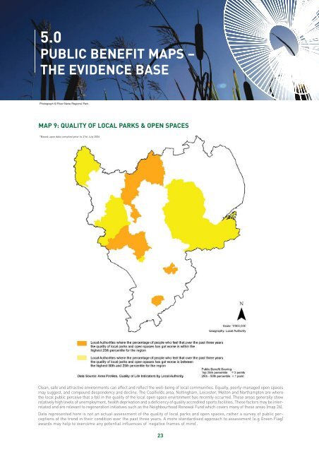
5.0PUBLIC BENEFIT MAPS –THE EVIDENCE BASEPhotograph © River Nene Regional ParkMAP 9: QUALITY OF LOCAL PARKS & OPEN SPACES*Based upon data compiled prior to 21st July 2006Clean, safe and attractive environments can affect and reflect the well-being of local communities. Equally, poorly-managed open spacesmay suggest, and compound despondency and decline. The Coalfields area, Nottingham, Leicester, Melton and <strong>North</strong>ampton are wherethe local public perceive that a fall in the quality of the local open space environment has recently occurred. These areas generally showrelatively high levels of unemployment, health deprivation and a deficiency of quality accredited sports facilities. These factors may be interrelatedand are relevant to regeneration initiatives such as the Neighbourhood Renewal Fund which covers many of these areas (map 26).Data represented here is not an actual assessment of the quality of local parks and open spaces, rather a survey of public perceptionsof the trend in their condition over the past three years. A more standardised approach to assessment (e.g <strong>Green</strong> Flag)awards may help to overcome any potential influences of ‘negative frames of mind’.23