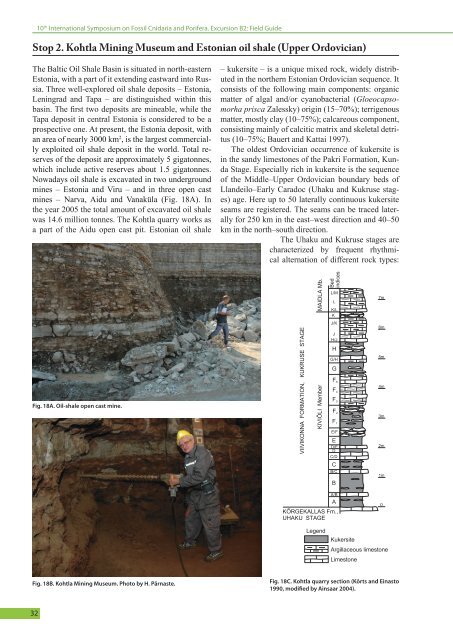
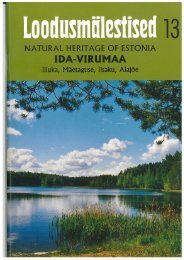
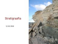
10 th International Symposium on Fossil Cnidaria and Porifera. <strong>Excursion</strong> B2: Field GuideStop 2. Kohtla Mining Museum and Estonian oil shale (Upper Ordovician)The Baltic Oil Shale Basin is situated in north-easternEstonia, with a part of it extending eastward into Russia.Three well-explored oil shale deposits – Estonia,Leningrad and Tapa – are distinguished within thisbasin. The first two deposits are mineable, while theTapa deposit in central Estonia is considered to be aprospective one. At present, the Estonia deposit, withan area of nearly 3000 km 2 , is the largest commerciallyexploited oil shale deposit in the world. Total reservesof the deposit are approximately 5 gigatonnes,which include active reserves about 1.5 gigatonnes.Nowadays oil shale is excavated in two undergroundmines – Estonia and Viru – and in three open castmines – Narva, Aidu and Vanaküla (Fig. 18A). Inthe year 2005 the total amount of excavated oil shalewas 14.6 million tonnes. The Kohtla quarry works asa part of the Aidu open cast pit. Estonian oil shale– kukersite – is a unique mixed rock, widely distributedin the northern Estonian Ordovician sequence. Itconsists of the following main components: organicmatter of algal and/or cyanobacterial (Gloeocapsomorhaprisca Zalessky) origin (15–70%); terrigenousmatter, mostly clay (10–75%); calcareous component,consisting mainly of calcitic matrix and skeletal detritus(10–75%; Bauert and Kattai 1997).The oldest Ordovician occurrence of kukersite isin the sandy limestones of the Pakri Formation, KundaStage. Especially rich in kukersite is the sequenceof the Middle–Upper Ordovician boundary beds ofLlandeilo–Early Caradoc (Uhaku and Kukruse stages)age. Here up to 50 laterally continuous kukersiteseams are registered. The seams can be traced laterallyfor 250 km in the east–west direction and 40–50km in the north–south direction.The Uhaku and Kukruse stages arecharacterized by frequent rhythmicalalternation of different rock types:Fig. 18A. Oil-shale open cast mine.VIIVIKONNA FORMATION, KUKRUSE STAGEKIVIÕLI Member MAIDLA Mb.BedindicesL/MLK/LKJ/KJH/JHG/HGF 5F 4F 3F 2F 1E/FED/EDC/D7m6m5m4m3m2mCB/CB1mA/BAKÕRGEKALLAS Fm.,UHAKU STAGE0LegendKukersiteArgillaceous limestoneLimestoneFig. 18B. Kohtla Mining Museum. Photo by H. Pärnaste.Fig. 18C. Kohtla quarry section (Kõrts and Einasto1990, modified by Ainsaar 2004).32
10 th International Symposium on Fossil Cnidaria and Porifera. <strong>Excursion</strong> B2: Field Guidelimestone with different contents of the argillaceouscomponent and kerogene, kukersite and marl. Therocks are often dolomitized within tectonic disturbancesand karstification zones. Both bedding structuresand nodular textures of oil shale can be observed.The limestones are mainly medium-bedded (2–10cm), marls – thin- to thick-bedded, of seminodulartexture. Kukersite is thin- to thick-bedded, frequentlyalso of nodular and seminodular (net-like) texture.The deposits have been bioturbated before lithification.Frequent burrows and discontinuity surfaces areregistered in the sequence. The sequence is extremelyrich in fossils: over 300 species have been identifiedin the Kukruse Stage, which is the most fossiliferousOrdovician stage of Estonia (Rõõmusoks 1970).The commercially exploited beds (seams) of theKukersite oil-shale occur in the Kiviõli Memberwhich forms the lower part of the Kukruse Stage innortheasten Estonia and is exposed in the territory ofKohtla mining park-museum (Fig. 18B). The KiviõliMember is the richest in kukersite, especially its lowerpart. Here seven thick kukersite layers (A, A’, B, C,D, E and F 1) form the commercial seam of the EstonianOil Shale Deposit (Fig. 18C). The kukersite bedsin the upper part of the Kiviõli member (F 2, F 3, F 4,F 5, G, H, J and K) have no commercial value, thoughsome of them (G and H) are considerably thick (20–40 cm). Kukersite of the lower part of the succession(Fig. 18C, beds “B”, “C”) is rich in cryptostome(Graptodictya, Pachydictya, Phaenopora) and someramose bryozoans (Homotrypa, Nematotrypa) as wellas pelmatozoan debris (Ristnacrius, Baltocrinus). Especiallythe latter accumulations refer to the fluctuatingenergy levels that existed during the Kukruse Age.Kukersineous limestone beds contain mostly trepostomebryozoans, microgastropods, small trilobites,and brachiopods. The middle part of the section (beds“D”, “E”, “F”) is dominated by brachiopods (Sowerbyella,Bekkerina). Here Bilobia musca and Paucicruranavis appear. Another good stratigraphical markerlevel follows, where ostracodes Sigmoopsis rostrata,Polyceratella bicornis and Airina amabilis make theirfirst appearance in beds “F 2/F 3” - “F 3”. Starting withthe beds “F 4” - “G 1” Kullervo panderi can be distinguished.Kukersite beds “F 4”, “G 2” and “H 2” show aremarkable content of echinoderm debris (eocrinoids,stylophorans, homoiostelean and asteroid species).The commonest species of the Kiviõli Member(Rõõmusoks 1970): bryozoans - Chasmatopora furcata,Pseudohornera bifida, Diplotrypa petropolitanapetropolitana, Mesotrypa excentrica; brachiapods:Bicuspina dorsata, Bilobia musca, Cyrtonotellakuckersiana kuckersiana and trilobites: Asaphus (N.)nieszkowskii, Cybellela rex, Chasmops aff. odini.Stop 3. Aluvere quarry (Upper Ordovician)In the abandoned Aluvere quarry near Rakvere,south of the Tallinn–Narva road, thelimestone succession of the Kahula Formation,Haljala Stage (Caradoc) is exposed(Fig. 19). In the southern wall of the quarrya 6 m thick section of the Aluvere andPagari members of the Kahula Formationcan be studied (Fig. 20). The limestone canbe classified as argillaceous wackestone topackstone. The siliciclastic content variesfrom 10 to 25 %, forming 10–20 cm thickcycles, clearly observable in the weatheredwalls of the quarry. In the northern part ofthe quarry, in an old railway cut, the Vasavereand Aluvere members of the KahulaFormation are exposed. Two thin (2–4 cm)Fig. 19. Aluvere quarry.K-bentonite beds outcropping in the middlepart of this wall belong to the Grefsen K-bentonite climate open marine conditions on the open shelf. Thecomplex (Bergström et al. 1995). The rhythmically abundance and high diversity of benthic shelly faunabedded argillaceous wackestones–packstones of the refers to the depositional environment at a moderateHaljala Stage have been deposited in the temperate depth, probably within the photic zone. The Aluvere33