

Parks Victoria Standard Operating Procedure
Parks Victoria Standard Operating Procedure
Parks Victoria Standard Operating Procedure
- No tags were found...

You also want an ePaper? Increase the reach of your titles
YUMPU automatically turns print PDFs into web optimized ePapers that Google loves.
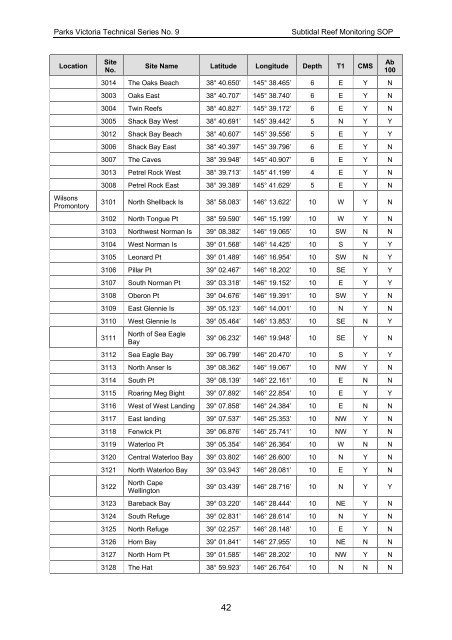
<strong>Parks</strong> <strong>Victoria</strong> Technical Series No. 9Subtidal Reef Monitoring SOPLocationWilsonsPromontorySiteNo.Site Name Latitude Longitude Depth T1 CMS3014 The Oaks Beach 38° 40.650’ 145° 38.465’ 6 E Y N3003 Oaks East 38° 40.707’ 145° 38.740’ 6 E Y N3004 Twin Reefs 38° 40.827’ 145° 39.172’ 6 E Y N3005 Shack Bay West 38° 40.691’ 145° 39.442’ 5 N Y Y3012 Shack Bay Beach 38° 40.607’ 145° 39.556’ 5 E Y Y3006 Shack Bay East 38° 40.397’ 145° 39.796’ 6 E Y N3007 The Caves 38° 39.948’ 145° 40.907’ 6 E Y N3013 Petrel Rock West 38° 39.713’ 145° 41.199’ 4 E Y N3008 Petrel Rock East 38° 39.389’ 145° 41.629’ 5 E Y N3101 North Shellback Is 38° 58.083’ 146° 13.622’ 10 W Y N3102 North Tongue Pt 38° 59.590’ 146° 15.199’ 10 W Y N3103 Northwest Norman Is 39° 08.382’ 146° 19.065’ 10 SW N N3104 West Norman Is 39° 01.568’ 146° 14.425’ 10 S Y Y3105 Leonard Pt 39° 01.489’ 146° 16.954’ 10 SW N Y3106 Pillar Pt 39° 02.467’ 146° 18.202’ 10 SE Y Y3107 South Norman Pt 39° 03.318’ 146° 19.152’ 10 E Y Y3108 Oberon Pt 39° 04.676’ 146° 19.391’ 10 SW Y N3109 East Glennie Is 39° 05.123’ 146° 14.001’ 10 N Y N3110 West Glennie Is 39° 05.464’ 146° 13.853’ 10 SE N Y3111North of Sea EagleBayAb10039° 06.232’ 146° 19.948’ 10 SE Y N3112 Sea Eagle Bay 39° 06.799’ 146° 20.470’ 10 S Y Y3113 North Anser Is 39° 08.362’ 146° 19.067’ 10 NW Y N3114 South Pt 39° 08.139’ 146° 22.161’ 10 E N N3115 Roaring Meg Bight 39° 07.892’ 146° 22.854’ 10 E Y Y3116 West of West Landing 39° 07.858’ 146° 24.384’ 10 E N N3117 East landing 39° 07.537’ 146° 25.353’ 10 NW Y N3118 Fenwick Pt 39° 06.876’ 146° 25.741’ 10 NW Y N3119 Waterloo Pt 39° 05.354’ 146° 26.364’ 10 W N N3120 Central Waterloo Bay 39° 03.802’ 146° 26.600’ 10 N Y N3121 North Waterloo Bay 39° 03.943’ 146° 28.081’ 10 E Y N3122North CapeWellington39° 03.439’ 146° 28.716’ 10 N Y Y3123 Bareback Bay 39° 03.220’ 146° 28.444’ 10 NE Y N3124 South Refuge 39° 02.831’ 146° 28.614’ 10 N Y N3125 North Refuge 39° 02.257’ 146° 28.148’ 10 E Y N3126 Horn Bay 39° 01.841’ 146° 27.955’ 10 NE N N3127 North Horn Pt 39° 01.585’ 146° 28.202’ 10 NW Y N3128 The Hat 38° 59.923’ 146° 26.764’ 10 N N N42


