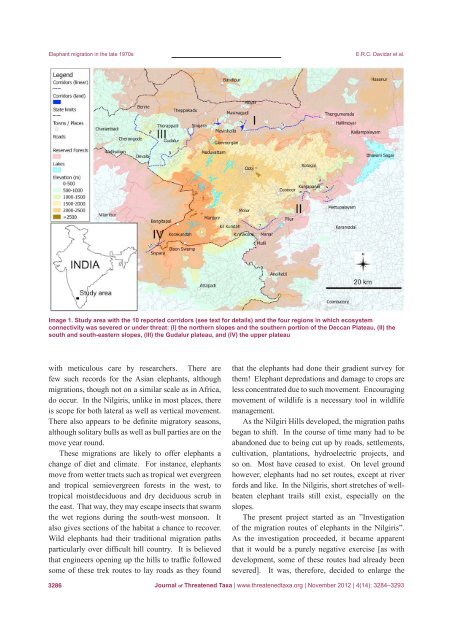
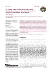
Elephant migration in the late 1970sE.R.C. Davidar et al.Image 1. Study area with the 10 reported corridors (see text for details) and the four regions in which ecosystemconnectivity was severed or under threat: (I) the northern slopes and the southern portion <strong>of</strong> the Deccan Plateau, (II) thesouth and south-eastern slopes, (III) the Gudalur plateau, and (IV) the upper plateauwith meticulous care by researchers. There arefew such records for the Asian elephants, althoughmigrations, though not on a similar scale as in Africa,do occur. In the Nilgiris, unlike in most places, thereis scope for both lateral as well as vertical movement.There also appears to be definite migratory seasons,although solitary bulls as well as bull parties are on themove year round.These migrations are likely to <strong>of</strong>fer elephants achange <strong>of</strong> diet and climate. For instance, elephantsmove from wetter tracts such as tropical wet evergreenand tropical semievergreen forests in the west, totropical moistdeciduous and dry deciduous scrub inthe east. That way, they may escape insects that swarmthe wet regions during the south-west monsoon. Italso gives sections <strong>of</strong> the habitat a chance to recover.Wild elephants had their traditional migration pathsparticularly over difficult hill country. It is believedthat engineers opening up the hills to traffic followedsome <strong>of</strong> these trek routes to lay roads as they foundthat the elephants had done their gradient survey forthem! Elephant depredations and damage to crops areless concentrated due to such movement. Encouragingmovement <strong>of</strong> wildlife is a necessary tool in wildlifemanagement.As the Nilgiri Hills developed, the migration pathsbegan to shift. In the course <strong>of</strong> time many had to beabandoned due to being cut up by roads, settlements,cultivation, plantations, hydroelectric projects, andso on. Most have ceased to exist. On level groundhowever, elephants had no set routes, except at riverfords and like. In the Nilgiris, short stretches <strong>of</strong> wellbeatenelephant trails still exist, especially on theslopes.The present project started as an ”Investigation<strong>of</strong> the migration routes <strong>of</strong> elephants in the Nilgiris”.As the investigation proceeded, it became apparentthat it would be a purely negative exercise [as withdevelopment, some <strong>of</strong> these routes had already beensevered]. It was, therefore, decided to enlarge the3286<strong>Journal</strong> <strong>of</strong> <strong>Threatened</strong> <strong>Taxa</strong> | www.threatenedtaxa.org | November 2012 | 4(14): 3284–3293
Elephant migration in the late 1970sscope <strong>of</strong> the project. In addition, we investigatedthe impediments to elephant movement in the area tosuggest positive steps to encourage movement throughthe provision <strong>of</strong> corridors.The corridor concept applied to wildlife is theprovision <strong>of</strong> a free and, as far as possible, unimpededway for the passage <strong>of</strong> wild animals between twowildlife zones. A corridor’s more important functionis to prevent wild animals from getting isolated insmall pocket-like islands. The process <strong>of</strong> habitatfragmentation has been going on ever since manstarted agriculture. But this problem has, <strong>of</strong> late,become much more acute due to mounting pressureon land.What should be the optimum size <strong>of</strong> a corridor?The length will naturally depend on the distance tobe connected. In doing so, it may become necessaryto take a circuitous route connecting existing jungles.There cannot be any hard and fast rule on the width.It may be anything from approximately 100m toapproximately 2km. The wider the better. Butlimitations such as the lay <strong>of</strong> the land, the types <strong>of</strong>country, and practical consideration such as causingleast disturbance to people who are likely to beaffected by the provisions <strong>of</strong> corridors has to be takeninto account in determining the width.MethodsWildlife literature relating to the Nilgiris wasexhaustively researched for information [in 1978] onelephants’ migration and to identify migration paths.Unfortunately references on the subject were sketchy[at the time <strong>of</strong> this report]. All known elephant habitatswere extensively covered on foot following migrationpaths whenever possible.Four areas seemed <strong>of</strong> particular importance, so wedivided the Nilgiris into four broad sections: (I) thenorthern slopes and the southern portion <strong>of</strong> the DeccanPlateau (called “Deccan Plateau” hereafter), (II) thesouth and southeastern slopes, (III) the Gudalur plateau,and (IV) the upper plateau. [All corridors noted 1 to 10in the four different areas were represented in Image1. In the original report, corridors were marked onphotocopied survey <strong>of</strong> India topographic maps. Thesedocuments would have been adequate forty years agowhen forest <strong>of</strong>ficers knew the area well. These originalE.R.C. Davidar et al.maps were used to produce more readable documents.Reserved forest layers have been redrawn on the basis<strong>of</strong> Prabhakar & Pascal (1996) with GRASS-GIS (2011)and QGIS (2011). The reserved forests approximatelyrepresent the elephant habitat. Most <strong>of</strong> the reservedforests could be represented fairly accurately exceptthe northern Attappadi Reserved Forest, which wasimproperly delimited.]ResultsI. Nilgiri north slopes and Deccan PlateauThis region is defined as the section <strong>of</strong> the DeccanPlateau north <strong>of</strong>, and below the main Nilgiri Plateautowards the east <strong>of</strong> the Mudumalai Wildlife Sanctuary(Image 2). Reserved forests <strong>of</strong> the Sigur range occupymost <strong>of</strong> the land area. Interspersed among these reservedforests are the populous village <strong>of</strong> Masinagudi, somehamlets, tribal settlements, Electricity Board camps,and cattle pens besides cultivated ‘patta’ lands. Thereare also some revenue forests and revenue landsbelonging to the State Government and private forests.Some <strong>of</strong> these non-reserved forests serve as linksbetween reserved forests.This region, the slopes <strong>of</strong> the main Nilgiri range aswell as the slopes leading down to the Moyar River inthe north, supports a fair elephant population. The mostimportant function <strong>of</strong> this area is that it serves as themigration route between Mudumalai and the Wyanadforests on the west, and the Talamalai/Hasanur Plateauand Biligirirangan ranges on the east and northeast.Obstructions to free movement <strong>of</strong> elephants occurin the shape <strong>of</strong> penstocks (huge cylindrical pipes) andtrolley lines leading to the Singara and Moyar powerhouses and the flume channel connecting the two, and‘patta’ lands. In spite <strong>of</strong> these obstructions elephantstrek from one section to the other using interspersedprivate forests and revenue forests. It is essential thatthese non-reserved forests should be preserved t<strong>of</strong>acilitate elephants and other animals to trek from onesection to the other avoiding long detours.1. The Mudumalai-Singara-Sigur connectionGlenmorgan, on the edge <strong>of</strong> the upper Nilgiri slope,is where the head works <strong>of</strong> the Singara power house islocated. Along the entire width <strong>of</strong> this 1,000m slope, atthe foot <strong>of</strong> which the Singara power house is installed,<strong>Journal</strong> <strong>of</strong> <strong>Threatened</strong> <strong>Taxa</strong> | www.threatenedtaxa.org | November 2012 | 4(14): 3284–32933287