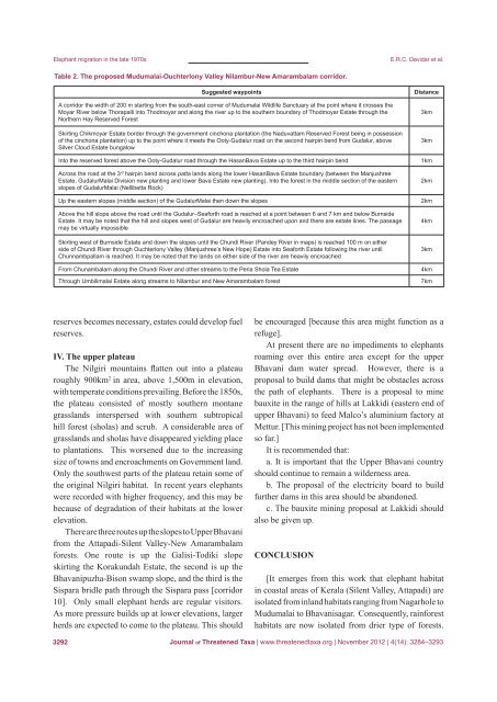
Elephant migration in the late 1970sE.R.C. Davidar et al.Table 2. The proposed Mudumalai-Ouchterlony Valley Nilambur-New Amarambalam corridor.Suggested waypointsA corridor the width <strong>of</strong> 200 m starting from the south-east corner <strong>of</strong> Mudumalai Wildlife Sanctuary at the point where it crosses theMoyar River below Thorapalli into Thodmoyar and along the river up to the southern boundary <strong>of</strong> Thodmoyar Estate through theNorthern Hay Reserved ForestSkirting Chikmoyar Estate border through the government cinchona plantation (the Naduvattam Reserved Forest being in possession<strong>of</strong> the cinchona plantation) up to the point where it meets the Ooty-Gudalur road on the second hairpin bend from Gudalur, aboveSilver Cloud Estate bungalowInto the reserved forest above the Ooty-Gudalur road through the HasanBava Estate up to the third hairpin bendAcross the road at the 3 rd hairpin bend across patta lands along the lower HasanBava Estate boundary (between the ManjushreeEstate, GudalurMalai Division new planting and lower Bava Estate new planting). Into the forest in the middle section <strong>of</strong> the easternslopes <strong>of</strong> GudalurMalai (Nellibetta Rock)Up the eastern slopes (middle section) <strong>of</strong> the GudalurMalai then down the slopesAbove the hill slope above the road until the Gudalur–Seaforth road is reached at a point between 6 and 7 km and below BurnsideEstate. It may be noted that the hill and slopes west <strong>of</strong> Gudalur are heavily encroached upon and there are estate lines. The passagemay be virtually impossibleSkirting west <strong>of</strong> Burnside Estate and down the slopes until the Chundi River (Pandey River in maps) is reached 100 m on eitherside <strong>of</strong> Chundi River through Ouchterlony Valley (Manjushree’s New Hope) Estate into Seaforth Estate following the river untilChunnambpallam is reached. It may be noted that the lands on either side <strong>of</strong> the river are heavily encroachedFrom Chunambalam along the Chundi River and other streams to the Peria Shola Tea EstateThrough Umbilimalai Estate along streams to Nilambur and New Amarambalam forestDistance3km3km1km2km2km4km3km4km7kmreserves becomes necessary, estates could develop fuelreserves.IV. The upper plateauThe Nilgiri mountains flatten out into a plateauroughly 900km 2 in area, above 1,500m in elevation,with temperate conditions prevailing. Before the 1850s,the plateau consisted <strong>of</strong> mostly southern montanegrasslands interspersed with southern subtropicalhill forest (sholas) and scrub. A considerable area <strong>of</strong>grasslands and sholas have disappeared yielding placeto plantations. This worsened due to the increasingsize <strong>of</strong> towns and encroachments on Government land.Only the southwest parts <strong>of</strong> the plateau retain some <strong>of</strong>the original Nilgiri habitat. In recent years elephantswere recorded with higher frequency, and this may bebecause <strong>of</strong> degradation <strong>of</strong> their habitats at the lowerelevation.There are three routes up the slopes to Upper Bhavanifrom the Attapadi-Silent Valley-New Amarambalamforests. One route is up the Galisi-Todiki slopeskirting the Korakundah Estate, the second is up theBhavanipuzha-Bison swamp slope, and the third is theSispara bridle path through the Sispara pass [corridor10]. Only small elephant herds are regular visitors.As more pressure builds up at lower elevations, largerherds are expected to come to the plateau. This shouldbe encouraged [because this area might function as arefuge].At present there are no impediments to elephantsroaming over this entire area except for the upperBhavani dam water spread. However, there is aproposal to build dams that might be obstacles acrossthe path <strong>of</strong> elephants. There is a proposal to minebauxite in the range <strong>of</strong> hills at Lakkidi (eastern end <strong>of</strong>upper Bhavani) to feed Malco’s aluminium factory atMettur. [This mining project has not been implementedso far.]It is recommended that:a. It is important that the Upper Bhavani countryshould continue to remain a wilderness area.b. The proposal <strong>of</strong> the electricity board to buildfurther dams in this area should be abandoned.c. The bauxite mining proposal at Lakkidi shouldalso be given up.Conclusion[It emerges from this work that elephant habitatin coastal areas <strong>of</strong> Kerala (Silent Valley, Attapadi) areisolated from inland habitats ranging from Nagarhole toMudumalai to Bhavanisagar. Consequently, rainforesthabitats are now isolated from drier type <strong>of</strong> forests.3292<strong>Journal</strong> <strong>of</strong> <strong>Threatened</strong> <strong>Taxa</strong> | www.threatenedtaxa.org | November 2012 | 4(14): 3284–3293
Elephant migration in the late 1970sAnd elephants can no more circle the Nilgiris, as they probably used todo, to find better feeding grounds. However, this state <strong>of</strong> affairs shouldnot prevent the search for solutions. Forging new corridors, reshapingboundaries between village lands and reserved forests in order to preventconflicts with elephants, remains a priority.]The considerations that weighed uppermost when makingrecommendations was that they should be pragmatic and capable <strong>of</strong>implementation. Care was taken not to propose any grandiose schemes.The recommendations are modest and should be workable. For thesuccess <strong>of</strong> projects <strong>of</strong> this nature it is essential that local sympathies arenot alienated. The cooperation and support <strong>of</strong> local people should besought and obtained.Lines <strong>of</strong> action and priorities have been indicated. Naturally therecommendations vary to suit the local conditions. While some requirepositive action, in the case <strong>of</strong> others all that is required is a safeguard thatthe prevailing conditions are not disturbed. Of course, the most importantrequirement is enthusiasm on the part <strong>of</strong> the concerned authorities, andthe political will to put the recommendations into effect.ReferencesChampion, H. & S. Seth (1968). A Revised Survey <strong>of</strong> The Forest Types <strong>of</strong> India.Government <strong>of</strong> India Press, xxvii+404pp.Davidar, E.R.C. (1978). Distribution and status <strong>of</strong> the Nilgiri Tahr Hemitragushylocrius, 1975–1978. <strong>Journal</strong> <strong>of</strong> the Bombay Natural History Society 75: 815–844.Fletcher, F.W.F. (1911). Sport on the Nilgiris and in Wyanad. MacMillan, London,xvii+455pp.GRASS Development Team (2010). Geographic Resources Analysis Support System(GRASS) S<strong>of</strong>tware, Version 6.4.0. Open Source Geospatial Foundation. http://grass.osgeo.org.Johnsingh, A.J.T. & A.C. Williams (1999). Elephant corridors in India: lessons forother Elephant range countries. Oryx 33(3): 210–214.Menon, V., V. Tiwari, S. Easa & R. Sukumar (2005). Right <strong>of</strong> Passage: ElephantCorridors <strong>of</strong> India. Wildlife Trust <strong>of</strong> India, 287pp.Prabhakar, R. & J.-P. Pascal (1996). Nilgiri Biosphere Reserve Area. Vegetationand land use.Map 1:100,000. Centre for Ecological Sciences, Indian Institute <strong>of</strong>Science and the French Institute <strong>of</strong> Pondicherry, Pondicherry.Quantum GIS Development Team (2011). Quantum GIS Geographic InformationSystem. Open Source Geospatial Foundation Project. http://qgis.osgeo.org.Santiapillai, C. & P. Jackson (1990). The Asian Elephant: An Action Plan for ItsConservation. IUCN, 80pp.Tamil Nadu Forest Department (2009). Report <strong>of</strong> the Expert Committee Formedin Pursuance <strong>of</strong> the Direction <strong>of</strong> the Hon’ble High Court in W.P.N.10098/2008,2762 & 2839 <strong>of</strong> 2009. Unpublished. http://www.forests.tn.nic.in/graphics/Expert_Committee_Report.pdf, 98pp.E.R.C. Davidar et al.Acknowledgements1981: We thank Mr. A.M. Mahmood HussainIFS, Additional Chief Conservator <strong>of</strong> Forests,Tamil Nadu Forest Department, and Y.S.Kadakshamani IFS, DFO Coimbatore for theirformal permission to work in Mudumalai andCoimbatore Reserved Forests. But for theenthusiasm <strong>of</strong> Mr. J.C. Daniel, Chairman, AsianElephant Specialist Group, this study wouldnot have been possible. We also thank him formeeting the expenditure incurred on the study.We owe a debt <strong>of</strong> gratitude to the plantingcommunity who helped and shared information.We thank Mr. B. Palaniappan, Group Manager,Woodbriar Estate Ltd., Mr. C. RamachandraRao, Group Manager, Manjushree Plantations,Ltd., Mr. V.A. Krishnan, Senior Manager,Kilkotagiri Estates, Mr. K. Madappa, Manager,Korakundah Estate, Mr. E. Luke, Manager,Periashola Estate, Mr. D.R.B. Tyman, ManagingDirector, Tea Estates India Ltd., and Mr. A.Arunachalam IFS, Managing Director, TANTEA.Mr. Jude Michael, Shikari Bokkan, and informantMari <strong>of</strong> Sirur helped on the many treks. To thosewho are going to initiate action on this report andimplement the recommendations we wish themsuccess.2011: We thank Dr. Ajay Desai (Co-Chair, AsianElephant Specialist Group), Dr. Simon Hedges(Co-Chair, Asian Elephant Specialist Group),and Dr. Simon Stuart, Chair, IUCN SpeciesSurvival Commission, for their initial interest inthis publication. Dr. Asad Rahmani (Director,BNHS) and Dr. Ajay Desai kindly granted uspermission to utilise the draft and publish it.We thank the <strong>Journal</strong> <strong>of</strong> <strong>Threatened</strong> <strong>Taxa</strong> andin particular the Founder & Chief Editor, Dr.Sanjay Molur, for their enlightened editorialpolicy, and an anonymous referee <strong>of</strong> the <strong>Journal</strong><strong>of</strong> <strong>Threatened</strong> <strong>Taxa</strong> for constructive comments.Dr. S. Jayakumar, Department <strong>of</strong> Ecology andEnvironmental Sciences, Pondicherry University,kindly provided us the elevation map <strong>of</strong> theregion.Author Details: The late E.R.C. Da v id a r was alawyer by pr<strong>of</strong>ession and a conservationist. Hepioneered studies on the Nilgiri tahr, elephantcorridors, the dhole and the striped hyena. Heestablished what may be the first ever privatereserve in India and has authored a book on therecent ecological history <strong>of</strong> the Nilgiris.Pe t e r Da v id a r holds a MPhil in Wildlife Biology.He has undertaken surveys on elephant corridorsand is presently a trustee <strong>of</strong> the Sigur NatureTrust, a private wildlife corridor. He is interestedin wildlife photography.Pr i y a Da v id a r is a pr<strong>of</strong>essor <strong>of</strong> ecology at thePondicherry University. She teaches conservationbiology and behavior. Her research interestsspan over the fields <strong>of</strong> biogeography, biodiversity,pollination ecology and conservation.Je a n-Ph i l ip p e Pu y r a v a u d is an ecologist associatedwith ECOS, a trust for the conservation <strong>of</strong>nature. His main interest is habitat managementfor endangered species. He advises MSc andPhD students <strong>of</strong> the Pondicherry University inresearch methodology and landscape ecology.Author Contribution: ERCD was the principalinvestigator <strong>of</strong> this project. He designed thestudy, conducted the field surveys and wrote alonger unpublished version <strong>of</strong> this paper for theAsian Elephant Specialist Group <strong>of</strong> the IUCN.PeD assisted in the field survey. PrD assistedwith editorial work <strong>of</strong> the first version and helpedrevise the abridged version <strong>of</strong> the paper. J-PPrevised and edited this abridged version <strong>of</strong> thepaper, and prepared the maps.<strong>Journal</strong> <strong>of</strong> <strong>Threatened</strong> <strong>Taxa</strong> | www.threatenedtaxa.org | November 2012 | 4(14): 3284–32933293