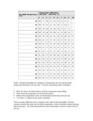
Modeling the West African Monsoon - cmmap
Modeling the West African Monsoon - cmmap
Modeling the West African Monsoon - cmmap

You also want an ePaper? Increase the reach of your titles
YUMPU automatically turns print PDFs into web optimized ePapers that Google loves.
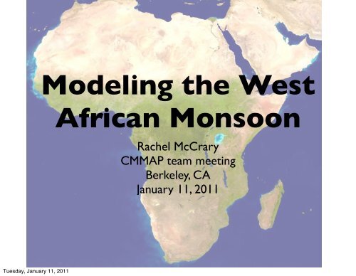
<strong>Modeling</strong> <strong>the</strong> <strong>West</strong><strong>African</strong> <strong>Monsoon</strong>Rachel McCraryCMMAP team meetingBerkeley, CAJanuary 11, 2011Tuesday, January 11, 2011
Seasonal Progression of RainOver <strong>West</strong> AfricaTuesday, January 11, 2011
Seasonal Progression of RainOver <strong>West</strong> AfricaTuesday, January 11, 2011
Seasonal Progression of RainOver <strong>West</strong> AfricaTuesday, January 11, 2011
Seasonal Progression of RainOver <strong>West</strong> AfricaTuesday, January 11, 2011
Seasonal Progression of RainOver <strong>West</strong> AfricaTuesday, January 11, 2011
Seasonal Progression of RainOver <strong>West</strong> AfricaTuesday, January 11, 2011
Seasonal Progression of RainOver <strong>West</strong> AfricaTuesday, January 11, 2011
Seasonal Progression of RainOver <strong>West</strong> AfricaTuesday, January 11, 2011
Seasonal Progression of RainOver <strong>West</strong> AfricaTuesday, January 11, 2011
Seasonal Progression of RainOver <strong>West</strong> AfricaTuesday, January 11, 2011
Seasonal Progression of RainOver <strong>West</strong> AfricaTuesday, January 11, 2011
Seasonal Progression of RainOver <strong>West</strong> AfricaTuesday, January 11, 2011
Why Study <strong>the</strong> <strong>Monsoon</strong>?• Understand and predict <strong>the</strong>seasonal rains over <strong>West</strong> Africa.• 300 million inhabitants (2006)• Rainfed crop production is <strong>the</strong>main source of food and incomein <strong>the</strong> Sahel.• Irrigation, mechanization andfertilizers largely unavailable tofarmers• Currently experiencing a fooddeficit crisis due to rapidly goingpopulation and low foodproduction over <strong>the</strong> pastdecadesDensité de population(hab/km² - 2005)Plus de 500200 à 50080 à 20040 à 8010 à 400Moins de 10MAURITANIENouakchottMALINIGERDakarSENEGALTCHADGAMBIENiameyBamakoBURKINAOuagadougouMaiduguriN'DjaménaFASOGUINEE-GUINEEKanoBISSAUKadunaConakryBENINJosGHANANIGERIAFreetownCOTETOGOAbujaSIERRAIbadanLEONED'IVOIREKumasiMonroviaLoméBeninCotonouLagosCityLIBERIACAMEROUNAccraAbidjanPortDoualaHarcourtYaoundéCAP-VERT© Club du Sahel et de l'Afrique de l'Ouest / OCDE 2006Densité de population en Afrique de l'Ouest (2005)Tuesday, January 11, 2011
Why Study <strong>the</strong> <strong>Monsoon</strong>?• Understand and predict <strong>the</strong>seasonal rains over <strong>West</strong> Africa.• 300 million inhabitants (2006)• Rainfed crop production is <strong>the</strong>main source of food and incomein <strong>the</strong> Sahel.• Irrigation, mechanization andfertilizers largely unavailable tofarmers• Currently experiencing a fooddeficit crisis due to rapidly goingpopulation and low foodproduction over <strong>the</strong> pastdecadesTuesday, January 11, 2011
Why Study <strong>the</strong> <strong>Monsoon</strong>?• Multiscale interactionsassociated with <strong>the</strong> monsoon- atmosphere, ocean, landsurface- large-scale circulation toindividual rain events.- AJE, AEW, MCSs, monsoonflow etc.• Great test bed for <strong>the</strong> Multiscale <strong>Modeling</strong> Framework (MMF).Tuesday, January 11, 2011
Why Study <strong>the</strong> <strong>Monsoon</strong>?• Multiscale interactionsassociated with <strong>the</strong> monsoon- atmosphere, ocean, landsurface- large-scale circulation toindividual rain events.- AJE, AEW, MCSs, monsoonflow etc.• Great test bed for <strong>the</strong> Multiscale <strong>Modeling</strong> Framework (MMF).Tuesday, January 11, 2011
Model Runs• Two AMIP style runs forcedwith observed SSTs from <strong>the</strong>HadISST dataset for <strong>the</strong>period 1997-2006.• 1.9ºlat x 2.5ºlon, 30 levels• Control run - Standard CAMversion 3.5.• SP-CAM version 3.5• CRM oriented in N-Sdirection.Monthly and daily fields1997 200620042006hourly fieldsand CRM output• Will be available to CMMAPmembers via <strong>the</strong> SDSC(soon?)Tuesday, January 11, 2011
Tuesday, January 11, 2011Observed Precipitation (GPCP)
GPCP• Latitudinal position of ITCZand rain fall reaches nor<strong>the</strong>rnmost extent during borealsummer• Three precipitation maxima -1) on <strong>the</strong> west coast, 2) over<strong>the</strong> eastern portion of <strong>the</strong>Guinean coast, and 3) over<strong>the</strong> Ethiopian highlandsTuesday, January 11, 2011
GPCP• Latitudinal position of ITCZand rain fall reaches nor<strong>the</strong>rnmost extent during borealsummer• Three precipitation maxima -1) on <strong>the</strong> west coast, 2) over<strong>the</strong> eastern portion of <strong>the</strong>Guinean coast, and 3) over<strong>the</strong> Ethiopian highlandsTuesday, January 11, 2011
GPCP• Low level (925 hPa) windsfrom ERA-interim.• Seasonal reversal of <strong>the</strong>winds.• Winds are offshore duringDJF and onshore during JJA.• <strong>Monsoon</strong> winds bring moistair from <strong>the</strong> Gulf of Guineaonto land and help supplymoisture for convectionTuesday, January 11, 2011
GPCPTuesday, January 11, 2011
GPCPControlControl - GPCPTuesday, January 11, 2011
Tuesday, January 11, 2011GPCP SP-CAM SP-CAM - GPCP
ERA - Interim<strong>African</strong> Easterly Jet• 600 hPa average JJA zonal wind.• Direct result of <strong>the</strong> temperature andmoisture gradients that occur overwest Africa during <strong>the</strong> boreal summer.• Exhibits baratropic-baroclinic instabilityControlSP-CAMTuesday, January 11, 2011
<strong>African</strong> Easterly JetCross section at 0ºW100hPa1000hPa12S40NTuesday, January 11, 2011
ERA - Interim<strong>African</strong> Easterly JetCross section at 0ºW• Intensity of AEJ is underestimated byboth models.• Surface westerlies larger in bothmodels.ControlSP-CAMTuesday, January 11, 2011
Tuesday, January 11, 2011Saharan Heat Low
ERA - Interim Control Control-ERAControl• Heat low generallywell represented.• Too deep in wintertoo weak in sumer.• Extends to far to<strong>the</strong> west in mostseasons.Tuesday, January 11, 2011
ERA - Interim Control Control-ERASP-CAM• Much like <strong>the</strong>standard CAM...• Heat low generallywell represented.• Too deep in wintertoo weak in sumer.• Extends to far to<strong>the</strong> west in mostseasons.Tuesday, January 11, 2011
<strong>African</strong> EasterlyWaves• Average Eddy KineticEnergy (EKE) forMJJAS.• Have applied a highpassfilter to u’ and v’.• CAM underestimatesAEW activity• SPCAM seems tooverestimate.Tuesday, January 11, 2011
Future Work• Understand why three precipitation maxima occur in overwest Africa. Why doesn’t <strong>the</strong> standard CAM represent <strong>the</strong>maxima over <strong>the</strong> Guinean coast but SP-CAM does?• Detailed analysis of structure of AEW in observations and <strong>the</strong>two models.• Examine <strong>the</strong> dirunal cycle of convection over west Africausing <strong>the</strong> AMMA observations for comparison.• Examine <strong>the</strong> importance of land surface conditions for <strong>the</strong>dynamics of <strong>the</strong> monsoon.Tuesday, January 11, 2011
Tuesday, January 11, 2011<strong>African</strong> EasterlyWaves & <strong>the</strong> <strong>African</strong>Easterly Jet