EGNOS SDK Development process - EGNOS Portal
EGNOS SDK Development process - EGNOS Portal
EGNOS SDK Development process - EGNOS Portal

Create successful ePaper yourself
Turn your PDF publications into a flip-book with our unique Google optimized e-Paper software.
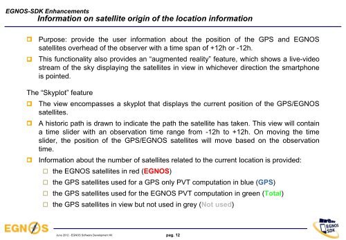
<strong>EGNOS</strong>-<strong>SDK</strong> EnhancementsInformation on satellite origin of the location informationPurpose: provide the user information about the position of the GPS and <strong>EGNOS</strong>satellites overhead of the observer with a time span of +12h or -12h.This functionality also provides an “augmented reality” feature, which shows a live-videostream of the sky displaying the satellites in view in whichever direction the smartphoneis pointed.The “Skyplot” featureThe view encompasses a skyplot that displays the current position of the GPS/<strong>EGNOS</strong>satellites.A historic path is drawn to indicate the path the satellite has taken. This view will containa time slider with an observation time range from -12h to +12h. On moving the timeslider, the position of the GPS/<strong>EGNOS</strong> satellites will move based on the observationtime.Information about the number of satellites related to the current location is provided: the <strong>EGNOS</strong> satellites in red (<strong>EGNOS</strong>) the GPS satellites used for a GPS only PVT computation in blue (GPS) the GPS satellites used for the <strong>EGNOS</strong> PVT computation in green (Total) the GPS satellites in view but not used in grey (Not used)June 2012 - <strong>EGNOS</strong> Software <strong>Development</strong> Kitpag. 12