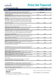
Topocad modules functionality overview - Adtollo
Topocad modules functionality overview - Adtollo
Topocad modules functionality overview - Adtollo

Create successful ePaper yourself
Turn your PDF publications into a flip-book with our unique Google optimized e-Paper software.
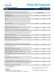
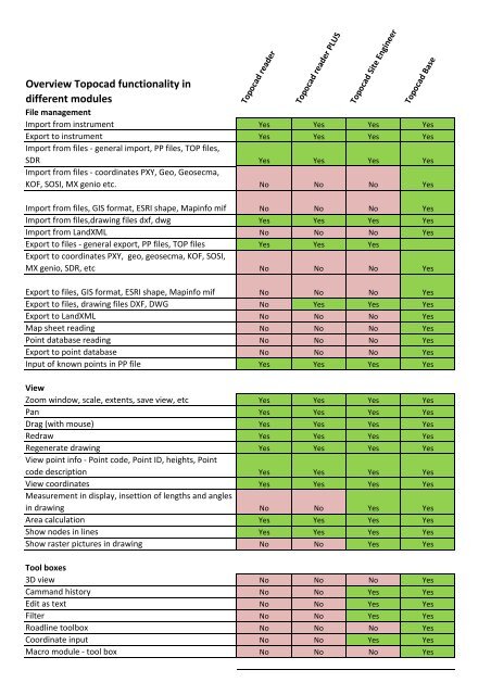
Overview <strong>Topocad</strong> <strong>functionality</strong> indifferent <strong>modules</strong><strong>Topocad</strong> reader<strong>Topocad</strong> reader PLUS<strong>Topocad</strong> Site Engineer<strong>Topocad</strong> BaseDrawingLayer manager Yes Yes Yes YesLayer collections No No Yes YesSymbols ‐ <strong>overview</strong> and editing Yes Yes Yes YesLine types ‐ <strong>overview</strong> and editing Yes Yes Yes YesBase line, UCS Yes Yes Yes YesScale setting in drawing No No Yes YesCoordinate system No No Yes YesExternal references ‐ external references from TOP,DWG, DXF, DGN, PXY, KOF, SOSI, SDR, MX Genio, Shape,Mapinfo and other file formats No No Yes YesSearch object No No Yes YesObject properties Yes Yes Yes YesView history Yes Yes Yes YesSystemEdit code table Yes Yes Yes YesControl codes Yes Yes Yes YesAttribute management Yes Yes Yes YesSymbol management and editing Yes Yes Yes YesLine type management Yes Yes Yes YesRoad line manager No No No YesToolbox for point codes Yes Yes Yes YesSurvey dataCalculation of survey data Yes Yes Yes YesProcess coordinates from field to drawing Yes Yes Yes YesCalculate GPS data Yes Yes Yes YesCalculate GPS coordinates Yes Yes Yes YesCalculate levelling No No Yes YesSave levelling output No No Yes YesManuel entry of survey data Yes Yes Yes YesCreate traverse No No No YesCreate reduced mean values (face measurement) Yes Yes Yes YesCreate slew and lift reportRailroad module (requires profile module)Show history Yes Yes Yes YesPrint out survey data protocol No No Yes YesCoordinatesManual input of coordinates in a coordinate file No No No YesPrint out coordinates No No No YesTraverseManual input of data to traverse No No No YesImport survey data to traverse No No No Yescalculate traverse No No No Yes
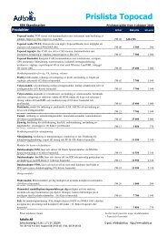
Overview <strong>Topocad</strong> <strong>functionality</strong> indifferent <strong>modules</strong><strong>Topocad</strong> reader<strong>Topocad</strong> reader PLUS<strong>Topocad</strong> Site Engineer<strong>Topocad</strong> BaseRoad linesManual input of road line protocol No No No YesImport road lines from LIN, DRD, Geosecma, LandXML No No No YesExport road lines to ALC, LandXML, LIN No No No YesAdjust road line No No No YesCheck of road line No No No YesInput length tableRailroad module (requires profile module)Adjust sections No No No Yesextract kilometerRailroad module (requires profile module)Input of crossfall (camber) No No No YesTerrain modellingStatistics of terrain models No No No Yes3D view of terrain models No No No YesAdd several terrain models on top of each other in 3D No No No Yesdrape raster pictures (ortophotos) above terrain models No No No YesMove terrain models in height No No No YesEdit terrain models ‐ move single point No No No YesSwap triangles in terrain model No No No YesDelete and create triangles in terrain model No No No YesUse direction arrows in digital terrain model No No No YesExternal references in terrain model No No No YesShov history in terrain models No No No YesProfiles ‐ Longitudinal sectionsManual input of road profilesImport road profile from DRD, LandXML, general import,PRFExport road profile to ALC, LandXML, PRFAdjust profileCheck of profileLength tableExtract kilometerConstruct profile formGraphic input and editing of profileInsert symbols in profile formProfile form ‐ road geometryProfile form ‐ slope and radiusProfile form ‐ profile differencesProfile form ‐ areasProfile form ‐ tangent pointsProfile form ‐ terrain heightsProfile form ‐ terrain profileProfile moduleProfile moduleProfile moduleProfile moduleProfile moduleProfile moduleRailroad module (requires profile module)Railroad module (requires profile module)Profile moduleProfile moduleProfile moduleProfile moduleProfile moduleProfile moduleProfile moduleProfile moduleProfile moduleProfile module
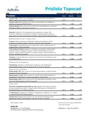
Overview <strong>Topocad</strong> <strong>functionality</strong> indifferent <strong>modules</strong>Section templatesCreate section templatesuse side lines in section templatesUse side profiles in section templatesuse any number of layers in the super structureEdit section templates<strong>Topocad</strong> reader<strong>Topocad</strong> reader PLUS<strong>Topocad</strong> Site EngineerDesign module (requires profile)Design module (requires profile)Design module (requires profile)Design module (requires profile)Design module (requires profile)Design module (requires profile)<strong>Topocad</strong> BaseCross sectioningCalculate sections between two terrain modelsEarthworks/Design (requires profile)Earthworks/Design (requires profile)use of several different terrain models along a road lineCalculate area between two terrain models in crosssectionsCalculate top soil in cross sectioningCalculate volumes for different heights in the lowerterrain modelEditing of cross sectionsRecalculate terrain models in cross sectionsrecalculate profiles in cross sectionsRecalculate road lines in cross sectionsRecalculate cross fall in cross sectionsCreate lines and sections to plane data (drawing) fromcross sectionsEarthworks/Design (requires profile)Earthworks/Design (requires profile)Design module (requires profile)Design module (requires profile)Design module (requires profile)Design module (requires profile)Design module (requires profile)Design module (requires profile)Design module (requires profile)Design module (requires profile)Create digital terrain model direct from cross sectionsCalculate cross sections using tolerances in plane andheight in theoretic road.Design module (requires profile)Design module (requires profile)Replace section templates in cross section calculationsDesign module (requires profile)Interaktiv beräkning av areor och massor i tvärsektionerDesign module (requires profile)
Overview <strong>Topocad</strong> <strong>functionality</strong> indifferent <strong>modules</strong>Net adjustmentImport survey data to net adjustmentManual input of observationsCalculate net adjustment<strong>Topocad</strong> reader<strong>Topocad</strong> reader PLUS<strong>Topocad</strong> Site EngineerNet adjustment moduleNet adjustment moduleNet adjustment moduleNet adjustment module<strong>Topocad</strong> BaseSave points from net adjustment to known point fileSave net adjustment to drawingLock calculated heightsMove measurement seriesMove pointsView history in net adjustmentUndo/redo in net adjustmentGross error testCheck of avoided observationsConnection testReport double measured lengthsReport double measured heightsConnection error between known heightsAutomatic test of connected heightsPost check of calculated heightsPoint numbering checkMaeasurements in plane reportTable of not double measured heightsKnown points reportSimulation of net adjustmentNet adjustment moduleNet adjustment moduleNet adjustment moduleNet adjustment moduleNet adjustment moduleNet adjustment moduleNet adjustment moduleNet adjustment moduleNet adjustment moduleNet adjustment moduleNet adjustment moduleNet adjustment moduleNet adjustment moduleNet adjustment moduleNet adjustment moduleNet adjustment moduleNet adjustment moduleNet adjustment moduleNet adjustment moduleNet adjustment moduleRailroadSlew and lift protocolOverlap measurementTunnelCreate tunnel theoretic sectionCalculate tunnel terrain modelInteractive calculation of areas and volumes in the crosssection protocolInsertion of tunnel sections in the drawingRailroad module (requires profile module)Railroad module (requires profile module)Railroad module (requires profile module)Tunnel module (requires profile module)Tunnel module (requires profile module)Tunnel module (requires profile module)Tunnel module (requires profile module)Tunnel module (requires profile module)