South Gloucestershire industrial places heritage trail
South Gloucestershire industrial places heritage trail
South Gloucestershire industrial places heritage trail

Create successful ePaper yourself
Turn your PDF publications into a flip-book with our unique Google optimized e-Paper software.
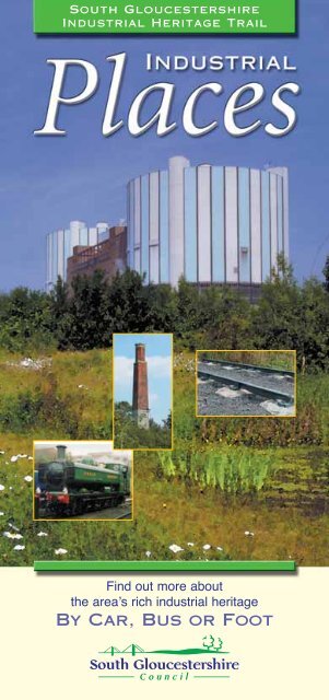
<strong>South</strong> <strong>Gloucestershire</strong>Industrial Heritage TrailFind out more aboutthe area’s rich <strong>industrial</strong> <strong>heritage</strong>By Car, Bus or Foot
Getting the best from this bookletKey to symbolsAAccess limited to view from roador footpath,no access to siteBus service within walkingdistanceAvon Cycleway nearbyDramway Footpath / Bristol &Bath Railway Path and otherfootpaths nearbyCotswold Way and otherfootpaths nearbyMonarch’s Way and otherfootpaths nearbyRiver Avon Trail and otherfootpaths nearbyContentsPGRCommunity Forest Path andother footpaths nearbySevern Way and other footpathsnearbyParking for cars on siteRail station within walkingdistancePublic toilets on siteWheelchair access to buildingCafe or restaurant on siteGrid reference numberPageGetting the best from this booklet 3Introduction 4Top Twenty Plus One 5Along the Trail 6Ride, drive or walk 8Energy and power 9Raw materials 10-13Routes and transport 14-18Trades, work<strong>places</strong> and homes 19-21End products 22-24Sponsorship 25Site index26 & inside back coverMap of the Trailinside back coverFurther informationfold-in back coverPeople have always worked hard in <strong>South</strong> <strong>Gloucestershire</strong>, usingnatural resources and human ingenuity. You’ll find evidence ofpast and present working <strong>places</strong> everywhere!Discover some of them for yourself with the help of this booklet.Routes, themes and propertiesIf you want a real flavour of <strong>South</strong> <strong>Gloucestershire</strong>’s<strong>industrial</strong> <strong>heritage</strong> and good family days out at the sametime, follow the Top Twenty Plus One route. Most of the<strong>places</strong> on it have facilities for visitors and all are easy to find.The route is shown on the fold-out map at the back, linkingthe numbered sites.The other <strong>places</strong> in this booklet are also numbered, indexedand described in the main text. You may want to choose anarea to visit and then come back again and enjoy sites inanother area. To help you follow a particular theme, we’vearranged the booklet under topic headings.If you’re walking, there are lots of opportunities to deviseinteresting routes using off-road paths and tracks as well aslong-distance walking <strong>trail</strong>s. If you’re cycling, you can usebridleways and other public rights of way not designated asfootpaths and, of course, the National Cycle Networkroutes. Many of the sites and properties we’vereferred to are privately ownedand most are not open tovisitors. Please respect theprivacy of people working andliving in these <strong>places</strong> andview them from a discreetdistance, remaining onroads or public footpaths.Where there is access tobuildings, check times ofopening before you visit.Where there are old structures andworkings, always take particularcare.<strong>South</strong> <strong>Gloucestershire</strong> Councilcan take no responsibility forinjury or damage during suchvisits.Industrial Places3
Along the TrailAlong the TrailTake our pick or pick your <strong>places</strong>Many of you will want to follow the <strong>trail</strong> of the Top TwentyPlus One. If you want to make up your own <strong>industrial</strong><strong>heritage</strong> <strong>trail</strong>, you can do it in one of two ways. Pick a zone tovisit, identify the numbered sites within that zone that areshown on the map at the back, and use the site index tolocate the relevant descriptive text under a theme heading.We have shown three zones on the map, working from westto east:Kingswood Leather WorksMaking <strong>industrial</strong> connectionsEven the simplest of working practices usually involves achain of activities. A farmer needs tools and machinery,transport for his livestock or produce, roads to travel on,power for his sheds, water from the mains or a private supply,wire for fences, hinges for gates, clothes for his back and stoutboots ... the boot-maker needs leather, and heavy thread,eyelets and woven laces, his own specialised equipment andfood ... the baker needs flour for bread and power for hisovens, stainless steel working surfaces and packaging for thefinished goods ... the links are complex but fascinating.Throughout <strong>South</strong> <strong>Gloucestershire</strong>, people have beensupplying and buying, trading and transporting, working in aweb of activity that is almost as old as the hills!Make the connections as you visit the sites!Zone One includes the Severnside,Thornbury, Almondsbury, Patchwayand north Bristol areas (west of the M5where it runs north of the M4 and theurban area in northern Bristol, whichhas expanded considerably recently,west of the M4/M32 in north Bristol.Zone Two includes Yate and ChippingSodbury and the mainly rural area withmany smaller communities north of theM4 and east of the M5.Zone Three is south of the M4 andeast of the M32; it includes Kingswood,adjoining areas and both the historicand modern developments east ofBristol, south to the river Avon.Heritage TrailTheme-based toursAlternatively, you can choose a theme to follow bylocating the numbered sites, identified in the appropriatechapter of text, on the map at the back and an OrdnanceSurvey map. You can then decide on the best route forvisiting them.Grid referencesThe Ordnance Survey grid reference number for each site isshown beside its name, listed below the relevant text.Industrial Places67
Ride, Drive or WalkEnergy and PowerChipping SodburyHeritage Trail8Map out your routeBuses will take you to and from many <strong>places</strong> shown inIndustrial Places. The main railway station for the area isBristol Parkway and suburban routes serve Filton AbbeyWood, Patchway, Pilning, Yate and Severn Beachstations.Check times and stopping <strong>places</strong> of public transport whenplanning your route - contact telephone numbers are givenon the back cover.If you want to visit all or many of the sites in one or morezones of the Industrial Places, then you’ll need a car.The fold-out map indicates the routes you could follow butyou will also need OS Landranger map 172, Bristol and Bathor, even better, OS Explorer maps 155 and 167.The motorway network (M4, M5, M32, M48 and M49) is thecore and also defines the tour zones. The A-road network isgood, especially the north-south A38 and A46, and the eastwestA420 and A432. The A4174 provides good north-southaccess in eastern Bristol. You’ll find the minor roads in thenorth of the district a delight to explore.The 13-mile Bristol & Bath Railway Path, developed by theBristol-based charity Sustrans, is an ideal way of exploring<strong>industrial</strong> archaeology as it uses old railway tracks with linksto The Dramway Footpath on the old Avon &<strong>Gloucestershire</strong> dramway. You can enjoy the modernartworks along the line too.All the <strong>places</strong> in the booklet are accessible by, or visible frompublic footpaths or roads including many named walkways.The Avon Cycleway follows a circular route providing accessto many sites. Ask at tourist information centres for maps.Horse-riders can use bridleways (which are also open tocyclists) but facilities for ‘parking’ horses are infrequent!If you use a wheelchair (or push a baby-buggy), you’ll find<strong>places</strong> that are easily accessible marked throughout thebooklet with the standard symbol.New Mills at Wotton-under-EdgeWater, wind and atomsYou can easily see the complex of industries alongside theSevern Estuary between Avonmouth and Severn Beachfrom the M5, M4 and M49. Here are refineries, gas andchemical plants and other heavy industry important to thenation’s economy. They also remind us of the importance ofthe river, the longest in Britain with a strong tidal flow up toGloucester and beyond.The cold river water is used to condense the steam thatgenerates electricity at [1] Oldbury Power Station - alittle downriver from Berkeley, which in 1962 was Britain’sfirst commercial nuclear power station. You can learn aboutnuclear energy and the making of electricity in the visitorcentre at Oldbury but Berkeley is now being decommissionedand there is no public access.Throughout the area, water from rivers has powered mills ofmany kinds and we refer to these in later chapters underdifferent themes.Wind power is another prime source of energy. A windmilltower and chimney are - predictably - sited on top of the hillin [2] Frampton Cotterell and you can see them from theroadside in the village. The tapering tower has been restoredas a private house; alongside, the stone & brick chimneysuggests supplementary steam power in its working days. At[3] Falfield, from the A38 and (just) from the M5, you cansee another windmill tower.Oldbury Power StationTel: 01454 419899 GR 605945Frampton CotterellGR 673814FalfieldGR 684930AAPIndustrial Places9
Raw MaterialsRaw MaterialsChurch Farm Deep Engine HouseHeritage Trail10Coal, clay and quarries<strong>South</strong> <strong>Gloucestershire</strong> has a rich history of extracting mineralresources as it lay in the once-busy Bristol coalfield and ironore was worked here too. Today, there are still many quarriessupplying stone for roads and buildings. Place names providea good clue. Although nothing survives above ground, IronActon is a former iron smelting area, while Coalpit Heathtells its own story, as does Engine Common where the steampoweredbeam engines pumped water from coal mines.The most northerly colliery of the Bristol coalfield was[4] Cromhall engine pit on Cromhall Common where thecharacteristic low spoil tip - or ‘batch’ - is now in a copse. Youcan see it from the B4058. There are many similar small spoilheaps, often tree-covered. Dramways - the railways carryingcoal from the pits - are inextricably associated with miningsites. On [5] Engine Common, the dramway is now a publicfootpath passing the remains of Yate No 2 Colliery. You cansee clearly the infilled ‘bob arch’, the opening in the enginehouse, and the ‘batch’ is in the trees behind.At Coalpit Heath the mining workshops at [6] New EngineColliery still survive, now converted to housing and otheruses. You’ll also see cinder tracks and the line of a dramway.Close by and now alongside the railway line is what remains of[7] Ram Hill Colliery. Here excavations have revealed thehorse gin, the terminus of a two-track dramway and anoval-shaped shaft. The last deep-working coalmine in <strong>South</strong><strong>Gloucestershire</strong> was [8] Frog Lane Pit. It closed in 1949 butthe engine house survives in a private yard among otherbuildings.Cromhall engine pitGR 691888Engine CommonGR 701843New Engine CollieryGR 678794Ram Hill CollieryGR 677803Frog Lane PitGR 687814A AOne of the best surviving examples is [9] Brandy BottomColliery at Pucklechurch, easily accessible along the RailwayPath. An 18th century colliery was redeveloped in 1850s andused until 1936. The undergrowth conceals a rare survivor -the remains of a complete late-19th century steam-poweredcolliery. Two engine houses survive, plus a most impressivestone and brick chimney visible from some distance. Thereare plans to reveal and explain the site. Although the remainsof nearby [10] Parkfield Pit are not accessible, you can see itsstone and brick chimney from the M4. You can also seeParkfield Rank - a long row of former miners’ cottages onPucklechurch ridge - above the chimneys.Other individual colliery buildings also survive, even ifeverything around them has changed. Two good examplesare in the former Kingswood coalfield. [11] Church FarmDeep engine house at Mangotsfield now functions as a focalpoint among new housing. It has been carefully conservedwith its ‘batch’ turned into public open space. In [12]Kingswood, the engine house at 58 Cock Road survivesrelatively unaltered and if you go along the Frome ValleyWalkway, you’ll come across quite a treat! You’ll find a smalldrainage adit (a sloping tunnel from the mine) at [13]Damson’s Bridge in Winterbourne. It runs for 1.5 miles andis still doing good service after well over a century.Brandy Bottom CollieryGR 682772Parkfield PitGR 690777 (view from M4)Church Farm DeepGR 668763KingswoodGR 657727Damson’s BridgeGR 657796AAAIndustrial Places11
Raw MaterialsRaw MaterialsHeritage Trail12Hanham CollieryOther colliery remains include the horizontal winding house(used for raising and lowering tubs of coal) at [14] HanhamColliery which closed in 1926. It’s now converted to newuses, but you can see its batch and, from the Avon Walkway,the line of the inclined dramway to a wharf on the river. Theivy-covered chimney survives from the early 19th centurydrift mine (reached by tunnelling from the surface) on theedge of the common at [15] Webb’s Heath, Bridgeyate.The chimney and <strong>industrial</strong> landscape surviving at [16]Troopers Hill is more spectacular.It has great views across what were thesites of Crew’s Hole Tar Works andNetham Alkali Works on the northbank of the Avon, and of St. Anne’sBoard & Box Mill opposite. Sadly,everything has now gone, as has theConham Copperworks site, crossedby the Avon Walkway.Troopers HillHanham CollieryGR 636719 (colliery),GR 637720-634717 (batch and dramway)Webb’s HeathGR 680738Troopers HillGR 626734AABrandy Bottom ChimneyClay extraction and brickmaking was another localindustry. The largest and onlysurvivor of the trade in theseparts is [17] CattybrookBrickworks at Almondsburywhich you can see from thefootpath over the railway. Itwas started in 1873 atShortwood (where you can seethe working Cattybrook claypit near [9] Brandy Bottomchimney) to provide bricks forthe Severn Tunnel. Its brightred bricks were used in manyBristol <strong>industrial</strong> buildings.Quarrying is a major activity, for carboniferous limestone at[18] Tytherington Quarry and at [19] Cromhall Quarry forboth quartzite and carboniferous limestone. The latter quarryused to belong to the Ducie estate. One of the largest holes inthe ground is at [20] Yate Quarries, between ChippingSodbury and Yate Rocks. It’s a major source of roadstone aswell as supply stone for local building. Pennant (a type ofpaving) stone used to be extracted around Winterbourne andyou can still see it as roof tiles. You’ll find former limekilns at[21] Tytherington and [22] Old Down. Only the windingengine survives from the [23] Golden Valley Ochre Works atWick. A former 18th iron mill was used to grind locallyextractedochre used as a pigment for colouring.Cattybrook BrickworksGR 590834 (view from railway bridge)Tytherington QuarryGR 660888Cromhall QuarryGR 690898/691900 and 704916Yate QuarriesGR 722842Tytherington LimekilnGR 677888Old Down LimekilnGR 620873Golden Valley Ochre WorksGR706731 (nature reserve)AAAAAAAPIndustrial Places13
Routes and TransportRoutes and TransportHeritage Trail14Rails, sails,<strong>trail</strong>s and tollsThe best survivingdramway locally(dram derivesfrom ‘tram’, thecart used to carrycoal from themine) is theformer [24] Avon& <strong>Gloucestershire</strong>Railway. It datesfrom 1832 andmuch of it is afascinating<strong>heritage</strong> <strong>trail</strong>, theRiver Avon Trail.The Kennet & Avon Canal Company built this horse-drawndramway to carry coal. Its route included an embankment, adeep rock cutting and a tunnel at Willsbridge. Drams reachedthe river at [25] Londonderry Wharf, Keynsham, still almostcomplete.You can walk on the dramway across [26] Siston Commonto the Midland Railway signal box at [27] Warmley - orfollow a section to the north that includes the restored [28]tunnel and bridge near Rodway Hill alongside the A4174Ring Road, which itself follows the line of Brunel’s 1844Bristol & <strong>Gloucestershire</strong> Railway.[29] Mangotsfield Junction Station, now quite rural, standsas evidence of fierce railway rivalry where the MidlandRailway’s Bath Extension of Brunel’s route and its acquiredsection of the Somerset & Dorset Railway penetrated deepinto Great Western Railway territory. Admire the modernartwork tracery which enlivens the station’s facade and goalong the Avon Walkway to [30] Staple Hill Station andtunnel where another former dramway was converted to asteam railway.Mangotsfield Station WindowsAvon & <strong>Gloucestershire</strong> RailwayGR 667705Londonderry WharfGR 662699Siston CommonGR 667743WarmleyGR 671735Tunnel and bridgeGR 667750 (access from Carsons Road)Mangotsfield Junction StationGR 665754Staple HillGR 646758AThere is plenty of atmosphere at [31] Bitton Station which isthe area’s only late-19th century station still intact. Theworking Avon Valley Railway uses a three-mile stretch of theformer Midland Railway between Oldland Common and theRiver Avon. You’ll find a <strong>heritage</strong> centre in the former stationand the yard is full of locomotives and rolling stock.[32] Charfield Station was built by I K Brunel in 1844. In amajor accident in 1928, three trains collided beneath the roadbridge and you can see evidence of rebuilding. The stationclosed in 1965 but several buildings survive - a brick goodsshed, the station building itself, a water tower and the stonebuiltstationmaster’s house. The distance post records 113 1 /4miles from Derby, home of the Midland Railway! The goodsshed also survives at [33] Yate Station. Another fine exampleof the craftsmanship used in constructing this line is theisolated [34] Wickwar railway bridge, built and dressed inlocal carboniferous limestone. You can also trace part of the[35] mineral line from Iron Acton to Frampton Cotterell,including an embankment and two bridges.Crossing the Severn estuary was always tricky because of itstidal flow. The original ferry was the [36] Old Passage at Austwhose pier still has its chained-up turnstile. For long, this wasthe starting point for oar-powered, sail and steamboatpassenger ferries; car ferries came in 1931 but ceased the daythe Severn Bridge opened in 1966.Bitton StationTel: 0117 932 5538 GR 670703Charfield StationGR 725922Yate StationGR 702825Wickwar railway bridgeGR 713876Mineral lineGR 674831-669820Old PassageGR 563889 (access from A403)APPIndustrial Places15
Routes and TransportRoutes and TransportHeritage Trail16Second Severn CrossingThe remains of another abandoned crossing lie downstreamat [37] New Passage. Trains ran to a stone-built pier andpassengers embarked on a ferry from a timber extension.The pier opened in 1863 but closed just 23 years later whenthe railway tunnel was built; only the end of the masonrystructure remains. Much less visible but very much in use isthe [38] Severn railway tunnel which finally improved thelink between London Paddington and Fishguard after 12years of construction.To speed the link with Wales, GWR built a 30-mile long‘cut-off’ main line from Patchway to Wootton Bassett in1903. This ‘Badminton Line’ includes the [39] Patchwaytunnels, where the tracks descend at different levels, and the[40] ‘diamond’ junction at Filton which integrated the newand old systems. One line crosses the River Frome at theimpressive [41] Winterbourne viaduct and, a mile or twoeast, [42] Westerleigh junction allowed GWR to build a newBristol / Gloucester route. Further east, six air shafts trace the[43] Old Sodbury tunnel with their six brick-built towersand spoil heaps.New PassageGR 543864Severn railway tunnelGR 545855 (view from Pilning)PatchwayGR 603822 (view from old A38 bridge)‘Diamond’ junctionGR 612798 (view from Parkway Station)Winterbourne viaductGR 656800 (view from footpath)Westerleigh junctionGR 700804 (view from roadside)Old SodburyGR 758813-788813 (view from B4040)AAAAAAThe area’s principal waterway is the Avon Navigation(completed in 1727) which leads into the Kennet & AvonCanal (opened in 1810). [44] Hanham Lock and Weirprovides an attractive and quiet waterside setting at the tidallimit of the Avon and you won’t be aware of extensivequarrying on the north bank now hidden by woodlands. [45]Keynsham Lock is another good place to contemplate theKennet & Avon waterway that links Reading with Bristol viaBath.The [46] Severn Bridge (now called the First Severn Crossing)was the world’s seventh longest suspension bridge when itwas completed in 1966 with pioneering aerodynamics. At thepoint where the [47] Second Severn Crossing, opened in1996, sweeps majestically across to the Welsh shore, the riveris almost three miles wide. The [48] Severn Bridges VisitorCentre, staffed by volunteers (check opening times), recordsthe achievements of boat, rail and road crossings of the river.Extensive trading along and across the Severn used ports orpills on both sides of the river and a good example is [49]Oldbury Pill where navigation was once possible up to theroad bridge in the village; the Anchor pub is a reminder ofthose days. At nearby Littleton it’s possible to follow the oldroute down to [50] Littleton Warth where there is amagnificent view up and down the estuary. The Severn Wayoffers exhilarating walks and occasional views of salmonfishing weirs.The road system is both ancient and modern. At its heart is[51] Almondsbury Interchange linking M4 and M5. It’soverlooked by the striking [52] RAC Supercentre with its95ft tower, designed by Sir Nicholas Grimshaw and opened in1994. In contrast, on A-road and minor routes, you’ll findevidence of the 18th and 19th century turnpike system -milestones, waymarkers and toll-houses.Hanham LockGR 648700Keynsham LockGR 659691Severn BridgeGR 569899 (view from Aust Services)Second Severn CrossingGR 540858 onwards (view from M4, M49)Severn Bridges Visitor CentreGR 541857 (01454 633511)Oldbury PillGR 608924Littleton WarthGR 587911Almondsbury Interchangecentred on GR 618837 (view from M4, M5, A38)RAC SupercentreGR 615835 (view from M5)AAPPIndustrial Places17
Routes and TransportTrades, Work<strong>places</strong> and HomesDirection sign, OldlandHeritage Trail18The [53] terminus stone in Wick marks the end of a BathTurnpike Trust road; the cast iron plaque reads The BathRoads - to the Guildhall, Bath. You’ll see a fine [54] milestone,To Bath 8 Miles, in North Common near Oldland Commonand there are two stone direction signs at [55] Oldlandgiving distances between Bristol and Bath.At [56] Bridgeyate, opposite the Griffin Inn, you can see an18th century turnpike stone that marked the parishboundary of the time.Many turnpike toll-houses survive and you’ll see their typicalhalf-hexagonal frontages at the western edge of [57]Marshfield; east of [58] Tormarton; at [59] Oldfield Gate;in [60] Acton Turville and in [61] Oldland Common inCherry Gardens. Another stands north of [62] Siston Lanenear Pucklechurch. An irregular eight-sided design inCotswold stone stands at [63] Tormarton near DodingtonPark gates.Terminus stoneGR 711727 (on A420)MilestoneGR 679724 (on A4175)OldlandGR 673702 and 665703 (on A4175 / A431)BridgeyateGR 680733 (on A420)MarshfieldGR 772737 (on A420)TormartonGR 785797Oldfield GateGR 746747 (on A46)Acton TurvilleGR 809808 (on B4039)Oldland CommonGR 673706 (off A4475)Siston LaneGR 688758 (on B4465)TormartonGR 757784 (on former A46)ThornburySkills, mills and meeting <strong>places</strong>Market towns were a focus for rural life and home to manydomestic-scale industries and it’s worth exploring <strong>South</strong><strong>Gloucestershire</strong>’s fine medieval settlements. [64] ChippingSodbury’s charter in 1218 was the inspiration for its wideHigh Street where fortnightly markets lasted well into the20th century. ‘Burgage plots’ fronting the High Street showthe town’s layout and you can see this in [65] Wickwar whereBack Lane, the rear access road, has survived from about1285. [66] Thornbury is another good example where thetown’s Heritage Trail (leaflet from the TIC) helps you tofollow the 13th century plan.Many farms have historic houses and outbuildings. <strong>South</strong><strong>Gloucestershire</strong> was famous for cheese (from rare Gloucestercattle) and cider and some orchards remain. Power sourcesinclude a watermill and stable at [67] Falfield. Not far away isthe steam-powered mill at [68] Oxwick Farm in Yate. On[69] Siston Common is a small building alongside thedramway which was a cider mill and, before that, a horse ginfor winding coal. The horse, linked by a beam to a centralvertical shaft, walked in a circle to turn it.Chipping SodburyGR 727824WickwarGR 725887ThornburyGR 637902FalfieldGR 684933Oxwick FarmGR 722859Siston CommonGR 667742AAAPPPIndustrial Places19
Trades Work<strong>places</strong> and HomesTrades Work<strong>places</strong> and HomesHeritage Trail20Willsbridge MillThe former mansion of the Ducie estate is now a hotel, butthe [70] Tortworth estate yard and hamlet is an example of19th century estate improvement which included farms,cottages and even the church. On the same estate is [71]Whitfield Example Farm dating from 1839. It was a ‘shopwindow’ for the newest and best agricultural technology andhad a double courtyard of buildings, a steam engine and itsown dramway. Much still survives.Domestic trades which grew to factory status were clothingand boots and shoe making. Pins were a side-product of thelocal brass industry. At [72] Frampton Cotterell hat factory,top hats were made until 1864 in three-storey, early 19thcentury buildings of local sandstone. Workers produced over1300 hats a week in cramped and unhealthy conditions! Thecentre of boot and shoe manufacture in east Bristol wasKingswood with many small workshops amalgamating overthe years into larger units. The largest and last, [73] Britton’sof Lodge Road, has now closed but other former workshopscan still be found in surrounding streets.Many mill sites were used for varied purposes, forming smallworking communities. The three-storey [74] WillsbridgeMill, deep in the Warmley Brook valley, once had a large damand mill pond. It was an iron-rolling mill in the 18th centuryand a grist (feed) mill until 1968, and in 1984, it was restoredfor Avon Wildlife Trust’s Willsbridge Valley Nature Reserve.In Chipping Sodbury, [75] Cow Mills is a watermill site onTortworth estate yard & hamletGR 704934Whitfield Example FarmGR 684916Frampton Cotterell hat factoryGR 667815Britton’s shoe factoryGR 644743Willsbridge MillTel: 0117 932 6885 GR 665707Cow MillsGR 722825AAAAAPthe river Frome, its older buildings now part of a biggerproduction centre for cattle feed. The Red Cow Innstood here in the 19th century.There were three woollen mills at [76] Charfield Millson the Little Avon, the oldest dating from 1812 and onewas steam powered, dating from 1829. Woollen clothproduction ceased in 1897. Nearby [77] New Mills atKingswood, Wotton under Edge, is one of the mostattractive mill groupings anywhere locally. Its impressivefive-storey brick building dates from about 1810 and theclock-tower was added 40 years later. Its large mill pondis now an ornamental lake. The builder, HumphreyAustin, set his initials into the south wall.Twentieth-century industry also leaves its mark.Originally part of the footwear industry, the recentlyclosed red-brick buildings of the [78] DouglasMotorcycle Works stand in Hanham Road, Kingswood.Although famous for their bikes, the company started asironfounders, producing drains, manhole covers andlamp standards. At Somerdale, Keynsham [79] theformer Fry’s Chocolate Factory is still very much in useby Cadbury Schweppes. It moved from central Bristol inthe 1920s and once had a rail link with the Bristol-Paddington line.Social life includes pubs and chapels, with the formerfound in greater numbers! A pub that once servedminers is [80] The Anchor or Made for Ever inKingswood. Its name may be a biblical quotation oreven a reference to the wealth created from the productsof the later iron works! Another is [81] The Holly Bushat North Common, and more can be found. As churchesand chapels will be the subject of a future Heritage Trail,Religion & Reformers, they are not included here. InKingswood, [82] Cossham Hospital’s name recallsHandel Cossham, the last great Bristol coal-owner, anMP from 1885-90 and benefactor of the hospital, whichopened in June 1907.Charfield MillsGR 723930New MillsGR 737930 (gardens accessible)Douglas Motorcycle WorksGR 647733Former Fry’s Chocolate FactoryGR 656694 (view from Keynsham Lock)The Anchor or Made for EverGR 662745The HollybushGR 680724Cossham HospitalGR 644746AAAAPPIndustrial Places21
End ProductsEnd ProductsHeritage Trail22Wickwar BreweryBeer, brass and busesThe production of brass from copper and zinc was anessential contributor to local industry. William Champion’s[83] Warmley Brass Works, established in the mid-18thcentury, was the first to smelt zinc commercially.It became one of the largest and most significant <strong>industrial</strong>undertakings of its time. Champion’s mansion is now aretirement home but nearby are fine gardens, water featuresand an interesting series of grottoes, lined with furnaceclinker. His former office block, part of the first purpose-builtpin factory in England, was later Haskins Pottery, but retainsthe original clock tower.Nearby [84] Warmley Tower was a windmill used as part ofthe spelter (crude zinc) works for crushing ore. Its lake hasbeen drained for a mobile home park but you can see theimmense 25ft statue of Neptune, an early exercise in concrete.Copper slag cast in moulds was used locally for coping stoneson walls and other building work. [84] Kingswood HeritageMuseum now uses the windmill buildings, with a gooddisplay of local industries. The [85] Frenchay VillageMuseum displays include the Fry family of Frenchay, theorigins of English porcelain, and an Armfield River Patentwater turbine which powered Frenchay ironworks. Bothmuseums provide <strong>heritage</strong> <strong>trail</strong>s for their areas.Warmley Brass WorksGR 668728Warmley Tower/MuseumTel: 0117 967 5711 GR 668728Frenchay Village MuseumTel: 0117 957 0942GR 634776 (off the B4058)APPBrewing has always been a vital trade! The evidence is wellpreserved at [86] Wickwar Maltings whose large three-storeypremises were built in local pennant sandstone, completewith two kilns. The site closed in 1961 and is now part of agarage. Just north on the Kingswood road is [87] WickwarBrewery. A good range of buildings survives including theoffices - look for Wickwar Brewery Offices on the glassfanlight. The brewery worked until 1922, then the site wasused for cider making until 1968 and it’s now a trading estate.Much of the historic core of the [88] Bristol AeroplaneCompany’s bus and aircraft factories, ‘up the hill’ at Filton, isnow largely out of use, but the works cover an extensive area.These industries began here because Sir George Whiteestablished the British and Colonial Aeroplane Company atFilton in 1910. An entrepreneur, he was director of BristolTramways Company and wanted to bring traffic to this tramterminus. Several buildings from this early period surviveincluding a shed of 1908, used for building the first Bristolbuses and, from 1910, early types of aircraft. The BristolFighter was made here in the First World War.The whole enterprise became the Bristol Aeroplane Companyin 1920 and its later head office, [89] Filton House, standsopposite the church in Filton. This fine survivor of Art Decoarchitecture (now empty and forlorn) dates from 1936 and isstill embellished with the company’s Pegasus logo. On theother hand, BAE Systems is still using the [90] BristolBrabazon Hangar at Filton, built in 1949 for constructingthe world’s first ‘jumbo’ aircraft. It never progressed beyondits prototype but spawned the successful Bristol Britannia andother passenger aircraft. The site is now the principal UKcentre for production of wings for the Airbus family ofaircraft.Wickwar MaltingsGR 724886Wickwar BreweryGR 726890Bristol Aeroplane CompanyGR 602792Filton HouseGR 603792Bristol Brabazon HangarGR 595799 (view from A38 / Cribbs Causeway)AAAAAIndustrial Places23
Heritage Trail26Sites TO SeeIndex of <strong>places</strong> numbered in the text1 Oldbury Power Station 92 Frampton Cotterell windmill 93 Falfield windmill tower 94 Cromhall engine pit spoil heap 105 Engine Common Colliery 106 New Engine Colliery 107 Ram Hill Colliery 108 Frog Lane Pit engine house 109 Brandy Bottom Colliery and Cattybrook claypit 1110 Parkfield Pit chimney and Parkfield Rank 1111 Church Farm Deep engine house 1112 Warmley engine house 1113 Damson’s Bridge mine adit 1114 Hanham Colliery 1215 Webb’s Heath drift mine 1216 Troopers Hill chimney 1217 Cattybrook Brickworks, Ibstock 1318 Tytherington limestone quarries 1319 Cromhall limestone and quartzite quarries 1320 Yate / Chipping Sodbury quarries 1321 Tytherington limekiln 1322 Old Down limekiln 1323 Golden Valley Ochre Works 1324 Avon & <strong>Gloucestershire</strong> Railway 1425 Londonderry Wharf, Keynsham 1426 Siston Common dramway 1427 Warmley Station and signal box 1428 Rodway Hill tunnel and bridge 1429 Mangotsfield Junction Station 1430 Staple Hill station and tunnel 1431 Bitton Station / Avon Valley Railway 1532 Charfield Station 1533 Yate station goods shed 1534 Wickwar railway bridge 1535 Iron Acton to Frampton Cotterell mineral line 1536 Old Passage, Aust 1537 New Passage 1638 Severn Railway Tunnel entrance 1639 Patchway railway tunnels 1640 Filton ‘diamond’ railway junction 1641 Winterbourne railway viaduct 1642 Westerleigh railway junction 1643 Old Sodbury Tunnel air shafts 1644 Hanham Lock and weir 1745 Keynsham Lock 1746 Severn Bridge 1747 Second Severn Crossing 1748 Severn Bridges Visitor Centre 1749 Oldbury Pill 1750 Littleton Warth 1751 Almondsbury Interchange 1752 RAC Supercentre, Almondsbury 1753 Wick terminus stone 1854 North Common milestone 1855 Oldland direction signs 1856 Bridgeyate turnpike stone 1857 Marshfield toll-house 1858 Tormarton toll-house 1859 Oldfield Gate toll-house 1860 Acton Turville toll-house 1861 Oldland Common toll-house 1862 Pucklechurch toll-house 1863 Dodington toll-house 18Heritage TrailNR ISevernBeachSevern WayV E R S E V10RiverM49M4PilningCommunity Forest PathAvon WalkwayAustM5E RNJubilee WayM48AlmondsburyPatchway121FiltonOldbury-on-SevernOlvestonBRISTOL64 Chipping Sodbury medieval town 1965 Wickwar medieval town 1966 Thornbury medieval town 1967 Falfield watermill and stable 1968 Oxwick Farm mill 1969 Siston Common cider mill 1970 Tortworth estate yard and hamlet 2071 Whitfield Example Farm 2072 Frampton Cotterell hat factory 2073 Britton’s shoe factory 2074 Willsbridge Mill 2011Severn WayBradleyStokeFrom eAlvestonV aBristol & BathStokeGiffordM3219RiverThornbury Linklley WalkwayThornburyWinterbourneRailwayPathHanhamAvon Walkway9FramptonCotterell8FalfieldIron Acton2EmersonsGreen3Mangotsfield418CadburyHeath156 7M5Tortworth1416 17Tytherington5 20RangeworthyCoalpitHeathKingswoodWarmleyDramwayBittonCromhallYate13ChippingSodburyPucklechurchCommunityWick75 Cow Mills 2076 Charfield Mills 2177 New Mills 2178 Douglas Motorcycle Works 2179 Fry’s Chocolate factory 2180 Anchor / Made for Ever 2181 The Hollybush 2182 Cossham Hospital 2183 Warmley Brass Works, pin factory andHaskins Pottery 2284 Warmley Tower/Heritage Museum 22PathForestCharfieldM4DyrhamWickwarMonarch’s WayJubilee WayCotswold Way12S WC O TIndustrial PlacesKey1Old SodburyO L DZone BoundariesTop 20 plus OneMajor Recreational RouteAvon Cycleway /Bristol & Bath Railway PathMotorwayRailwayRailway StationTourist Information CentreCotswold WayTormartonMarshfieldHawkesburyUptonH I LL S85 Frenchay Village Museum 2386 Wickwar Maltings 2387 Wickwar Brewery 2388 BAC bus and aircraft factories 2389 Filton House 2390 Bristol Brabazon hanger 2391 Rolls-Royce engine factory and airfield 2492 Rolls-Royce Heritage Trust 2493 Bristol Aero Collection 2494 Pucklechurch balloon sheds 2495 Parnall’s airfield site 24Reproduced from the Ordnance Survey mapping with the permission of the Controller of Her Majesty’s Office Crown Copyright.Unauthorised reproduction infringes Crown copyright and may lead to prosecution or civil proceedings. © Crown Copyright. All rights reserved. <strong>South</strong> <strong>Gloucestershire</strong> Council LA09065L/2002
Further InformationMost of the <strong>places</strong> on the route can be reached by publictransport. For information, telephone 08456 082608(daily, 8am to 8pm).For train times, telephone 08457 484950 (24-hour service).For information about public footpaths and bridleways,telephone 01454 863646.For information about cycle routes, telephone 01454 863794.Several towns and villages on the route have their own <strong>trail</strong>s.For further information about these, and all the <strong>places</strong> on theroute, visit or phone the Tourist Information Centres (TICs)in Thornbury (01454 281638) or Chipping Sodbury(01454 888686). Books on <strong>industrial</strong> <strong>heritage</strong>, and other sourcesof information, are available at public libraries, museums andbookshops keep stocks of local and general books.You can visit the Council’s website at www.southglos.gov.uk.Every effort has been made to ensure that the information in thisbooklet is correct at time of going to press, but you are advisedto check details such as opening hours, bus services and so onbefore setting out.If you’ve enjoyed using Industrial Places, pick up a copy of TudorPlaces - it’s very different but just as interesting! (We’re sorry thatPeople Places is now out of print.)<strong>South</strong> <strong>Gloucestershire</strong> Heritage Trails are published jointly by the Leisureand Community Resources Department of <strong>South</strong> <strong>Gloucestershire</strong> Counciland <strong>South</strong> <strong>Gloucestershire</strong> Heritage Forum. People Places and Tudor Placeshave been published and Religion and Reformers is in preparation.For further information, please telephone 01454 865783.<strong>South</strong> <strong>Gloucestershire</strong> Council warmly acknowledges the considerablecontribution to the content of this booklet which has been given by localhistory societies, town and parish councils and many individuals. It wouldalso like to thank those who have supplied photographs for use in the booklet.PlacesIndustrialWe should like to have any comments you maywish to make about this booklet. Please sendthem to Leisure and Community Resources,<strong>South</strong> <strong>Gloucestershire</strong> Council, Broad LaneOffices, YATE BS37 5PN.Text: David Viner, Will Harris and Touchstone Heritage ManagementConsultants Tel: 01583 441208Design: Graphics & Mapping, <strong>South</strong> <strong>Gloucestershire</strong> Council Tel: 01454 863763www.southglos.gov.uk (access free from your local library).Photography: David Viner, <strong>South</strong> <strong>Gloucestershire</strong> Council, Kevin Chidgey,Barbara Tuttiett and Clive Minnitt Photography, with contributions from BNFL,Rolls-Royce, RAC and Sustrans.‘The Ordnance Survey mapping within this publication is provided by <strong>South</strong> <strong>Gloucestershire</strong>Council under licence from the Ordnance Survey in order to fulfil its public function topublicise local public services.Persons viewing this mapping should contact Ordnance Survey Copyright for advice wherethey wish to licence Ordnance Survey mapping for their own use.’printed on recycled paper 9009/11/02 Jan 2003