
Create successful ePaper yourself
Turn your PDF publications into a flip-book with our unique Google optimized e-Paper software.
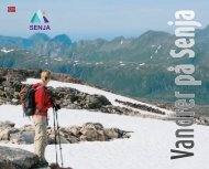
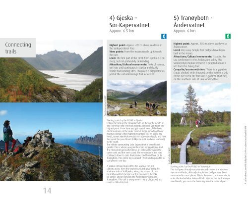
4) Gjeska –Sør-KapervatnetApprox. 6.5 km5) Tranøybotn -ÅndervatnetApprox. 6 kmConnect<strong>in</strong>gtrailsHighest po<strong>in</strong>t: Approx. 420 m above sea level <strong>in</strong>the Sørkaperskaret PassView po<strong>in</strong>ts: From the mounta<strong>in</strong>side up towardsthe passLevel: The first part of the climb from Gjeska is a bitsteep, but not particularly demand<strong>in</strong>gAttractions/Cultural monuments: Tofts of houses,turf huts and boathouses <strong>in</strong> Gjeska and clearlyvisible boat land<strong>in</strong>g sites. This place is signposted aspart of the cultural heritage trail <strong>in</strong> Torsken.Highest po<strong>in</strong>t: Approx. 105 m above sea level atÅndervatnet.Level: Very easy. Simple foot bridges have beenbuilt <strong>in</strong> the moors.Attractions/Cultural monuments: Skoglia, thelast settlement <strong>in</strong> the Ånderdalen valley. TheVardnesmyra Nature Reserve is situated about 1km from the hik<strong>in</strong>g trail.Campsite/accommodation: There is a gapahuk(rustic shelter) with firewood on the northern sideof the river near the ford and a gamme (turf hut)on the southern side of Lake Åndervatnet.F<strong>in</strong>nes©TRSør-Kapervatnet©HPP14The view towards Okshornan©RSStart<strong>in</strong>g po<strong>in</strong>t: by the FV243 <strong>in</strong> GjeskaFollow the trail up the mounta<strong>in</strong>side on the northern side ofthe Tverrelva River. The trail ascends a bit until you reach thehighest po<strong>in</strong>t. From here you get a great view of the fjordsand mounta<strong>in</strong>s on the outer coast of <strong>Senja</strong>, <strong>in</strong>clud<strong>in</strong>g MountKvænan (<strong>Senja</strong>’s third highest mounta<strong>in</strong>, 964 m above sealevel), Mount Henrikshovve (854 m above sea level), and fromthe top of the pass Mount Kollkjerka (653 m above sea level)to the south.The hillside surround<strong>in</strong>g Lake Kapervatnet is considerablygentler. This is where you jo<strong>in</strong> the ma<strong>in</strong> <strong>Senja</strong> på langs trail.The hik<strong>in</strong>g trail generally follows an old road between theouter coast and the <strong>in</strong>ner coast. The rema<strong>in</strong>der of the roadcont<strong>in</strong>ues down to Lake Åndervatnet and from there on toTranøybotn. This entire leg is around 19 km and is possible tocomplete <strong>in</strong> one day.A similar old road turns off to the south at the firstplateau across from the county road and goes along thesouthern side of Kollkjerka, along the shores of LakeHenrikhovvatnet (people used to row across the lakeby canoe) and on towards the Ånderdalen valley andTranøybotn. This trail is overgrown <strong>in</strong> many places and as aresult is difficult to f<strong>in</strong>d.Ånderdalen©HPPStart<strong>in</strong>g po<strong>in</strong>t: by the FV860 <strong>in</strong> TranøybotnThis trail goes through easy terra<strong>in</strong> and crosses the Vardnesmyramarshlands, although simple foot bridges have beenconstructed <strong>in</strong> most places. This is the most common route toenter the Ånderdalen National Park. West of the Vardnesmyramarshlands, you cross the boundary <strong>in</strong>to the national park.A coffee break on Mt Dalfjellet (644 m above sea level)©HPP