MCWP-3-11.3-Scouting-and-Patrolling
MCWP-3-11.3-Scouting-and-Patrolling
MCWP-3-11.3-Scouting-and-Patrolling

You also want an ePaper? Increase the reach of your titles
YUMPU automatically turns print PDFs into web optimized ePapers that Google loves.
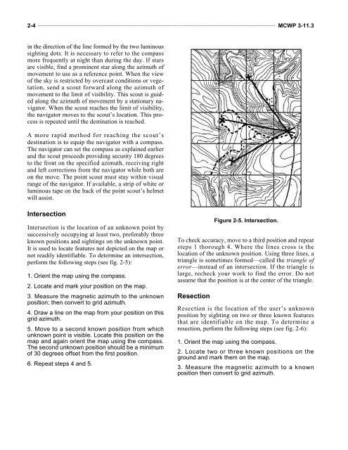
2-4 ______________________________________________________________________________________________ <strong>MCWP</strong> 3-<strong>11.3</strong>in the direction of the line formed by the two luminoussighting dots. It is necessary to refer to the compassmore frequently at night than during the day. If starsare visible, find a prominent star along the azimuth ofmovement to use as a reference point. When the viewof the sky is restricted by overcast conditions or vegetation,send a scout forward along the azimuth ofmovement to the limit of visibility. This scout is guidedalong the azimuth of movement by a stationary navigator.When the scout reaches the limit of visibility,the navigator moves to the scout’s location. This processis repeated until the destination is reached.A more rapid method for reaching the scout’sdestination is to equip the navigator with a compass.The navigator can set the compass as explained earlier<strong>and</strong> the scout proceeds providing security 180 degreesto the front on the specified azimuth, receiving right<strong>and</strong> left corrections from the navigator while both areon the move. The point scout must stay within visualrange of the navigator. If available, a strip of white orluminous tape on the back of the point scout’s helmetwill assist.IntersectionIntersection is the location of an unknown point bysuccessively occupying at least two, preferably threeknown positions <strong>and</strong> sightings on the unknown point.It is used to locate features not depicted on the map ornot readily identifiable. To determine an intersection,perform the following steps (see fig. 2-5):1. Orient the map using the compass.2. Locate <strong>and</strong> mark your position on the map.3. Measure the magnetic azimuth to the unknownposition; then convert to grid azimuth.4. Draw a line on the map from your position on thisgrid azimuth.5. Move to a second known position from whichunknown point is visible. Locate this position on themap <strong>and</strong> again orient the map using the compass.The second unknown position should be a minimumof 30 degrees offset from the first position.6. Repeat steps 4 <strong>and</strong> 5.To check accuracy, move to a third position <strong>and</strong> repeatsteps 1 thorough 4. Where the lines cross is thelocation of the unknown position. Using three lines, atriangle is sometimes formed—called the triangle oferror—instead of an intersection. If the triangle islarge, recheck your work to find the error. Do notassume that the position is at the center of the triangle.ResectionFigure 2-5. Intersection.Resection is the location of the user’s unknownposition by sighting on two or three known featuresthat are identifiable on the map. To determine aresection, perform the following steps (see fig. 2-6):1. Orient the map using the compass.2. Locate two or three known positions on theground <strong>and</strong> mark them on the map.3. Measure the magnetic azimuth to a knownposition then convert to grid azimuth.