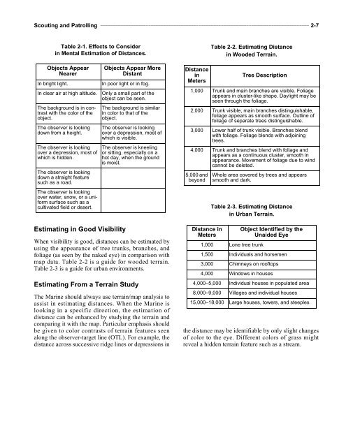
<strong>Scouting</strong> <strong>and</strong> <strong>Patrolling</strong> ___________________________________________________________________________________ 2-7Table 2-1. Effects to Considerin Mental Estimation of Distances.Table 2-2. Estimating Distancein Wooded Terrain.Objects AppearNearerIn bright light.In clear air at high altitude.The background is in contrastwith the color of theobject.The observer is lookingdown from a height.The observer is lookingover a depression, most ofwhich is hidden.The observer is lookingdown a straight featuresuch as a road.The observer is lookingover water, snow, or a uniformsurface such as acultivated field or desert.Objects Appear MoreDistantIn poor light or in fog.Only a small part of theobject can be seen.The background is similarin color to that of theobject.The observer is lookingover a depression, most ofwhich is visible.The observer is kneelingor sitting, especially on ahot day, when the groundis moist.DistanceinMetersTree Description1,000 Trunk <strong>and</strong> main branches are visible. Foliageappears in cluster-like shape. Daylight may beseen through the foliage.2,000 Trunk visible, main branches distinguishable,foliage appears as smooth surface. Outline offoliage of separate trees distinguishable.3,000 Lower half of trunk visible. Branches blendwith foliage. Foliage blends with adjoiningtrees.4,000 Trunk <strong>and</strong> branches blend with foliage <strong>and</strong>appears as a continuous cluster, smooth inappearance. Movement of foliage due to windcannot be deleted.5,000 <strong>and</strong>beyondWhole area covered by trees <strong>and</strong> appearssmooth <strong>and</strong> dark.Table 2-3. Estimating Distancein Urban Terrain.Estimating in Good VisibilityWhen visibility is good, distances can be estimated byusing the appearance of tree trunks, branches, <strong>and</strong>foliage (as seen by the naked eye) in comparison withmap data. Table 2-2 is a guide for wooded terrain.Table 2-3 is a guide for urban environments.Estimating From a Terrain StudyThe Marine should always use terrain/map analysis toassist in estimating distances. When the Marine islooking in a specific direction, the estimation ofdistance can be enhanced by studying the terrain <strong>and</strong>comparing it with the map. Particular emphasis shouldbe given to color contrasts of terrain features seenalong the observer-target line (OTL). For example, thedistance across successive ridge lines or depressions inDistance inMeters1,000 Lone tree trunkObject Identified by theUnaided Eye1,500 Individuals <strong>and</strong> horsemen3,000 Chimneys on rooftops4,000 Windows in houses4,000–5,000 Individual houses in populated area8,000–9,000 Villages <strong>and</strong> individual houses15,000–18,000 Large houses, towers, <strong>and</strong> steeplesthe distance may be identifiable by only slight changesof color to the eye. Different colors of grass mightreveal a hidden terrain feature such as a stream.
CHAPTER 3. ENEMY ACTIVITYA comm<strong>and</strong>er often acts on information furnished by scouts. Therefore, scoutsmust aim at absolute accuracy in reporting enemy activity. This chapter discussesestimating enemy strengths, interpreting signs <strong>and</strong> tracks, <strong>and</strong> knowing theenemy.3001. ESTIMATING ENEMY STRENGTHSIf troops cannot be counted, their strength may beestimated by: noting the length of time it takes varioustypes of moving columns to pass given point, the arearequired of a unit in camp or bivouac, or the front onwhich they are deployed. When the ground is dry,infantry on the march raise a low, thick cloud of dust,<strong>and</strong> motor vehicles or mechanized units raise athick, rapidly moving cloud. Additionally, throughpractice, a scout may gain information as to thestrength <strong>and</strong> composition of enemy forces by listeningto noises <strong>and</strong> observing lights, fires, <strong>and</strong> smoke. Ascout gains valuable experience in estimating enemystrengths by observing friendly forces in camp, on themarch, <strong>and</strong> deployed. The knowledge scouts gainduring field exercises of the appearance <strong>and</strong> tacticaldispositions of squads, platoons, companies, <strong>and</strong>larger units will be of great assistance in estimating thestrength <strong>and</strong> composition of enemy units observedunder various conditions.3002. INTERPRETING SIGNS ANDTRACKSIn addition to estimates made through direct observation,a scout may often be able to estimate size,composition, direction, rate of movement, condition,discipline, state of training, <strong>and</strong> morale of enemyforces through signs <strong>and</strong> tracks left behind.SignsThe examination of vacated enemy positions providesvaluable information. The size of a bivouac or defensearea ordinarily indicates the number of enemyoccupants. Clothing, ration containers, dumps, etc.,further indicate the quantity of the departed enemyforce. The condition of the bivouac area <strong>and</strong> amount ofmaterial ab<strong>and</strong>oned give an indication of the enemymorale, training, <strong>and</strong> discipline. A well-policed areaindicates good discipline. Rubbish, ration <strong>and</strong>smoking residue, <strong>and</strong> nonessential personal items ofequipment adrift indicate a lower state of morale,training, <strong>and</strong> discipline. Stores <strong>and</strong> material left behindin good condition may indicate a hasty movement orwithdrawal. Burned or destroyed materials indicate adeliberate, orderly withdrawal or movement. Letters,insignia, <strong>and</strong> other articles may reveal the identity ofthe enemy unit.In the case of a moving enemy, the distance betweenperiodic halts indicates the rate of march if enemyhabits relative to marches <strong>and</strong> halts are known. Conditionof the halt areas indicates the state of morale,training, <strong>and</strong> discipline.The physical condition of enemy dead <strong>and</strong> wounded<strong>and</strong> their personal equipment <strong>and</strong> weapons arereported. The general condition <strong>and</strong> state of maintenanceof destroyed or ab<strong>and</strong>oned vehicles shouldalso be reported.TracksA track is a mark left on the ground by the passage of aperson or object. Examination of tracks reveals informationabout the enemy.TroopsA few tracks overlapping each other on both sides of aroad or trail may indicate a patrol in staggeredformation. A large number of tracks indicates troops incolumn formation. A large column will wear a dryroad smooth <strong>and</strong> flat. In damp terrain, a freshly madetrack will have sharp edges; ordinarily, signs ofmoisture will disappear in about 15 minutes. A runner’stoes are dug into the ground; a walker’s footprintis fairly even.VehiclesThe type of track indicates whether the vehicle iswheeled or tracked. A scout acquires the necessaryexperience to make the proper determination byobserving vehicle tracks during training.