Consistent Zones - Calaveras County Government Services
Consistent Zones - Calaveras County Government Services
Consistent Zones - Calaveras County Government Services

You also want an ePaper? Increase the reach of your titles
YUMPU automatically turns print PDFs into web optimized ePapers that Google loves.
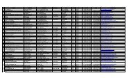
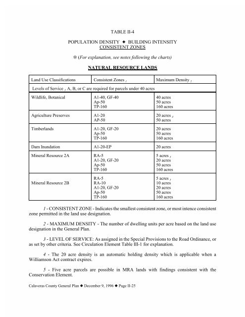
TABLE II-4POPULATION DENSITY J BUILDING INTENSITYCONSISTENT ZONES_ (For explanation, see notes following the charts)NATURAL RESOURCE LANDSLand Use Classifications <strong>Consistent</strong> <strong>Zones</strong> 1 Maximum Density 2Levels of Service 3 A, B, or C are required for parcels under 40 acresWildlife, BotanicalA1-40, GF-40Ap-50TP-16040 acres50 acres160 acresAgriculture Preserves A1-20AP-5020 acres 450 acresTimberlandsA1-20, GF-20Ap-50TP-16020 acres50 acres160 acresDam Inundation A1-20-EP 20 acresMineral Resource 2AMineral Resource 2BRA-5A1-20, GF-20Ap-50TP-160RA-5RA-10A1-20, GF-20Ap-50TP-1605 acres 520 acres50 acres160 acres5 acres 510 acres20 acres50 acres160 acres1 - CONSISTENT ZONE - Indicates the smallest consistent zone, or most intence consistentzone permitted in the land use designation.2 - MAXIMUM DENSITY - The number of dwelling units per acre based on the land usedesignation in the General Plan.3 - LEVEL OF SERVICE: As assigned in the Special Provisions to the Road Ordinance, oras set by other criteria. See Circulation Element Table III-1 for explanation.4 - The 20 acre density is an automatic holding density which is applicable when aWilliamson Act contract expires.5 - Five acre parcels are possible in MRA lands with findings consistent with theConservation Element.<strong>Calaveras</strong> <strong>County</strong> General Plan z December 9, 1996 z Page II-25
COMMUNITY DEVELOPMENT LANDSCommunity CentersA. Residential Areas1. Single-Family ResidentialLevel of Service Water, Sewer 6 <strong>Consistent</strong> <strong>Zones</strong> Maximum DensityA, B, or C Public, publicPublic, septicWell, septicD, E, or F Public, publicPublic, septicWell, septicR1R1-1, RR-1RR-5, RA-5RR-40, RA-40RR-40, RA-40RR-40, RA-407,000 sq. ft.1 acre5 acres40 acres40 acres40 acres2. Multi-Family ResidentialA, B, or C Public, publicPublic, publicPublic, septicPublic, septicWell, septicWell, septicR2-7000R3-3500R2-1R3-1R2-5R3-53,500 sq. ft.3,500 sq. ft.20,000 sq. ft.7,000 sq. ft.2.50 acres1.67 acresD, E, or F New multiple family residential not permittedB. Commercial, Industrial, Public Service Areas1. CommercialLevel of Service Water, Sewer <strong>Consistent</strong> <strong>Zones</strong> Maximum Density(Lot Coverage) 7A, B, or C Public, publicPublic, septicWell, septicRC, C1, C2, CPRC, C1, C2, CPRC, C1, C2, CP100 %, less setback &landscaping requirements100 %, less setback, septic &landscaping requirements100 %, less setback, septic &landscaping requirementsD, E, or F New Commercial or Industrial not permitted<strong>Calaveras</strong> <strong>County</strong> General Plan z December 9, 1996 z Page II-26
A, B, or C Public, publicPublic, septicWell, septic2. Light IndustrialM1, RM, M4M1, RM, M4M1, RM, M4100 %, less setback &landscaping requirements100 %, less setback, septic &landscaping requirements50 %, less setback, septic &landscaping requirementsD, E, or F New Industrial zones not permittedAny level ofServiceAny Service PS, ME No requirementsC. Resource <strong>Zones</strong>A, B, or C Any Service A1, GF 20 acresD, E, or F Any Service A1-40, GF-40 40 acresAny level ofServiceAny ServiceTP-160AP-50160 acres50 acres6 - WATER and SEWAGE: Public - provided by special district; Well - individual privatewell or small water system; Septic - individual private conventional septic system.7 - LOT COVERAGE - minimum parcel sizes are not established in commercial or industrialzones. Lot coverage is assigned based on the availability of water or method of sewage disposal,parcel sizes are preferred at no less than one acre with public water, and no less than five acres withwell and septic, unless smaller parcels are approved by the Department of Environmental Health.Residential CentersA. Residential Areas1. Single-Family ResidentialLevel of Service Water, Sewer <strong>Consistent</strong> <strong>Zones</strong> Maximum DensityA, B, C Public, publicPublic, septicWell, septicD, E, F Public, publicPublic, septicWell, septicR1-20000, RR-20000R1-1, RR-1RR-5, RA-5RR-40, RA-40RR-40, RA-40RR-40, RA-400.5 acres1 acre5 acres40 acres40 acres40 acres<strong>Calaveras</strong> <strong>County</strong> General Plan z December 9, 1996 z Page II-27
Future Single Family Residential1. Single-Family ResidentialLevel of Service Water, Sewer <strong>Consistent</strong> <strong>Zones</strong> Maximum DensityA, B, C Public, publicPublic, septicWell, septicD, E, F Public, publicPublic, septicWell, septicRR-5, RA-5RR-5, RA-5RR-5, RA-5RR-40, RA-40RR-40, RA-40RR-40, RA-405 acres5 acres5 acres40 acres40 acres40 acres2. Single-Family Residential with 50 % or greater slopesA, B, C Any Service RR-20, RA-20, A1 20 acresD, E, F Any Service RR-40, RA-40,A1-4040 acresIndustrial CorridorThe Industrial Corridor establishes a policy boundary within whichthe Industrial designation may be permitted. This section applies topotential industrial zones.Level of Service Water, Sewer <strong>Consistent</strong> <strong>Zones</strong> Maximum DensityA, B, C Public, publicPublic, septicWell, septicM1, M2, M4, RMM1, M2, M4, RMM1, M2, M4, RM100 %, less setback &landscaping requirements100 %, less setback, septic &landscaping requirements100%, less setback, septic &landscaping requirementsD, E, F Industrial uses not permittedRecreationally-oriented CommercialA. Direct recreationally-oriented commercial usesLevel of Service Water, Sewer <strong>Consistent</strong> <strong>Zones</strong> Maximum DensityAll levelsPublic, publicPublic, septicWell, septicRECRECREC35 %35 %35 %B. Indirect recreationally-oriented commercial uses shall be located where consistent withcommercial uses and zoning.<strong>Calaveras</strong> <strong>County</strong> General Plan z December 9, 1996 z Page II-28
City of Angels Sphere of InfluenceSee Table II-3, Page II-11In the event of amendments between the City's General Plan designations for its Sphere ofInfluence and the designations shown in the <strong>County</strong> General Plan, the City's designation shall takeprecedence until the <strong>County</strong>'s amendment process is complete. The intent is that the <strong>County</strong>'sdesignations within the Angels Sphere of Influence be consistent with the City's General Plan for thearea.Community, Special, & Specific PlansSee Tables in Land Use Element AppendixSee the applicable Community Plan for areas designated as Community Plan Areas on theFuture Land Use Map ( Arnold, Mokelumne Hill, Murphy-Douglas Flat, San Andreas, and ValleySprings). For Special Plans, see the Rancho <strong>Calaveras</strong> Ebbetts Pass Highway or the <strong>Calaveras</strong><strong>County</strong> Airport plans. For Specific Plans, see Saddle Creek (previously <strong>Calaveras</strong> <strong>County</strong> Club) orSpring Valley Estates._ IMPORTANT NOTES / EXPLANATIONSThe following items have a direct bearing on the determination of population density andbuilding intensity.&&&&&&&&&To determine population density, multiply the number of dwellings per acre by the persons perdwelling for the area.Minimum parcel size per dwelling or number of dwellings per maximum density mean the samenumber of dwelling units per acre.When multiple land use designations apply, the most restrictive land use takes precedence.Legally existing non conforming residential parcels may be zoned RR-X, if less than 5 acres, andRA-X if between 5 and 20 acres no matter which Natural Resource Lands classification thatproperty is located within.Lands in the Industrial Corridor which may have a base General Plan designation within NaturalResource Lands are still eligible to be considered for M1, M2, and M4 zoning if otherwiseconsistent with the policies of this element related to the Corridor.Resource zones (A1, AP, GF, TP, RA) are consistent in any land use designation.The PS (Public Service) zone is consistent in all designations.The REC (Recreation) zone may be consistent in any Natural Resource Lands classification,provided that the development proposed concurrently with the rezoning request isconsistent withthe policies of this element.The RM (Rural Home Industry) zone is consistent with the RR, RA, A1, AP, GF, and TP zones.<strong>Calaveras</strong> <strong>County</strong> General Plan z December 9, 1996 z Page II-29
REFERENCE TABLE OF ZONING DISTRICTSU UNCLASSIFIED InterimHS HIGHWAY SERVICE InterimA1 GENERAL AGRICULTURE ResourceAP AGRICULTURE PRESERVE ResourceGF GENERAL FOREST ResourceTP TIMBER PRODUCTION ResourceRA RESIDENTIAL AGRICULTURE ResourceRR RURAL RESIDENTIAL ResidentialR1 SINGLE FAMILY RESIDENTIAL ResidentialR2 TWO FAMILY RESIDENTIAL ResidentialR3 MULTIPLE FAMILY ResidentialRC RURAL COMMERCIAL CommercialRM RURAL HOME INDUSTRY Home BusinessC1 NEIGHBORHOOD COMMERCIAL CommercialC2 GENERAL COMMERCIAL CommercialCP PROFESSIONAL OFFICES CommercialM1 LIGHT INDUSTRY IndustrialM2 GENERAL INDUSTRY IndustrialM4 BUSINESS PARK IndustrialREC RECREATION RecreationPS PUBLIC SERVICE Miscellaneous<strong>Calaveras</strong> <strong>County</strong> General Plan z December 9, 1996 z Page II-30