Conservation Element - Calaveras County Government Services
Conservation Element - Calaveras County Government Services
Conservation Element - Calaveras County Government Services

Create successful ePaper yourself
Turn your PDF publications into a flip-book with our unique Google optimized e-Paper software.
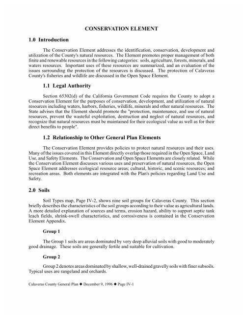
Soil Types map<strong>Calaveras</strong> <strong>County</strong> General Plan z December 9, 1996 z Page IV-2
Group 3Group 3 soils are moderately deep and moderately course textured materials oversandstones and volcanic ash. The soils have good natural drainage. Much of this land is used forcattle range. Where water is available, this land can be used for irrigated crops such as deciduousorchards and irrigated pastures. This land requires careful irrigation management because the soilsare strongly sloping to moderately steep, are only moderately deep, and have a slow surfacepermeability.Group 4The Group 4 soils are shallow and have a rocky texture. The base rock is slate andserpentine. Currently, these soils support annual grasses and some oaks and brush. The soils havegood natural drainage. This soil is used mostly as rangeland.Group 5The Group 5 soils support a cover of annual grasses and oaks, although scattered coniferscan sometimes be found on north-facing slopes. These soils are deep to shallow, well-drained,slightly acid, and rocky. The soils are, however, suitable for rangeland.Group 6The Group 6 soils are typified by acid, rocky, or stony soil over slate rock. Conifers growwell in this soil, although there will be occasional pockets of oaks, shrubs, and grasses. The soilscan be used for annual range and irrigated orchards (where water is available).Group 7Group 7 has course to moderately course, acid soils over weathered granite. The soilssupport a cover of conifers, oak, cedar, brush, and scattered perennial grasses. Natural drainageis good.Group 8The soils of this association are formed from volcanic rocks, cobbles, and ash that had beencemented together. They are moderately deep, well-drained, acid soils that contain cobbles. Thesoils are generally on moderately sloping to moderately steep lava caps. The soils support conifers,oaks, brush, and scattered perennial grasses and are best suited for timber production. Naturaldrainage is good.Group 9The final group of soils are actually rocky outcroppings, where the soil mantle is less than2 inches thick. There may be more than 50 percent exposed rock or partly weathered rock. Theseareas are suited to watershed and wildlife and recreation use.<strong>Calaveras</strong> <strong>County</strong> General Plan z December 9, 1996 z Page IV-3
TABLE IV-2LIVESTOCK PRODUCTION AND VALUE<strong>Calaveras</strong> <strong>County</strong> 1993Livestock and PoultryNumber ofHeadTotal LiveWeightValueCattle and Calves 12,700 72,200 $5,3683,600Sheep and Lambs 900 950 61,800Swine 1,500 1,950 94,800Poultry (includes game birds, squab, rabbits, etc.) — — 1,597,600Other Livestock (goats, emus, llamas, etc.) — — 160,000Livestock Products (milk, eggs, wool, mohair, etc. — — 2,008,000Bee Products — — 532,700TOTAL 14,050 66,840 $8,999,900Source:<strong>County</strong> of <strong>Calaveras</strong> Department of Agriculture and Weights and Measures, Report ofAgriculture, 1993.TABLE IV-3CROP ACREAGE, PRODUCTION, AND VALUE<strong>Calaveras</strong> <strong>County</strong>, 1993CropBearingAcres Production ValueFruit and Nut CropsAlmonds 31 18 tons $5,400Walnuts 731 290 tons 406,000Apples 140 250 tons 75,000Wine Grapes 260 625 tons 362,500Olives 250 500 tons 190,000Other Fruit Crops (cherries, berries,pears, peaches, etc.)— — 350,000Field CropsGrain Hay 300 450 tons 36,000Legume Hay 30 80 tons 7,200Native Hay 150 75 tons 3,400Irrigated Pasture 2,000 — 220,000Rangeland 412,000 — 4,120,000Other Field Crops (wheat, safflower,beans, etc.)— — 25,000<strong>Calaveras</strong> <strong>County</strong> General Plan z December 9, 1996 z Page IV-5
Vegetable CropsVegetable Crops (tomatoes, corn,peepers, melons, asparagus, etc.)— — 193,000Nursery CropsChristmas Trees — 18,000 trees 360,000Nursery Products — — 225,000TimberTimber Production — 82,429 mbf 1 35,110,600TOTAL 415,982 NA 41,689,101.00Notes: 1 mbf = million board feet.Source: <strong>County</strong> of <strong>Calaveras</strong> Department of Agriculture and Weights andMeasures, Report of Agriculture, 1993.3.2 Williamson Act LandsThe California Land <strong>Conservation</strong> Act, commonly known as the Williamson Act, wasenacted by the state legislature in 1965 to encourage the preservation of agricultural lands. Underthe Act, property owners may enter into contracts with the <strong>County</strong> to keep their lands inagricultural production for a minimum of 10 years, in exchange for property tax adjustments.Lands covered by Williamson Act contracts are assessed based on their agricultural value insteadof their potential market value under non-agricultural uses.There are over 125,000 acres of land in <strong>Calaveras</strong> <strong>County</strong> in agricultural preserves. Thelargest mass of these lands are in the southwestern portion of the county near the Stanislaus <strong>County</strong>border. The remaining sites tend to be scattered throughout the middle of the county. There areonly a few agricultural preserve areas in the northwest portion of the county, where the soil tendsto be very rocky. Nearly 90 parcels have applied for non-renewal, which will remove almost 7,000acres from the agricultural preserves by the year 2002.Important FarmlandsThe California Department of <strong>Conservation</strong> supplements the Soil <strong>Conservation</strong> Service soilsurvey with its Important Farmland Mapping and Monitoring Program. The program identifies fivecategories: Prime Farmlands, Farmlands of Statewide Importance, Unique Farmlands, Farmlandsof Local Importance, and Grazing Lands.Prime farmland has the best combination of physical and chemical characteristics for cropproduction. Farmland of statewide importance is not quite as good as prime soil, though still hassupported crop production for at least the three preceding years. Unique farmland ranks belowprime and statewide important farmlands, though is still capable of producing high economic valuecrops such as avocados and grapes. Finally, farmland of local importance ranks below the otherthree, yet may be important to the local economy due to its productivity (Department of<strong>Conservation</strong>, Important Farmland Categories).<strong>Calaveras</strong> <strong>County</strong> General Plan z December 9, 1996 z Page IV-6
High Capability Agriculture Lands map<strong>Calaveras</strong> <strong>County</strong> General Plan z December 9, 1996 z Page IV-7
Although there have been no prime agricultural lands identified in <strong>Calaveras</strong> <strong>County</strong>, manylands are capable of supporting agriculture. In general, lands with less than 30 percent slopes andsoil depths of two or more feet are suited for agricultural use.Potential Agricultural AreasAs shown on High Capability Agriculture Lands map, Page IV-7, there are some areas ofthe county that are currently not farmed, but that are arable and may be suitable for agriculturalproduction. The largest parcels are toward the center of the county, in fairly remote areas. Theexisting vegetation on this central portion is mostly conifers with some hardwoods and grass lands.Timber production and some rangeland may be suitable for this area. The arable areas nearer tothe San Joaquin <strong>County</strong> border are mostly grass lands and shrubs. Again, rangeland may besuitable in this area. If water is available, some fruit or field crops may also be possible.GENERAL PLAN RECOMMENDATIONSGoal IV-1: Preserve and encourage the use of land for agriculture purposes.Policy IV-1A: Allow resource production lands to remain available for agriculture andrural use.Policy IV-1B: Encourage Williamson Act contracts on lands outside of CommunityCenters, Residential Centers, Community, Special and Specific Plan Areas, and MixedUse/Master Project Areas.Implementation Measure IV-1B-1: Cooperate with the <strong>County</strong> AgricultureCommissioner when considering land use for lands within Williamson Actcontracts.Implementation Measure IV-1B-2: Require Community and Special Plans adoptedafter January 1, 1996, to address agriculture resources, and allow densities onresource lands within those Plan areas to reflect area preferences.Goal IV-2: Protect legally established agriculture from encroachment by incompatible land uses.Policy IV-2A: Review development proposals for possible encroachment upon legallyestablished agriculture.4.0 Forest ResourcesImplementation Measure IV-2A-1: Enforce "right to farm" provisions of the<strong>County</strong> Zoning Code.Forests are a significant natural and economic resource for <strong>Calaveras</strong> <strong>County</strong>. The forestlands provide for open space, recreation, and natural habitats, which is discussed in the Open Spaceelement. In addition, these lands are utilized for timber production.<strong>Calaveras</strong> <strong>County</strong> General Plan z December 9, 1996 z Page IV-8
4.1 Timber Production reversedTimber consists of trees of any species, whether planted or naturally occurring, which aremaintained for eventual harvest. Timber includes Christmas trees, but does not include nurserystock. Areas receiving the Timber Production Lands designation are identified as highly capableof supporting timber growth and harvesting. The soil information developed by the CaliforniaDepartment of Forestry (CDF) Cooperative Soil Vegetation Survey identifies soil classificationscapable of supporting timber. Lands containing soils in the Arvanitis and Palley Site classes 3through 7 (medium to very high) are most capable of timber production. These lands wereincluded as part of the lands shown on the High Capability Timberlands Map, Page IV-10.Most timber production occurs in the eastern section of the county on or near the StanislausNational Forest lands. Lands in <strong>Calaveras</strong> <strong>County</strong> are estimated as capable of producing about 60million board feet of lumber per year with some 20 million board feet coming from the StanislausNational Forest.The Stanislaus National Forest administers 75,072 acres within the county, which comprisesapproximately eleven percent of the county. As of 1986, American Forest Products Companycontrolled an estimated 67,000 acres in the eastern portion of the county. Fiberboard Corporation(a subsidiary of Louisiana Pacific), Snider Lumber Products Company, and Yuba River Lumber(a subsidiary of Bohemia Lumber Company) each controlled minor acreage (less than 1,000 acreseach) within the county's boundaries.1992 figures from the <strong>County</strong> Agriculture Commissioner indicate that 75,893 or 12 percentof the total land area is held in Timber Production Zone (TPZ) pursuant to the Forest TaxationReform Act of 1976. See High Capability Timberlands Map, Page IV-10.Timber production is allowed outside of those areas identified in the General Plan as TimberProduction Lands. It is not the intent of the Plan to restrict timber practices to lands receiving thetimber production designation.GENERAL PLAN RECOMMENDATIONSGoal IV-3: Preserve and encourage the expansion of high capability timber lands for timberprotection and harvest.Policy IV-3A: Allow lands located within high capability timberlands to remain availablefor timber production.Implementation Measure IV-3A-1: Allow a maximum density of one dwelling per20 acres on high capability timber lands outside of Community Centers, ResidentialCenters, Community, Special and Specific Plan areas, and the City of Angels sphereof influence.Implementation Measure IV-3A-2 : Utilize Timber Production Zones and contractswith private property owners under the California Timber Productivity Act of 1982,and the Forest Taxation Reform Act of 1976.<strong>Calaveras</strong> <strong>County</strong> General Plan z December 9, 1996 z Page IV-9
High Capability Timberlands Map<strong>Calaveras</strong> <strong>County</strong> General Plan z December 9, 1996 z Page IV-10
Goal IV-4:Maintain and increase timber land productivity.Policy IV-4A: Encourage sustained yield timber production and harvest.5.0 Mineral ResourcesImplementation Measure IV-4A-1: Utilize applicable provisions of the ForestImprovement Act of 1978 (Public Resources Code section 4790 et seq.).Areas receiving the Mineral Resource Lands designation have naturally occurring depositsof chemical elements or compounds formed from inorganic processes and organic substances.Mineral lands include both surface and subsurface deposits.5.1 Mining HistoryThe Gold Rush of the mid-1800's provided the major attraction to <strong>Calaveras</strong> <strong>County</strong> andthe rest of the Mother Lode. Since that time, mining has been a major component of the <strong>County</strong>'seconomy and livelihood. Between 1880 and 1962, the recorded value of minerals produced in<strong>Calaveras</strong> <strong>County</strong> amounted to over $200 million. Of that total, gold, limestone and copperaccounted for the greatest amount. Although production figures are not available for the largequantities of gold that were mined before 1880, it is documented that the largest single piece ofgold ever found in the Western Hemisphere -- weighing close to 150 pounds -- was unearthed atCarson Hill on November 22, 1854. Other minerals extracted in quantity in the past include quartzcrystal, copper, zinc, silver, lead, chromite, clay, sand, gravel and stone. At least 26 minerals havebeen produced commercially within the <strong>County</strong>. In more recent years, limestone, asbestos, sandand gravel, industrial minerals, and gold have accounted for most of the <strong>County</strong>'s mining industry.Even with increases in recycling of mineral products, a large demand remains for newlymined materials. New mineral discoveries are being made; however, development of new minesis a long process, often requiring several years and substantial investment before operation begins.5.2 Mining OperationsThe California Department of <strong>Conservation</strong> Division of Mines and Geology (DMG)maintains a database of mines and mining activity throughout the state. This source identifies 77mines in <strong>Calaveras</strong> <strong>County</strong>; however, more than half are presently classified as idle. The locationof these mines is shown in Mine Location map, Page IV-12. A detailed description of the productsand a list of the name, operating company, the main products and operational status of each mineis contained in the <strong>Conservation</strong> <strong>Element</strong> Appendix.5.3 Potential Mineral ResourcesThe history of mineral production and recent surveys suggest that much of <strong>Calaveras</strong><strong>County</strong> has the potential for further mineral resource development. As mining technology andprocesses improve over time, sites that were economically infeasible in the past may again becomelucrative. Mineral Resource map, Page IV-13 shows potential mineral resources areas in thecounty.<strong>Calaveras</strong> <strong>County</strong> General Plan z December 9, 1996 z Page IV-11
Mine Location map<strong>Calaveras</strong> <strong>County</strong> General Plan z December 9, 1996 z Page IV-12
Mineral Resource map<strong>Calaveras</strong> <strong>County</strong> General Plan z December 9, 1996 z Page IV-13
Asbestos and ChromiteAsbestos and chromite reserves are located in three general areas. As indicatedabove, the two existing, though abandoned, asbestos sites in the county are locatedsoutheast of Copperopolis just north of the Tuolumne <strong>County</strong> border. Small reserves ofasbestos and chromite are thought to exist north of Angels Camp, east of Highway 49.Additional small reserves are known northwest of San Andreas, near Valley Springs.GoldDeposits of gold-bearing rock are distributed over most of <strong>Calaveras</strong> <strong>County</strong>. Thehistory of gold in the region suggests that significant reserves may yet exist. DMGinformation suggests that reserves of lode gold exist in the Royal Mountain King Mine areajust north of Copperopolis and the Carson Hill mine located south-southeast of AngelsCamp.Potential placer gold deposits exist through out the county. Placer gold occursprimarily in river deposits; thus, most major drainages will have potential for such deposits.In particular, the Mokelumne River drainage in the northwestern part of the county and thedrainages east of Angels Camp are believed to contain placer gold deposits.Finally, several placer gold deposits are thought to exist in the eastern portion of thecounty; however, the significance of such deposits is not clear.DMG information points out that remnants of ancient river channels that have beencovered by volcanic or other geologic occurrences may yet contain significant placer golddeposits. Although many such areas have been prospected in the past, so-called "auriferousgravels" remain a potential source of economically viable placer gold.LimestoneSignificant reserves of limestone have been classified in the Kentucky House,Calaveritas, and Cave City deposits, located south of San Andreas. In addition, smalllimestone deposits have been identified generally east-southeast of San Andreas.Additional limestone deposits lie both west and south of Murphys, near the Tuolumne<strong>County</strong> border. Some of the potential limestone deposits also have the potential for talc andsilica deposits as well.Sand and GravelThe primary sand and gravel deposits lie in the northwestern portion of <strong>Calaveras</strong><strong>County</strong>, generally west of Valley Springs. See Mineral Resource map, Page IV-13.At a more detailed level, the State Department of Mines and Geology (DMG) conductssurveys of important mineral resource areas throughout the state. These surveys are based onUnited States Geologic Survey (USGS) 15 minute quadrangle maps. The most recent survey in<strong>Calaveras</strong> <strong>County</strong> was of the San Andreas Quadrangle, in the central-western portion of the county.A summary of this survey and classification system can be found in the <strong>Conservation</strong> <strong>Element</strong>Appendix.<strong>Calaveras</strong> <strong>County</strong> General Plan z December 9, 1996 z Page IV-14
The DMG survey notes five classes of minerals that are judged to be, or likely to be, presentin the San Andreas Quadrangle. These classes are:1. Base and precious metals (deposits formed by hydrothermal processes).2. Copper, zinc, gold, and associated metals (deposits formed by volcanogenicprocesses).3. Carbonate rock, asbestos, talc, and silica (industrial mineral deposits formed bydiverse processes).4. Chromite (deposits formed by magmatic concentration).5. Placer gold (deposits formed by residual and mechanical concentrations).5.4 Land Use Compatibility and ReclamationMineral deposits are rare occurrences, occupying a very small part of the earth's surface.<strong>Calaveras</strong> <strong>County</strong> is unique in that both metallic and nonmetallic deposits are widespreadthroughout the <strong>County</strong>. Unlike many other land uses, mineral extraction is limited to the physicalsite where the minerals occur. As a result, mineral resource lands do not coincide with theboundaries of Community Centers, Residential Centers, Community Plans, Special Plans, orSpecific Plans.In the last three decades, the <strong>County</strong> has experienced tremendous population growth. Manypeople, especially those moving into the <strong>County</strong> or buying recreation properties, have concernsabout the impacts of mining operations on neighboring property.In enacting the Surface Mining and Reclamation Act of 1975 (Public Resources Code§2710 et seq.), the State Legislature declared that mineral extraction is essential to the economicwell-being of the state and to the needs of society. The Legislature also recognized thatreclamation of mined lands is necessary to mitigate the environmental effects of mining and toprotect the public health and safety. Reclamation permits continued mining as well as protectionand future beneficial use of mineral lands after mining is completed.Reclamation plans specifically provide for control of erosion and flooding, waste disposal,and protection of water quality and watershed. The <strong>County</strong> Zoning Code requires a <strong>County</strong>approvedreclamation plan for all commercial mining operations. Because mining takes place indiverse ares in the <strong>County</strong>, reclamation operations may vary according to the geologic, topographic,climatic, biologic and social conditions present.5.5 Mineral Resource DesignationThe General Plan divides the <strong>County</strong>'s mineral resource areas into four categories, whichare depicted on the Potential Mineral Resource Area Map, Page IV-16, and explained in Table IV-4. Mineral extraction may occur in any of the four areas, but significant deposits are more likelyto occur in Areas 2A and 2B.<strong>Calaveras</strong> <strong>County</strong> General Plan z December 9, 1996 z Page IV-15
Potential Mineral Resource Areas map<strong>Calaveras</strong> <strong>County</strong> General Plan z December 9, 1996 z Page IV-16
Local study and evaluation of the <strong>County</strong>'s mineral resource lands considered lands ofpotential local significance as well as those of potential state and regional significance. Localevaluation is performed in addition to studies and designation made by the State Geologist.TABLE IV-4MINERAL RESOURCE AREASMRA1:Mineral Resource Area 1Lands not known to contain significant mineral deposits. Isolated mineraloccurrences may occur within this area.MRA2A:Mineral Resource Area 2AMRA2B:Mineral Resource Area 2BMRA3:Mineral Resource Area 3Lands that are being, or have been, intensively mined, and/or that havepromise of further mineral production.Lands that have had some mineral production in the past and/or that may beexpected to have some mining in the future.Lands that might contain minable deposits, but that up to now have not yetbeen sufficiently developed to demonstrate this.GENERAL PLAN RECOMMENDATIONSGoal IV-5: Preserve and manage the production of minerals to meet society's needs.Policy IV-5A: Encourage the development of mining uses on lands containing commerciallyvaluable mineral resources.Policy: IV-5B: Allow owners of land containing commercially valuable mineral resourcesoutside of Mineral Resource Areas 2A and 2B to apply for appropriate mineral extractionzoning.Implementation Measure IV-5B-1: Utilize the Mineral Extraction combining zoneto identify lands with commercial mineral potential.Implementation Measure IV-5B-2: Investigate the establishment of a MineralAdvisory Committee to make recommendations to the <strong>County</strong> regarding mineralresources potential.Goal IV-6: Protect mineral resources from encroachment by incompatible land uses.Policy IV-6A : Allow placement of the Mineral Extraction combining zone on landsidentified for residential, commercial or industrial uses.Implementation Measure IV-6A-1: Utilize the Mineral Extraction combining zoneto identify property on which future mining activities may be proposed.Policy:IV-6B: Allow alternative uses and reduced parcel sizes on lands in Mineral ResourceAreas 2A and 2B which do not contain commercially valuable mineral resources, ifconsistent with mining on nearby or adjacent properties.<strong>Calaveras</strong> <strong>County</strong> General Plan z December 9, 1996 z Page IV-17
Implementation Measure IV-6B-1: Consult the local mining association forrecommendations when considering less than one dwelling unit per 20 acres on landsin Mineral Resource Area 2A outside of Community Centers, Residential Centers,Community and Special Plan areas, and the City of Angels Sphere of Influence.Implementation Measure IV-6B-2: Consult the local mining association forrecommendations when considering less than one dwelling unit per 10 acres on landsin Mineral Resource Area 2B outside of Community Centers, Residential Centers,Community and Special Plan areas, and the City of Angels Sphere of Influence.Implementation Measure IV-6B-3: Develop regulations for permitting mining useswithin Community Centers, Residential Centers, Community, Special and SpecificPlan areas.Goal IV-7: Balance the interest of the <strong>County</strong>'s mining industry and residence.Policy IV-7A: Review proposed mining activities for potential negative impacts such asnoise, dust and traffic.Implementation Measure IV-7A-1: Require buffer areas or other mitigation measuresfor new mining activities locating near existing residential uses.Implementation Measure IV-7A-2: Require a use permit for all new miningoperations in the <strong>County</strong>, except for small mines less than or equal to 5 acres ormines located in the M2 zone.Goal IV-8: Protect public health and safety, and enable mined lands to be put to subsequentbeneficial use.Policy IV-8A: Review proposals for mineral extraction to assure minimal disturbance to theenvironment.6.0 Water ResourcesImplementation Measure IV-8A-1: Require that newly mined lands are reclaimed foropen space, conservation, agriculture, recreation or other beneficial uses.Implementation Measure IV-8A-2: Support and apply the Surface Mining andReclamation Act of 1975 (Public Resources Code section 2710 et seq.).The quantity, quality, and availability of water is vital to natural processes and humanactivity. Water is essential to develop housing, commerce, and industry; to maintain high qualityfish and wildlife habitats; and to provide recreational uses.Extending from the eastern part of California's Central Valley to the west slope of the SierraNevada Mountain Range, <strong>Calaveras</strong> <strong>County</strong> contains an abundance of water resources includingsurface water resources in the form of rivers, streams, and lakes, as well as reserves of groundwater.Significant hydrological features include three major rivers and numerous smaller streams, allflowing<strong>Calaveras</strong> <strong>County</strong> General Plan z December 9, 1996 z Page IV-18
in a generally southwestern direction. In addition to these natural channels, there are several mainwater supply ditches operated by water districts and public utilities. There are few flood plains, andthe only large lakes are reservoir impoundments.6.1 PrecipitationBecause of the great difference in elevation from west to east in the county, precipitationvaries. Average precipitation is 20 inches a year in the western region to 60 inches in the northeast.The rainy season is October 1 through May 1. Precipitation increases with altitude including bothsnow and rain in the higher elevations. Snow accounts for much of the precipitation in the higherelevations (up to 300 inches per year), while snowfall is rare in the foothills.6.2 Surface Water ResourcesThree significant rivers are the <strong>Calaveras</strong>, the Stanislaus, and the Mokelumne. These riverscarry the runoff of the west slope of the Sierra Nevada from east to west across <strong>Calaveras</strong> <strong>County</strong>,and into the Central Valley. These rivers provide significant habitat for wildlife. All three rivers aredammed in one or more places. The lower stretches of the rivers provide irrigation water for valleyagriculture and are used as municipal water supplies.<strong>Calaveras</strong> River originates in the Sierra Nevada mountains and extends west-southwestapproximately 60 miles toward and through the Stockton metropolitan area, terminating at the SanJoaquin River, outside of <strong>Calaveras</strong> <strong>County</strong>. The basin encompasses about 590 square miles, ofwhich 227 lie below New Hogan Dam.In the portion of the basin above New Hogan Dam and within the county, the primarytributaries are Esperanza, Jesus Maria, Calaveritas, San Antonio, and San Domingo Creeks. BelowNew Hogan Dam, the main tributaries in the county conveying runoff are the Cosgrove, Indian, andSouth Gulch.The Stanislaus River drains a narrow basin of about 980 square miles above the foothills onthe western slope of the San Joaquin River, forming the southern boundary of the county. Elevationsrange from 15 feet above sea level at the river mouth to 10,000 feet at the crest of the drainage area.There are three tributary forks (North, Middle and South) of the Stanislaus which join above NewMelones Lake, about 3 miles north of Parrots Ferry. North Fork is located within the county; Middleand South are in Tuolumne <strong>County</strong>.The Mokelumne River runs in three forks (North, Middle, and South) at the base of the SierraNevada in Alpine <strong>County</strong>. It flows southwest with the forks all joining near Lodi, then turnsnorthwest to end in the Sacramento River delta lands, emptying into the San Joaquin river about 20miles north of Stockton. The Mokelumne drains an area of about 661 square miles.The river forms the county's northern boundary with neighboring Amador <strong>County</strong>, and wasconsidered the division between the southern and northern mining districts during the Gold Rush.<strong>Calaveras</strong> <strong>County</strong> General Plan z December 9, 1996 z Page IV-19
Lakes and ReservoirsNo naturally-occurring lakes of notable size are located in the county, although somesmaller, mountain lakes are found in the Sierra Nevada. The six major reservoirs aredescribed below, and their features are summarized in Table IV-5. The locations of thereservoirs are shown on Water Resources map, Page IV-21.Camanche Reservoir. Owned by the East Bay Municipal Utility District, this reservoir onthe Mokelumne River was completed in 1963, with additional recreational and power usesadded in 1983. Capacity is 431,500 acre-feet. There are developed recreation areas at boththe north shore (located in Amador <strong>County</strong>) and the south shore (located in <strong>Calaveras</strong><strong>County</strong>). The lake can be used for swimming, fishing, boating, camping, and motelaccommodations; RV hook-ups are available. Undeveloped lands are used for grazing.Camanche Reservoir is a source of municipal and industrial water supplies, as well asproviding flood control.TABLE IV-5MAJOR RESERVOIRS<strong>Calaveras</strong> <strong>County</strong>, 1993Uses of ReservoirReservoir NameCapacity(acre-feet)MunicipalSupplyIrrigationFloodControl Power RecreationCamanche 431,500 2 2 2 2New Hogan 325,000 2 2 2New Melones 2,400,000 2 2 2 2Pardee 210,000 2 2 2 2Salt Springs 140,000 2 2Tulloch 50,000 2 2 2New Hogan Reservoir. New Hogan Reservoir was completed by the Army Corps ofEngineers in 1964 for purposes of flood control and water supply, and is located 28 milesnortheast of Stockton along the <strong>Calaveras</strong> River. Storage capacity is 325,000 acre-feet. Itis currently owned and managed by the Corps. The reservoir supplies irrigation water to theStockton East Water District and the <strong>Calaveras</strong> <strong>County</strong> Water District. The reservoirprovides multiple recreation uses, but is not as developed as Camanche. Substantialrecreational use includes fishing, boating, swimming, camping, and sightseeing.New Melones Reservoir. One of California's largest reservoirs, New Melones on theStanislaus River was completed in 1978 by the U.S. Bureau of Reclamation with a capacityfor 2,400,000 acre-feet. New Melones provides irrigation water, flood control, recreationalopportunities, and hydroelectric power.Water Resources map<strong>Calaveras</strong> <strong>County</strong> General Plan z December 9, 1996 z Page IV-20
Water Resources Map<strong>Calaveras</strong> <strong>County</strong> General Plan z December 9, 1996 z Page IV-21
Pardee Reservoir. Also owned by East Bay Municipal Utility District, Pardee straddles theMokelumne River above Camanche. Completed in 1929, its capacity is 210,000 acre-feet.Water in this reservoir is subject to strict water quality standards because it is a domesticdrinking water supply, so it is not used as intensively for recreational uses as othercountyreservoirs. Pardee Reservoir provides municipal and industrial water, flood control,recreation opportunities, and hydroelectric power.Salt Springs Reservoir. Located along the North Fork of the Mokelumne River on the<strong>Calaveras</strong>/Amador <strong>County</strong> border. Capacity is about 140,000 acre-feet. The reservoir wascompleted in 1931. Owned and operated by Pacific Gas and Electric (PG&E), its primarypurpose is to supply hydroelectric power, with fishing and recreation being secondary uses.Tulloch Reservoir. The Tulloch Reservoir was developed as part of the Tri-Dam Projectin the 1950s by the Oakdale and South San Joaquin Irrigation Districts, and is currentlymanaged by them. Tulloch Reservoir is located on the lower Stanislaus River below NewMelones Reservoir. Capacity is about 50,000 acre-feet. The water is used for irrigation anddomestic water purposes. Recreational opportunities include swimming and boating.In addition to the reservoirs described above, a number of smaller, older reservoirs built forirrigation and flood control purposes are found throughout the county. These include HunterReservoir (which provides drinking water to the City of Angels), Salt Springs Valley Reservoir(operated by the Rock Creek Irrigation District), Tiger Creek Reservoir, <strong>Calaveras</strong> Reservoir, EmeryReservoir, Schaads Reservoir, Old McCormick Reservoir, Copperopolis Reservoir, and the GoodwinDiversion Dam.Major Streams and Diversion CanalsThe following are the county's 22 major streams and diversion canals; lesser perennial andseasonal creeks are not listed.Angel's CreekBear CreekBig Meadow CreekBlue Creek<strong>Calaveras</strong> Public Utility DitchCalaveritas CreekCherokee CreekCosgrove CreekCoyote CreekEsperanza CreekForest CreekIndian CreekJesus Maria CreekLittlejohns CreekLove CreekMill CreekMoore CreekMurray CreekRock CreekSan Antonio CreekSan Domingo CreekSlate CreekUtica DitchYoungs CreekWetlandsSurface water resources located throughout <strong>Calaveras</strong> <strong>County</strong> include a variety ofwetlands. Typically they are found at the margins of ponds, lakes and streams, in low-lying areasthat collect precipitation, and in areas where groundwater intercepts the ground surface. Wetlandsmay be seasonal or perennial. There are many constructed ponds (stockponds, etc,) throughoutthe county.<strong>Calaveras</strong> <strong>County</strong> General Plan z December 9, 1996 z Page IV-22
Wetlands are highly productive natural habitats used for foraging and nesting by manytypes of wildlife. These areas are given a high priority for protection by the CaliforniaDepartment of Fish and Game and the U.S. Fish and Wildlife Service.Because of the widespread extent and the relatively small size of wetlands in <strong>Calaveras</strong><strong>County</strong>, they are not shown on Figure 1. The biological resource function types and the generallocation of wetlands are identified in more detail in the biological resources section.GroundwaterGroundwater resources in <strong>Calaveras</strong> <strong>County</strong> are highly variable with respect to quantity,dependability, depth, and quality. Groundwater Potential map, Page IV-24, shows groundwaterpotential areas as defined by the (earlier) <strong>County</strong> General Plan. These areas range from highpotential in the east-central portion of the county, to moderate potential east of Highway 49 andwest of Valley Springs. Low potential areas are found in the eastern uplands and the foothillvalleys west of Highway 49. Pockets of very low yield groundwater or mineralized groundwaterare found in roughly a north-south line extending from Pardee Reservoir to New MelonesReservoir.FloodingFlood plains in <strong>Calaveras</strong> <strong>County</strong> are very minor due to the deep ravines which have beencut by the rivers and the presence of flood control dams at the major reservoirs. Streamsideflooding, slow surface drainage areas, and dam inundation areas (from the potential failure ofexisting dams) are a concern.See the Safety <strong>Element</strong> for a more complete discussion of flooding concerns.Water QualityWater quality data sources for both surface and groundwater resources in <strong>Calaveras</strong><strong>County</strong> are scattered. Data is available for some reservoirs, and for rivers and streams nearproposed major county or commercial projects such as landfills and mines. Groundwater datafrom domestic or monitoring wells is also available mainly from these same areas. The U.S.Forest Service also has qualitative and some quantitative data on surface and groundwater qualityfor the 11 percent of the county that lies within the Stanislaus National Forest.Surface water quality is generally satisfactory to good, improving in quality (relative todrinking standards) at higher elevations. Available data indicate that the major rivers andreservoirs are significantly better in quality than the small streams. However, this may partiallybe the due to the fact that the available stream data is from the southwestern area of the countywhich contains soil and rock formations high in mineral content.Groundwater is generally within most drinking water standards, although some areas ofthe lower foothills appear to be very high in iron content as well as in certain other minerals inspecific locations. This is due to the slow movement of groundwater through mineralized rockformations and is to be unexpected in a mineral-rich region such as <strong>Calaveras</strong> <strong>County</strong>.<strong>Calaveras</strong> <strong>County</strong> General Plan z December 9, 1996 z Page IV-23
Groundwater Potential map<strong>Calaveras</strong> <strong>County</strong> General Plan z December 9, 1996 z Page IV-24
6.3 Public Water/UtilitiesSix different public utilities currently supply water to approximately two-thirds of the<strong>County</strong>'s population, as shown in Table IV-6.TABLE IV-6PUBLIC AGENCY WATER PURVEYORS<strong>Calaveras</strong> <strong>County</strong>, 1993Water AgencyArea ServedAngels Camp Utilities<strong>Calaveras</strong> <strong>County</strong> Water District (CCWD)<strong>Calaveras</strong> Public Utility District (CPUD)Murphys Union Public Utility DistrictPacific Gas and Electric (PG&E)Valley Springs Public Utility District (VSPUD)City of AngelsEbbetts Pass, Copperopolis, Copper Cove, West Point,Wilseyville, Sheep Ranch, LaContenta/ Rancho<strong>Calaveras</strong>San Andreas, Mokelumne Hill, Glencoe, Rail Road Flat,PalomaMurphys, Douglas Flat, VallecitoSells water wholesale to public utility districts from asystem of four reservoirs located outside the county.Valley SpringsThe <strong>Calaveras</strong> <strong>County</strong> Water District (CCWD) is the major supplier of water to largeareas of the county, while three public utility districts and the City of Angels supply theirrespective local areas.Mutual Water CompaniesIn addition to the public water purveyors listed above, there are a growing number ofmutual water companies. These are owned and operated by private property owner associationsand are listed in the following table.TABLE IV-7MUTUAL WATER COMPANIES<strong>Calaveras</strong> <strong>County</strong>, 1993Water CompanyBlue Lake Springs Mutual Water CompanyFly-In Acres Water CompanyLili Valley Water CompanyMineral Mountain EstatesSherman AcresShowshoe Springs Water CompanyArea ServedBlue Lake Springs Subdivision, ArnoldFly-In Acres Subdivision, Ebbetts PassWest Point areaAvery/Sheep Ranch RoadEbbetts Pass areaSnowshoe Springs Subdivision, Ebbetts Pass area<strong>Calaveras</strong> <strong>County</strong> General Plan z December 9, 1996 z Page IV-25
Water RightsIn most cases, the water suppliers in <strong>Calaveras</strong> <strong>County</strong> have sufficient water rights to meetexpected requirements in the <strong>County</strong>. The more immediate problem is the generation of capitalto develop the storage and distribution facilities needed to use the water.GENERAL PLAN RECOMMENDATIONSGoal IV-9: Preserve the <strong>County</strong>'s current water rights and additional water rights necessary tosupport the <strong>County</strong>'s full development potential.Policy IV-9A: Support the development of water projects in the <strong>County</strong> for domestic andirrigation purposes.Implementation measure IV-9A-1: Pursue available funding sources for thedevelopment of water projects in the <strong>County</strong>.Goal IV-10: Provide for adequate domestic water supplies.Policy IV-10A: Encourage continued cooperation among water suppliers in meeting thewater needs for the <strong>County</strong> as a whole.Implementation Measure IV-10A-1: Achieve orderly expansion of water districtsin the <strong>County</strong> through Local Agency Formation Commission (LAFCO) review.7.0 ENERGY SYSTEMThe energy system in <strong>Calaveras</strong> <strong>County</strong> is a complex system not only dependent on localresources but also upon state, national, and international resources.Fossil fuels (oil, natural gas, and coal), which supply most of the world's current energyuse, are now realized to be finite and virtually non-renewable.The <strong>County</strong>'s energy system operating today relies heavily upon imported fossil fuelswhich in time will become even more scarce and ever increasing in cost.One solution to energy supply problem rests in making a "transition" to a more efficientenergy system plus one that relies on alternative energy sources. Significant energy and dollarscan be saved through various conservation measures. Additionally, <strong>Calaveras</strong> <strong>County</strong> is fortunateto have an abundance of alternative energy sources. The combined potential of indigenous energysources such as hydro, solar, wind, and biomass exceeds current and projected energy needs forthe <strong>County</strong>'s future.Conversion FactorsEnergy is measured in British Thermal Units (BTU's). One BTU represents the quantityof heat required to raise the temperature of one pound of water one degree Farenheit. Forcomparison purposes, the following conversion factors are provided:<strong>Calaveras</strong> <strong>County</strong> General Plan z December 9, 1996 z Page IV-26
Cubic Foot of natural gasKilowatt Hour (KWH) of electricity(at the outlet)Kilowatt Hour of electricity(at the generating plant)Gallon of propaneTherm of natural gasGallon of regular gasolineGallon of diesel fuelBarrel of aviation fuelCord of Wood1,000 BTU3,423 BTU10,500 BTU91,500 BTU100,000 BTU119,000 BTU136,000 BTU5,048,000 BTU20,000,000 BTULeadership at the local level can assist a smooth transition to an efficient, renewableenergy-based economy. Realizing the energy opportunities available locally will requirecommitment and involvement from the entire community.GENERAL PLAN RECOMMENDATIONSGoal IV-11: Provide for a smooth transition for the use of renewable resources.Policy IV-11A: Encourage the reduced use of fossil fuels through conservation effortsand the use of alternative forms of energy.Implementation Measure IV-11A-1: Continue a program to provide energyconservation and development information for agencies, developers, and thegeneral public.Policy IV-11B: Promote the capability of solar energy use by future residentialsubdivisions.Implementation Measure IV-11B-1: Implement the State's Solar Rights Act andShade Control Act.Goal IV-12: Reduce the use of non-renewable energy in both the transportation and stationarysector.Policy IV-12A: Encourage energy savings in all buildings through modifications inbuilding and equipment operation and design.Implementation Measure IV-12A-1: Investigate the development of local energystandards for all new buildings in the <strong>County</strong> as a compliment to State standards.Policy IV-12B: Promote the use of carpooling, walking, and bicycling.Implementation Measure IV-12B-1: Investigate the establishment of a formalridesharing program in the <strong>County</strong>.Implementation Measure IV-12B-2: Strive to develop facilities to encouragebicycling and walking in the <strong>County</strong>.<strong>Calaveras</strong> <strong>County</strong> General Plan z December 9, 1996 z Page IV-27
Goal IV-13: Provide for development of hydro, solar, wind, and biomass resources to serve localresidents, businesses, and industry.Policy IV-13A: Promote the development of hydro-electric facilities in the <strong>County</strong>.Policy IV-13B: Encourage the use of solar energy especially in regard to spaceconditioning and domestic water heating in all new buildings.Policy IV-13C: Encourage the use of biomass energy in the forest products industry, andsolid and municipal waste management activities.Policy IV-13D: Encourage the use of wind for mechanical power and electrical power.Implementation Measure IV-13D-1: Solicit assistance in the development ofalternative energy resources from federal and State governments, utilities,municipalities, and the development community.<strong>Calaveras</strong> <strong>County</strong> General Plan z December 9, 1996 z Page IV-28